My Tracks  Picture of the Week

It’s the end of January already, and we have a final image from the Algodones Dune Field to talk about before moving on to a new project. I’m not sure that I’m ready. At the beginning of the month, when I started writing about the Algodones Dune Field, I wasn’t sure there was enough information for five articles. But, there was enough for that and more—like the relationship between the dune field, Lake Cahuilla, and the San Andreas Fault. If I aroused your curiosity, you’re going to have to hit the books yourself.

After working on this week’s picture, I realized that shifting sand was also a metaphor for time passing (Wasn’t there a daytime soap called, The Sands of Time? If not, there should have been.) As I examined my photos of endless piles of sand, I wondered why someone hadn’t come up with a way to put it to use. That was until my brain’s hammer came crashing down with an obvious answer. They have, or had—it’s already been done. You see the device every New Year with a picture of father time holding an hourglass about to run out of sand; of course, an hourglass. Why didn’t I think of that?

I even bought one a long time ago when I was wet behind the ears. I was still in the Army and stationed in Pasadena, California. My brandy new and very young bride—neither of us could legally drink in bars at the time—leased a furnished apartment three blocks north of Colorado Boulevard for a year. We didn’t need furniture as we set about nest building, so we bought shiny things from our local head-shop. There were posters taped to the wall (we couldn’t put nails in the drywall), kitchen trinkets, an alpaca throw rug, and a three-foot-high hourglass.

It was harvest gold that matched our appliances. It was big enough that we used it as a side table. We regularly turned it over when friends visited, but that soon got boring. I still don’t know how long it ran because I couldn’t afford a stopwatch, and when I tried timing it with the stove clock, my ADD kicked in, and I forgot what I was doing. I believe it was somewhere between 45 minutes to an hour.

After four years, the hourglass was one of the things I got from that divorce. I don’t know what happened to it, but I suspect that it turned bright flaming red in the eyes of one of my subsequent wives and wound up at Goodwill (assuming they were that kind to it). It wasn’t like I immediately noticed the day it was gone; I simply realized that the clock was no longer part of the decorations.

With how precise we can measure things these days, you’d think building an ultra-accurate hourglass would be possible. We could sift sand to within one micron, machine a precise orifice, and calculate the right weight to make the sand run out within a nanosecond. The results would make a super-accurate timepiece—once. It would quickly become out of tolerance because it grinds the hole imperceptibly larger while the sand flows. I guess I’ll just stick with my trusty ol’ Timex.

My Tracks - I photographed the set of tracks that I made on the Algodones Dunes to have a semi-permanent record that I was there.
My Tracks – I photographed the set of tracks that I made on the Algodones Dunes to have a semi-permanent record that I was there.

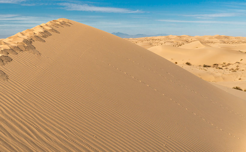
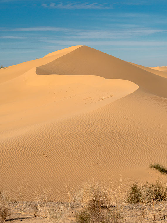
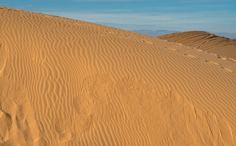
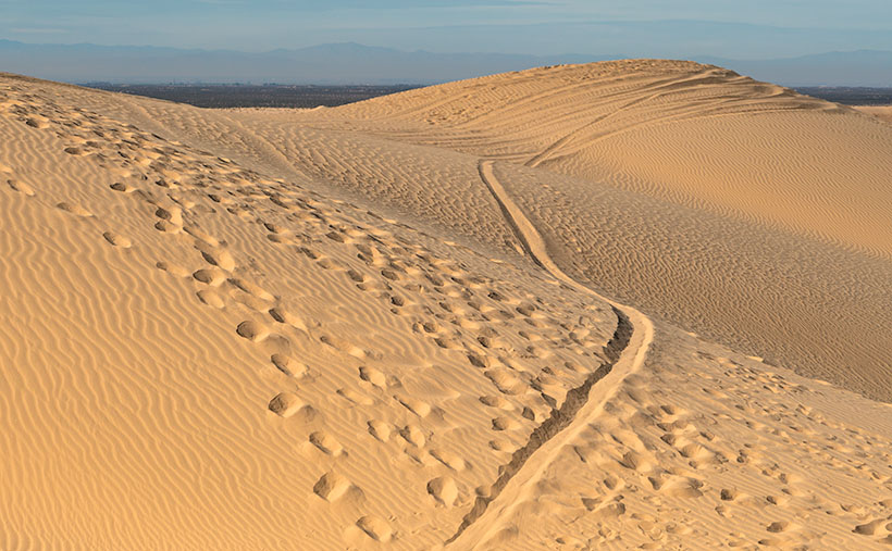
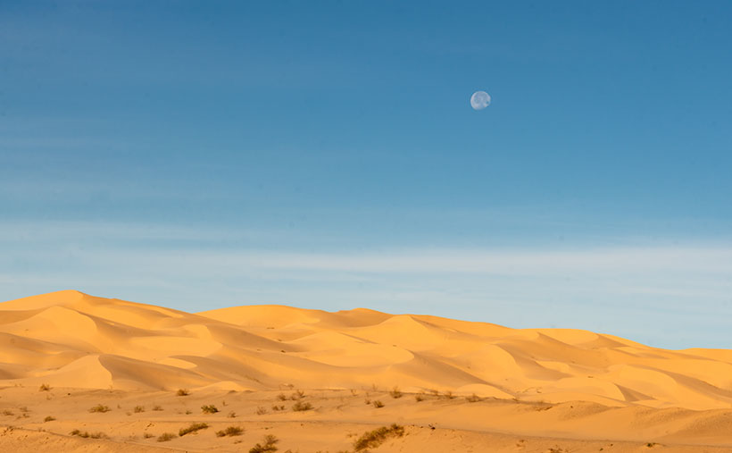
For this week’s picture, I wanted to show a semi-permanent record of my footprints in the sand. In real life, my tracks probably disappeared in hours—or days if the wind was calm. After taking last week’s photo, I headed back to the road. I turned before leaving the dune and shot this photo that I call My Tracks. The giant mess at the dune’s top is mine, and if you look closely, you’ll find other fainter tracks. Near the bottom are bug tracks, and there’s a set of coyote (or fox) tracks in the middle. There will always be some tracks in the dunes if you take time to look.

You can see a larger version of My Tracks on its Web Page by clicking here. Next week we move on to another location in search of natural beauty. Come back then and see where we landed.

Until next time — jw

Wilderness Dune  Picture of the Week

Although I’m sure that chasing each other around dunes in Mad Max-style is fantastic fun, being an artist and naturalist, I prefer my sand without tire tracks. If only there were an area of the Algodones Dunes like that. Fortunately for me—and you, if you feel the same—there is. It’s across the street in the North Algodones Dunes Wilderness Area. This set-aside area starts at the highway and continues north for another 15 miles to the Salton Sea. The only tracks you’ll find are those of the critters calling this home.

Wilderness Dune - You can explore dunes without tire tracks in the North Algodones Wilderness Area, which is across the street from the Imperial Dunes Recreation Area.
Wilderness Dune – You can explore dunes without tire tracks in the North Algodones Wilderness Area, across the street from the Imperial Dunes Recreation Area.

For four weeks, we’ve been walking with sand-filled shoes, and you’re asking, “Why is all of this here? Aren’t sandy beaches associated with large bodies of water?” Well, you’re right—here’s your gold star.

Here’s an interesting fact about Imperial Valley, much of Coachella Valley, and the Salton Sea—they’re below sea level. When you drive to San Diego on Interstate 8 and pass the Calexico exit—on the south side, there’s a large water tank rising from the lettuce fields with a painted mark indicating sea level. The grade runs downhill from there north to the Salton Sea. This entire basin was once underwater.

“So, was the Salton Sea much larger then?” No, grasshopper. California’s largest lake is not a ‘natural wonder.’ It’s an engineering blunder. The lake is the result of underestimating the Colorado River’s floods, which resulted in irrigation canals breaching their dykes, diverting the river for two years (1905-1907), and sinking the small community of Salton under 52 feet of water. The Sea suffers from decades of farm runoff laced with high fertilizer and salts that killed everything living in it. It’s now a toxic cesspool best viewed from miles away.

What actually happened was that the entire Salton Basin was part of the Sea of Cortez. Over time, the Colorado River Delta dumped enough sediment to bridge the gap between the mainland and a mountain chain off the western shore (today called Baja California). Like how the Mississippi formed Lake Pontchartrain in Louisiana. The historic landlocked body of water is named Lake Cahuilla (don’t confuse it with the Cholula hot sauce, as I did).

After the last Ice Age, Lake Cahuilla (ka-we-a) began to dry because there was not enough runoff to keep it filled. It finally went dry sometime after 1580. We know the lake existed then because the Spanish sailed ships past the delta into the lake. Today researchers have evidence of old shorelines and native archeological sites around them, providing evidence that people lived in the area for centuries. On the lake’s eastern shore was the Algodones Dunes. Geologists believe that the prevailing northeasterly winds carry Salton Basin sand aloft then dumps it at the foot of California’s Chocolate Mountain Range. Aw geez, now that Queen Anne has read this, she wants to go there because she thinks it’s where Willy Wonka lives.

This week’s photo shows a pristine dune I took from the roadside. The bad news is that you can’t stop here for at least two miles on either side of the fee area described in previous posts. So, to get this shot, I could’ve parked far away and hiked back (uphill in both directions) or paid the $35.00 fee. I’m lucky and glad that the Rangers took a day off.

You can see a larger version of Wilderness Dune on its Web Page by clicking here. Next week we’ll have the final Algodones Dunes story, so come back then.

Until next time — jw

Dune Avalanche Picture of the Week

Dune Avalanche - When the angle of wind-blown sand meets or exceeds 35 degrees, the sand collapses under its own weight and slides down the dune's leeward face.
Dune Avalanche – When the angle of wind-blown sand meets or exceeds 35 degrees, the sand collapses under its weight and slides down the dune’s leeward face.

My sisters and I never got to play in sandboxes when we were toddlers. My dad said it was because the cats kept covering us (cue drum). That joke was the extent of my dune knowledge until this month’s project. It turns out that they’re pretty complex.

For example, I thought they were a large pile of uniform sand grains. Not so. Only the grains on the surface layer are the same. Below—about a yard (or a meter, if you’re Canadian)—is another layer where the sand grains are large enough that wind can’t lift them. The surface has even more refined grains that get picked up and suspended in the air—like dust—and carried to faraway places. Recently, scientists found that dust from the Sahara Desert is held aloft high in the trade winds and falls back to earth in the Amazon Rain Forest. The settling dust is the source of nutrients supporting jungle plants. The soil in that area of Brazil is otherwise nutrient-poor because the river constantly flushes everything out to sea.

The weirdest fact that I learned was that dunes could sing—not like in tunes from Rocky Horror Picture Show—but a deep booming bass note (70-100 Hz). Conditions have to be perfect. The sand must be dried (in the hot summer), it must be windy, and the dunes must be tall—120 ft or more. The Algodones Dune field is not that high, but the Dumas Dunes between Barstow and Las Vegas are, so now I have to hear this for myself.

Here’s how it works. As wind moves over the field, the windward face of the dune forces air up and move faster—like an airplane wing. The fast-moving air picks up sand from the middle of the face and drops the sand at the top. When the angle of the top sand exceeds 35 to 38 degrees, it’s not able to support its weight, and it begins to slide down the dune’s leeward face—as we see in this week’s image called Dune Avalanche, but on a larger scale. As the sand slides, it creates vibrations reflected off the denser layer beneath—like the strings and body of a cello work together to make music. If you’d want a more thorough explanation from a more credible source, you can watch What Makes These Dunes Sing? (ft. @It’s Okay To Be Smart) on YouTube, but be warned, you need a good bass response from your speakers, or you won’t hear the song. And you thought last week’s story about the sandworms was fantastical.

I took this week’s picture at the Imperial Dunes Recreation Area, as you can guess by the tire tracks in the background. When I saw the sloughing sand, I knew that it was essential to the ecology of the dunes, but I didn’t appreciate why. After this week’s research, I’m glad that I snapped the photo, and—as I said above—I want to check out the Dumas Dunes and maybe go back to Death Valley. I want to hear their song—but do I want it bad enough to go when it’s 120 degrees?

You can see a larger version of Dune Avalanche on its Web Page by clicking here. Next week we’ll poke more into the beauty of the Algodones Dune Field, so come back then.

Until next time — jw

Predator Tracks Picture of the Week

We need to drive an hour to show you a different part of the Algodones Dunes. I hope you had breakfast because we’re not stopping. There are only two roads that cross the dunes, Interstate 8—east of Yuma and California State Highway 78. We’ll hop onto I-8 and head west to Holtville, then north to Brawley.

Most of this drive is flat and dull except for the towering green John Deere tractors that take up three lanes of the two-lane road. The farmers drive them on public roads to remind you that if you eat steak and salad in winter, this is where they were likely grown—either here in the Imperial Valley or Yuma.

Once we get to Brawley (there’s a bypass, so thankfully, we don’t have to go into town), we’ll turn west onto S.R. 78—the road to Blyth (boy, it keeps getting worse, doesn’t it). It isn’t far out of town that you see a cloud bank on the horizon—or at least that’s what it appears to be. The sand reflects light on a bright day, and the detail gets lost. The shapes and color begin to resolve in another mile, and the windshield fills with an overwhelming sea of golden sand.

We have arrived. This area of the dunes is the home base for So Cal dune-buggy enthusiasts. As soon as the highway starts up the sand, you’ll see Gecko Road on the right. It’s a paved street loaded with vendors, campers, and rangers. This road is a fee area, so we may have to buy a permit if the rangers come to work today. There are several designated camping areas along the road, and they’re full of R.V.s and trailers—even in the middle of the week. Judging from the size and luxury of these rigs, they’ve come from the L.A. Basin—and they’re richer than anyone from Arizona. There must be a thrill racing up and down dunes; otherwise, what’s the point? I wouldn’t try it in Archie, but with Bluto, I might. It could be fun.

Predator Tracks - An innocent victim was snatched from her friends by a giant sandworm California's Imperial Dunes .
Predator Tracks – An innocent victim was snatched from her friends by a giant sandworm in California’s Imperial Dunes.

It can also be dangerous. Some creatures live in the sand that nobody’s seen—their tracks are the only evidence that they’re real. They’re called sandworms, and they feed on unsuspecting victims as they try to cross. It’s true; they were in the ’90s movie Tremors, and you can see for yourself in this week’s picture called Predator Tracks. In it, you see footprints from a herd of bikini-clad tawny blond valley girls, moving north across the sand while staring at their phones. They were defenseless because they ignored their parent’s warning to take a chainsaw.

As they incessantly chattered about their Instagram likes, they overlooked the sandworm lurking behind a distant mound. Like dolphins feeding on a school of mackerel, the sandworm blindsided the girls. From their midst, it snatched Cassie in its massive jaws and drug her under as she complained about losing all her bars. None of the others noticed. They continued to the snack truck making snide remarks about how Cassie had just ghosted them. The only record of this tragedy is the tracks in the sand in my photo. Within a couple of days, even those will blow away.

You can see a larger version of Predator Tracks on its Web Page by clicking here. Next week we’ll hang around the Imperial Dunes and see what other sand tracks we can find.

Until next time — jw

Dune Moon Picture of the Week

When Queen Anne and I make our quarterly medical run-to-the-border, the drive is usually three-hours each way. Most of the time, we leave at dawn, see our dentist, buy prescriptions, and then come home. For me, those are long days behind the wheel; for Anne, not so much. She’s usually asleep in the passenger seat until her snoring wakes her up.

Occasionally when we have lab work done, or the customs line is three-hours long because the snow-birds have arrived, we’ll get a room in the elegant east-side Motel 6 and dine at the swanky four-star Denney’s. Our December visit was one of those occasions. Since I needed a topic for January’s posts anyway, we spent an extra night and took a circuitous route home—we’d go up to Blyth to work the Algodones Sand Dunes for this month’s project.

The great swath of sand starts about three miles south of the border outside of Los Algodones, Baja. It continues 45 miles northwest into the Coachella Valley (California’s Imperial Valley). They’re the most extensive contiguous dune system in the U.S. The dunes are also called the Imperial Dunes, Glamis Dunes, and Gordon’s Well. The name varies with location and the leisure activity you’re doing. Still, the entire system is officially named Algodones Dunes (in Spanish, it means cotton plant—the predominant crop grown on both sides of the border along the Colorado River). This week, we’ll start west of Yuma at the Mexican border—at Gordon’s Well.

Imagine it’s 1850, and you’ve traveled by wagon hundreds of miles across the scorching Sonoran Desert, forded a raging Colorado River, and finally crossed into California. You’d think your hardships are behind, but then, you’re greeted with 6 miles of Sahara-like sand to cross. With each step, you sink up to your knees. Even in 1926, when the nation’s first Ocean to Ocean highway was built (U.S. Route 80), the shifting sand was an engineering nightmare. They couldn’t simply scrape the sand away because the prevailing wind constantly covered it up again. Even today, if you’re caught in a windstorm along this section of road, you’ll risk a chance that the sand will blast the paint off your car.

Plank Road - You can see what's left of the old plank road on display at Gordon's Well.
Plank Road – You can see what’s left of the old plank road on display at Gordon’s Well.

The road builder’s solution for getting across was to build a plank road—movable wood sections on railroad-lie ties that floated on the sand’s top. It turned out to be challenging to maintain, but it drastically cut the crossing time when it was clear. Eventually, the planks were replaced with new and expensive asphalt, and eventually, it became Interstate 8. There is a section of the original plank road at Gordon’s Well on display. When you grow tired of looking at the old wood road, you can walk over to the border wall and lean on it.

Dune Moon - A waning gibbons moon setting over the Algodones Dunes west of Winterhaven, California.
Dune Moon – A waning gibbons moon sets over the Algodones Dunes west of Winterhaven, California.

As Anne and I drove west on the freeway, we spotted a waning moon setting on the dunes, so we looked for a place to stop. We’ve got stuck in these sands once before, so we were careful not to drive off the blacktop. I didn’t want to pay for another hook to come to yank us out. As you can see, we found a good spot and took this week’s picture called Dune Moon. The name could have been funnier if I had shot it during a particular summer month. Se la vie.

You can see a larger version of Dune Moon on its Web Page by clicking here. Next week we drive north up the Imperial Valley to visit the northern dune crossing. Be sure to come back and see what we found.

Until next time — jw

Snow Canyon—The Book      New book announcement

Do you remember from my first of this month’s post—Stacked Arches—where I said, “There’s enough to photograph within the park’s boundaries to fill a small picture book?” Well, there is—and I have—so I did. This short particular midweek post announces my latest book—Snow Canyon.

Snow Canyon - The Book - my latest book will be released next week, but you can get a sneak peak by clicking here.
Snow Canyon – The Book – my latest book will be released next week, but you can get a sneak peek by clicking here.

They haven’t released it yet; that will happen sometime next week on Amazon. It’s available in two versions. The first is a hardcover with a dust jacket. The paper I used was the best offered, so I expect the photos reproduction to be outstanding. The second variation has a soft cover and is printed on upgraded paper stock.

It’s a self-published book, like my others, so, unfortunately, its cost is prohibitive—unless you want to buy 100 copies or more. However, I wanted you—my subscribers—to enjoy it, so I’m providing a link to a free version in PDF format as a way of saying thanks for hanging out with me.

Once you download the PDF (2MB), you can read it, print it, tape it to your fridge, or line your parrot cage. It’s yours to do as you wish. Get your copy by clicking on the cover shot above or on this link: Snow Canyon—The Book.

I hope your New Years’ celebration is safe and sane. I’d like you to be around next year when we go to many exciting new places.

Now, we will return to our regularly scheduled programming.

Until next time — jw

Lava Grass  Picture of the Week

Christmas, along with the rest of the solstice holidays, is almost over. I hope that Santa brought you something better than the lump of coal I got. Queen Anne is on the couch in her bathrobe and tiara with a box of Kleenex. She’ll be useless until Amazon Prime stops showing Christmas movies. Since we won’t be back before then, we’d like to wish you the best New Year in 2022. Things have got to turn around eventually, so let’s give it a go one more time.

Today, I will finish up the year, and our visit to Snow Canyon State Park by talking about the other rock found there—basalt from recent lava flows. If wind, water, and ice sculpt sandstone, the cooled magma is geology’s Etch-a-Sketch reset button. The black rock covers the softer sandstone and forces water to change course. The runoff carves different canyons, like in the park.

As you explore the park’s north side, you’ll see basalt-covered cliffs. They used to be the canyon floor, but 27,000 years ago, the lava forced the drainage west and carved a new floor—now a couple of hundred feet lower. Snow Canyon has a couple of trails that wander through the jagged black rocks; the Lava Tube and the Cinder Cone trails. The latter is interesting because you can hike to the cone’s rim and look into the extinct caldera. However, the track is uphill, and on the east side of State Route 18, so we skipped it.

Lava Tube - When the magma skin cools and then ruptures, the flowing magma escapes leaving behind a cave.
Lava Tube – When the magma skin cools and then ruptures, the flowing magma escapes leaving behind a cave.

The Lava Tube Trail is shorter,  level, and leads to two lava tubes—which are places where the hardened surface fractures releasing the still molten magma inside to flow away. The remaining caves are sometimes big enough that you can crawl into and see where the bats and spiders live—I’ll pass. The above photo is the smaller tube, and visitors— braver than I—crawl into it.

Lava Grass - A small tuft of grass ekes out a living in barren basalt.
Lava Grass – A small tuft of grass ekes a living in barren basalt.

I find basalt a challenging subject to photograph. It’s like taking a picture of a black cat in a coal mine. To get any detail, you need to over-expose, which washes out the rich depth. Fortunately, and is the case with this week’s picture that I call Lava Grass, there’s enough green lichen growing on the rock to prevent the shadows from completely blocking up.

I feel lucky to have spotted the tuft of dried grass surviving in the barren rock. I concentrated hard on staying upright as I hiked the trail in the early morning. The jagged basalt is not skin-friendly and will likely draw blood if you fall on it. And—silly me—I left my bicycle helmet at home.

You can see a larger version of Lava Grass on its Web Page by clicking here. Next week we start a new year, with a new project in a new location. Be sure to come back and see where the road takes us.

Until next time — jw