Eagletail Peak  Picture of the Week

In last week’s article, I mentioned that the Eagletail Wilderness encompassed two desert mountain ranges and the Sonoran Desert basin that lies between them. The Eagletail Range was one, while the other is a chain known as Cemetery Ridge. After I gave you their name, I made an offhand remark about how they got that name. Well, I accepted that question as this week’s homework assignment, boys and girls. Here’s what I found—nothing.

Cemetery Ridge - A 16 mile-long chain of mountains that make up the southwest flank of the Eagletail Mountain Wilderness Area.
Cemetery Ridge – This is a 16 mile-long chain of mountains that make up the southwest flank of the Eagletail Mountain Wilderness Area.

Well, that’s not wholly true because, in my handy Arizona Place Names book, there is this entry:

“This sixteen-mile-long and two-mile-wide, low range was the scene of the killing of several prospectors in the 1870s, according to local stories. Their bodies are said to be buried on the ridge (sic), which is also known as Cemetery Hills.”

When I read that, I thought, “Alright, there’s an interesting historical story to tell my loyal readers.” So I, as the unofficial Marshall Trimble understudy, started a week of research that would have made Jimmy Olson proud. I wanted to find out what miners, who killed them, why, and where are they buried. I asked Alexa, Siri, Cortana, and Google’s unnamed assistant. None of them knew nothin’.

I did find out that I’m not the only person searching for those answers. Google referred me to the Desert Mountaineer blog. There I found the anonymous author had written a three-part journal covering Cemetery Ridge. The writer is a pretty good storyteller and photographer, but his passion is climbing mountains, and the photographs are incidental, kind of the opposite of what I do.

His three-part saga covers four days of driving the same roads I did, looking for graves. He travels with his dog, sleeps in his truck, and often stops to climb the mountains he passes—sometimes two or three in a day. I’m impressed! Anyway, after exploring the entire length of Cemetery Ridge, he didn’t find our legendary graves. He does mention the place where Deadman Wash crosses Cemetery Ridge on the west side. If ever there were a place to look, that would be where I’d start. It has all the intrigue of a pirate’s treasure map.

Framed between two of the Cemetery Ridge Mountains, Eagletail Peak's feathers lit by the sunrise.
Framed between two of the Cemetery Ridge Mountains, Eagletail Peak’s feathers lit by the sunrise.

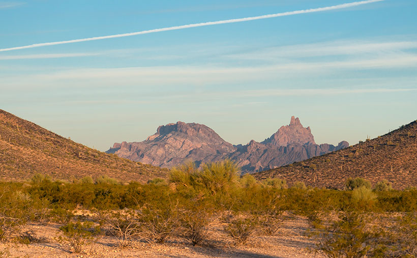
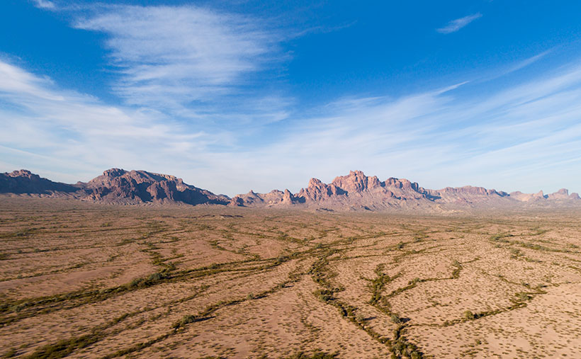
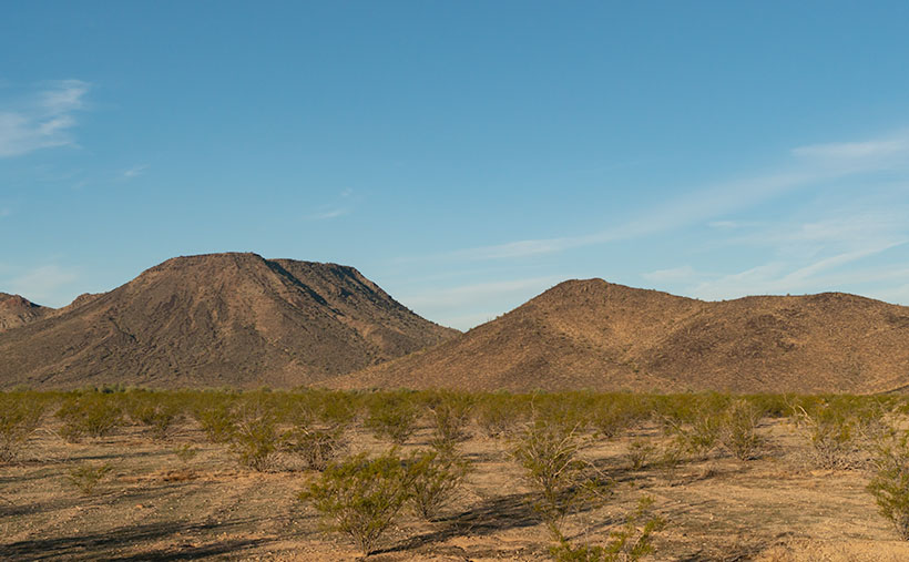
I shot this week’s image along the Arlington-Clanton Well Road on the south side of Cemetery Ridge. The Ridge’s mountains (like hills really) appear and disappear in a straight line for 16 miles. At one of those places where they slip below the surface like a giant sea-serpent, I saw Eagletail Peak framed and lit by the sunrise. You can make out the ‘tail feathers’ sticking up at the top in the picture. I want to explain that the Eagletail Wilderness is directly under the Los Angeles-Phoenix flyway, so contrails are part of the natural landscape, but they won’t let me fly my drone there.

You can see a larger version of Eagletail Peak on its Web Page by clicking here. Next week we go hunting for more treasure in the Eagletail Range. Come back then and see if we were successful.

Until next time — jw

Eagletail Mountains Picture of the Week


Eagletail Mountains - The Eagletail Mountain Wilderness Area is an hour west of Phoenix, and south of Interstate 10. Since you have to hike to see the good stuff, it's challenging for me to photograph properly.
Eagletail Mountains – The Eagletail Mountain Wilderness Area is west of Phoenix and south of Interstate 10. Since you have to hike to see the good stuff, it’s challenging to photograph correctly.

I find some places where it is difficult to photograph properly. Most of those are wilderness areas. Because they’re not accessible by road, you have to hike to get to the good stuff; that’s exciting visually. You know by now how I feel about hiking—I’m vehemently against it. However, sometimes you have to do things that make you uncomfortable.

The Eagletail Mountains are one of those places. Plenty of old jeep trails are running through the area, but since it was declared a wilderness and set aside in 1990, you can’t drive on them. Instead, you have to hike anywhere within its boundaries.

I last visited the Eagletails in 2003—when I first created my Website. Since I routinely update the site with newer and better photos, I discarded those shots long ago. I needed a new project, so I decided to revisit the Eagletail Wilderness and try my luck again.

There are two mountain ranges in the Eagletail Wilderness. Foremost is the Eagletail Range that runs north-south. If it were a hand on a clock, they would be in the 11:00 position. The other range is Cemetery Ridge (hmm, there’s got to be a story behind that name), a line of mountains that run northwest-southeast, or 9:30-10:00. Most of this wilderness fits within this triangle between the two ranges. That’s the justification that Congress used to preserve it. It is a complete example of two mountain ranges separated by a flat Sonoran Desert basin.

This week’s picture is of the western slope of the Eagletails. It’s an aerial shot taken with my drone. Since I can’t fly into a wilderness, it’s as close as I could get from the east side. It shows the jagged ridgeline with Eagletail Peak—the high point—at center-right. If you got closer, you’d see its top has several granite spires resembling feathers—so its name is descriptive.

The trouble is that the interesting geologic formations and petroglyphs are on the other side. For February, my challenge is to see how far I can walk in and show you what’s there. It’s been several years since I last twisted my ankle, so I’m about due.

You can see a larger version of Eagletail Mountains on its Web Page by clicking here. Next week, we move south and get a shot, including Cemetery Ridge. I promise to see how it got that name. Come back then and see what we found.

Until next time — jw

My Tracks  Picture of the Week

It’s the end of January already, and we have a final image from the Algodones Dune Field to talk about before moving on to a new project. I’m not sure that I’m ready. At the beginning of the month, when I started writing about the Algodones Dune Field, I wasn’t sure there was enough information for five articles. But, there was enough for that and more—like the relationship between the dune field, Lake Cahuilla, and the San Andreas Fault. If I aroused your curiosity, you’re going to have to hit the books yourself.

After working on this week’s picture, I realized that shifting sand was also a metaphor for time passing (Wasn’t there a daytime soap called, The Sands of Time? If not, there should have been.) As I examined my photos of endless piles of sand, I wondered why someone hadn’t come up with a way to put it to use. That was until my brain’s hammer came crashing down with an obvious answer. They have, or had—it’s already been done. You see the device every New Year with a picture of father time holding an hourglass about to run out of sand; of course, an hourglass. Why didn’t I think of that?

I even bought one a long time ago when I was wet behind the ears. I was still in the Army and stationed in Pasadena, California. My brandy new and very young bride—neither of us could legally drink in bars at the time—leased a furnished apartment three blocks north of Colorado Boulevard for a year. We didn’t need furniture as we set about nest building, so we bought shiny things from our local head-shop. There were posters taped to the wall (we couldn’t put nails in the drywall), kitchen trinkets, an alpaca throw rug, and a three-foot-high hourglass.

It was harvest gold that matched our appliances. It was big enough that we used it as a side table. We regularly turned it over when friends visited, but that soon got boring. I still don’t know how long it ran because I couldn’t afford a stopwatch, and when I tried timing it with the stove clock, my ADD kicked in, and I forgot what I was doing. I believe it was somewhere between 45 minutes to an hour.

After four years, the hourglass was one of the things I got from that divorce. I don’t know what happened to it, but I suspect that it turned bright flaming red in the eyes of one of my subsequent wives and wound up at Goodwill (assuming they were that kind to it). It wasn’t like I immediately noticed the day it was gone; I simply realized that the clock was no longer part of the decorations.

With how precise we can measure things these days, you’d think building an ultra-accurate hourglass would be possible. We could sift sand to within one micron, machine a precise orifice, and calculate the right weight to make the sand run out within a nanosecond. The results would make a super-accurate timepiece—once. It would quickly become out of tolerance because it grinds the hole imperceptibly larger while the sand flows. I guess I’ll just stick with my trusty ol’ Timex.

My Tracks - I photographed the set of tracks that I made on the Algodones Dunes to have a semi-permanent record that I was there.
My Tracks – I photographed the set of tracks that I made on the Algodones Dunes to have a semi-permanent record that I was there.

For this week’s picture, I wanted to show a semi-permanent record of my footprints in the sand. In real life, my tracks probably disappeared in hours—or days if the wind was calm. After taking last week’s photo, I headed back to the road. I turned before leaving the dune and shot this photo that I call My Tracks. The giant mess at the dune’s top is mine, and if you look closely, you’ll find other fainter tracks. Near the bottom are bug tracks, and there’s a set of coyote (or fox) tracks in the middle. There will always be some tracks in the dunes if you take time to look.

You can see a larger version of My Tracks on its Web Page by clicking here. Next week we move on to another location in search of natural beauty. Come back then and see where we landed.

Until next time — jw

Wilderness Dune  Picture of the Week

Although I’m sure that chasing each other around dunes in Mad Max-style is fantastic fun, being an artist and naturalist, I prefer my sand without tire tracks. If only there were an area of the Algodones Dunes like that. Fortunately for me—and you, if you feel the same—there is. It’s across the street in the North Algodones Dunes Wilderness Area. This set-aside area starts at the highway and continues north for another 15 miles to the Salton Sea. The only tracks you’ll find are those of the critters calling this home.

Wilderness Dune - You can explore dunes without tire tracks in the North Algodones Wilderness Area, which is across the street from the Imperial Dunes Recreation Area.
Wilderness Dune – You can explore dunes without tire tracks in the North Algodones Wilderness Area, across the street from the Imperial Dunes Recreation Area.

For four weeks, we’ve been walking with sand-filled shoes, and you’re asking, “Why is all of this here? Aren’t sandy beaches associated with large bodies of water?” Well, you’re right—here’s your gold star.

Here’s an interesting fact about Imperial Valley, much of Coachella Valley, and the Salton Sea—they’re below sea level. When you drive to San Diego on Interstate 8 and pass the Calexico exit—on the south side, there’s a large water tank rising from the lettuce fields with a painted mark indicating sea level. The grade runs downhill from there north to the Salton Sea. This entire basin was once underwater.

“So, was the Salton Sea much larger then?” No, grasshopper. California’s largest lake is not a ‘natural wonder.’ It’s an engineering blunder. The lake is the result of underestimating the Colorado River’s floods, which resulted in irrigation canals breaching their dykes, diverting the river for two years (1905-1907), and sinking the small community of Salton under 52 feet of water. The Sea suffers from decades of farm runoff laced with high fertilizer and salts that killed everything living in it. It’s now a toxic cesspool best viewed from miles away.

What actually happened was that the entire Salton Basin was part of the Sea of Cortez. Over time, the Colorado River Delta dumped enough sediment to bridge the gap between the mainland and a mountain chain off the western shore (today called Baja California). Like how the Mississippi formed Lake Pontchartrain in Louisiana. The historic landlocked body of water is named Lake Cahuilla (don’t confuse it with the Cholula hot sauce, as I did).

After the last Ice Age, Lake Cahuilla (ka-we-a) began to dry because there was not enough runoff to keep it filled. It finally went dry sometime after 1580. We know the lake existed then because the Spanish sailed ships past the delta into the lake. Today researchers have evidence of old shorelines and native archeological sites around them, providing evidence that people lived in the area for centuries. On the lake’s eastern shore was the Algodones Dunes. Geologists believe that the prevailing northeasterly winds carry Salton Basin sand aloft then dumps it at the foot of California’s Chocolate Mountain Range. Aw geez, now that Queen Anne has read this, she wants to go there because she thinks it’s where Willy Wonka lives.

This week’s photo shows a pristine dune I took from the roadside. The bad news is that you can’t stop here for at least two miles on either side of the fee area described in previous posts. So, to get this shot, I could’ve parked far away and hiked back (uphill in both directions) or paid the $35.00 fee. I’m lucky and glad that the Rangers took a day off.

You can see a larger version of Wilderness Dune on its Web Page by clicking here. Next week we’ll have the final Algodones Dunes story, so come back then.

Until next time — jw

Dune Avalanche Picture of the Week

Dune Avalanche - When the angle of wind-blown sand meets or exceeds 35 degrees, the sand collapses under its own weight and slides down the dune's leeward face.
Dune Avalanche – When the angle of wind-blown sand meets or exceeds 35 degrees, the sand collapses under its weight and slides down the dune’s leeward face.

My sisters and I never got to play in sandboxes when we were toddlers. My dad said it was because the cats kept covering us (cue drum). That joke was the extent of my dune knowledge until this month’s project. It turns out that they’re pretty complex.

For example, I thought they were a large pile of uniform sand grains. Not so. Only the grains on the surface layer are the same. Below—about a yard (or a meter, if you’re Canadian)—is another layer where the sand grains are large enough that wind can’t lift them. The surface has even more refined grains that get picked up and suspended in the air—like dust—and carried to faraway places. Recently, scientists found that dust from the Sahara Desert is held aloft high in the trade winds and falls back to earth in the Amazon Rain Forest. The settling dust is the source of nutrients supporting jungle plants. The soil in that area of Brazil is otherwise nutrient-poor because the river constantly flushes everything out to sea.

The weirdest fact that I learned was that dunes could sing—not like in tunes from Rocky Horror Picture Show—but a deep booming bass note (70-100 Hz). Conditions have to be perfect. The sand must be dried (in the hot summer), it must be windy, and the dunes must be tall—120 ft or more. The Algodones Dune field is not that high, but the Dumas Dunes between Barstow and Las Vegas are, so now I have to hear this for myself.

Here’s how it works. As wind moves over the field, the windward face of the dune forces air up and move faster—like an airplane wing. The fast-moving air picks up sand from the middle of the face and drops the sand at the top. When the angle of the top sand exceeds 35 to 38 degrees, it’s not able to support its weight, and it begins to slide down the dune’s leeward face—as we see in this week’s image called Dune Avalanche, but on a larger scale. As the sand slides, it creates vibrations reflected off the denser layer beneath—like the strings and body of a cello work together to make music. If you’d want a more thorough explanation from a more credible source, you can watch What Makes These Dunes Sing? (ft. @It’s Okay To Be Smart) on YouTube, but be warned, you need a good bass response from your speakers, or you won’t hear the song. And you thought last week’s story about the sandworms was fantastical.

I took this week’s picture at the Imperial Dunes Recreation Area, as you can guess by the tire tracks in the background. When I saw the sloughing sand, I knew that it was essential to the ecology of the dunes, but I didn’t appreciate why. After this week’s research, I’m glad that I snapped the photo, and—as I said above—I want to check out the Dumas Dunes and maybe go back to Death Valley. I want to hear their song—but do I want it bad enough to go when it’s 120 degrees?

You can see a larger version of Dune Avalanche on its Web Page by clicking here. Next week we’ll poke more into the beauty of the Algodones Dune Field, so come back then.

Until next time — jw

Predator Tracks Picture of the Week

We need to drive an hour to show you a different part of the Algodones Dunes. I hope you had breakfast because we’re not stopping. There are only two roads that cross the dunes, Interstate 8—east of Yuma and California State Highway 78. We’ll hop onto I-8 and head west to Holtville, then north to Brawley.

Most of this drive is flat and dull except for the towering green John Deere tractors that take up three lanes of the two-lane road. The farmers drive them on public roads to remind you that if you eat steak and salad in winter, this is where they were likely grown—either here in the Imperial Valley or Yuma.

Once we get to Brawley (there’s a bypass, so thankfully, we don’t have to go into town), we’ll turn west onto S.R. 78—the road to Blyth (boy, it keeps getting worse, doesn’t it). It isn’t far out of town that you see a cloud bank on the horizon—or at least that’s what it appears to be. The sand reflects light on a bright day, and the detail gets lost. The shapes and color begin to resolve in another mile, and the windshield fills with an overwhelming sea of golden sand.

We have arrived. This area of the dunes is the home base for So Cal dune-buggy enthusiasts. As soon as the highway starts up the sand, you’ll see Gecko Road on the right. It’s a paved street loaded with vendors, campers, and rangers. This road is a fee area, so we may have to buy a permit if the rangers come to work today. There are several designated camping areas along the road, and they’re full of R.V.s and trailers—even in the middle of the week. Judging from the size and luxury of these rigs, they’ve come from the L.A. Basin—and they’re richer than anyone from Arizona. There must be a thrill racing up and down dunes; otherwise, what’s the point? I wouldn’t try it in Archie, but with Bluto, I might. It could be fun.

Predator Tracks - An innocent victim was snatched from her friends by a giant sandworm California's Imperial Dunes .
Predator Tracks – An innocent victim was snatched from her friends by a giant sandworm in California’s Imperial Dunes.

It can also be dangerous. Some creatures live in the sand that nobody’s seen—their tracks are the only evidence that they’re real. They’re called sandworms, and they feed on unsuspecting victims as they try to cross. It’s true; they were in the ’90s movie Tremors, and you can see for yourself in this week’s picture called Predator Tracks. In it, you see footprints from a herd of bikini-clad tawny blond valley girls, moving north across the sand while staring at their phones. They were defenseless because they ignored their parent’s warning to take a chainsaw.

As they incessantly chattered about their Instagram likes, they overlooked the sandworm lurking behind a distant mound. Like dolphins feeding on a school of mackerel, the sandworm blindsided the girls. From their midst, it snatched Cassie in its massive jaws and drug her under as she complained about losing all her bars. None of the others noticed. They continued to the snack truck making snide remarks about how Cassie had just ghosted them. The only record of this tragedy is the tracks in the sand in my photo. Within a couple of days, even those will blow away.

You can see a larger version of Predator Tracks on its Web Page by clicking here. Next week we’ll hang around the Imperial Dunes and see what other sand tracks we can find.

Until next time — jw

Dune Moon Picture of the Week

When Queen Anne and I make our quarterly medical run-to-the-border, the drive is usually three-hours each way. Most of the time, we leave at dawn, see our dentist, buy prescriptions, and then come home. For me, those are long days behind the wheel; for Anne, not so much. She’s usually asleep in the passenger seat until her snoring wakes her up.

Occasionally when we have lab work done, or the customs line is three-hours long because the snow-birds have arrived, we’ll get a room in the elegant east-side Motel 6 and dine at the swanky four-star Denney’s. Our December visit was one of those occasions. Since I needed a topic for January’s posts anyway, we spent an extra night and took a circuitous route home—we’d go up to Blyth to work the Algodones Sand Dunes for this month’s project.

The great swath of sand starts about three miles south of the border outside of Los Algodones, Baja. It continues 45 miles northwest into the Coachella Valley (California’s Imperial Valley). They’re the most extensive contiguous dune system in the U.S. The dunes are also called the Imperial Dunes, Glamis Dunes, and Gordon’s Well. The name varies with location and the leisure activity you’re doing. Still, the entire system is officially named Algodones Dunes (in Spanish, it means cotton plant—the predominant crop grown on both sides of the border along the Colorado River). This week, we’ll start west of Yuma at the Mexican border—at Gordon’s Well.

Imagine it’s 1850, and you’ve traveled by wagon hundreds of miles across the scorching Sonoran Desert, forded a raging Colorado River, and finally crossed into California. You’d think your hardships are behind, but then, you’re greeted with 6 miles of Sahara-like sand to cross. With each step, you sink up to your knees. Even in 1926, when the nation’s first Ocean to Ocean highway was built (U.S. Route 80), the shifting sand was an engineering nightmare. They couldn’t simply scrape the sand away because the prevailing wind constantly covered it up again. Even today, if you’re caught in a windstorm along this section of road, you’ll risk a chance that the sand will blast the paint off your car.

Plank Road - You can see what's left of the old plank road on display at Gordon's Well.
Plank Road – You can see what’s left of the old plank road on display at Gordon’s Well.

The road builder’s solution for getting across was to build a plank road—movable wood sections on railroad-lie ties that floated on the sand’s top. It turned out to be challenging to maintain, but it drastically cut the crossing time when it was clear. Eventually, the planks were replaced with new and expensive asphalt, and eventually, it became Interstate 8. There is a section of the original plank road at Gordon’s Well on display. When you grow tired of looking at the old wood road, you can walk over to the border wall and lean on it.

Dune Moon - A waning gibbons moon setting over the Algodones Dunes west of Winterhaven, California.
Dune Moon – A waning gibbons moon sets over the Algodones Dunes west of Winterhaven, California.

As Anne and I drove west on the freeway, we spotted a waning moon setting on the dunes, so we looked for a place to stop. We’ve got stuck in these sands once before, so we were careful not to drive off the blacktop. I didn’t want to pay for another hook to come to yank us out. As you can see, we found a good spot and took this week’s picture called Dune Moon. The name could have been funnier if I had shot it during a particular summer month. Se la vie.

You can see a larger version of Dune Moon on its Web Page by clicking here. Next week we drive north up the Imperial Valley to visit the northern dune crossing. Be sure to come back and see what we found.

Until next time — jw