A New Day’s Glow at the Granite Dells Picture of the Week - Prescott, Arizona

A subtle sunrise over the Granite Dells in Prescott, Arizona, highlighting lichen-covered rocks resembling toes and victory signs.
A New Day’s Glow at the Granite Dells – A playful sunrise at the Granite Dells, where imagination meets nature. The subtle glow highlights formations that evoke toes and victory signs, making for a captivating morning scene.

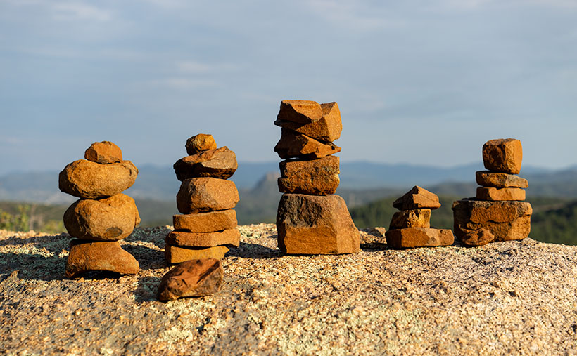
As an undergraduate in college, I signed up for a class in art history for three automatic credits. Many students complain that this required course is lame. Still, I must have accidentally learned something when I thought I was napping in the classroom because now and then, I’ll spot something on TV, and I get to turn to Queen Anne and spout some useless trivia to impress her—it doesn’t work, and I get the usual eye-roll. One of the things I wondered about in that class was why were so many of the Greek and Roman era statues damaged. Later, I found out that looters damaged them when they ripped the artwork from their pedestals. But I still wonder, “What happened to Venus de Milo’s arms, and where are those missing hands and feet?”

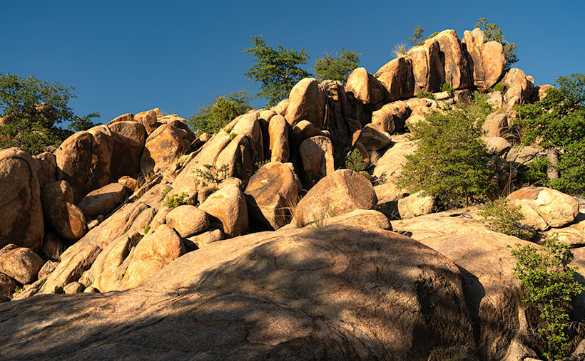
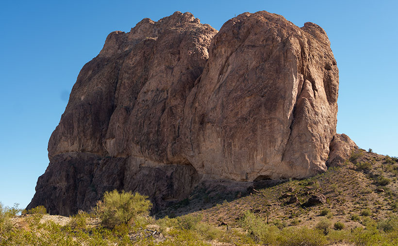
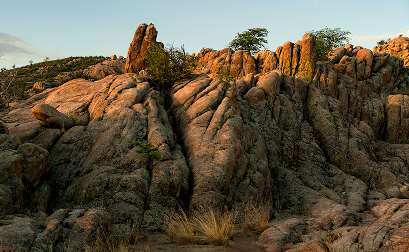
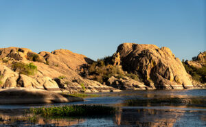
I may have found a partial answer, and it’s in the final image from our Granite Dells project. On my morning outing, when it wasn’t hot, and I had plenty of water, my brain was operating at its peak as I followed the well-worn trail before dawn. My primary focus was not falling, but that still left time for me to snap photos when I wasn’t moving. One of those shots is A New Day’s Glow at the Granite Dells—this week’s featured image. Like last week’s picture, I later saw things in this image that weren’t there when I was on the trail.

At first glance, the image may look like just another example of weathered granite in the Dells. But on closer inspection, it’s as if the place is a secret stash for all those missing statue appendages I wondered about in college. Along the ridge left of the center, there’s a right foot with two toes jutting into the air, obscured partially by the bush. To the right of the center, there’s a left foot, complete with a visible toenail on the big toe. The more you look, the more toes start appearing throughout the photo. Eureka! It’s like I’ve stumbled upon the lost’ foot locker’ of ancient art—a clandestine graveyard of dismembered statue feet! Perhaps they hide it under a blue tarp during the day; otherwise, it would have been discovered by now.

I’m not alone when I look at the Dells and see things that aren’t there. Another group of visionary men did the same thing over a century ago. They were farmers from Chino Valley and Prescott, looking for reliable water sources to irrigate their expanding agricultural lands. Ignoring the rugged beauty of the Granite Dells, they recognized an opportunity in the flow of Willow Creek and Granite Creek. In 1900, they constructed the first dam, damming Willow Creek and forming what is now known as Willow Lake. A few years later, in 1908, they dammed Granite Creek, creating Watson Lake. These manufactured reservoirs transformed the wasteland into valuable water storage and provided the area with dependable year-round water, fueling growth and prosperity. Today, the lakes and the surrounding Granite Dells continue to be a vital resource, offering a balance between human needs and natural beauty.

Evening sun illuminating the granite domes over Lake Wilson, contrasting the rugged rocks with the serene ripples of water.
Water and Rock: Evening at the Dells – A tranquil evening view of the Granite Dells, where the golden light dances on the domes and the calm waters of Lake Wilson whisper reflections. The balance of serenity and strength is captured in a moment.

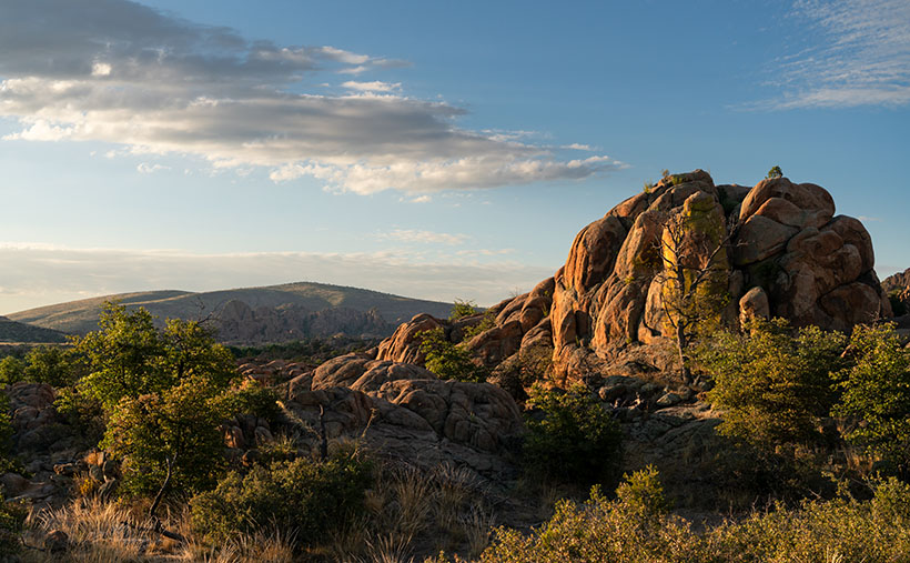
This week’s second photo shows Willow Lake waters lapping the Dells’s eastern shore. When the City of Prescott bought the lakes and surrounding land in 1997, they intended to preserve the area as a recreational preserve. And that’s how it worked out. Hikers, rock climbers, and old photographers use the dry sites, while other outdoor types like to get out on the water.

Granite Dells are more than just a collection of impressive rocks. Their charm lies in the subtle details and the stories they seem to tell. From imaginary toes to victory signs, from the gentle embrace of lichen to the lively dance of water plants, every visit unveils a new layer of beauty. We’re glad you joined us on the trails of Granite Dells, and we hope that you didn’t get frightened by the shape-shifting rocks. I have published two larger versions of this week’s image online, should you want to count the little piggies with roast beef. The first is on my Website (Jim’s web page), and the second is on my Fine Art America Page (FAA web page). I think it would be great to hear how many toes you found by leaving your count in the comments section below—of course, any snide remarks are welcome, too. We hope to see you back here next week when we begin a new project to get us through September—usually the last of our hot summer months.

Until next time
jw

Techniques: Playing with Reflections in Water

Capturing reflections in water can transform an ordinary photograph into a visually captivating image, providing a unique perspective and adding a sense of symmetry and depth. Whether it’s the clear reflection of a mountain in a calm lake or the distorted ripples of buildings in a bustling city canal, water reflections can be a photographer’s tool to create a sense of harmony and intrigue.

In this week’s second photo—Water and Rock: Evening at the Dells—the reflections in Willow Lake offer a mirror-like portrayal of the rock formations, doubling the visual impact and delivering a parallel world beneath the surface. These reflections emphasize the rock’s unique shapes and capture the colors and textures of the sky and landscape, enhancing the overall composition. Utilizing reflections requires keen observation and sometimes even waiting for the right moment when the wind calms and the water surface becomes still. Consider the angle of the light, the state of the water, and the composition to maximize the reflective effect. By experimenting with different perspectives and settings, reflections in water can become a decisive element in your photographic storytelling, elevating a simple scene into something extraordinary. Despite all that planning, sometimes you have to have dumb luck, as I did with this photo of the Ruby Range and Kluane Lake while on our 2016 Alaska adventure (see it here).

The Escalator Effect: Rock Formations in the Granite Dells Picture of the Week - Prescott, Ariozna

A golden stairway of rock formations ascending to a blue sky in the Granite Dells during sunset.
The Escalator Effect: Rock Formations in the Granite Dells – A natural escalator of golden rock formations, leading the eye toward the serene blue sky. A captivating example of the Dells’ rugged beauty captured at day’s end.

Thanks for tuning in to the third installment of my tromp through Prescott’s Granite Dells. We’ve moved to the park’s west side this week, north of Wilson Lake, where the trails are more challenging (physically and mentally) for an old coot like me. Despite the park departments placing white dots along the route as breadcrumbs, this Hansel managed to get lost three times. When I wasn’t lost, I scrambled over rocks and through thickets. To add to my misery, I started my hike in the afternoon, when the temperature was hot—even for Prescott.

Ah, the granite of Arizona, often found lounging in the sun, unbothered and with a certain rough charm. Unlike its posh cousin in Yosemite, it’s not entirely dressed to impress. While the Yosemite granite is a refined mix of quartz, feldspar, and biotite, giving it a smooth, elite look, Arizona’s granite is laid-back.

Arizona’s granite likes to hang out with some low-life friends, like mica and other composite minerals. It’s a mixed bag of characters not found in the high-end stuff. It’s a bit like the rebellious teenager of the geological world, not entirely fitting into the pristine and orderly world of Yosemite’s elite granite or New Hampshire’s distinguished, old-world charm.

Where other granites may be used for grand monuments or chic interior design, Arizona’s granite prefers the simpler life—gracing landscapes, lounging in gardens, or even being crushed into gravel for driveways. The added presence of mica gives it a bit of sparkle, but it’s more of a casual glint rather than a dazzling shimmer. It may not have the star power of its Yosemite counterpart, but it’s got character, grit, and a unique Southwestern flair that makes it stand out in its own right. And who doesn’t love a good underdog story? Especially one with a bit of sparkle!

When hunting down picture subjects, I look for unusual things that interest me. It may be a pattern, shape, texture, or something ordinary, but with exceptional lighting, photography loosely translates to ‘painting with light.’ But when I try to explain to others what I see in an image, my audience frequently gives strange looks, and they often raise their hands in defense before taking a step back for safety. For example, I was drawn to the inclining row of vertical rocks behind some horizontal slabs in this week’s image, titled The Escalator Effect: Rock Formations in the Granite Dells. My brain shouted, “Oooh! Oooh! Rock go up and down—rock go side to side.” That was enough encouragement for me to snap the shutter.

The composition still pleased me enough to process it this week, but as I worked on it, I began seeing things that could get me locked up. As I looked at the incline of vertical rocks, I wanted to push the right one over and watch the pile topple in a chain reaction—like a row of dominoes in a time-wasting but addictive video. Then, the rocks morphed into a flight of stairs or an escalator I wanted to climb. Then, to my horror, I saw the shape of a man covered in a leafy shadow blanket lying face-down at the foot of the stairs. Has he fallen? Is he injured? The city should put up handrails for us to hold onto. It’s a lawsuit waiting to happen.

A singular rock, bathed in golden light, resembling a deflated beach ball or Yosemite's Half Dome, in the Granite Dells.
One Among Many: A Golden Hour in the Granite Dells – A unique rock formation stands out against a backdrop of green pines and blue sky, its golden hues reminiscent of a beach ball or Yosemite’s Half Dome, frozen in time.

This week’s second image—One Among Many: A Golden Hour in the Granite Dells—isn’t nearly as complex. It’s only a round rock that climbed on top of a larger one to catch the last rays of the evening sun. That’s all there is. There’s nothing more or nothing less—except perhaps it’s a flattened bowling ball, deflated beach ball, or it could be an off-scale model of Yosemite’s Half Dome. I’m not sure—maybe the hot sun is getting to me.

Thanks for stopping by this week. I hope this week’s image and exploration of the photographic eye have piqued your interest. The world is full of wonders waiting to be captured by your lens, even in the most unexpected places like Arizona’s rebellious granite. If you’re brave enough to examine the dead body in “The Escalator Effect” (if you can find it), you’ll find larger versions on my website (Jim’s Website) and my page on Fine Art America (FAA Page). Join me next week for my final Granite Dells photo story. I’ll be back if I don’t get caught up in a butterfly net before then!

Till next time
jw

Techniques: Developing Your Photographic Eye

Back in the stone age, when attending night classes at Pasadena’s ArtCenter College of Design, I befriended a fellow student who was an exceptional photographer. We’d brainstorm ideas about our weekly assignments, spend time in the darkroom together, and learn techniques from one another. Vince’s work made everyone’s jaw drop when we sat for our professor’s weekly critiques. The instructor would allot ample time to hold up the photos Vince turned in as a shining beacon to which the rest of the class should aspire. Then he’d critique my work with, “That’s nice too,” before moving on to the students who need more help. Vince had the eye.

Since then, I’ve been part of many discussions centered on talent—either you got it, or you don’t was the consensus. Talent is innate and can’t be learned—to which I say rubbish. Talent isn’t a binary thing like a light switch—on or off. Like most traits in life, it’s a continuum, a line that everyone fits on. It’s easy for a select few, but we must work harder to grow.

There are helpful rules in photography that you have to learn, like beginners practicing scales on a piano. We’ve previously touched on some of those rules in this forum: framing and composition, the rule of thirds, manipulating the light, and so on. Understanding and following these rules doesn’t make our work great. Early in our careers, we work hard to master the rules so they become intrinsic, and we stop thinking about them while we’re shooting—like the musician who doesn’t need to look at the piano keys to play a tune. It’s then that your mind begins to see beyond the obvious. Instead of asking, “What should this tune sound like?” you can ask, “What should this tune feel like?” When you don’t think about the rules and trust your imagination, your work speaks with your voice. So, when I hear someone say they don’t have talent, I don’t believe them. Everyone has some talent; they have to decide if they’re willing to do the extra work—is the trade-off worth it?

It all begins with observing the world and finding what speaks to you. Whether it’s the rebellious charm of Arizona’s granite, the unexpected formations that emerge in the sunlight, or the whimsical ideas that come to mind when a rock resembles a flattened bowling ball, your unique vision will set your work apart. So take your camera, wander the trails, get lost if you must, and let your imagination guide you. Embrace the unexpected, and you might discover the extraordinary in the ordinary. Keep pushing, keep experimenting, and never doubt your ability to see the world in a way that’s uniquely yours.

Awakening of the Granite Giants Picture of the Week

Golden morning light illuminating the rugged landscape of Granite Dells, with Glassford Summit in the background.
Awakening of the Granite Giants – A mesmerizing view of the Granite Dells under the soft glow of the morning sun, casting a beautiful light on the weather-worn rocks with Glassford Summit standing majestically in the distance.

My calendar page flipped to August this week, and that means that summer’s half over. In standard years, we would have been inundated with monsoon rains and antsy for the wet season to end. But, in this most unusual year, we’re waiting for the rains to start. We often see afternoon clouds here in Congress, Arizona, but they’ve only been a tease. The new month also means a new photo project, and I decided to stay in the high country—if you consider Prescott the highlands. We will wander the trails in the Granite Dells to capture its natural beauty and fill in my Website portfolio. The exposed cracked and worn boulders are common throughout Arizona, but this patch is the only city park.

The Granite Dells of Prescott, Arizona, is a geological wonder with around 1.4 billion years of history. Their formation began deep beneath the Earth’s surface, where molten magma slowly cooled and crystallized into hard, dense granite. Over hundreds of millions of years, erosion wore away the rock layers above, revealing the granite bedrock. Once exposed to the atmosphere, the granite underwent spheroidal weathering, a process that smoothed its corners and edges into the distinctive, boulder-like shapes we see today. This weathering, coupled with millions of years of further erosion, has sculpted the Granite Dells into their current, stunning form, with the boulders providing unique habitats for diverse flora and fauna.

Close-up study of Common Mullein stalks, brightly lit against a darker, out-of-focus background.
Majesty in the Ordinary – An intimate view of Common Mullein stalks bathed in the golden morning light, their unexpected elegance highlighted against the darker foliage of the Granite Dells.

We will start this month’s photo tour of the Dells with a long shot I took at dawn while hiking the Constellation Trail. At that hour of the morning, I thought I’d have the place to myself, but the parking lot was half full when I arrived, and true to form, I was in everybody’s way as I trudged along with my camera. I was in the middle of the loop when the sun emerged above the cloud layer along the horizon, casting a golden light on the rock formation before me. I can’t begin to tell you how delighted I was to see how it showed off the rounded shape and texture of the granite boulders. The Dells have a sense of anchor in their surroundings with the radio-tower-topped Glassford Summit. I call this week’s image Awakening of the Granite Giants.

We’re so glad that you joined us on the trail this morning. Throughout the rest of the month, we’ll share more images taken on tracks running through Prescott’s most significant city park. And you can count on us to dig up more interesting trivia about the Granite Dells. If you’d like to examine larger versions of Awakening of the Granite Giants, you can visit its page on my Website by following this link (Jim’s Website). You can also pixel peep on my Fine Art America posting by following this link (FAA Post). Be sure to return next week when we present another image of the intriguing Granite Dells.

Till next time
jw

Techniques: Restoring Dark Areas In Back Lit Images

In last week’s session, I showed how I manage shots to prevent blowing out the highlights when shooting in lighting conditions too broad for the camera’s sensor to capture—like the dawn, dusk, or back-lit situations. We concluded that discussion by predicting that the darker areas would be too dark to be pleasing. In this post, I will explain how I balance the exposure in Photoshop so the image looks natural.

Quick Selection Tool - I use this tool in the Tool Palate to select the areas that I want to work. It's the fastest and most accurate selection tool in Photoshop.
Quick Selection Tool – I use this tool in the Tool Palette to select the areas I want to work on. It’s the fastest and most accurate selection tool in Photoshop.

Artificial Intelligence (AI) has recently been in the news, with stories ranging from how it helps doctors find cancer in patients earlier to how it will eventually eat our brains—like Zombies. Well, Adobe has an AI-driven tool in Photoshop that enables you to select complex areas of your images. It’s called the Quick Select Tool. It seems to be mainly used to cut models—and their fly-away hair—from one background so they can be pasted into another. I use it to select the dark areas in my landscapes that need lightening. My process involves three steps: Selecting, Refining, and Correcting.

Refine Selection Workspace - With this tool, you can nudge and perfect which areas you want to be active within your adjustment layer.
Masking Workspace – With this tool, you can nudge and perfect which areas you want to be active within your adjustment layer.

After doing my color corrections and setting my Black and White points in my workflow, I try to balance my image’s exposure. Using the Quick Select (QS) Tool, I roughly select the area I want to work with, and that’s usually everything below the horizon. At this point, I’m not trying to be precise. After I drag the QS brush over the area I want to modify, I click on the Select and Mask button at the top of the workspace, which opens a Masking Workspace showing the selected areas of the image. I use a red mask set to 40% opacity to see which areas of the image will be affected by the following steps. Within the right panel, there’s a bunch of number settings that I’ve fiddled with over the years before settling on these: Radius=0, Smooth=2, Feather=2.5px, Contrast=25%, and Shift Edge=-2% (be sure to check the tiny little box tabled ‘Remember Settings‘ otherwise you’ll constantly have to reset these values). Using these values, I choose the Brush Edge Tool—the second from the top in the brush palate—and run it along the edge of the selected areas. What the AI does for me is pick out all of the little trees and other objects (like the leaves in the second photo this week) and separate them from the sky—an otherwise impossible task. Once I’m happy with the selection, I click ‘OK,’ the screen returns to the original workspace with the selected area now outlined with ‘dancing ants’—a term used to describe the animated dotted line showing the selection.

The next step is to correct for the darkness, and to do that, I choose a new Exposure layer from the list, which opens with the new mask in place. In the new layer, I use the slider to adjust the area to the lightness that looks good to me—usually between ¼ to a complete stop (.25-1.0), but with the sensor on my Sony camera, I’ve been able to lighten the dark areas by 2½ stops without causing a loss of detail in shadows or other unwanted digital artifacts (such as pixelation or banding).

Remember, by working with layers, you can go back and change your adjustments later. Also, remember to save your work frequently, especially after making significant adjustments.

Courthouse Rock Picture of the Week

Courthouse Rock - The huge granite monolith that attracts climbers and base-jumpers to the Eagletail Wilderness Area.
Courthouse Rock – The massive granite monolith attracts climbers and base-jumpers to the Eagletail Wilderness Area.

When you were in school, did you learn about the Lewis and Clark expedition—the party that explored the Louisiana Purchase and discovered the first Starbucks in what’s now called Seattle? Sadly, when it comes to the outdoors, my buddy Fred and I will never rise to that level of notoriety. We’ll most likely go down in history more akin to Laurel and Hardy.

Fred and Jim's overlapping skill sets - When we get together, things don't always go as we plan.
Fred and Jim’s overlapping skill sets – Things don’t always go as we plan when we get together.

Don’t get me wrong, Fred is a brilliant man. After all, he is an engineer, and I can write complete sentences, so when apart, we can navigate the world and safely return home (to the amazement of our wives). But when we go out together, our skill sets overlap like in a Venn diagram, setting up a thinking interference pattern that causes things to go south.

To finish up this month’s project, the Eagletail Mountains, I needed a couple more photos that are close to the subject. Since it’s a wilderness area, that meant hiking. I spent time researching and found a perfect trail on AllTrails. It’s only 3 1/2  miles each way and goes to Indian Springs. There, we should see a spring and a rock wall of petroglyphs. They described the hike as “the easiest trail in the world. It’s an old mine road with little grade change. A baby can do it.”

I began calculating. I walk at 2.2 miles per hour (I measured it using my hand-held Garmin), so 2 hours in, snap a couple of shots, 2 hours out, and add four hours of drive time down and back. The outing should easily take an afternoon. I asked Fred if he would be interested (somebody needed to carry me out when I fell). He said, “Sure.”

Monday at noon, I tossed on some comfortable jeans, my whitest Tee shirt (so the rescue helicopter could spot me), and a baseball cap. I drove to Fred’s house to pick him up. He opened the front door dressed like an L.L. Bean model, with a freshly pressed ‘cool-shirt,’ safari hat, day pack, and walking sticks. He was gorgeous.

It was a beautiful day, and we spent the two-hour drive talking about the hike and sharing the maps we brought. Fred downloaded the AllTrails map onto his iPhone; I had printed the directions to the trailhead; we were ready.

Mistake #1: The easy part was getting to the Gas-Pipeline road, but we had to count the miles to the turnoff. As Fred read the instructions, I watched the odometer. When the instructions said, “At 1 ½ mile, turn onto an unmarked road,” a road appeared on the left. We turned, but the sign that they promised wasn’t there. We continued anyway and came upon a group of young men camped at its end. This place must be our spot, so we parked.

Mistake #2: The boys/men were friendly and were sitting around packing parachutes. If we were in California, I would have expected them to be waxing surfboards. They had come to Courthouse Rock to climb the monolith and then jump off with a parachute—even though the rock wasn’t in danger of crashing. They asked why we had come. They said we were on the wrong road when we told them about the trail. They said we needed to return to the pipeline road and go another mile. Fred and I looked at one another, the maps, and the app. Since the trail was just over the hill, we ignored their directions—like any person holding a man-card should.

Mistake #3: We started hiking cross-country diagonally toward the trail. “Surely, it must be over that low ridge, and we’ll see it from the top,” I told Fred. We hiked to the ridgeline and saw——another hill. We began the long trudge to its top. What we didn’t realize at the time was that we were climbing Courthouse Rock’s talus slope. The rock must have been significantly larger at one time because sharp granite chips covered the ground. They had flaked off the enormous tower, making the footing lose. Falling on them would hurt—a lot.

Fred the trailblazer - Fred hikes to another ridge to see if it's the last of our hike. It wasn't.
Fred the Trailblazer – Fred hikes to another ridge to see if it’s the last of our hike. It wasn’t.

After an hour of hiking uphills and over gullies, we reached a point where we could see the trail. It was on the other side of a deep wash. That meant we could get to it if we could cross the dry creek, but it was still a half-mile away. We only managed to cover less than a mile during the past hour. I was ready to quit but could see yet another ridge on the horizon. I hoped it was the last. Fred volunteered to continue seeing if it was our summit while I sat, drank water, and caught my breath. He confirmed that it wasn’t, so we started back when he returned.

Instead of retracing our steps, we went down into the wash, where we could walk the sandy bottom back to the Jeep in half the time. We had to explain our failure to the base-jumping dudes when we reached the camp. “Yeah, I thought you should drive to the other road,” one of them graciously taunted. Since we were in the area, we did. We found the second road with signs, parking, and an informational kiosk. At least we’ll know should we ever go back, but the two-hour drive home was nearly silent for now.

I shot this week’s picture that I call Courthouse Rock at the beginning of our hike. It’s of the enormous granite monolith from its west side. The 20-foot palo verde tree gives scale, so I’m glad the tree photo-bombed my shot.

Click here to see a larger version of Courthouse Rock on its Web Page. Next week, we’ll finish our Eagletail Mountain visit and move on to another project. Hopefully, somewhere I can drive.

Until next time — jw

Five Cairns Picture of the Week

If you’ve ever hiked a backcountry trail, you know about cairns. They’re the road signs hikers use to stay on track. They’re simply piles of rocks high enough to be seen and reassure travelers that they’re following the right path. According to Wikipedia, cairns have been around throughout time all around the world.

I don’t know who has the time to build and maintain these stone piles, so I’ve concluded that it must be the Pixies. If you think about it, who else has the skills to precariously balance rocks on top of one another that magically survive wind and rainstorms? You never see humans stopping to build them. Yeah, it’s definitely the Pixies.

The markers confirm the obvious on some trails—like this month’s hike up the Little Granite Peak trail. The steep climb from the parking area to the first flat was like tromping through a rain gutter. Runoff and traffic have carved a trough that’s easy to follow. On the other hand, where trails traverse slick rock areas, cairns will reliably mark the easiest path. When I hiked to Coyote Gulch in Utah, there were long sections of trail where I had to stop at one of the cairns and look for the next one before I went any further. Later I found that the markers kept me from having to scramble down treacherous cliffs.

Another time that I remember cairns saving my butt was on the outing to Cedar Mesa. While Queen Anne waited in the truck, I hiked down into Cigarette Canyon to get this shot of Fallen Roof Ruin. She insisted that I leave the keys with her. After reaching the canyon bottom, I only had to trudge a mile before I spotted the ruin nesting high in the cliffs. Paying no attention to my route, I scrambled up the smooth sandstone wall with my camera and tripod.

Fallen Roof Ruin - Built high above a canyon floor, these ruins were a strenuous hike to get to, but a treacherous path down.
Fallen Roof Ruin – Built high above a canyon floor, these ruins were a strenuous hike to get to but a treacherous path down.

After getting my shot, I started my descent, but what I saw scared me. It was one of those steep hills where you could only see the first few feet before the ground plunged out of sight—like the first hill of a roller coaster. I had visions of rescuers finding my skeletal remains among the ruins because I became trapped there. Anne would surely get bored and drive off, leaving me to rot alone. But as I searched for a way down, I spotted a pile of rocks to one side, so I headed toward them. From there, I saw more cairns that made a zigzag pattern down to the bottom. Thank God I didn’t have to make Anne put down her book and get out of the truck to find me.

Five Cairns - This little cairn didn't like the way you looked at her, this little cairn didn't like the way you spoke to her, this little cairn hated the way you bumped into her, this little cairn thought you smelled, and this little cairn went "wee, wee, wee," all the way to the police station.
Five Cairns – This little cairn didn’t like the way you looked at her, this little cairn didn’t like the way you spoke to her, this little cairn hated the way you bumped into her, this little cairn thought you smelled, and this little cairn went “wee, wee, wee,” all the way to the police station.

So, imagine my smile when I reached the first intersection on the Little Granite Mountain trail and saw five miniature cairns lined up on top of a boulder the size of a small Toyota. This spot must be where the fairies had a picnic. It was off the path behind some bushes, so these weren’t actual trail markers. They were left by the little people having some mischievous fun.

You can see a larger version of Five Cairns on its Web Page by clicking here. Next week, we start a new project, so come back and see where the road leads us.

Until next time — jw

Prescott Basin Picture of the Week

There’s a growing trend in the comedy routines that Queen Anne and I watch on YouTube’s Dry Bar channel. The bits poke fun at young people for not knowing about obsolete things my generation regularly used. I’m not sure if the joke is at the youth’s expense or if it’s simply us old farts complaining about change again.

To give you an example, one performer asked a teen in the audience to explain the relationship between a pencil and a cassette tape (the kid didn’t know what the tape was). Another was about the phone books we used to get each year. The fact that we had to look numbers up on our own was mind-boggling enough, but they couldn’t comprehend that the books were primarily used at grandma’s house as a booster seat. Finally, hold up a 10’ curly phone cord and ask a young person why it existed.

I uncovered another lost phone tradition this week after talking to a particularly annoying salesman. It’s known as the old 40mph-hangup. I learned it from my dad back in the age of unenlightenment. It has Zen-like qualities and resembles a marshal-arts move, but it more closely mimics the grace of a baseball pitch. I’ll try my best to describe it. After you’ve had your fill with the person at the other end of the line, you scream a final taunt—after all, you must have the last word—then as you lift your left leg, you begin to swing your right arm in a full roundhouse motion and slam the handset onto the cradle. It should bounce at least once. I saw my father shatter an old black Bakelite phone we were renting from Ma Bell. Although this hang-up never accomplished anything productive, it always put a satisfying exclamation point on your lunacy.

With remote handsets these days, they took away that small joy of life. No matter how hard you mash the End button, it’s silent. Your adversary doesn’t know if you hung up or the phone dropped the connection. I don’t own a smartphone, but vigorously swiping at the screen can’t be any better. Maybe someone could write an app that plays a recording of a loud car crash before disconnecting. That would come close. Kids don’t know what they’re missing.

Now we have to find another channel to drain all that excess adrenalin. I could have run up and down the Little Granite Mountain Trail a couple of times with that pent-up anger. I wouldn’t have even broken into a sweat by the time I reached upper flats. Instead, I had to stop constantly until the pounding in my ears subsided.

Prescott Basin - You can see miles in any direction from the flats on the Little Granite Mountain Trail, like this view of Prescott to the east.
Prescott Basin – You can see miles in any direction from the flats on the Little Granite Mountain Trail, like this view of Prescott to the east.

It was at one of those rest stops that I got this week’s featured image. Close to the trail’s top, it begins to flatten, and you can finally see above the trees. After I passed this Alligator Juniper, I stopped for a rest. Here, I could see Prescott in the distance below, so I couldn’t resist snapping a photo. The view was hazy from the humidity, so I’m sure it would be spectacular on a clear winter afternoon. I call this photo Prescott Basin. I hope you enjoy seeing it.

You can see a larger version of Prescott Basin on its Web Page by clicking here. Next week, we’ll walk around and take in more views from the top of the trail, so I hope to see you then.

Until next time — jw

Potato Patch Picture of the Week

A couple of weeks ago, I talked about my struggle to climb a half-mile to an overlook on Hualapai Mountain Park’s Potato Patch Trail. Remember? Some hikers felt sorry for me and offered water while others were impressed that I was old, but still on my feet. Anyway, I’ll bet you’re wondering if there’s a picture from there. The answer is yes, and here it is.

Potato Patch
What appears to be the mountain top conceals the real summit – Hayden Peak which is another half mile away and three-hundred feet higher than these rocks.

This week’s shot is from the rocky perch looking up at a false peak. It’s one of those illusions that happen on a trail where you say, “I’m almost there.” So, you keep going, but when you get there, you find that Mother Nature has moved the finish line. The image shows rocky outcrops that are an unnamed high point on the mountain, but the real summit is Hayden Peak, which these rocks hide and the actual summit is another three hundred feet higher. Between this false summit and Hayden Peak is something called The Potato Patch, which will remain a mystery until I return or someone enlightens me, so that is the story behind this weeks image title and I’m sticking to it. I’ll bet you thought my imagination had run wild again, or that I suffered from altitude sickness.

The view facing east at the overlook was disappointing. From the ledge, you could look across Sawmill Canyon and see Dean Peak and all of its communication towers. The little village below was obscured by pine and scrub oak trees. There was also a small window between the trees where you could see Snow Peak twenty-eight miles away in the Aquarius Range on the other side of the Big Sandy Valley (U.S. 93). I didn’t even try to get that shot because it was too much of a reach for my camera lens.

You can see a larger version Potato Patch on its Web Page by clicking here. Be sure to come back next week when we’ll show one last photograph from the top of the Hualapai Mountains.

Until next time — jw