White Pickets and Red Bricks The Town Too Tough to Die

White Pickets and Red Bricks - A break in the cloudy sky let sun light the face of a Tombstone Apartment.
White Pickets and Red Bricks – A break in the cloudy sky let the sun light up the face of a Tombstone Apartment.

You may have noticed that history is one of my frequent photo themes, whether it’s human history, historical buildings, or the geologic origins of a mountain. I don’t know where this passion came from because I was a terrible history student in school—I could never keep my dates straight. Maybe it’s an old-person thing. Ironically, we geezers try to cram useless facts into every unused nook and cranny in our brains, only to drop dead before using any of it.

Whenever Queen Anne and I visit a place like Tombstone, we like to see all the hot spots that every tourist goes to. The gunfighters, the courthouse, the palatial bars, and we even rummage through the gift shops (ya gotta have new T-shirts). When I get home and write about my photos, digging up the background on the above subjects is relatively easy. But, as is the case with the building featured in this week’s picture, not every historical building has a bronze plaque.

When I shot the Tombstone County Courthouse featured a couple of weeks ago, I started across the street and circled the building. I snapped images as I went, but I was looking for something different—an angle no one had seen. The shot I presented was taken from the alley out back, and the wall, tower, and clouds gave me what I wanted.

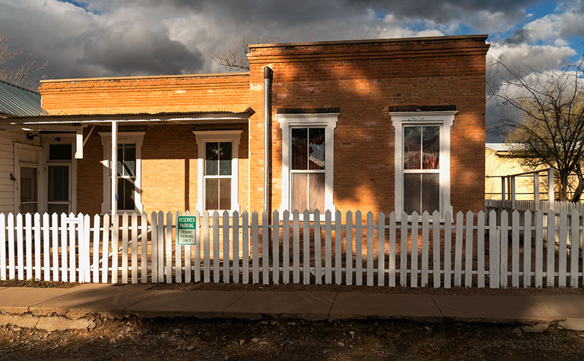
When I finished my loop, I was back at the starting point—in front of a red-brick home across the street from the courthouse. This century-old home doesn’t have a written story—well, not online, it doesn’t—but I want to know more. Who was it built for? Why was it converted into apartments? Where did they get all of those bricks?

I’m a sucker for picket fences. I would never own one because they’re a pain in the ass to maintain, but I can’t pass one without getting out my camera. I took two versions of this photo; the first was when I started my courthouse walk. In that one, the sky was overcast, and the building was entirely in its shadow. When I finished my lap, the clouds had partially opened, allowing the sun to shine light onto the apartments. This pattern of light and shadow is my favorite light. Here’s why: if you combine the way the building is lit and the broken clouds in the sky, this scene will never happen exactly again. That means I captured a specific moment that can never be reproduced. If you think about it, it’s a moment of history.

I called this shot White Pickets and Red Bricks because those are the essential elements that make up this image. You can see its larger version on its Webpage by clicking here. I hope you’ll join us next week when we come back with our final Tombstone image.

Till next time
jw

BTW:

I want to note this week’s passing of David Crosby, a founding member of two bands that were part of my formative years; the Byrds and Crosby, Stills, and Nash (and subsequent derivatives). They pioneered the transformation of folk music to folk rock. Several of David’s albums in my collection get regular rotation in my listening room. Peace-out David.

Motel Du Beau Picture of the Week

Motel Du Beau - This 1929 establishment was one of the first to cater to tourists driving those new-fangled motor carriages.
Motel Du Beau – This 1929 establishment was one of the first to cater to tourists driving those new-fangled motor carriages.

When Queen Anne and I spent a week in Flagstaff last month, our primary goal was heat relief, but I was confident that I could snap a few shots of historic buildings and signs to add to my Route 66 collection. In this journal, I’ve written several times about my experiences traveling the Mother Road as a kid, so I’ll spare you from repeating them. Instead, I must say that I was disappointed at how hard it was to find kitschy motel and dinner signs along the main street. More profitable strip malls and professional offices are rapidly replacing them. Interstate 40 travelers prefer the newer hotels on Butler Street, where the Little America Hotel is. Nobody drives 66 anymore—too many lights and too much traffic.

John Steinbeck’s novel The Grapes of Wrath, the depressing story of dust bowl migrants, searching for survival, didn’t make Route 66 famous. Nor did that fame come from my father’s generation, who—like the Joad family—moved en masse to California after World War II. It came when Angel Delgadillo—the Seligman barber—pitched a historic highway idea to the State of Arizona. When that designation came through, tons of beer-guts had a play-pen to gather and drive their car toys. We’re dying off now, and like the coals in your Webber Grill, that passion is dying with us.

Master photographers Ansel Adam and Minor White influenced how I photograph the world. Still, in 1975, the George Eastman House showed a photo exhibition called The New Topographics: Photographs of a Man-Altered Landscape. The show still floats between museums today. It was a collection of ten photographs made by ten photographers that were opposite the landscapes I embraced. It was heresy. The photos are stark images of industrial buildings and houses devoid of people. I didn’t even think some of the artists printed very well. But I did kind of like the ones John Schott did. His pictures were of Route 66 motels. You can see where this led.

Flagstaff Train Depot - Either this is new or I've been blind, but the coolest Route 66 sign that I saw was the train station's address.
Flagstaff Train Depot – Either this is new, or I’ve been blind, but the coolest Route 66 sign I saw was the train station’s address.

I’ve considered compiling a book of my Route 66 photos. I have several, but most are from Arizona, with a couple from California and New Mexico, but nothing east of Texas. If this horse hadn’t been flogged to death, I still could work on my own Mother Road project. Now that I’m retired, I have time. I figure a month on the road should do it. To do it properly, I’d have to drive a classic car—something from the ’50s or ’60s. However, it needs air-conditioning, cruise control, and a good stereo (I won’t put up with AM radio stations dropping out under bridges). My ultimate ride would be a red ’62 Corvette—like the one Buzz and Todd drove—but hold the whitewalls. I could haul my camera equipment behind it in a small aluminum trailer like the autocross guys lug their race tires. October is a perfect month for a road trip, so if anyone out there wants to be my Angel investor, let me know. You’d get all the bills, half of the proceed, and a free book out of the deal.

This week’s featured image is of a prominent Flagstaff landmark. It’s called Motel du Beau, and the subject is the sign. It’s one of three hotel signs towering above the city (can you guess what this month’s project is). With the Lowell Observatory on top of the hill, Flagstaff has adopted a dark-sky policy, so the zoning people would never allow these enormous signs in town. If they weren’t historical landmarks, the city would tear them down.

In the late 1920s, Albert Eugene Du Beau vacationed in northern Arizona and envisioned a new way to make money. Instead of building a multi-story building for railroad and train travelers to stay, why not create a place for people traveling in these new-fangled motor cars? So, he designed and built a single-story motor-hotel (later shortened to motel) to be convenient to unload and load their vehicles in 1929. His design featured a U-shaped layout with steam-heated garages (they burned down in a 1970s fire) and indoor toilets. He built his motor court adjacent to downtown’s main street, which was brilliant because, in time, the busy highway became Route 66. The Motel Du Beau was one of the pioneering businesses to use neon signs and elevate them on towers.

In today’s modern world, the Motel Du Beau still looks like a nice place to stay, with rooms starting at $75—a far cry from the original price of $2.50 per night. Their website shows various room types, and they have a lovely little wine lounge called Nomads. I’d certainly be willing to try it after they reopen the bar.

I hope you enjoy seeing a part of Flagstaff’s history. You can view my Motel Du Beau web version on its page by clicking here. Next week, we’ll look at another historic Flagstaff motel sign, so be sure to join us then.

Till next time
jw

Sinagua Pueblo Picture of the Week

Sinagua Pueblo - A two room stacked-stone ruin that the Sinagua people used for ceremonial purposes.
Sinagua Pueblo – A two-room stacked-stone ruin that the Sinagua people used for ceremonial purposes.

When Queen Anne and I married, we lived most of a decade in a second-floor condo. Besides living in cramped quarters, the thing we most disdained was lugging groceries from the parking lot and up those stairs. My right knee cracked with each step. We swore then that we’d never live in a two-story house.

The Sinagua people would’ve considered us Snowflakes. Imagine your family living in a small cave with a plastered rock façade built on the side of Walnut Canyon. They scaled the canyon walls (without stairs) to get to work. Once on top, the men tended small patches of fertile soil along the edge. They grew drought-resistant crops because their name means Without Water. At least, the Spanish called them that when they first visited the canyon. For protein, they hunted deer, elk, and big horn sheep. After butchering the game, they stuffed the meat into Safeway plastic bags and lowered it on ropes.

Given my extreme age, my most significant anxiety would be getting up in the middle of the night for a glass of Water. As it is, I struggle to find our kitchen in the dark, much less climb down to the creek and back. Of course, their local wise man was in his thirties, and he knew when to stand up and declare, “Today is a good day to die.” Then as he tossed his blanket over his shoulder, he’d tromp out of the camp to the nearest mountaintop, where he’d sit for weeks until dying of starvation. Once again, I’ve proved that exercise is unsuitable for you.

There are many disadvantages to living on a cliff-side cubby hole, but for me, it’s the TV reception. It’s lousy down there. You’d need to get cable or a satellite dish. Then you’d waste time waiting for the cable guy to show up.

There are two trails for you to explore when you visit Walnut Canyon National Monument. Both are under a mile long. The Island Trail is a loop that drops into the canyon, past several dwellings, and then climbs back to the rim. We’ll explore it next week. The Rim Trail stays on top of the mesa and is easier to hike. It goes past some old crop fields and a couple of ruins. I took this week’s picture on the Rim Trail.

The image that I call Sinagua Pueblo shows a two-room stone building of generous size. This structure was probably a communal building for ceremonies and grain storage, like your condo’s community center. Here is where the Sinagua unloaded their trucks after a Costco run. Surely you realize that I’m joking. Flagstaff doesn’t have a Costco. Recovered artifacts show that the Sinagua traded with the villages at Eldon Mountain, Wupatki, and Homolovi—after a short train ride to Winslow.

As you quietly stand and admire the pueblo’s stonework, you can hear Sinagua ghosts laughing, smoking peyote, and chanting with the rhythm of deerskin drums late into the night—until the neighbors come by and yell, “turn down those damn drums.” More cowbell.

I hope you enjoy seeing the pueblo at Walnut Canyon. You can view the Web version of Sinagua Pueblo on its page by clicking here. Next week, we’ll explore the Island Trail and show those photos—if I can only make it up this last flight of stairs.

Till next time
jw

Tulip Rock Picture of the Week

Tulip Rock - A formation that I passed on the Grotto Trail that looks like a tulip to me.
Tulip Rock – A formation I passed on the Grotto Trail that looks like a tulip to me.

One of my loyal readers commented that she couldn’t see the rock creatures like me. If you’re like her, that’s ok. Maybe your mind isn’t wound up like mine, or you’re not on the same prescriptions. Whatever the difference is, I’m simply trying to show you the world as I see it.

This week, I have another Rorschach test for you. It’s a picture of a second remarkable formation I found while hiking the Grotto Trail. I call it Tulip Rock because I think it looks like a flower. It could be a rosebud, a daisy, or a dew-covered morning poppy. Don’t see it? As long as you don’t see the Prince of Darkness who’s come to cast humanity into eternal damnation, you’re alright. If that were the case, I’d suggest you consider a change of meds.

When I composed this image, I wanted to show a couple of things. The first is that most of the hoodoos in Chiricahua don’t look like sculptures; they’re ordinary. That uniqueness makes the formations like this and last week even more special. I found two examples (there are more) on my short hike on the Grotto Trail. Imagine the images I’d have if I had visited the Chiricahuas as a younger man.

The other thing that I wanted to show is the background. The higher peaks of this range are along the horizon, including the 9700-foot Chiricahua Peak. As you can see in this image taken in late March, they are still snow-covered. They’re part of the Coronado National Forest—sometimes called the Sky Islands. The forest isn’t contiguous—it includes several southeastern ranges separated by broad basins. I’m not aware of another forest like it in the United States. Feel free to correct me if I’m wrong.

You can see a larger version of Tulip Rock on its Web Page by clicking here. Come back next week when we finally make it to the Grotto—a four-pillar room with a rock roof.

Jeff Goggin

It’s painful to type these words. Jeff Goggin—the other half of the Ballast Brothers Racing Team—died Thursday a week ago (7 April 2022). He was the last surviving family member and lived alone in the family’s Scottsdale home. Jeff’s mother lost a long degenerative battle with Lou Gehrig’s disease. It’s still untreatable. Several years ago, he told me that he was starting to show the same symptoms. Being the insanely practical man we knew, he ended his life to spare himself further suffering while he could still make his own decisions. Jeff is survived by his estranged partner, Paula Hoff.

Jeff was a brilliant, caring, funny man who loved good music, sick jokes, fast cars, fine art, a good scotch, and pretty women. Queen Anne and I miss the jerk.

Till Next Time

jw

Organ Pipes Picture of the Week

Organ Pipes - One of the first features you see after entering the park is the Organ Pipe Formation.
Organ Pipes – One of the first features you see after entering the park is the Organ Pipe Formation.

Two days have passed since April Fool’s day on Friday. That morning, Queen Anne stopped by my office door and announced, “I’m pregnant.” She’s a one-trick pony because she’s recycled that joke every year that we’ve been married, so I ignored her. However, Friday was an important milestone for me, and since I’ve waited two days, you know I’m not pulling your leg. Friday marks the 50th year since I moved to Arizona. I think that officially makes me overqualified to be a native.

With the month’s change, we’re starting a new project. April Fool’s—we’re not leaving Willcox. I’m just going to show you why we actually traveled to Cochise County and what we did with our afternoons. You’ll recall that I spent mornings in Willcox searching for a decent cup of coffee and shooting the town’s historic buildings. After an hour or so—when the light became too harsh—when I returned to our motel and opened the door, Queen Anne sat on the bed corner bejeweled and makeup finished. “I’m ready for breakfast,” she’d say—who am I kidding? That would never happen. The truth is that I could hear her lyrical voice waft from the bathroom, “I’ll be ready in a minute.” In husband-speak, that phrase meant that I had time for a nap.

The actual purpose of our Willcox visit was to photograph the Chiricahua National Monument. After fifty years of living in Arizona, this was my first visit. It’s usually a half-hour drive southeast of Willcox. Still, we dawdled with a camera and stretched the trip to over an hour. The scenery along County Road 186 reminded me of California’s central valley and the Sierra Nevada foothills. Long butterscotch colored grass filled the broad Sulphur Springs Valley between the Dos Cabezas Mountains (Two Heads in English) on our east to the Dragoons on our west. Arizona ranges don’t tower over its valleys as the Sierra’s do, but at least the air was clear, and we could see all of the mountains.

My After Life - I found out that I can become a rural mail carrier in Cochise County even after I'm dead. That gives me something to do after I'm gone.
My After Life – I learned that I could become a rural mail carrier in Cochise County even after I’m dead. That gives me something to do after I’m gone.

On one of the many photo stops that we made, I was able to chat with the local postal carrier and got some great news. He told me that I don’t have to be useless after my death because I can always get a job delivering mail for eternity. You saw my after-life job delivering mail if you watched Funny Farmthe movie. All I have to do to qualify is pass the Civil Service Exam.

The route coming out of Willcox ends at the Junction of county roads 186 and 181, and you turn east on the latter. You pass from open range into a canyon as you head into the Chiricahuas. Within four miles, there’s a pay station. It’s closed due to the pandemic, so the Rangers collect any fees at the visitor’s center. Immediately on the right is a small family cemetery where the Erickson’s rest under shady oak trees. The Erickson’s are the family that homesteaded here after he retired from the Army at Fort Bowie. They established a ranch along Bonita Creek called Faraway Ranch because it’s far away from anything. Their daughter, Lillian, and her husband, Ed Riggs, welcomed guests to the homestead to promote tourism. They built many of the trails still in use, allowing visitors to wander among the unusual columns of eroded stone.

There’s only a single road in the monument that runs from the entrance, past the visitor’s center, climbs through Bonita Creek Canyon, and winds along the ridge of the park’s eastern boundary. Along its length, there are numerous stops, pull-outs, and parking areas where you can stop and take in the view, like this week’s picture that I call Organ Pipes. However, if you want to immerse yourself in the complete gestalt, you should plan on hiking one of the trails. They range from a half-mile to a couple of miles long. You can also link several trails and make your feet suffer to your heat’s delight.

Chiricahua National Monument only has one small campground, which fills quickly—especially during the season. There are only two towns with hotels, Willcox along Interstate 10 and Douglas at the Mexican border if you’re willing to drive further.

The Organ Pipe Formation captured in this week’s image is one of the first displays after the visitor’s center. The columns rise several hundred feet above Bonita Creek and are mirrored on the other side of the road by similar rocks. There wasn’t a way for me to hike above the trees to get a better shot. This picture does not do justice to their scale.

You can see a larger version of Organ Pipes on its Web Page by clicking here. Next week we will hike one of the short trails to look at the park’s natural sculptures. Come back to see what we found.

Until next time — jw


Past and Future Picture of the Week

Past and Future - Along Willcox's historic Railroad Avenue, there are business that pay homage to the town's past and its future.
Past and Future – Along Willcox’s historic Railroad Avenue, some businesses pay homage to the town’s past and others to its future.

My dad bought our first television the week they hit the stores from stories that my mom told. I don’t remember because I was an infant at the time. The screen was small; you could cover it with your hand. She said that news of our new set spread fast, and the entire neighborhood crowded into our two-room apartment to watch shows on it. The crowd size amazes me because my great-grandmother’s apartment building didn’t have indoor plumbing, but it must have had electricity.

We didn’t need a TV Guide. We memorized the program schedule and could rattle off the shows for any given evening. The best night was Sunday. That was the night that Walt Disney’s Disneyland came on. They called it that between 1954 and 1958, it had various names after that. The gist of the show was always the same. Us kids loved that we could stay up an extra hour to see it—and maybe some of the Ed Sullivan Show if Topo Gigio was a guest.

The Disney show had four rotating themes. My siblings and I liked the cartoon week the best, but my dad enjoyed the westerns. They were either cowboy stories or a smooth-talking narrator explaining the west. He spoke differently from us. He didn’t have an accent as such—he had a drawl. He hung on to words so long they curled at the end—like the top of a Dairy Queen cone. His calm voice was soothing, and even at our young age, we knew that he wasn’t from Pittsburgh.

As I got older, I learned that the narrator’s name was Rex Allen. In addition to the Disney shows, he was an actor, songwriter, and singing cowboy. You may remember seeing his movies on Saturday morning cowboy shows if you’re as old as I am. (I don’t see a lot of hands out there in the peanut gallery, so you’ll have to take my word for it.)

After seeing this week’s picture, many of you have already guessed that he was born and raised in Willcox. I suspect that he’s their most famous native, and that’s why there is a museum for him along Railroad Avenue, across the street from a park with his statue. I can’t imagine anyone loitering in that park because the busy railroad tracks bisect it. It’s no place for a drunken hobo.

The tan building in the photo wasn’t built to house the Rex Allen Museum—it was initially the Schley Saloon. Sound familiar? It was the bar where Joseph Schwertner made his money—go back a read last week’s story. Two doors down, the building with the blue awnings is the Marty Robbins Gift Shop. You’re asking, “What’s he got to do with Willcox?” If you’re a boomer like me, you’ll remember the hit song Streets of Laredo that Robbins sang. Rex Allen wrote it. I think another Allen song that Arthur Godfrey recorded in 1948 is pretty catchy. It’s titled Slap Her Down Again Paw. It’s true; I couldn’t make this one up.

The grand white building between the museum and gift shop was a bank. It’s currently the Keeling Schaefer wine tasting room. One of at least three that Queen Anne and I saw on the avenue, and they may be the future of Willcox tourism. While the memory of Rex Allen and Marty Robbins appeals to my generation, there is no context for those that follow. So, the old cowboys’ draw may be on the wane.

However, wine is another story. A couple of decades ago, some adventurous vintners settled into the high grasslands of southeast Arizona. They saw that the conditions here would be an excellent place to plant vines—especially the well-drained soils of the foothills. The climate and geography are similar to parts of California’s central valley. New wineries are blooming from the little town of Elgin east to New Mexico.

Anne and I spent a couple of hours in Keeling Schaefer sampling and talking with the hostess. We found their offerings to be young and a little rough, but we did like a couple of whites and reds enough to purchase. There is an essence of the local soil in the wine—like the peat in a highland scotch. It’s a characteristic that you like or not. A word of advice if you go; sample at the tasting rooms and note your likes. Then stop at Safeway and buy the bottles at a more reasonable price.

You can see a larger version of Past and Future on its Web Page by clicking here. Next week we move on to a new project. Come back and see our next project.

Until next time — jw

Bitter Creek Saguaros Picture of the Week

Queen Anne and I spent yesterday changing the house calendars, and with a new month, it’s time for a new photo project. I’ve been struggling to come up with an ongoing long-term theme—something similar to last years where we took you from town to town within Yavapai County. I considered several options—all of which I crossed off because they involved exercise and the possibility of having my mug broadcast on a Silver Alert.

To find inspiration, as I frequently do, I grabbed my Arizona Gazetteer Map, went into the library, and scoured through it until my legs fell asleep. In the maps, I saw something that would be interesting as a basis for a long term project. I noticed that there are roads—secondary unpaved roads—all over the state. They’re like the ones around my neighborhood that are well graded and can be traveled in ordinary sedans (in dry weather). For Archie—my four-wheel SUV—they’re freeways. These back-roads go to places I’ve never seen, and because they’re not meant for speed, almost all of you haven’t been on them either. Some of them are dead ends, some lead up into the mountains, and some head off across the desert. Haven’t you ever drive past some side road and think, “I wonder where that goes?”

So, that’s what I plan to take on for a while. I’ll pick a back road and see if it leads to something pretty or novel. Maybe I’ll eventually collect enough material and produce a catalog or magazine of sorts, but I’ll worry about that later. I can always suspend this project when I come across something fresh or different. You might say that this blog, newsletter, or whatever you want to call it, is going from On the Road to Off the Beaten Path.

Conveniently, I had a head start, because a couple of weeks ago, I took my camera and headed up Castle Hot Springs Road. It’s the long way between Lake Pleasant and Morristown, and the only way you can get to the newly reopened Castle Hot Springs Resort where Clark Gable stayed (we’ll talk more about that in another post). The road winds its way through the Wickenburg Range, Buckhorn Range, around the Hell’s Gate Wilderness, and past several working ranches, so there’s lots of eye-candy along the way.

Large saguaros march up the side of an unnamed mountain.
Bitter Creek Saguaros–Large saguaros march up the side of an unnamed mountain.

This week’s featured image comes from the area where the road runs through Bitter Creek. The 3700’ mountain is unnamed, and I was struck at how the saguaros grew thick along its flank to the top. At the base of the mountain’s north side, there is a ranch labeled 11 L on my topo map and a water hole named Layton Tank. I like how the vertical cacti resemble the crowds climbing Mt. Everest we’ve seen in the news lately. I’m also pleased that the clouds parted enough to add texture to the sky. I called this image Bitter Creek Saguaros.

You can see a larger version of Bitter Creek Saguaros on its Web Page by clicking here. Be sure to come back next week when we’ll see another beautiful scene I shot on my Castle Hot Spring Road outing.

Until next time — jw