Fish-Hook Barrel Cactus Picture of the Week

When you hear someone talk about a desert, what image pops into your mind? Is it the endless Sahara dunes where Bedouins in keffiyeh headdress travel by camels? Maybe it’s the barren, dry lakes of Death Valley, or perhaps your go-to desert is in Mongolia. By definition, a desert is any place receiving less than 20 inches of annual precipitation. That makes most of the Great Plains, most of Southern California, and the Antarctic deserts.

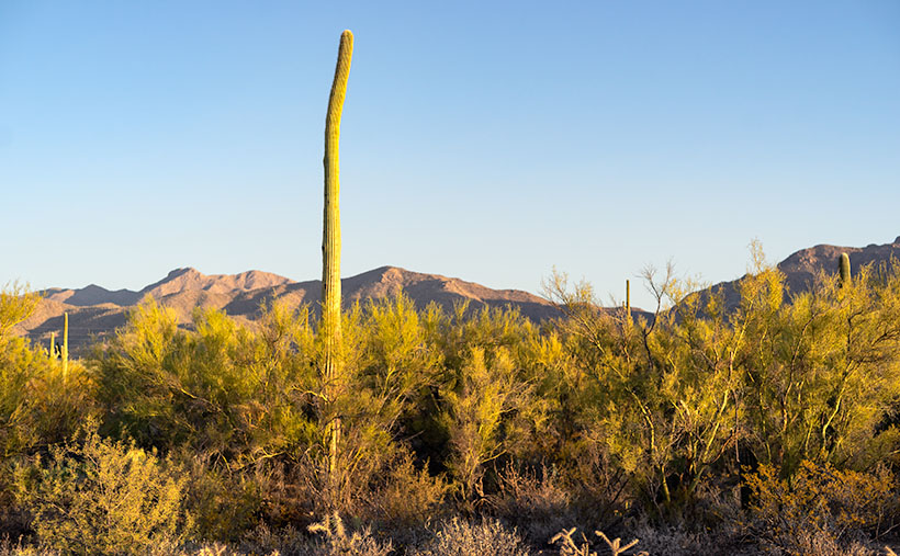
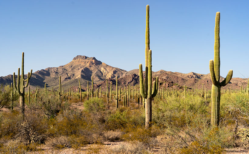
My desert is the one that I’ve called home for almost 50 years; the Sonoran Desert. In the last half-century, I’ve traveled most of its parts within Arizona and California. I can attest that it’s not a flat, uniform wasteland—as some people think. It has mountains, canyons, plains, dry washes, and an exotic river or two. Its span ranges between Arizona and the Mexican State of Sonora. If you see a map of it (and you have to squint real hard), it’s jellyfish shaped—starting at the north (where I live), the half-circle body covers Arizona, and the tentacles reach south to either side of the Sea of Cortez. Its width covers from El Centro to Tucson.

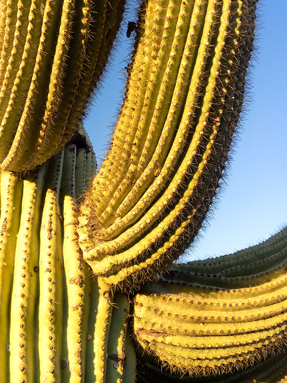
The signpost that says, “This is the Sonoran Desert,” is the saguaro cactus. It thrives here because of the four major western deserts; the Sonoran is the only one with two rainy seasons; winter rains and summer monsoons. In winter, the rains nourish the cactus to flower and bloom, while the monsoons provide water for the dispersed seeds to germinate. Isn’t nature swell?

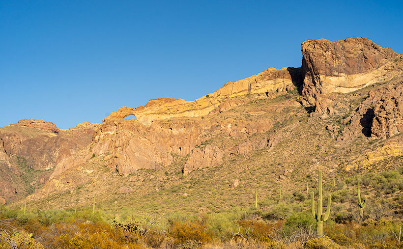
Although the saguaro may be the Sonora’s big-ticket item, it isn’t the only thing here to see. That’s evident when you visit the desert’s reserves like Saguaro National Park, Organ Pipe Cactus National Monument, KOFA Wildlife Preserve, or several wilderness areas in southern Arizona. The biodiversity of these places will keep you on your toes—“Watch out! There’s a snake over there.”

Fish-hook Barrel Cactus - a couple of succulents nuzzle in the late afternoon sun.
Fish-hook Barrel Cactus – a couple of succulents nuzzle in the late afternoon sun.

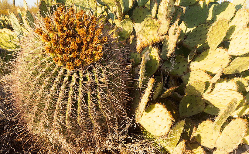
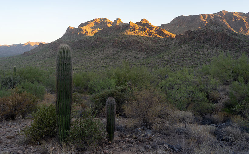
That’s how I thought I’d end our one-day tour of Saguaro National Park. While exploring the park’s dirt road loop, I spotted a couple of succulents nuzzling one another, so I went in and grabbed a shot. I call this picture Fish-hook Barrel Cactus. It shows a couple of common cacti—a fish-hook barrel and prickly pear—glowing in the evening sun. The barrel cactus is the one you’re supposed to cut open if you need water—it’s not hollow, so you have to wring the pulp if you’re desperate for a bad tasting drink. Prickly Pear grows everywhere and has even overrun Australia after it was illegally transplanted there.

You can see a larger version of Fish-hook on its Web Page by clicking here. For December, we have an idea for a completely different type of monthly project. We had to. I’ll be spending time with my Mexican dentist—oh joy—and Anne is risking her life to visit her family. She’s shortening my leash while she’s away, so I won’t be able to roam very far from home. If I do, my electronic collar will shock me.

Until next time — jw

Get Bent Picture of the Week

Not all saguaros are super-models. Like people, they come with all sorts of warts and scars. The Gila woodpeckers carve nests in them because inside the flesh, the summer daytime temperatures can be over thirty degrees cooler than outside. The cavities don’t cause harm to the saguaro, and squatters like hawks, owls, and other birds move in after the woodpeckers leave. The substantial threats to a saguaro’s life are from lightning, strong winds, stupid people, but the real culprit is frost.

On our imaginary day-trip around Saguaro National Park, we’ve left behind the visitor center, and we’re exploring the Bajada Wash Loop, which leads from the west side up toward the Tucson Mountains—the park’s backbone. In fact, these are the only roads into the interior. Countless trails crisscross the park, and they appear to be the preferred method of exploring the backcountry. I’ll leave that mode of transportation to people younger and more agile than me.

Get Bent - A frost damaged saguaro rises above a thicket of palo verde before the Tucson Mountains.
Get Bent – A frost-damaged saguaro rises above a thicket of palo verde before the Tucson Mountains.

The afternoon was getting late when we reach the top of the loop. The shadows were already long as I looked for a shot of the range’s high peaks. I stopped the truck when I spotted an interesting cactus. It rose maybe thirty-feet above the top of a palo verde thicket, and it had a bent trunk. I guessed the deformity was the result of a freeze. It’s a young specimen—if you can consider thirty-years young—to have damage like this, but the Tucson Basin is a thousand-feet higher than Phoenix, and we were near the top of the loop, which is 500-600 feet above the city. That’s near the limits of the saguaro’s range because winter nights often get below freezing up here.

After I processed this shot and began pouring over area maps,  I realized that I also captured another landmark in it—actually two of them. To the saguaro’s left are two peaks on the horizon. The taller of them is Wasson Peak (4639′), and the other is Amole Peak (4386′). They are the two highest points within the park’s boundaries. So, this week you get a BOGO.

You can see a larger version of Get Bent on its Web Page by clicking here. Next week, our day in Saguaro National Park comes to an end, so be sure to come back and see what we found.

BTW: Queen Anne and I wish you a very safe and happy Thanksgiving. We’ll be spending the day at home enjoying store-bought leftovers. You know, the usual turkey, stuffing, mashed potatoes swimming in gravy, cranberry sauce molded in the shape of a can, and buttermilk pie topped with fruit and whipped cream. I’ll see you next week if I can get up from the couch.

Until next time — jw

Arm Pits Picture of the Week

When we visit national parks, Queen Anne and I like to spend time at the visitor’s center. We study the 3D display map and look through all the books. It gives us an idea of what to expect. Unfortunately, one of the regrettable effects that COVID 19 has brought is that the centers are closed. Even so, we stopped at the one in Saguaro National Park because they leave literature outside for crazy folks like us. That’s where the story of this week’s picture begins.

After picking up a map, I wandered the grounds looking for a shot of the mountains outback. I took several shots, but I knew they weren’t keepers. We got back in the truck, intending to explore the open roads, but we never left the parking lot. I spotted a possibility and immediately parked. As I hiked up the hill, I spotted a unique saguaro, and I forgot all about what I was after. Ooh, squirrel.

Arm Pits - A close-up photo of a cactus that refused to shave found in Saguaro National Park, Arizona.
Arm Pits – A close-up photo of a cactus that refused to shave found in Saguaro National Park, Arizona.

Like people, saguaros are all different. Young ones have no arms; some have one arm, others two or more. Someone could publish a book of saguaro portraits—it’s probably already done. The specimen that caught my eye had multiple arms, and they were pretty much at the same level. It reminded me of the Hindu goddess Durga—the woman seated with a gold headdress and many arms. As I approached the cactus, I noticed that it hadn’t been marred with woodpecker holes, so I spent some time trying to get a memorable photograph.

When I first reviewed this shot on my computer, I came up with a litany of Queen Anne jokes about shaving her legs. They involved ruined pantyhose, scratching posts, bear fur, velcro, and things along those lines. But, this morning, I thought better and decided not to go there. It’s better not to squander what little life I have left. I didn’t want to let the humor go to waste, though, so I titled this shot Arm Pits.

You can see a larger version of Arm Pits on its Web Page by clicking here. Next week, our day in Saguaro National Park turns to late afternoon, so be sure to come back and see what we found.

Until next time — jw

Tucson Mountains Sunrise Picture of the Week

I woke up in a very chipper mood this morning. When I put on my jeans, they were so loose that I had to tighten my belt a notch to make things better. My morning routine is to check my vitals before making coffee, and my blood pressure was perfect today. There’s been a great weight lifted off my shoulders, and let me tell you what I think it is. First of all, I finally finished the wood project that’s kept me busy all summer—I’ll show you on Wednesday—and secondly, summer’s finally over—well I hope it is.

Over the past couple of days, clouds have filled the Congress skies, and it sprinkled Friday evening. That’s the first precipitation in months. This morning, our new wall thermometer got below 40º for the first time, and I got to put on one of my bulky sweaters. It keeps getting better—today’s forecast is for snow in the mountains. Yep, straight from summer to winter. Today, the world is better.

My mood is so good; I don’t have any snarky stories about Queen Anne, so let’s go back down to Tucson and see where we stopped for our second November image. Last week, we visited the overlook at the top of Gates Pass before dawn. Believe it or not, I wasn’t the only photographer there. A handful of guys were hanging out with their tripods set up for a sunrise shot when I got there. I’m not usually late to one of these parties, and when I saw what they were getting ready to shoot, I wasn’t impressed—it was more of a sundown kind of shot. After snapping a few other scenes, I hopped in the truck and headed down the road stopping again at the bottom of the pass.

Tucson Mountain Sunrise - The morning sun shines on top of the Tucson Mountains.
Tucson Mountain Sunrise – The morning sun shines on top of the Tucson Mountains.

In this week’s featured image—that I call Tucson Mountain Sunrise—we’re looking back at the overlook. It’s the flat area between the two forward peaks at the bottom of the sunlight. Behind that, you might recognize Bushmaster Peak from last week’s image. Actually, all of it is Bushmaster Peak, but I really liked the western side’s gnarly part. It has the most character. For scale, I found a couple of young saguaros and placed them in the foreground—that means that I was wandering around in the dark, rocky, snake-infested desert to get this shot just for you.

How could you ruin a beautifully quiet moment like this? Well, let me tell you how. Just as I finished my shot and began walking back to R-chee, a guy who was parked nearby in a black late-model Chevy pick-up fired it up, and the distinct sound of a V8 with open headers reverberated throughout the canyon. Now, I enjoy loud race cars as much as anybody, but it has to be in the right context. As this gentleman drove east through the pass, it was obvious that he wasn’t racing—he was making noise just for the sake of noise. Fortunately, after the summit, he rode the brakes downhill, and the bird songs once again filled the morning air.

You can see a larger version of Tucson Mountain Sunrise on its Web Page by clicking here. Next week, we’ll make a morning stop in Saguaro National Park for another photograph in our story.

Until next time — jw

Arch Canyon Picture of the Week

Organ Pipe Cactus National Monument has two vehicle loops that allow visitors to explore the park beyond the visitor center. On the west side of Highway 85 is the Puerto Blanco Drive, which is over 40 miles long and has stretches that require four-wheel drive. East of the highway is the Ajo Mountain Loop Drive, which is half the length and can be navigated in your family sedan (in good weather). Since I was only there for an afternoon, I opted to take the latter route.

I suppose if you didn’t stop to look at anything, you could follow this route through the Ajo Mountain Foothills in less than an hour traveling at the posted speed, but I spent more than three hours on the 19-mile loop because I was constantly hopping out of the truck taking pictures and gawking. In all that time, not once did I see another person—not even a ranger.

The road heads north-ish along the foothills’ west flank from the visitor’s center until it climbs over a pass at Arch Canyon. Then the road returns south through a valley between Ajo Mountain and its foothills. This week’s featured image was taken at the trail’s high point at Arch Canyon. There I was surprised to discover—an arch! Who knew? And it’s a good-sized one. I don’t recall seeing it in any of the park’s brochures, which I find odd.

Arch Canyon - At the north end of the Ajo Mountain Loop, you'll find the picnic grounds at Arch Canyon with an unnamed arch overlooking the area.
Arch Canyon – At the north end of the Ajo Mountain Loop, you’ll find the picnic grounds at Arch Canyon with an unnamed arch overlooking the area.

The arch doesn’t have a name on my topo maps. They only note the location of the natural arch. Maybe I could petition them to call it Queen Anne Arch. If the park service did that, maybe I could get her butt in the truck to see it. There is also a picnic area and campgrounds in Arch Canyon, but only tents are allowed. I guess that’s good because the camp would be packed with motor homes and fifth-wheels all year long.

This would have been a perfect opportunity to fly my drone so that I could get a shot that was closer and from a higher perspective. Alas—there’s a double drone prohibition in place here. Drones are not permitted to fly in National Park or National Monument airspace (although winged RC airplanes are permitted). Also, most of the Organ Pipe Cactus National Monument is designated as a wilderness area. Only a dozen yards on either side of the roads are the exception. All motorized vehicles are banned from wilderness areas.

While I was in the picnic area, I took some time to read the wonderful signs that the Park Service puts up to explain the views. I learned something that I’ve wondered about for years. The Ajo Mountain Range is part of the much larger ancient Pinacate volcanic field covering more than 1,900 square miles. The Pinacate Mountains are south of the border, about halfway to the Sea of Cortez. Over eons, this field had violent eruptions that spewed tons of magma, and alternately it had periods where the volcanoes spit out tons of ash and relatively little lava.

You can see a streak of light-colored rock near the ridge’s top in this week’s image. The darker rock is our old friend Rhyolite, the slow-moving magma found in the KOFA Range. The lighter streaks are from the ash falling from the sky and covering the ground. The ash layer is called Tuff, and I’ve seen it throughout Arizona—(and that’s the rest of the story, g’day – as Paul Harvey used to say).

You can see a larger version of Arch Canyon on its Web Page by clicking here. Come back next week to see the down hillside of the Ajo Mountain Loop.

Until next time — jw

Ajo Mountain Picture of the Week

I turned my calendar over this week, and that means a couple of things to me; the best is that it’s the final quarter of 2020. In an average year, the hot weather finally breaks in a couple of weeks, because there’s an Arizona law that prohibits kids from Trick-or-Treating on a hot night. Of course, nothing about this year has been normal, so I’m not holding my breath. The Queen and I are looking forward to opening the house soon, and I’m anxious to take my drone out again and resume filming.

For October’s project, I drove south into the heart of the Sonoran Desert. As I said, we live along the northern edge of the saguaro country. We have a good population here in Congress and Wickenburg, but in other parts of the state, the giant cactus thrives. To show you, I traveled south of Ajo last week and drove the Ajo Mountain Drive loop in the Organ Pipe Cactus National Monument. The road is unpaved, but a sedan will make it as long as it’s not raining.

A couple of years ago, Anne and I visited the monument for the first time. I wanted to take this loop, but we didn’t bring an off-road truck. Plus, when she saw a sign warning of smugglers and illegal aliens, she said no. The park is 10 miles from the Mexican border, and 30 miles south of the old copper mining town of Ajo (evidently the Spanish found wild garlic growing in the area, so that’s how it got the name). The road passes through the middle of the Goldwater Bombing Range, so I’d recommend not stopping along the way to pick wildflowers.

The Monument is the only place where you can see large stands of Organ Pipe Cactus. They’re more common south of the border, but on this side—not so much. The two columnar cacti (saguaro and organ pipe) grow side-by-side throughout the park. With the dry summer that we’ve had this year, I was pleased to see that the specimens in the monument looked healthy and watered. The rain patterns in lower Pima County are different from home, and they had a better monsoon than we did. The cacti are packed in down there—if you could ever call a desert lush, Organ Pipe would be an example.

Ajo Mountain - The volcanic peak rises above its foothills in the Organ Pipe Cactus National Monument.
Ajo Mountain – The volcanic peak rises above its foothills in the Organ Pipe Cactus National Monument.

Ajo Mountain is the name of this week’s featured image, and in it, I was trying to show two things. They are the volcanic mountain—rising above its surrounding foothills—and how many saguaros are growing per square mile. These giants also seem significantly taller than our home-boys.

You can see a larger version of Ajo Mountain on its Web Page by clicking here. Next week we’ll stop further along the drive and show you the organ pipe cactus from which the monument gets its name.

Until next time — jw