Organ Pipe Cactus Picture of the Week

There’s nothing rare or unusual about the organ pipe cactus. They’re a common sight in the Mexican states of Sonora and Baja. I’m sure that the local folks view them the way Zonies do the saguaro; they’re just another part of the local landscape. But, the saguaro’s smaller cousin only reaches into the United States in the national monument that’s a half-hour south of Ajo, and that’s what makes them special to us.

Like the saguaro, the organ pipe grows best on south-facing rocky slopes of the Sonoran Desert. So why don’t they grow further north? Well, that’s because they’re less tolerant of frost and won’t survive a hard freeze. The specimens that we have in our cactus garden have to wear styrofoam cup hats to get through even our mild winter nights.

Another difference between the columnar cacti is obvious by looking at them. The giant saguaro grows with a single trunk and sprouts arms after it reaches 50 years—like a tree. On the other hand, the organ pipe’s arms sprout from a stem close to the ground resembling a bush. Internally, their structures are similar to porous skeletons that allow the flesh to expand and store water.

While the saguaro and organ pipe’s flower looks the same, the latter’s are only open at night and are pollinated by bats. The saguaro keeps its flowers open in the day, which lets bees and doves help the pollination. Like the saguaro, the organ pipes produce fruit during the rainy season about a tennis ball’s size. The flesh is bright red and supposedly tastes better than watermelon. After eating the sticky fruit, birds disperse the seeds by defecating from the branches of palo verde trees.

Organ Pipe Cactus - This cactus specimen commonly grows in the Mexican states of Sonora and Baja, but only crosses the border within the boundaries the Organ Pipe Cactus National Monument.
Organ Pipe Cactus – This cactus specimen commonly grows in the Mexican states of Sonora and Baja, but only crosses the border within the boundaries of the Organ Pipe Cactus National Monument.

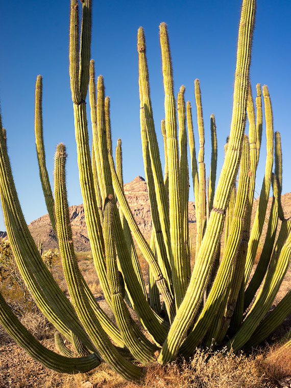
I drove a good distance on the Ajo Mountain Loop looking for a really nice organ pipe to photograph for this week’s featured image. The specimen in my image—called Organ Pipe Cactus—is a beaut, resembling an upside-down octopus on steroids. I’m a little upset that Ajo Mountain snuck in and photo-bombed my picture. At least you can see how far I traveled by how the mountain’s angel changed from last week’s photo. My references say that an organ pipe’s normal height is 10 to 16 feet, but this baby towered over my head and may have reached 20.

You can see a larger version of Organ Pipe Cactus on its Web Page by clicking here. Next week’s stop resulted in a surprise photo op. Be sure you come back and see what I found.

Until next time — jw

White Barn Picture of the Week

I’ve been left home alone for almost a week now. Queen Anne had to fly halfway across the country to drag her friend back to the proper side of the Continental Divide. I keep telling you folks that nothing good ever happens on the other side of those mountains. She’s my editor, so if you find grammatical errors in this issue, you can blame her. Before she left, I told her that if she weren’t here, she wouldn’t get any press, so I’m not going even to mention her this week. It’s funny how you don’t understand how much you rely on someone until they’re gone. I miss her a lot—the sink is full of dishes, and I’m out of socks.

Smoky Sky - During the past few weeks, we've had atmospheric effects from the California fires. That smoke has drifted over our state and turned the sky white and given us red sunrises and sunsets.
Smoky Sky – During the past few weeks, we’ve had atmospheric effects from the California fires. That smoke has drifted over our state and turned the sky white and given us red sunrises and sunsets.

Another off-topic thing that I want to mention is how much the California fire smoke is making photography challenging. There’s a strange color cast, and it looks like it’s cloudy. The other morning, while I was riding my bike at sunrise, the sun was deep orange as it cleared the horizon. I grabbed my camera when I got home and tried to get that color on film. By the time I set up, the sun’s deep color had faded. You can see in this shot that the sun is exposed correctly, yet so are the houses. On a regular morning, that range of exposure would be more than my camera can record so that the buildings would be black from underexposure. You can’t escape the haze either. I was in Ajo this week, and the atmosphere was hazy there too.

Now, where were we—oh right, driving General Crook’s trail. In last week’s episode, we stopped at 13 Mile Butte, which is about halfway up the grade out of the Verde River Valley. The climb isn’t as bad as some other routes to the rim, and if I intend to head east on Interstate 40, I usually go this way to get to Winslow. It cuts off a couple of miles, the grade is better than going to Flagstaff, and there’s less traffic. Once you’re on top of the rim, the road runs straight and flat.

White Barn - On a ranch near the edge of the Mogollon Rim, they are building a new barn. Still in its white Tyvek wrapping, it stood out like a jewel on the prairie.
White Barn – On a ranch near the edge of the Mogollon Rim, they are building a new barn. Still, in its white Tyvek wrapping, it stood out like a jewel on the prairie.

I took this week’s featured image shortly after we reached the plateau. On the south side, I spotted a ranch with a building under construction—maybe a barn. I don’t think it’s supposed to end up white. It was wrapped in the Tyvek moisture barrier and didn’t have siding yet. But, it gleamed in the sun well enough for me to stop the truck for a photo. It gives scale to the scene. I also liked how you can see the edge of the Mogollon Rim behind the building as it undulates across Arizona. I called this photo White Barn.

In The Pines - Once the General Crook Trail reaches the elevation of 7,000', it is surrounded by our countries largest contiguous Ponderosa Pine forest.
In The Pines – Once the General Crook Trail reaches the elevation of 7,000′, it is surrounded by our countries largest contiguous Ponderosa Pine forest.

Since we don’t have a fifth Sunday this month, I’m including an extra photo, at no additional charge. I took this shot the road after Crook’s Trail enters the pine forest. When easterners think of Arizona, this is not the image that comes to mind. They believe we are one big desert with a great big ditch in the middle. But, this Ponderosa Pine forest is the largest contiguous stand in the country. It stretches across the state and into New Mexico. The plateau ranges from 7,000 to 9,000 feet, with a couple of 12,000 peaks on it. In summers, smart (or rich) Phoenicians either escape to San Diego or they have summer cabins up here. You can see why.

You can see a larger version of White Barn on its Web Page by clicking here. Next week we’ll begin a new journey somewhere in Arizona, so y’all come back and join us, ya hear? (Gawd, now I’m talking like the queen.)

Until next time — jw

Parade Grounds Picture of the Week

We Arizonans have it easy these days. Within a matter of hours, we can drive from the beaches of Yuma to the Flagstaff snowfields. We’re able to do that because of our modern cars and roads. With their bridges and gentle slopes, we forget how rugged our State’s terrain is. We sit in our air-conditioned cocoons and watch the scenery pass, without having to wonder, “How the hell am I going to get over that?” And the closest we ever come to getting scalped is from the guy selling souvenirs at The Thing.

Arizona was a different place when Martha Summerhayes arrived at Ehrenburg Landing via paddle-wheel steamer in the summer of 1874. She accompanied her husband—Jack, a Lieutenant—when the Army assigned him to the territory. She writes in her now-famous book—Vanished Arizona, Recollections of the Army Life of a New England Woman—about their travels to posts within our state, including her story of being the first woman to travel the subject of this month’s photo essay—The General Crook Trail.

George Crook was a Civil War officer who was assigned to Arizona to put a stop to Apache raids. Now, I fully appreciate the new awakening in our country about racial injustice, but that’s not the point of my story. I’m merely trying to explain, in my words, the trail’s history. George’s job of managing the Apaches wasn’t easy. They’re not a single people. There are the Chiricahuas, Yavapai, Mescalero, Tonto, and several more in Arizona alone. The tribe’s traditional homes were spread along the Mogollon Rim—the southern escarpment of the Colorado Plateau that slashes across the midsection of our state. It was like playing Whack-A-Mole; he’d quash one uprising only to have another pop-up 50 miles away. It didn’t take long for General Crook to understand that he had a logistics problem. He needed to move troops and supplies quickly from Fort Whipple (Prescott) to Camp Verde, and Fort Apache (near Show Low).

In August of 1871, the General took a company of men to mark out a trail between Fort Whipple and Fort Apache. It took over a month just to get that much done. His route hugs the edge of the Rim because if he went too far north or south, he had to navigate steep canyons. His men took another year to build a trail good enough for pack mules, and another couple of years to make it suitable for wagons.

Today, the General Crook Trail has morphed into a combination of Arizona Highway 260 and the Rim Road (Forest Road 300). The Rim Road is unpaved, and if you travel it, you’ll come across markers for Crook’s original pack trail. You can hike those sections, but a lot of the trail reviews say it’s easier just to walk along the dirt road.

Parade Grounds - A picket fence surrounds the Camp Verde Parade Grounds and make it a lovely back yard for the Commanding Officer.
Parade Grounds – A picket fence surrounds the Camp Verde Parade Grounds and makes it a lovely back yard for the Commanding Officer.

For September’s project, I’m only going to cover the section of A.Z. 260 from Camp Verde to the intersection with A.Z. 77 north of Strawberry. This week’s featured image is from Camp Verde, where they’ve turned the old post into a historical site. The Camp Verde Historical Society has preserved the buildings, built museums, and maintains the parade grounds within the State Park. It’s a great way to spend a day wallowing in history. This week’s image—called Parade Grounds—shows the parade grounds and the surrounding picket fence, with what I suspect is the Commanding Officer’s Quarters behind. How’s that for a back yard?

You can see a larger version of Front Parade Yard on its Web Page by clicking here. Be sure to come back and see our next stop along the General Crook Trail.

Until next time — jw

P.S. Martha’s book, Vanished Arizona, is not just a chick-book. It’s got cowboys, Indians, horses, rattlesnakes, and cactus in it. What more can a boy want? I smiled when she lamented how much Arizona had changed from her 1874 arrival to her 1911 death. It is the same feeling that most Arizonan have even today.

Ferguson Valley Lichen Picture of the Week

The Queen and I went to the big city for provisions last week. We don’t get to town that often these days. We usually drive to a Costco or Lowe’s at the edge of the Phoenix suburbs, do our shopping, and then immediately get out of Dodge. Because the pandemic had us cooped up in the house for several months, we took advantage of the summer hotel prices and had a mini-vacation. I even brought my camera to take some tourist shots. That was a waste of time.

I often write about the quality of light in my posts, and during our visit, the atmosphere in Phoenix was the antithesis of light quality. With a combination of record-breaking heat, high humidity, high ozone levels, and residual forest fire smoke, it was like walking on Venus (OK, maybe that’s an exaggeration). Of the sky we could see, it was more milk than blue, and there wasn’t any cloud definition. The sky was a homogeneous white, but 100 degrees hotter than you’d experience in an Arctic blizzard white-out.

Those kinds of hot-foggy conditions not only mute the colors, but they strip your ambition to do anything outside, so I packed my camera away. We wound up buying some wine to pack into the refrigerator, turned down the air conditioning to 68º, and watched HGTV all day before switching to the Food channel in the evening. What a vacation. We were relieved to arrive home where at least we could pick out the blue sky between the clouds.

Ferguson Valley Lichen - Green lichen growing on a granite boulder in Ferguson Valley, Arizona.
Ferguson Valley Lichen – Here is green lichen growing on a granite boulder in Ferguson Valley, Arizona.

That brings me to the subject of this week’s featured image; lichen. When we lived in town, we bought several landscape boulders to decorate our yard, and I tried to pick out specimens that had lichen on them. Unfortunately, the smog is toxic to the fungus. It quickly dies, leaving no trace of its existence.

On our Ferguson Valley visit, I initially stopped for a different reason. As the dirt road passed through a wash, there was a rock formation—much like last week’s rocks—that had been eroded and fractured, like a single broken tooth remaining in a jawbone. But, as I worked the stone, I wasn’t getting a composition that made me happy. As I walked around the structure, I saw some large patches of green lichen, and that pleased me. I call this week’s photo Ferguson Valley Lichen.

You can see a larger version of Ferguson Valley Lichen on its Web Page by clicking here. Be sure to come back next week for the last stop on our Ferguson Valley tour.

Until next time — jw

Standing Rocks Picture of the Week

Do you remember my buddy, Fred? He’s been an actor in several of my adventures when his wife allows us to go out together. The truth is that his wife—Little Deb—and I have been longtime friends. We first met when we were both decorators at a local curtain shop, and have counseled each other through our serial marriages. I think well enough of her that I asked her to be my best man when Queen Anne and I tied the knot.

Miss Deb—as we call her now that she’s a grandma—has a caring heart, and—unlike me—will drop everything to help people out, sometimes to a fault. She must have been a nun in a past life, and she’s shorter than Sally Field (so, two and two equal Flying Nun). At one point in her life, she went through a goose phase. The art in her home involved all kinds of poultry. I think it influenced her maternal instinct because she fusses about her kids, and now grandkids, like an old mother goose.

She does have one idiosyncrasy—well, maybe more than one, but we’ll talk about those some other time. She collects rocks. Each time we’d go camping, we’d drive home with a backseat floor full of rocks—pretty rocks, interesting rocks. When she got back to the house, she would wash them, label them like an archeologist, and then carefully place them out in the yard. She’s trained Fred well. Each time we go out together, he kicks at the dirt, looking for pretty rocks to bring home. So far, they’re working on their yard’s third layer.

I tried it, and it works for me too. When I’m out on a shoot, sometimes I’ll pick up a hardened piece of dirt and toss it in the truck. When I get home, I’ll present it to Her Majesty and sincerely look her in the eyes and tell her, “I found this pretty rock, and thought of you.” Then I tell Anne that I think there’s a gemstone hidden inside. She always says, “Thank you, honey,” before she rushes to the sink with her Waterpik and tries to erode the stone to expose the jewel. It keeps her busy for hours.

Standing Rocks - A cluster of upended granite boulders that we found at the edge of a field in Ferguson Valley.
Standing Rocks – Here is a cluster of upended granite boulders that we found at the edge of a field in Ferguson Valley.

That’s the story of why—whenever I’m out on a photoshoot—I always wind up with pictures of rock piles—like this week’s featured image that I call Standing Rocks. “I saw these and I thought of you.” On our August outing to Ferguson Valley, we passed a group of granite boulders at the edge of a field. These are the same granite boulders found scattered throughout central Arizona, except some cataclysmic event upended these. They could be the Jolly Green Giant’s headstones in a cemetery overgrown with scrub oak. Anyway, when I saw this scene, I had to stop and snap a picture just for you.

You can see a larger version of Standing Rocks on its Web Page by clicking here. I hope you enjoy your rocks. I think there may be a jewel hidden in them. Be sure to come back next week for another Ferguson Valley image.

Until next time — jw

Ferguson Valley Picture of the Week

Queen Anne—as my mother would frequently say—is deaf in one ear and can’t hear out of the other. However, she can tell the difference between me calling, “Anne” and the blood-curdling scream, “Aaannee.” I know this to be true because it happened this week when she rushed to my rescue.

I was busy watering the potted flowers that live on the back deck. We keep them there in the shade during the summer, and I have them arranged on the back doorstep, so the bunnies don’t get to them. It doesn’t work because one or two rabbits will scamper off whenever I open the door. I used my cute water can instead of dragging the hose to conserve water. As I finished the mums, I stepped to the left toward the geraniums. There between the two pots was a western diamondback rattlesnake lying in a wad like a pile of tan rope. It laid there motionless while I involuntarily took a couple of steps backward while I screamed in a voice a couple of octaves higher than my normal range.

When she came to see what the fuss was about, I could only stutter, “porch … snake.” She stepped outside and sized up the serpent, then went back into the house. She quickly returned with a long stick that she had used to knock down a hornet’s nest on the front porch. She marched over to the rattler—which hadn’t twitched yet—took a stance, and began whacking at it. The vermin’s head popped up like it had been sleeping and tried to escape to the left. Anne was too quick and outflanked it, then she took a couple more swings at it. Then the legless reptile reversed course and slithered across the landing before it escaped down a gap between the decking and the house.

“Now what’ll we do? What happens now?” I pestered while dancing from foot to foot like I had to go to the potty. She leaned her stick against the house and went inside and called the fire department. I stood watch, ready to run away the moment I saw any movement. When she returned, she assured me, “They said to leave it alone. It knows it’s not loved and will move on when it feels safe again. If we see it again, we’ll call them, and they’ll come to remove it for us.” I was still upset, and I whimpered while nervously rocking back and forth. That’s when she slapped me across the cheek and commanded me to “Snap out of it.” She went back inside and returned with my camera bag and shoved it into my chest and instructed me to “Shut up and get in the truck. We’ll go take some pictures.”

We drove up the mountain to Skull Valley, where it was cooler. Well, it was under a hundred, and that was better than at home. We turned onto a road named Ferguson Valley Road. The dirt trail is only 6-8 miles long, but there was enough material there to keep me busy in August. The route runs by one cattle ranch and ends at a second. I haven’t found any information about this spot on the map, so I’m surmising that the Fergusons must own one of those places.

Ferguson Valley - Against a backdrop of the Sierra Prieta range, a white ranch-house sits in pretty Ferguson Valley.
Ferguson Valley – Against a backdrop of the Sierra Prieta range, a white ranch-house sits in pretty Ferguson Valley.

Perhaps they live in the home seen in this week’s featured image. I called this photo Ferguson Valley, and I spotted this scene as we crossed over a low ridge. I liked how the white ranch buildings contrasted with the juniper and cottonwood. I also wanted the clouds forming over the Sierra Prieta range. They speak to the feeble start of this year’s monsoon season. In a typical year, there would be spectacular thunderheads building in the mountains surrounding Prescott.

It’s been several days since we last saw Fang—yes, we named it—so we’re more cautious when we’re outside. We assume the snake is out there, and we actively search for it as we move about the yard. We’re careful to keep the garage door closed, and we work as a team when exiting the house. Anne stands with her back to the wall—stick in hand—and when I open the door, she swooshes through it, scans the area, and then yells, “Clear!” The swat-team imitation repeats a couple of times until we’ve safely reached the car. I’m better now, but if we have many more rattlers visit us, we’re moving to New Zealand—if they ever let us in again.

You can see a larger version of Ferguson Valley on its Web Page by clicking here. I hope you like it. Be sure to come back next week to see another image from this pretty little valley.

Until next time — jw

Mount Union Picture of the Week

One day, I’m going to stand on top of Mount Everest—or Chomolungma (Mother Goddess of the World) as the Tibetans call it. I’ll to need some help, so I’m waiting until they finish the escalator, and a Starbucks is open at each of the decompression stations. It’s bound to happen. The mountain is already overcrowded, so we may as well wholly ruin the highest spot on our planet. Everybody should get a chance to experience that majestic view once in their life.

I love standing on mountains, canyon edges, and tall buildings. Standing there and taking in the vista enhances my map of the world. We all carry one deep in our hippocampus. It’s our sense of direction, and we probably developed it long before we fell out of the trees. It’s natural for us to want to know what’s over there and where the lions are. It’s a tool that we have located in the most primitive area of our brain. Like all of our other muscles, our spatial map works better when it’s exercised.

When I travel to the mountains like the Bradshaws, I make it a point to stop at the viewpoints and take a look around. Being the nerd that I am, I love it when the Highway Department has those displays that tell you what you’re seeing. I spend so much time studying them that Anne finally wakes up mad in the car. She thinks that I’ve abandoned her at the curb, which is silly because I would never leave the car behind.

The Bradshaw Mountains—or Wi:kañacha, in the Yavapai language (rough, black range of rocks)—have six peaks over 7000 feet. The two highest peaks, named during the Civil War, are Mount Union (7979) and Mount Davis (7897)—yes, Jefferson Davis. They’re located on the same ridgeline less than a mile apart. On the Senator Highway that Queen Anne and I explored this month, there’s a side road that goes to Mount Union and a lookout tower. On the other hand, to reach Mount Davis, there aren’t any trails—you have to hike cross country from the Mount Union picnic area.

Mount Union - Or rather, the view from Mount Union looking east towards the Mazatzals.
Mount Union – Or rather, the view from Mount Union looking east towards the Mazatzals.

This week’s featured image has a name different than how I usually name my work. It’s called Mount Union, and I called it that because of where I stood rather than the image’s subject. This time, I found a place for the camera where trees weren’t in the way and of the several angles that I captured; I liked this version the best. This photo is of the view looking east, and it not only shows the dense pine forest on the mountain’s top, but it also includes the Black Hills that are east of Cordes Junction and on the horizon is the Mazatzal Range. Somewhere in the valley between the mountains is Interstate 17—Arizona’s primary north-south corridor.

You can see a larger version of Mount Union on its Web Page by clicking here. I hope you enjoy seeing it. Be sure to come back next week when we begin a new adventure traveling more of Arizona’s back roads.

Until next time — jw