Arizona State Route 68 in Mohave County has substantially improved since I first visited Bullhead City decades ago. It was a two-lane back road with faded markings and crumbling tarmac. When it rained, it was impassable because the highway ran through the flooded wash bottoms. These days, it’s a mini-interstate with four lanes and no lights or signs along its 28-mile length. It’s impressive how infrastructure improves when it involves getting people into casinos.
SR 68 also has one of the best views of all the roads I’ve traveled. That vista comes just west of Union Pass in the Black Mountain Range. When you see the Union Pass elevation sign (3570 feet), you can tell it’s coming. There is a wide shoulder here to enable truckers to safety-check their brakes. Immediately after you clear the mountains on either side of the highway, you can see a panoramic view of the Colorado River 3000′ below. Beyond the blue water ribbon, you can see into the Nevada Desert going on forever—especially now that APS has dismantled the coal-fired Mohave Power Station. You don’t have long to enjoy the view because suddenly you’re on the downhill side of the roller coaster, and just for giggles, the highway department put a stoplight at the bottom of the 11 miles of 7% grade.
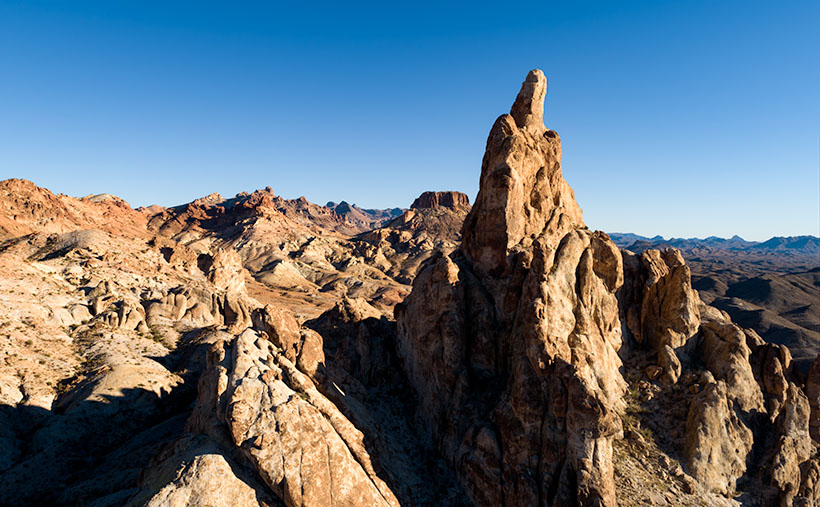
Thumb Butte – An 800′ tall granite monolith overlooking the Colorado River above Bullhead City.
As you descend into the river valley, a thing that jumps out at you is an 800′ tall granite monolith on the left side of the road. It’s called Thumb Butte on the maps, but many locals call it Finger Rock. It’s visible in both towns—Bullhead City and Laughlin—and from there, it looks like the universal gesture of ill will, the big bird, the highway salute, or whatever your favorite euphemism for the middle finger is. (There is another landmark a couple of miles south officially named Finger Butte—don’t confuse the two.)
I have wanted to photograph the rock before, but my schedule prevented me from stopping. On this year’s trip, I decided to make time. I watched videos, poured over the Topo maps, and found a Jeep Trail that goes right by the tower. So, late afternoon, Archie and I drove the dirt trail and took this week’s photo, which I call Thumb Butte.
I wanted to capture some depth and texture, so I shot the rock from the north side, looking into the Mount Nutt Wilderness Area. I’m happy with how this image captures the rugged terrain of the Black Mountains—if only a tiny sample. Maybe I should regularly go back and work the entire range—from Needles to Hoover Dam. What do you think?
You can see a larger version of Thumb Butte on its Web Page by clicking here. Please return next week when I will show another photo from Union Pass and SR 68.
Queen Anne, my darling wife, flew east last month to join her sisters for a week in New England. Supposedly it was an Autumn-Leaves tour, but they went to Salem in October during a full moon. I’m no math whiz, but I know what you get when you put four and ten together. That’s right—witches!
I’m a big boy, so I wasn’t about to spend my time alone sulking and drowning my sorrows in a tub of Cherry Garcia—I intended to treat myself to a night on the town—another town—in another state. Laughlin, Nevada is an easy three-hour drive from here via Kingman, across Golden Valley, through the Black Mountains, and down to the river. I booked a cheap casino hotel room for Wednesday night and set off determined to lose some money on a craps table.
The downside of weekdays in Laughlin is that it’s mostly closed. The big weekend crowds are working, so the remaining patrons are retirees like me. Half of the restaurants are dark, and some of the casinos don’t open the gambling tables. You have to search for a place to eat and find some action, so that’s how I ended up at the Riverside Casino. They had a couple of working Blackjack tables and one craps table. I think the staff outnumbered the players when I joined. Two people were on the right of the stickman, so I claimed an open spot on the left.
Trying to get a feel for the player’s moods, I looked at the faces around the table. Because masks were mandatory, it was hard to tell who was doing well. A woman across from me wasn’t even a whole face at all—only a pair of brown eyes behind jewel-rimed glasses and silver-blue hairdo peering over the table’s edge. Just like my mom, her short hair had enough hairspray to keep it in place between weekly salon visits. She had a few chips on the rail pushed to one side so they wouldn’t block her view of the playing field.
I placed my bet; someone threw the dice a couple of times and lost. Then we all took a turn bouncing the dice off of the far wall when the silver-haired lady stood up. Until then, I didn’t realize she was sitting. Even when she stood, she wasn’t much taller. She scooped up her remaining chips into a clutch. I thought she was leaving. Instead, she began pushing a walker towards my side of the stickman.
As she maneuvered her tricked-out lavender walker behind the dealer, I saw that she had dressed to party. She had on a very sparkly silver lame top and black spandex pants—which, quite frankly, bagged a bit. Weirdly, as I watched her, I suddenly heard Lenard Cohen singing his tune—Closing Time—in my head:
“…And the place is dead as Heaven on a Saturday night And my very close companion Gets me fumbling gets me laughing She’s a hundred but she’s wearing Something tight…”
When she got close, she spoke through her mask in a voice that comes from years of smoking Chesterfields, “Hey, big boy. You need a good luck charm.”
“Hi,” I smiled (a useless gesture behind my mask) and introduced myself, “I’m Jim.”
“Nat-ly,” she replied.
“It’s a pleasure to meet you, Natalie.”
“No. I’m from Flatbush. It’s Nat-ly,” she corrected with furrowed eyebrows.
“Sorry. What kind of good luck charm are you talking about?”
She explained, “Well, every high roller knows it’s good luck to have an attractive woman beside him while he rolls the dice. You’re alone, and I’m the best-looking dame in the joint.”
Just a glance around the room was enough to confirm to me that she was right. “What’s in it for you?”
“Well, you tip me each time I blow good luck on your dice.”
I was curious, “Do you do this for everyone?”
“Na,” she blushed and went on, “The girls and me spotted you the minute you came through the door.”
“That was because of my dashing good looks and natty fashion sense, I bet.”
“No. You’re the only man in the casino standing upright without a cane. You know how cougars are; we like ’em young and stupid.”
With that, Nat-ly positioned her seat to my right and plopped herself down. On my roll, she blew on my dice for luck. I even made my point once, so her luck wasn’t all bad. “You’d do even better if I hung off your shoulder,” she offered, “It’s only $20 bucks.”
I couldn’t imagine how she could reach that high given her stature, so my curiosity bettered me. I handed her a couple of chips. She reached down and pulled a cane from the tool rack attached to the walker’s side. Then she raised it and hung the crook over my shoulder and began gently stroking it back and forth. I almost burst out laughing, but she was so adept that it felt alright.
The next thing she said was, “For $5 more, I’ll play with your ear.” When I turned, she was holding one of those trash-grabbers for me to examine. I declined, so she slipped it back into its rack spot.
The night passed, the dice went clockwise around the table twice while we talked. She worked at the Mustang Ranch until the Feds seized it, and she retired. Since the Treasury Department was managing the business, she got a federal employee pension. After she quit, she moved south from Reno for a warmer climate and affordable housing. Now, she spends her free time watching the tanned muscle boys ride jet skis up and down the river.
I managed to hold onto my bankroll an hour and a half before it ran out. As I packed my things, I looked down and saw Nat-ly slumped over—asleep. I knew that the dealers wouldn’t let her stay at the table alone, and I didn’t want to wake her. So, I pushed her to the nearest quarter slot machine and parked her in front of it. I reached into my pocket and threw all but one of my quarters into the tray. The last, I stuck in the coin slot. I knew that security wouldn’t bother her as long as there was a bet on the table. With that, I left and went to my room. Tomorrow I have pictures to shoot, so the day will begin early.
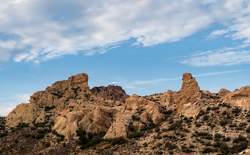
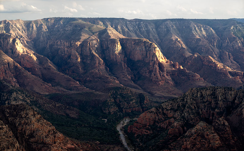
Union Pass – To cross from Kingman to the river, you drive through Union Pass. Here we see layers of Tuff – volcanic ash – broken and tossed in the air when the Black Mountains formed.
The last time I crossed through Mohave County’s Black Mountain Range was last year on our Oatman trip. I always find something new every time I travel through, which was the same on this excursion. As I drove through Union Pass, I made a mental note that I should get up early and shoot while the light was good. When the morning alarm went off, I got dressed in the dark, packed the truck, and headed to Denney’s for coffee and breakfast. I was determined to stop on the hilltop and photograph the beautiful rugged terrain. on the drive home
This week’s featured image is a part of my morning’s work. I call this photo Union Pass because that’s where I pulled to the roadside and walked up and down the highway shooting as quickly as I could. A thin gauze of clouds filtered the morning light, which is why the shadows are soft in this shot. That’s good because it shows the rock’s layer details. I believe they’re the Tuff that we learned about from Organ Pipe N.M. Tuff is volcanic ash that covers the ground in layers. Here we can see those layers have been broken and thrust into the air when the Black Mountains formed.
You can see a larger version of Union Pass on its Web Page by clicking here. When you come back next week, I’ll show another picture of my time hanging out in Union Pass.
Trick or Treat
smell my feet
give us something good to eat Since this is my first-ever Halloween post, I couldn’t pass that up.
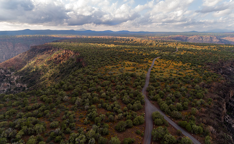
So, where were we? Oh yes—Queen Anne and I spent an afternoon exploring and photographing along the back roads to Sycamore Point. The sun was going down, and we wanted to get back to Williams to have a nice dinner at The Red Raven Restaurant. Before we leave, let me get in one more shot.
Sycamore Point – From Sycamore Point, looking back over Thumb Flat to Bill Williams Mountain.
I call this week’s photo Sycamore Point. If it isn’t apparent, I took it with my drone. Unlike a normal camera, you can’t spontaneously whip it out and start flying about—well, not if you want to keep your license. You have to file a flight plan, conduct a pre-flight check, and there are no fly areas. In this case, I couldn’t fly it past the wilderness boundary (you can get an exception from the BLM—but that takes weeks).
The truth is that I took several drone shots of the canyon, but because the drone’s camera lens is ultra wide, the images from my Sony were better, so I used those. Since the drone had battery time left, I turned it around and pointed the camera toward the road we traveled. From an altitude of two-hundred feet, this is the image that I got.
When I started processing this photo, I realized that it has everything that we’ve been talking about during October. In one image I see Alligator Juniper, patches of yellow wildflowers, Thumb Flat, the edges of Sycamore Canyon, burn scars, the back road, shafts of sunlight, and in the distance, the Northern Arizona Volcanic Field—including Bill Williams Mountain (center left) and The San Francisco Peaks (far right). It’s like you’re back in school, and here’s the chapter review before the test—but from a different perspective.
You can see a larger version of Sycamore Point on its Web Page by clicking here. Next week, it’s time for a new project from a different location. You’ll want to come back and see what trouble I got myself into this time.
Calendars
This year is hurtling to an end already, so it’s time for me to make new calendars. In spite of the extra cost last year we got a nice response. Inflation has taken a toll again this year. After reviewing my printer’s price list and post office shipping costs, I need to charge $20.00 for them. I know that cost is prohibitive to most of you, but they’re a limited item. I need to get one for myself and if you’re interested, I’ll print a copy for you.
The pictures for the 2022 edition are from this year’s outings. The size remains the same—6 ½ inches high (each half—about the size of a sheet of paper folded in half) and 8 ½ inches wide, and they have holidays noted on the dates. They’re printed on card stock—which is part of the expense.
In order to get them to you for Christmas (and we’re cutting it close according to the Post Office), I need to know by November 10th. If you’d like one, you can leave a comment in this post, use the contact form on my website (https://www.jimwitkowski.com/junk/index.php), or email me directly. Don’t forget to leave your contact information if I don’t already have it.
As you would expect, the edge of the Colorado Plateau isn’t smooth and polished. It’s quite the opposite. Over eons, the streams that drain the plateau have eaten away the walls and carved a series of steep canyons. These parallel canyons look like an evil witch with rheumatoid arthritis pressed her fingers into a curb of wet cement.
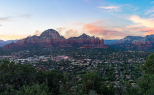
Capitol Butte and Sedona – a place of natural beauty overrun with adoring fans.
Oak Creek Canyon—and the village of Sedona—is probably the most famous example that I can name. The creek has cut into the iron-rich sandstone leaving behind beautiful red-rock formations that attract visitors from the four corners of the globe. And why not? There’s a lot to see and do here. Magazines have called Slide Rock one of the ten best swimming holes in the country (Havasupai Falls also made that list, not bad for a desert state, eh). Sedona always makes the top of the list for romantic getaways for Valentine’s Day, Thanksgiving, Christmas, and on and on and on. If you want to be romantic in Sedona these days, you have to be careful not to bump the couple making out next to you.
When people visit Oak Creek Canyon and Sedona, they understandably fall in love and don’t want to leave. Over the past 50 years, I’ve seen Sedona grow from a gas station intersection to a resort town that’s on a par with Aspen, Telluride, or Santa Fe. The catch is that there’s not enough water to support all of the rich people building second homes there. We all visit to see nature at its best, but now the McMansions are in the way. We love it to death.
But there’s hope for us tree-huggers. Less than 17 miles northwest of downtown Sedona is Oak Creek Canyon’s sister—Sycamore Canyon. Here there are no McMansions, Gucci Stores, or Whole Foods because, in 1972, the Feds set it aside as a Wilderness Area. While standing on the rim at Sycamore Point, you can begin to imagine what Oak Creek Canyon was like before the mobs got there. Imagine a time when a campfire was the only tell of humans in the area.
Sycamore Canyon – Oak Creek Canyon’s twin sister, was set aside in 1972 as a Wilderness Area to remember what nature looks like without people.
My friend Deb and I camped here before Queen Anne ever arrived on the scene. When she finally did, this was the first place Deb and I took her camping. As we ate a dinner of grilled stuffed pork chops and watched the sun go down, she was hooked. That’s when we convinced her that everything tastes a little better with dirt on it.
I wanted to come back this year after watching the fire news early this summer. One fire had ripped through here, and I wanted to see how much damage it caused. Queen Anne and I found black scars on the ridge on the canyon’s far side, but only a couple of pinions had burned on the edge where we stood. Overall, the canyon fared well, except years of drought have left Sycamore Creek dry. We didn’t see any remaining pools of water from our vantage point.
The BLM has moved camping back a half mile now. They’ve removed all of the rock fire rings and built a parking area. If you want to come here, your best camp is at one of the small lakes up the road. Since Sycamore Point is less than twenty miles from Williams, it’s an easy drive from town and back in one afternoon.
As the sun got low, it reached a crack in the clouds and lit the cliffs while I had my camera in hand. I snapped a couple of shots, and this is the version I preferred. I named the photo Sycamore Canyon. I like how the setting sun makes the cliff faces glow, but you can still see the dry creek bed below. Along the rim in the center-left, you can make out the black scar left by this summer’s fire. That’s ok though, unlike a McMansion, it’ll heal soon.
You can see a larger version of Sycamore Canyon on its Web Page by clicking here. Next week, we return to the bright lights of Williams. Come back then and see what we found.
With a basic knowledge of native Arizona plants and observational skills, it’s easy to tell what elevation you’re at in our state. Maybe only Florida is easier because the entire state is below 350′. I’ve written before about how State 48 has all but two of the world’s climate zones; sub-tropic and tundra permafrost. So all you have to do is look at the bush you’re standing next to you for a clue.
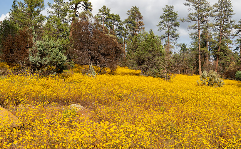
For example, compare last week’s picture to the one that I posted today. The tall ponderosa pines you see in Yellow Field thrive at altitudes over 6,500 feet. While the pinion pine in this week’s image—Thumb Flat—is the dominant plant between 5,000 and the appearance of tall pines. My rule is only a rough generalization because there are microclimate pockets all across the state. I can name two places off the top of my head as examples; Palm Canyon in the KOFA Range south of Quartzite and the east slope of the Poachie Range south of Wikiup. The state’s only native palms grow in a mountainside crevice at the first location, and the latter has saguaro and pinion pine intermingling on its slopes.
When Queen Anne and I visited Williams, it was only natural as we drove down the south slope of the dormant volcano to see ponderosa pine replaced with stands of juniper. As the White Horse Lake Road descended even lower, the juniper became sparser. By the time we reached Thumb Flat—as it’s called on the map—individual trees had stood alone in the wildflower-covered fields.
Thumb Flat – A beautiful alligator juniper stands in a wildflower-covered field.
Here I spotted this beautiful alligator juniper, which made me stop Archie and get its portrait. I think this specimen would be a prized possession in anyone’s garden. Probably the only reason this tree isn’t already in somebody’s front yard is that it’s in the middle of the Kaibab National Forest.
In this week’s featured image that I call Thumb Flat, I like how the foreground is darker in color from being in the shade of a cloud. It contrasts nicely against the bright white background cumulus clouds. The wildflowers are the same as in last week’s image, but you can see how much more dull they are when they’re not in direct sunlight. In this case that’s OK because they’re not the subject here—this week, they’re only playing a ‘walk-on’ part.
You can see a larger version of Thumb Flat on its Web Page by clicking here. Next week, we turn onto another side road, so come back and see where that road ends.
Until next time — jw
P.S. If the picture is not showing up in your email version of this post, you can click on the article title (Thumb Flat) to open the Web version of this post.
The four roads out of Williams, Arizona, point to the four compass directions. To the east and west is Interstate 40—the modern-day version of Route 66 and even older trails that the First Nation People used. To the north is Arizona Route 64—the busiest route to the Grand Canyon. The least traveled road goes south and is Coconino County Route 73, or Perkinsville Road. This is the back road that we’re using for this month’s project.
If you’ve never heard of the town of Perkinsville, it’s understandable. It’s been a ghost town ever since its lime quarry shut down in the 1950s. Several families still live in the Perkinsville area, but its biggest claim to fame is the Verde Canyon Railroad stop, where they turn the train around. Also, if you’ve ever bought Arizona red flagstone, it comes from neighboring quarries between Drake and here.
To get to our road, you take 4th Street south from downtown Williams, to where it changes name at the town’s edge. The paved two-lane road winds through Cataract Canyon past a handsome masonry dam and reservoir. The railroad built it to supply water for the steam trains, and the name, Santa Fe Reservoir, has stuck. Shortly after, the road climbs up and over the east shoulder of Bill Williams Mountain, and you’re quickly in a ponderosa pine forest.
Within minutes you reach the road’s crest, and open pastures appear. Here you’ll see hiking trail signs that direct you to a trail that climbs to the mountain’s 9253-foot summit—should that be something on your bucket list. Further along, there’s another side road that goes to the Williams Ski Area. I didn’t even know that Williams had a ski area.
As Anne and I drove along the downhill slope, juniper replaced the tall pines, and large fields of yellow wildflowers were all around us. The good rains that we’ve had this summer have been beneficial for the flowers. We continued south on CR 73 until we turned east onto White Horse Lake Road. We were out after a weekend of rain, and although its surface is packed gravel, it’s navigable even for a 2wd sedan.
Yellow Field – The abundant monsoon rains that we’ve had have been perfect for the wildflowers.
Since the flowers were so profuse, I wanted to take their picture with the sunlight beaming down on them, but a cumulus cloud got in the way every time I stopped Archie. I played this cat-and-mouse game several times before I captured this week’s featured image. I call it Yellow Field. I don’t know the flower’s actual name, but it’s the same weed we’ve been spraying for the past month in our yard. Wildflowers is weeds—who’d have thunk?
You can see a larger version of Yellow Field on its Web Page by clicking here. Next week, we’ll show more of the scenery we found on White Horse Lake Road. Come back then.
Most of our photo outings are day trips, but when we go too far away, we spend the night with the Patels. That means eating on the road. Usually, dinner out, and If the motel doesn’t provide waffles, then breakfast too. That was the case on our recent Williams trip.
My default reference is Trip Advisor to find a decent place to eat. I’ve even contributed a couple of reviews. When I looked up a place for dinner in Williams, their top-rated restaurant was the Red Raven. With a bit of effort and a couple of mouse clicks, I pulled up their dinner menu on my screen. Right off the top, I found two dishes that I enjoy listed under house specialties; Filet Oscar and Grilled Duck Breast (I’d order duck more often, but when I do, Anne—in her best Daffy Duck voice—says, “Thatssh Dishspickable.”). With items like that on the menu, we had dinner sorted before we jumped into Archie.
Ambiance
The first unusual thing was at Red Raven’s front door. It was locked with a note above a doorbell that read, “Please Ring for Service.” After you ring—sometimes twice—a hostess greets you outside. I don’t know if this is their standard modus operandi or a Covid 19 thing, but it works well. After your greeter politely asks a couple of questions—party number, reservations—they find a table and usher you inside. Right away, you see that although the ceiling is above the two-story arched windows, it’s a small room with a limited number of tables. Managing the door this way reduces unnecessary tourist traffic—like people wanting to use the bathroom.
The dining room takes up the entire width of the brick building, and the tables are spaced apart in three rows. The wall bottoms are wainscoted with a pleasant green beadboard. The plastered walls above the chair-rail are painted a soft yellow—buttercup or custard if you’re into that sort of thing. High and well out of reach is a plate rail with china and other trinkets tastefully displayed. The hanging artwork resembles a Pairs bistro. Missing from the décor are novelty signs with folksy sayings, and there isn’t a single TV anywhere. Once you’re seated at your table, you’ll notice that the staff is all women. The waitresses wear classic French bistro aprons, and the hostess is the manager doing double duty.
Menu
The menu provides several choices for appetizers, salads, specialties, grilled entrees, and plates of pasta. Their wine list is impressive for a small place. It includes several choices for each grape varietal, so it covers several pages. They have a good selection of beer on tap, including some from the local Williams craft brewery.
I was first attracted to the Filet Oscar. Traditionally it’s a veal dish topped with crab meat, asparagus, and béarnaise sauce. Veal has become persona-non-grata these days, so the chef substituted beef filet in its place. It’s been years since I’ve had any version of Oscar, but then I saw the price. Knowing that we needed gas money to get home, I ordered a New York strip with a side of béarnaise instead. I like to compare with my own. From the list of sides, I chose a couple of things I’ve never had; Southwest Pilaf and Tempura battered Broccolini. Anne also went with a New York strip but smothered hers with mushrooms in a Worcestershire and white wine sauce accompanied with mashed potatoes and vegetables.
Our Meals
Anne started with a house salad and vinaigrette dressing. It looked green and fresh. I had the daily soup, which they called Hot Italian Sausage and Vegetable puree. I’m familiar with the Italian Wedding version with a clear broth, but this looked like a lumpy split pea. It didn’t taste like that. The sausage was spicy, and the creamy puree was delicious. I soon annoyed the rest of the guests with my slurping and spoon, trying to scrape every drop out of the bowl.
Next, the mains came out looking appetizing on the plate. Our 8oz steaks were cut in European style—sliced thin with all of the fat trimmed off—more like a cutlet than a chop. I prefer my steaks twice as thick because thinner cuts are often overcooked. Not a problem here. The chef grilled both our steaks a perfect medium-rare. They had good flavor but sadly was a bit on the tough side. I enjoyed the sauce, which was very tangy, just like I make mine. If I had a gripe, it would be with the pilaf. Calling a dish Southwest means that it ran into a jalapeno at least once. My serving was simple pilaf. Anne said that her steak was as she ordered it, but she thought the potatoes were loose.
I usually skip dessert, but Anne insisted on a menu. The Queen picks her deserts by how many times the word chocolate appears in the description. She found one. Chocolate, on top of chocolate, wrapped in chocolate, then run over with a chocolate truck. There was enough cocoa to satiate her because she let me have a bite and took leftovers home in a box.
Conclusion
I can’t entirely agree with rating a restaurant with stars or forks. It’s an obscure concept and doesn’t translate into real-world experiences (especially if it’s an unknown review, like me), so I will do something different. There are no Michelin Star restaurants in Arizona, but we’ve been lucky enough to dine at a few in San Francisco. Nominating a place for a Michelin Star will be my high bar. At the scales other ends, I’m want to use a well-known but mediocre restaurant. I’m using Applebee’s for this review because we’ve all eaten there, and I’ll go to Applebee’s again if there’s nothing better. To me, Applebee’s is … meh!
So, I think that the Red Raven is a few notches above our standard because of its atmosphere, imaginative menus, preparation (the food is cooked in-house), taste, and service. It is not at the Michelin level (yet?), and I agree with the Trip Advisor reviewers. With some improvements, we could stop qualifying our recommendations by saying: “It’s a great restaurant—for Williams.”