Thumb Butte Picture of the Week

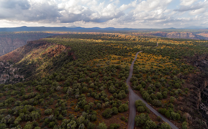
Arizona State Route 68 in Mohave County has substantially improved since I first visited Bullhead City decades ago. It was a two-lane back road with faded markings and crumbling tarmac. When it rained, it was impassable because the highway ran through the flooded wash bottoms. These days, it’s a mini-interstate with four lanes and no lights or signs along its 28-mile length. It’s impressive how infrastructure improves when it involves getting people into casinos.

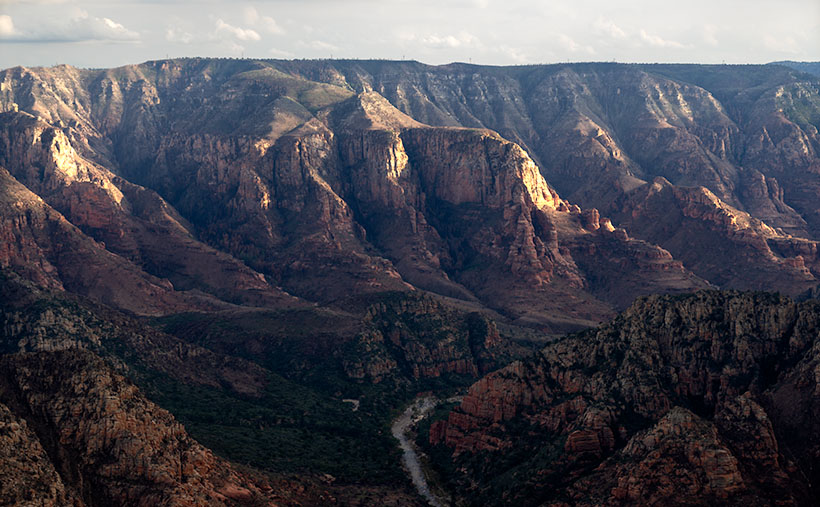
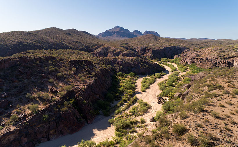
SR 68 also has one of the best views of all the roads I’ve traveled. That vista comes just west of Union Pass in the Black Mountain Range. When you see the Union Pass elevation sign (3570 feet), you can tell it’s coming. There is a wide shoulder here to enable truckers to safety-check their brakes. Immediately after you clear the mountains on either side of the highway, you can see a panoramic view of the Colorado River 3000′ below. Beyond the blue water ribbon, you can see into the Nevada Desert going on forever—especially now that APS has dismantled the coal-fired Mohave Power Station. You don’t have long to enjoy the view because suddenly you’re on the downhill side of the roller coaster, and just for giggles, the highway department put a stoplight at the bottom of the 11 miles of 7% grade.

Thumb Butte - An 800' tall granite monolith overlooking the Colorado River above Bullhead City.
Thumb Butte – An 800′ tall granite monolith overlooking the Colorado River above Bullhead City.

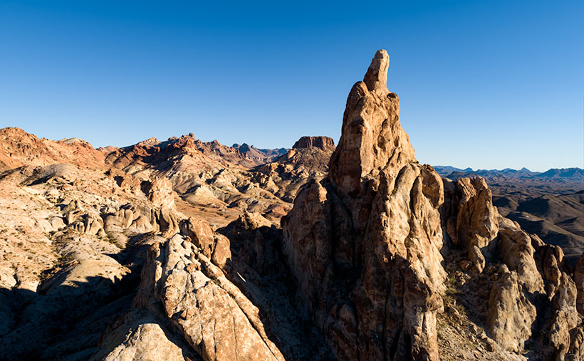
As you descend into the river valley, a thing that jumps out at you is an 800′ tall granite monolith on the left side of the road. It’s called Thumb Butte on the maps, but many locals call it Finger Rock. It’s visible in both towns—Bullhead City and Laughlin—and from there, it looks like the universal gesture of ill will, the big bird, the highway salute, or whatever your favorite euphemism for the middle finger is. (There is another landmark a couple of miles south officially named Finger Butte—don’t confuse the two.)

I have wanted to photograph the rock before, but my schedule prevented me from stopping. On this year’s trip, I decided to make time. I watched videos, poured over the Topo maps, and found a Jeep Trail that goes right by the tower. So, late afternoon, Archie and I drove the dirt trail and took this week’s photo, which I call Thumb Butte.

I wanted to capture some depth and texture, so I shot the rock from the north side, looking into the Mount Nutt Wilderness Area. I’m happy with how this image captures the rugged terrain of the Black Mountains—if only a tiny sample. Maybe I should regularly go back and work the entire range—from Needles to Hoover Dam. What do you think?

You can see a larger version of Thumb Butte on its Web Page by clicking here. Please return next week when I will show another photo from Union Pass and SR 68.

Until next time — jw

Sycamore Point – and – Calendars     Picture of the Week

Trick or Treat
smell my feet
give us something good to eat

Since this is my first-ever Halloween post, I couldn’t pass that up.

So, where were we? Oh yes—Queen Anne and I spent an afternoon exploring and photographing along the back roads to Sycamore Point. The sun was going down, and we wanted to get back to Williams to have a nice dinner at The Red Raven Restaurant.  Before we leave, let me get in one more shot.

Sycamore Point - From Sycamore Point, looking back over Thumb Flat to Bill Williams Mountain.
Sycamore Point – From Sycamore Point, looking back over Thumb Flat to Bill Williams Mountain.

I call this week’s photo Sycamore Point. If it isn’t apparent, I took it with my drone. Unlike a normal camera, you can’t spontaneously whip it out and start flying about—well, not if you want to keep your license. You have to file a flight plan, conduct a pre-flight check, and there are no fly areas. In this case, I couldn’t fly it past the wilderness boundary (you can get an exception from the BLM—but that takes weeks).

The truth is that I took several drone shots of the canyon, but because the drone’s camera lens is ultra wide, the images from my Sony were better, so I used those. Since the drone had battery time left, I turned it around and pointed the camera toward the road we traveled. From an altitude of two-hundred feet, this is the image that I got.

When I started processing this photo, I realized that it has everything that we’ve been talking about during October. In one image I see Alligator Juniper, patches of yellow wildflowers, Thumb Flat, the edges of Sycamore Canyon, burn scars, the back road, shafts of sunlight, and in the distance, the Northern Arizona Volcanic Field—including Bill Williams Mountain (center left) and The San Francisco Peaks (far right). It’s like you’re back in school, and here’s the chapter review before the test—but from a different perspective.

You can see a larger version of Sycamore Point on its Web Page by clicking here. Next week, it’s time for a new project from a different location. You’ll want to come back and see what trouble I got myself into this time.

Calendars

This year is hurtling to an end already, so it’s time for me to make new calendars. In spite of the extra cost last year we got a nice response. Inflation has taken a toll again this year. After reviewing my printer’s price list and post office shipping costs, I need to charge $20.00 for them. I know that cost is prohibitive to most of you, but they’re a limited item. I need to get one for myself and if you’re interested, I’ll print a copy for you.

The pictures for the 2022 edition are from this year’s outings. The size remains the same—6 ½ inches high (each half—about the size of a sheet of paper folded in half) and 8 ½ inches wide, and they have holidays noted on the dates. They’re printed on card stock—which is part of the expense.

In order to get them to you for Christmas (and we’re cutting it close according to the Post Office), I need to know by November 10th. If you’d like one, you can leave a comment in this post, use the contact form on my website (https://www.jimwitkowski.com/junk/index.php), or email me directly. Don’t forget to leave your contact information if I don’t already have it.

Until next time — jw

Sycamore Canyon Picture of the Week

As you would expect, the edge of the Colorado Plateau isn’t smooth and polished. It’s quite the opposite. Over eons, the streams that drain the plateau have eaten away the walls and carved a series of steep canyons. These parallel canyons look like an evil witch with rheumatoid arthritis pressed her fingers into a curb of wet cement.

Capitol Butte and Sedona - a place of natural beauty overrun with loving fans.
Capitol Butte and Sedona – a place of natural beauty overrun with adoring fans.

Oak Creek Canyon—and the village of Sedona—is probably the most famous example that I can name. The creek has cut into the iron-rich sandstone leaving behind beautiful red-rock formations that attract visitors from the four corners of the globe. And why not? There’s a lot to see and do here. Magazines have called Slide Rock one of the ten best swimming holes in the country (Havasupai Falls also made that list, not bad for a desert state, eh). Sedona always makes the top of the list for romantic getaways for Valentine’s Day, Thanksgiving, Christmas, and on and on and on. If you want to be romantic in Sedona these days, you have to be careful not to bump the couple making out next to you.

When people visit Oak Creek Canyon and Sedona, they understandably fall in love and don’t want to leave. Over the past 50 years, I’ve seen Sedona grow from a gas station intersection to a resort town that’s on a par with Aspen, Telluride, or Santa Fe. The catch is that there’s not enough water to support all of the rich people building second homes there. We all visit to see nature at its best, but now the McMansions are in the way. We love it to death.

But there’s hope for us tree-huggers. Less than 17 miles northwest of downtown Sedona is Oak Creek Canyon’s sister—Sycamore Canyon. Here there are no McMansions, Gucci Stores, or Whole Foods because, in 1972, the Feds set it aside as a Wilderness Area. While standing on the rim at Sycamore Point, you can begin to imagine what Oak Creek Canyon was like before the mobs got there. Imagine a time when a campfire was the only tell of humans in the area.

Sycamore Canyon - Oak Creek Canyon's twin sister was set aside in 1972 as a Wilderness Area so we can remember what nature looks like without people.
Sycamore Canyon – Oak Creek Canyon’s twin sister, was set aside in 1972 as a Wilderness Area to remember what nature looks like without people.

My friend Deb and I camped here before Queen Anne ever arrived on the scene. When she finally did, this was the first place Deb and I took her camping. As we ate a dinner of grilled stuffed pork chops and watched the sun go down, she was hooked. That’s when we convinced her that everything tastes a little better with dirt on it.

I wanted to come back this year after watching the fire news early this summer. One fire had ripped through here, and I wanted to see how much damage it caused. Queen Anne and I found black scars on the ridge on the canyon’s far side, but only a couple of pinions had burned on the edge where we stood. Overall, the canyon fared well, except years of drought have left Sycamore Creek dry. We didn’t see any remaining pools of water from our vantage point.

The BLM has moved camping back a half mile now. They’ve removed all of the rock fire rings and built a parking area. If you want to come here, your best camp is at one of the small lakes up the road. Since Sycamore Point is less than twenty miles from Williams, it’s an easy drive from town and back in one afternoon.

As the sun got low, it reached a crack in the clouds and lit the cliffs while I had my camera in hand. I snapped a couple of shots, and this is the version I preferred. I named the photo Sycamore Canyon. I like how the setting sun makes the cliff faces glow, but you can still see the dry creek bed below. Along the rim in the center-left, you can make out the black scar left by this summer’s fire. That’s ok though, unlike a McMansion, it’ll heal soon.

You can see a larger version of Sycamore Canyon on its Web Page by clicking here. Next week, we return to the bright lights of Williams. Come back then and see what we found.

Until next time — jw

Thumb Flat   Picture of the Week

With a basic knowledge of native Arizona plants and observational skills, it’s easy to tell what elevation you’re at in our state. Maybe only Florida is easier because the entire state is below 350′. I’ve written before about how State 48 has all but two of the world’s climate zones; sub-tropic and tundra permafrost. So all you have to do is look at the bush you’re standing next to you for a clue.

For example, compare last week’s picture to the one that I posted today. The tall ponderosa pines you see in Yellow Field thrive at altitudes over 6,500 feet. While the pinion pine in this week’s image—Thumb Flat—is the dominant plant between 5,000 and the appearance of tall pines. My rule is only a rough generalization because there are microclimate pockets all across the state. I can name two places off the top of my head as examples; Palm Canyon in the KOFA Range south of Quartzite and the east slope of the Poachie Range south of Wikiup. The state’s only native palms grow in a mountainside crevice at the first location, and the latter has saguaro and pinion pine intermingling on its slopes.

When Queen Anne and I visited Williams, it was only natural as we drove down the south slope of the dormant volcano to see ponderosa pine replaced with stands of juniper. As the White Horse Lake Road descended even lower, the juniper became sparser. By the time we reached Thumb Flat—as it’s called on the map—individual trees had stood alone in the wildflower-covered fields.

Thumb Flat - A beautiful alligator juniper stands in a wildflower covered field.
Thumb Flat – A beautiful alligator juniper stands in a wildflower-covered field.

Here I spotted this beautiful alligator juniper, which made me stop Archie and get its portrait. I think this specimen would be a prized possession in anyone’s garden. Probably the only reason this tree isn’t already in somebody’s front yard is that it’s in the middle of the Kaibab National Forest.

In this week’s featured image that I call Thumb Flat, I like how the foreground is darker in color from being in the shade of a cloud. It contrasts nicely against the bright white background cumulus clouds. The wildflowers are the same as in last week’s image, but you can see how much more dull they are when they’re not in direct sunlight. In this case that’s OK because they’re not the subject here—this week, they’re only playing a ‘walk-on’ part.

You can see a larger version of Thumb Flat on its Web Page by clicking here. Next week, we turn onto another side road, so come back and see where that road ends.

Until next time — jw

P.S. If the picture is not showing up in your email version of this post, you can click on the article title (Thumb Flat) to open the Web version of this post.

Five Cairns Picture of the Week

If you’ve ever hiked a backcountry trail, you know about cairns. They’re the road signs hikers use to stay on track. They’re simply piles of rocks high enough to be seen and reassure travelers that they’re following the right path. According to Wikipedia, cairns have been around throughout time all around the world.

I don’t know who has the time to build and maintain these stone piles, so I’ve concluded that it must be the Pixies. If you think about it, who else has the skills to precariously balance rocks on top of one another that magically survive wind and rainstorms? You never see humans stopping to build them. Yeah, it’s definitely the Pixies.

The markers confirm the obvious on some trails—like this month’s hike up the Little Granite Peak trail. The steep climb from the parking area to the first flat was like tromping through a rain gutter. Runoff and traffic have carved a trough that’s easy to follow. On the other hand, where trails traverse slick rock areas, cairns will reliably mark the easiest path. When I hiked to Coyote Gulch in Utah, there were long sections of trail where I had to stop at one of the cairns and look for the next one before I went any further. Later I found that the markers kept me from having to scramble down treacherous cliffs.

Another time that I remember cairns saving my butt was on the outing to Cedar Mesa. While Queen Anne waited in the truck, I hiked down into Cigarette Canyon to get this shot of Fallen Roof Ruin. She insisted that I leave the keys with her. After reaching the canyon bottom, I only had to trudge a mile before I spotted the ruin nesting high in the cliffs. Paying no attention to my route, I scrambled up the smooth sandstone wall with my camera and tripod.

Fallen Roof Ruin - Built high above a canyon floor, these ruins were a strenuous hike to get to, but a treacherous path down.
Fallen Roof Ruin – Built high above a canyon floor, these ruins were a strenuous hike to get to but a treacherous path down.

After getting my shot, I started my descent, but what I saw scared me. It was one of those steep hills where you could only see the first few feet before the ground plunged out of sight—like the first hill of a roller coaster. I had visions of rescuers finding my skeletal remains among the ruins because I became trapped there. Anne would surely get bored and drive off, leaving me to rot alone. But as I searched for a way down, I spotted a pile of rocks to one side, so I headed toward them. From there, I saw more cairns that made a zigzag pattern down to the bottom. Thank God I didn’t have to make Anne put down her book and get out of the truck to find me.

Five Cairns - This little cairn didn't like the way you looked at her, this little cairn didn't like the way you spoke to her, this little cairn hated the way you bumped into her, this little cairn thought you smelled, and this little cairn went "wee, wee, wee," all the way to the police station.
Five Cairns – This little cairn didn’t like the way you looked at her, this little cairn didn’t like the way you spoke to her, this little cairn hated the way you bumped into her, this little cairn thought you smelled, and this little cairn went “wee, wee, wee,” all the way to the police station.

So, imagine my smile when I reached the first intersection on the Little Granite Mountain trail and saw five miniature cairns lined up on top of a boulder the size of a small Toyota. This spot must be where the fairies had a picnic. It was off the path behind some bushes, so these weren’t actual trail markers. They were left by the little people having some mischievous fun.

You can see a larger version of Five Cairns on its Web Page by clicking here. Next week, we start a new project, so come back and see where the road leads us.

Until next time — jw

Cirrus Streak Picture of the Week

My favorite landscape photographers have different styles of working with a horizon. There’s a group that omits the sky from their images. Charles Cramer, for example, most often leaves the sky out of his pictures. Michael Kenna and Ansel Adams use the skyline as part of their image’s graphic design. On the other hand, Mitch Dobrowner’s images are mostly sky and extreme weather. (To be honest, if I ever had an opportunity to go on one of Mitch’s shoots, I’d take lots of underwear because I’d be scared.)

I can’t think of a master photographer that exclusively shoots sky. I don’t know why. Perhaps it’s the lack of context. Clouds around the world are the same. Without a ground-based reference point, you can’t tell where or when I took the photo, and there’s no sense of scale because clouds come in all sizes.

Cirrus Streak - A wispy streak of cirrus clouds thousands of feet above monsoon cumulus clouds forming above the mountain tops.
Cirrus Streak – A wispy streak of cirrus clouds thousands of feet above monsoon cumulus clouds forming above the mountain tops.

My picture of the week, for example, could have been taken in Tibet, at the Grand Canyon, or even in your backyard. It’s not obvious what year, season, or time of day it was taken. It’s essentially a monochrome image that would work as well if it were black and white; only the subtle color in the cumulus clouds hint of the hour.

The story of this week’s image—that I call Cirrus Streak—is that this is another of my August Monsoon Clouds project. In my quest to hunt down and capture images for the project, I drove a back road through the valley between the Weaver and Date Creek mountain ranges. As I said last week, the Weaver’s (along with the Bradshaw Mountains) are a breeding ground for our evening storms.

As I drove, I noticed this streaky cirrus cloud thousands of feet above a cluster of cumulus clouds building low over the mountains. I’m partial to how the high wispy clouds get distorted into interesting shapes from the winds aloft. So, I stopped the truck and framed these clouds as a graphic design. If you’re disoriented, the blue sky gives you a clue. The color always gets lighter towards the horizon, so the mountains appear under the frame’s bottom.

You can see a larger version of Cirrus Streak on its Web Page by clicking here. Be sure to come back next week to see another image from my cloud hunt grab bag.

Until next time — jw

Date Creek and Tres Alamos Picture of the Week

Working during the summer is challenging, whether in house chores or photography. That’s why my favorite pastime during these months is procrastination. Face it; I’m allergic to heat. Thinking about going outside is worse than actually doing so. After all, in today’s southwest, we’ve learned to minimize our heat exposure. We move about in a succession of air-conditioned cocoons.

Heat is why I had difficulty coming up with a theme for  July. The monsoons haven’t kicked in yet, so most pleasant campsites are on fire or closed. I must stay close to home, venturing early or after dinner, find a shot, and then hurry home.

I decided that July’s theme will be U.S. Highway 93. That’s the main thoroughfare near my house that Phoenicians (and Tucsonans) use to commute to Las Vegas. The route goes to Canada, but I’m only concerned about day trips. Because I’ve often traveled the section between here and Kingman, I know a few vistas I wanted to capture on film but never had time to stop. This week’s image is an example.

Date Creek and Tres Alamos - Date Creek as it flows by the Tres Alamos Wilderness Area near Congress, Arizona.
Date Creek and Tres Alamos – Date Creek flows by the Tres Alamos Wilderness Area near Congress, Arizona.

North of the SR 71 – 93 junction, the Alamo-Congress Rod is a lousy shortcut to Alamo Lake. It’s a broad dirt road that gets graded annually at best. It passes the Tres Alamos Wilderness Area about 10 miles west of the paved highway. It’s a small nature preserve (83,000 acres) compared to the neighboring Arrastra Mountain Wilderness (129,800 acres). The high point on which Tres Alamos is centered is the 4257-foot Sawyer Peak. To reach the spot where I took this shot, I had to slowly travel a couple of miles on a Jeep trail that left Archie with some Arizona Pinstripes—a badge of honor for a Luxo-SUV.

The wash in this shot is Date Creek, which should be familiar to regular readers because Congress—and the old Congress Gold Mine—are located next to the mountains of the same name. As it were, the creek flows from the Weavers, along the north side of the Date Creeks, to where it merges with the Santa Maria River upstream from Alamo Lake.

An interesting thing in the photo is the tire tracks in the sand. With the rising popularity of those all-terrain buggies, it’s easier for off-roaders to drive through the washes. Most of the time, the ride is smoother than the so-called mine roads. However, in the past, you could see tracks of the animals crossing the river bottoms. It was a visitor guest book. Now that natural history is erased each time they drive over it.

When I first moved to Congress, I coveted owning an ATV. I thought it would help me get into the backcountry and get some unique landscapes. After a couple of rides in Fred’s, I found them uncomfortable because you’re exposed to the elements, and riding in his air-conditioned FJ is more my style of roughing it. Earlier this year, I got hooked on watching Matt’s Off-Road Recovery. He’s a towing company in Hurricane, Utah, and he documents his crew on YouTube as they drag 4-wheelers back to civilization. The best part is that he uses a modified Corvair Lakewood—the station wagon version. Watching him drag ATVs off mountains and dunes convinced me I was better off without one.

Click here to see a larger version of Date Creek and Tres Alamos on its Web Page. Next week, we’ll travel further down the highway and see what’s around the next bend.

Until next time — jw