Box Canyon Picture of the Week

A pair of Pueblo ruins adorn the cliff tops on either side of Box Canyon in Wupatki National Monument.

It’s November already. Time passes so fast that the remaining hair on my head flutters behind me like a streamer in the wind. To make things worse, the landlord turned off the heat. Here in the foothills, we had a couple of mornings in the high 30s, and Queen Anne insisted on sleeping with the bedroom window open. When I got up, I was invisible, standing in front of the blue accent wall—nothing but a pair of whitey tighties and chattering teeth floating through space. This cold front is supposed to move out later this week, so I’ve resisted turning on the heater. Instead, we throw back the curtains, put on heavier sweaters, and shiver till noon.

With the new month, we started a new project and didn’t have to travel far to get to it. It’s the housing development across the street. The street is Highway U.S. 89, and the development is Wupatki National Monument. Wupatki shares the access road and visitor’s center with Sunset Crater National Monument—they’re conjoined twins. During this year’s fire season, the fires closed the 35-mile park road at the crater, but Wupatki remained open because it’s north and out of danger.

Wupatki is at the base of one of the Navajo’s four sacred mountains: Flagstaff’s San Francisco Peaks, Mount Taylor in New Mexico, Hesperus Mountain near Durango, and Blanca Peak outside of Alamosa. The Dine’ considers the area with these mountains their home. But, long before the tribe moved from central Canada, Pueblo Indians lived here. They left behind stone homes along the Colorado Plateau: from Wupatki to Chaco Canyon and Mesa Verde south to Walnut Canyon.

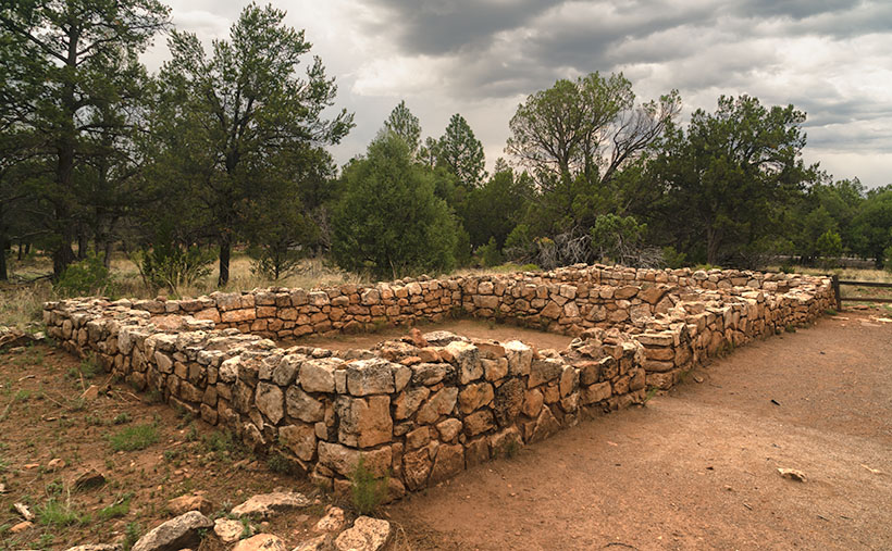
Most Americans consider Mesa Verde National Park the most extensive collection of pueblo ruins, but Wupatki is its match. In some areas, our National Monument exceeds the Colorado Park in the number of dwellings per square mile. When you visit the monument, the maps direct you to displays unearthed and restored by archeologists that you can walk through and hear thousand-year-old ghosts. As you drive to these exhibits, keep your eyes peeled because you’ll see piles of rocks in the fields and on hilltops. These are not natural clumps of stones but more ruins that the scientists haven’t yet examined. These areas are set aside for future paleontologists to examine using more advanced tools.

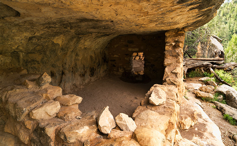
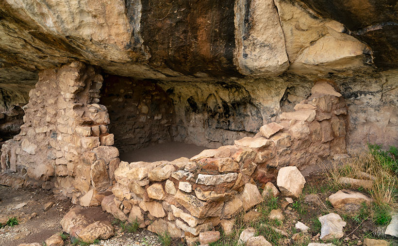
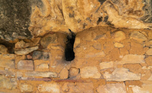
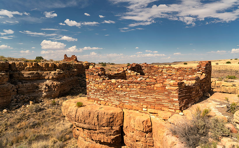
There are so many ruins in Wupatki to enjoy I can’t cover them all in one month. For November, we’re only covering a half-mile hike called Box Canyon. In that short distance, you pass three ruins along the way to the main exhibit—Lomaki. This week’s picture is of a pair of stone buildings standing on the cliffs of Box Canyon. As I walked along the paved trail on a warm summer afternoon, I stopped at each ruin, photographing what I saw. The path led up a gentle slope from the parking area, past the first ruin. From there, I could see the second dwelling on the other side of the canyon, so I continued along the trail. I could have spent the rest of my time shooting these two, but when I reached this spot, I could see Lomaki, which is more prominent with even more rooms. I quickly framed this scene and moved on to the big show.

I chose this image to start this month’s project because it shows the proximity of the two ruins along the canyon walls and how they rise above the grasslands. I assume different families occupied them. There’s enough space for privacy, but they’re close enough to provide mutual protection and borrow the neighbor’s lawn mower.

You can see a larger version of Box Canyon on its Webpage by clicking here. Next week, we’ll walk up to Lomaki and spend some time there. Come back then for another episode of This Old House. I’ll leave the light on for you.

Till next time
Jw

BTW:

Don’t forget to get your calendar order in before the cut-off on the 15th.

Secret Passage Picture of the Month

Secret Passage - The only door between units that I noticed was this one.
Secret Passage – The only door between units that I noticed was this one.

I’m going to shake the box and change the format of this week’s post because I want your advice on something. This is the last photo from Walnut Canyon, and I’m sure you’re tired of my bellyaching about stairs, so I’ll start with the background of this week’s picture, and then we can go into the conference room for the other thing.

This week’s picture shows a doorway between dwellings at Walnut Canyon. Since it’s hidden in plain sight, you probably wonder, “What’s the secret?” Well, as I hiked past ruin after ruin, this was the only inter-unit doorway I noticed. We may never know the secret— why weren’t there more of them.? Sinagua built their dwellings with shared walls, like our present apartments. I wonder if neighbors were extended family or strangers. The door suggests that family shared these homes—but it could also mean that the Sinagua Rockefellers lived here, and this unit was their equivalent of a south-facing Manhattan penthouse overlooking Central Park. As usual, there’s a larger version on its Webpage that you can get to by clicking here.

“Now, for something completely different” – Monty Python

I use my favorite coffee cup religiously in the mornings, and when I can’t find it, I panic. I search everywhere until I see it in the microwave. It was in there because I was heating yesterday morning’s dregs and forgot about it. I had it custom printed with one of my photos, but the picture is worn after six years of use. Reluctantly, I ordered a new one.

New Cup - On the front of my new coffee cup, I printed my photo of Dos Cabezas Mountain.
New Cup – On the front of my new coffee cup, I printed my photo of Dos Cabezas Mountain. Now that I’ve used it several times, I won’t order the black trim again. In the early morning, it’s hard to see where the coffee is with sleep in my eyes.
Coffee Cup Back - On the back, I put the title and some advertising.
Coffee Cup Back – I put the title and some advertising on the back.

When it arrived, I thought, “These could be great little contest prizes.” In the past, Queen Anne and I sponsored contests and gave away a photo as a prize. That’s how we got a name for Anne’s Mazda and our famous campfire treats. Now my brain is nagging me to work on another idea.

The second component is my annual calendar. As some of you know, I assemble pictures into my calendar and offer them for sale at cost. Because I usually print less than a dozen, their price is much higher than a Costco calendar, but I typically get a few subscribers that want one. After several years, I’ve figured out a system to make them come out as planned.

The next ingredient is these weekly posts. Over the years, my articles have evolved into a dependable format. Each month I pick a location, shoot pictures, and then publish the best photo each week. As Emeril Lagasse used to say, “I think I can kick it up a notch; Bam!

My idea is: What if I added a picture of the month (POM) to the mix, and you helped choose them? Let me explain. At the close of each monthly project, I include a survey (like the example below), and you choose the picture you most liked. Of course, I could be the Supreme Leader and pick what I want and be done with it, but over the years, I’ve learned that my taste isn’t the same as the public’s. So a poll makes it more like the People’s Choice Awards instead of the Oscars. After three days(?), we tally the survey; I’ll lay out a design and print the winner on a mug—like a trophy. Then when calendar time rolls around, I will already have a dozen winning images selected.

What’s in it for you? I already have too many coffee cups, so I’d like to give them to you. The problem is that I don’t know how to give them away equitably. Each computer (or phone) gets one recorded vote with this survey app. The polls are anonymous, with no tracking, so I don’t know who’s voting. I can’t say, “The fifth voter wins the cup.” I’ve been racking my brain trying to figure out a solution, but it pulled a synapse and passed out. I need your ideas.

Another question that I have is how limited the cups edition should be. I can’t imagine that any of you would pay $12 plus shipping for a $5.00 Walmart mug, but who knows? I am inclined to print one and be done, but I could limit it to a low number—such as five—if you prove me wrong.

I’m looking forward to reading your thoughts. Does this concept interest you? Should I grow messy white hair like Einstein’s or shave it off like Curly’s? Would you vote for a cup? What’s an excellent way to pick a winner? You can share your opinions by leaving a comment below, or if you want privacy, then use my Contact Form (the answer to the robot question is “5” if you can’t figure it out). I’ve included a poll so you can see how simple this is. Pick your favorite and click the Vote button. There’s no cup this month, but see if you can break the survey in beta testing.

Till next time
jw

Corner Unit Picture of the Week

Corner Unit - I found this unit at the end of a row of homes. It shows all four walls inside and out, so you get and idea of how large these home were.
Corner Unit – I found this unit at the end of a row of homes. It shows all four walls inside and out, so you get an idea of how large these homes were.

“283 steps” were the first words out of the park ranger’s mouth when I asked about the Island Trail. “It’s 283 steps down to the loop, and there are 67 steps around the island,” (that number could be wrong—I stopped listening after 283), “and then back up those sane 283 steps.” I thought, “It’s the cool of the morning, it’s cloudy, I’ve got water, I need pictures from the trail, so let’s do this.” Then I walked over to the top of the staircase.

Although the Island Trail is less than a mile, it’s the harder of the two in Walnut Canyon National Monument. You’d be correct to believe it went down to the creek with that name. Instead, it drops 185′ to a land bridge where you cross to an unnamed promontory that you circle counterclockwise. The trail is asphalt paved except for the sandstone steps.

The path is on a shelf where the limestone sits above white sandstone, like found in Zion National Park. The limestone erodes faster than its foundation, and like an ice-cream scooper, that erosion has gouged shallow caves into the white stone. Here is where the Sinagua built their homes. While descending the stairs, I could see dwellings on the opposite side of the creek. They’re spaced apart, so I thought that I get to shoot one or two of the rock dwellings. I was wrong. The canyon’s far side faces north—not the ideal winter location. On the island, the homes were south-facing, which helps keep them warm. As soon as I rounded the first bend, rows of rock dwellings were there for me to explore and photograph. But, I had to sit down first and rest a while—I was still shaking from coming down the stairs.

Before I got to the pictures, I had another interesting observation. I thought that since I had made it a third of the way down the canyon’s bottom, I would be able to catch a glimpse of the creek. With the heavy monsoon we’ve enjoyed this summer (yey), the foliage growing on the canyon floor was so thick it completely obscured the creek bed.

I took this week’s picture—that I call Corner Unit—at the end of several homes. Since they run into one another, they usually share a common wall—like our modern apartments. So, this one has two exterior walls, which is unusual for this neighborhood. Since the Park Service didn’t fully restore the walls, you can see the cave’s overhang and back wall. With it being open to the outside, you can get an idea of its area. The Sinagua people must have felt comfortable with this size because it’s representative of them all. If you think about it, this is a perfect size for a man cave. There’s room for a corner TV, and you can grab a brewski without getting out of the Barkalounger. Once again, however, you’d be stuck at home all day waiting for Larry to show up.

The problem with the man-cave theory is that the women built them and were primarily concerned with keeping in the warmth. In the second image, you can see where they left a vent near the ceiling. These vents allowed them to have small fires inside and let the smoke out. They were their chimneys. The families could survive the high-altitude winters by draping an animal skin or rug over the door and building a small fire.

Fire Vent and Clay Finish - The Sinagua People built vents into the walls so they could enjoy a fire and not suffocate. They also stuffed clay into the rocks to seal the rooms from drafts.
Fire Vent and Clay Finish – The Sinagua People built vents into the walls so they could enjoy a fire and not suffocate. They also stuffed clay into the rocks to seal the rooms from drafts.

The second picture also shows another innovation the women used to make winter life bearable. They hiked to a place up the creek where they could dig gold-colored clay (the color’s not essential—this isn’t The Real Housewives of Beverly Hills), then they packed it in baskets, lugged it back, and smeared it over the rock walls—inside and outside. Like caulk, the clay sealed the wall gaps and stopped drafts. The women put a lot of thought and work into their homes—the men were too lazy to take down the Christmas decorations.

After I finished my tour of the loop and got the needed photos, I was back at the foot of the stairs leading to the visitor’s center. I found out that the ranger lied. Somehow while I was out of sight exploring ruins and taking pictures, the park service snuck in and doubled the stair count. How do I know; math, simple math. I knew I would have a tough time with the climb, so I devised a system where I would climb 50 stairs at a time—then stop for water and catch my breath. Instead of five rest stops, I made 10, and I drank both of my water bottles dry. Near the top, where I could finally see the building, I made one last effort; one, two, three, four, twelve, fifteen, thirty-five, fifty. I need another rest.

I hope you enjoy seeing the ruins in Walnut Canyon. You can view the Web version of Corner Unit on its page by clicking here. Next week, I’ll have another shot from the Island Trail for you to see, but please don’t make me go down there again.

Till next time
jw

Sinagua Pueblo Picture of the Week

Sinagua Pueblo - A two room stacked-stone ruin that the Sinagua people used for ceremonial purposes.
Sinagua Pueblo – A two-room stacked-stone ruin that the Sinagua people used for ceremonial purposes.

When Queen Anne and I married, we lived most of a decade in a second-floor condo. Besides living in cramped quarters, the thing we most disdained was lugging groceries from the parking lot and up those stairs. My right knee cracked with each step. We swore then that we’d never live in a two-story house.

The Sinagua people would’ve considered us Snowflakes. Imagine your family living in a small cave with a plastered rock façade built on the side of Walnut Canyon. They scaled the canyon walls (without stairs) to get to work. Once on top, the men tended small patches of fertile soil along the edge. They grew drought-resistant crops because their name means Without Water. At least, the Spanish called them that when they first visited the canyon. For protein, they hunted deer, elk, and big horn sheep. After butchering the game, they stuffed the meat into Safeway plastic bags and lowered it on ropes.

Given my extreme age, my most significant anxiety would be getting up in the middle of the night for a glass of Water. As it is, I struggle to find our kitchen in the dark, much less climb down to the creek and back. Of course, their local wise man was in his thirties, and he knew when to stand up and declare, “Today is a good day to die.” Then as he tossed his blanket over his shoulder, he’d tromp out of the camp to the nearest mountaintop, where he’d sit for weeks until dying of starvation. Once again, I’ve proved that exercise is unsuitable for you.

There are many disadvantages to living on a cliff-side cubby hole, but for me, it’s the TV reception. It’s lousy down there. You’d need to get cable or a satellite dish. Then you’d waste time waiting for the cable guy to show up.

There are two trails for you to explore when you visit Walnut Canyon National Monument. Both are under a mile long. The Island Trail is a loop that drops into the canyon, past several dwellings, and then climbs back to the rim. We’ll explore it next week. The Rim Trail stays on top of the mesa and is easier to hike. It goes past some old crop fields and a couple of ruins. I took this week’s picture on the Rim Trail.

The image that I call Sinagua Pueblo shows a two-room stone building of generous size. This structure was probably a communal building for ceremonies and grain storage, like your condo’s community center. Here is where the Sinagua unloaded their trucks after a Costco run. Surely you realize that I’m joking. Flagstaff doesn’t have a Costco. Recovered artifacts show that the Sinagua traded with the villages at Eldon Mountain, Wupatki, and Homolovi—after a short train ride to Winslow.

As you quietly stand and admire the pueblo’s stonework, you can hear Sinagua ghosts laughing, smoking peyote, and chanting with the rhythm of deerskin drums late into the night—until the neighbors come by and yell, “turn down those damn drums.” More cowbell.

I hope you enjoy seeing the pueblo at Walnut Canyon. You can view the Web version of Sinagua Pueblo on its page by clicking here. Next week, we’ll explore the Island Trail and show those photos—if I can only make it up this last flight of stairs.

Till next time
jw

Walnut Creek Bend Picture of the Week

Walnut Creek Bend - It's perplexing to understand how a normally dry creek could carve a deep gorge into the surrounding limestone.
Walnut Creek Bend – It’s perplexing how a usually dry creek could carve a deep gorge into the surrounding limestone.

We had to break from the heat last month, so we drug the trailer up to Flagstaff. We didn’t escape the humidity, though. Since it’s the height of the monsoon season, the weather in the high country was the same as at home—only 30°cooler. There’s been a lot of news earlier this summer about the Flagstaff fires, so we found an RV park on the west side of town—right where Old Route 66 merges with Interstate 40. When we got there, the seasonal rains had already quenched the burn. U.S. 89, which both fires crossed, had reopened, but Sunset Crater National Monument is still closed. It suffered extensive damage to the campgrounds and buildings (otherwise, the cinder cone and Bonita Lava Flow were unharmed).

Our trip served a couple of purposes. First, I needed topics to get this publication through the balance of the hot summer months. Second, we wanted to take Ritz (our trailer) on a shakedown cruise to see how well it and the Jeep played together. Finally, we longed to sleep under the covers with open windows in air, not contaminated with that old-person smell—we accomplished all of that. It’s hard to describe how wonderful it felt to enjoy a glass of wine outside and listen to the sound of rain on the awning. Besides, there’s no more fabulous evening entertainment than watching a newbie learn how to do their first black-tank dump (go back and watch the 2006 movie RV again).

This month’s project is one of the excursions we made to a place that neither Queen Anne nor I have ever been to—Walnut Canyon National Monument. I’m not sure why we missed it. It’s only a couple of miles south of I-40 on Flagstaff’s east side. As you drive the road south, it transitions from Ponderosa Pine to Juniper, so the elevation is lower than the town. The monument is primarily known for the Sinagua cliff dwellings—which I’ll discuss in the upcoming weeks, but it’s the creek we’re interested in today.

On the Colorado Plateau, water generally flows to the Colorado River. In Flagstaff, however, someone put our state’s tallest mountain in the way, so water has to drain around the San Francisco Peaks. A couple of miles west of town, you cross the Flag Divide, where streams flow west of the mountains. East of the divide is the Rio Flag and Walnut Creek Drainage system. Here the streams flow east of the volcanoes into the Little Colorado River. Walnut Creek drains Mormon Lake, Upper Lake Mary, and Lower Lake Mary. You can count Arizona’s natural lakes with one hand, and this little creek drains three of them. Perhaps that explains how an ordinarily dry creek could carve a deep channel into the limestone. Of course, all of that happened before our 22-year drought. Today, Mormon Lake is a broad, shallow dry lake with a mud puddle marking its deep spot, and both Mary Lakes are similarly low.

In this week’s picture, we’re standing at a spot that overlooks a horseshoe bend in the creek. I took this photo from the north side of the canyon facing south. In the distance is Mormon Mountain, some 16 miles south. The lake is located on the left flank of the mountain. When the creek is wet, water flows from right to left and empties into Rio Flag several miles downstream. Then the river turns north and flows under I-40 until it reaches the Little Colorado River, about a mile east of the Grand Falls (sometimes called Chocolate Falls).

I hope you enjoy discovering Walnut Canyon and seeing this week’s image. You can view the Web version of Walnut Creek Bend on its page by clicking here. Next week, we’ll hike one of the trails and poke around some ruins displayed in the national monument. I hope you’ll join us.

Till next time
jw

Cochise Ranch Airfield Picture of the Week

Cochise Ranch Airfield - It's common for ranchers in remote Arizona communities to build private airfields.
Cochise Ranch Airfield – It’s common for ranchers in remote Arizona communities to build private airfields.

As a kid, one of the Saturday morning cowboy shows I watched was Sky King. The pitch for the show probably went something like this: An Arizona rancher has a spread so large that he has to use an airplane to manage it. Because our rancher (let’s call him Sky King) has this fantastic resource, the local sheriff calls on him to help find lost hikers, bank robbers, missing children, and commie spies. It’s pretty unbelievable—right? But that’s how it went. Sky King was not my favorite cowboy because he didn’t have a pretty horse. After all, how could you chase bandits and shoot at them if you weren’t riding a horse?

I don’t know about chasing bank robbers, but large ranches with private airfields are common in Arizona. I didn’t realize how pervasive they were until I studied to get a drone license and learned how to read aeronautical charts. There are several private fields near where we live.

I can think of several reasons you could justify a private field if you lived in a remote place like Cochise County. Flying into town for supplies would be helpful, but you’d need a fair-sized plane to bring home packs of Costco paper towels and toilet paper. We have trouble getting those items in our Jeep. Emergency medical visits are second on my list off the top of my head. The rancher files to a hospital, or Air Evac comes out to the spread.

The Sky King Memory block fell into my recollection dispenser when we drove by this windsock and hanger on our commute between Willcox and Chiricahua National Monument. That’s why I stopped and took this shot. I call this week’s picture Cochise Ranch Airfield, and it shows a weathered water tank, orange sock, and corrugated hanger before a clear blue sky. As you look at it, you can hear the announcer’s golden voice saying, “From out of the clear blue of the western sky comes Sky King!” Now that we’re all older and more cynical, don’t you wonder why Penny—a pretty young blond pilot and accomplished air racer—lived alone out in the desert with her flashy old uncle?

You can see a larger version of Cochise Ranch Airfield on its Web Page by clicking here. Next week we’ll stop in a ghost town and look at some of its ruins, so I’m sure that you’ll want to see that.

Till Next Time
jw

Cochise Head Picture of the Week

Cochise Head - The 8087' high peak in the Chiricahua Mountains that resembles the great Apache Chief, Cochise.
Cochise Head – The 8087 high peak in the Chiricahua Mountains resembles the great Apache Chief, Cochise.

Living with my editor-in-chief has been particularly stressful. Her sisters are coming for a visit this week. She waltzed her beloved Dyson through the house while singing to the bluebirds, bunnies, and butterflies. She stressed her red vacuum so much that she broke it and had to order parts from Ireland. I don’t think she’s well—I caught her washing a window. I’ve become the red-headed step-child. I have to eat on the back porch, I can’t use either bathroom, and my office desk is the only place I can sit. When I gave her this post to check, I had to check my hand for missing fingers. Cyndi thinks that if she passes this inspection, her sisters will let her accompany them to the palace ball. She’s forgotten that she already hooked her Prince Charming thirty-four years ago. I blame it on this sudden Bridgerton obsession.

Other than that, welcome to May. This month, we will feature images I took as we drove between Willcox and the Chiricahua National Monument. The satin ribbon that ties the collection together is Cochise County Road 186. Otherwise, it’s a collection of odds and ends that didn’t fit inside the park. Over the next five Sundays, we’ll work our way from the monument and back to town. That way, there’s some logic to my presentation.

Right from the beginning, I’m going to cheat. You can’t see the peak in this week’s picture from the highway, and it’s not inside the park, but you can see it best from there. This image is of the 8087′ high Cochise Head in the Chiricahua Mountains’ northern section. For perspective, the eroded granite head is a mile wide. The name is descriptive because it resembles Cochise, the great Apache chief, with his distinctive Mayan nose and a pine tree eyelash. Like Camelback Mountain, no person is credited for the name; everybody just agreed on the resemblance. Imagine having a mountain named for you while you were alive. Arizona has 15 counties, with 12 of them having tribal names. Cochise County is the only one named after a tribe member. I think that shows how much respect our community had for Cochise (of the other two counties, our legislature named one for a mountain (Graham) and the other for a prominent mine owner (Greenly).

When I shot this week’s picture, I tried different compositions that I call Cochise Head naturally. The one that I chose is centered, which is unusual for me. The others seemed unbalanced somehow. As you move up and down the road, the eye and forehead become more or less prominent. I took this shot from my closest position—standing on a rocky ledge overlooking Bonita Creek Canyon.

Click here to see a larger version of Cochise Head on its website. Next week, we’ll make our way back to town for dinner, but there’s a place we have to stop so I can grab another photo. Come back next week and see what I found.

Till Next Time

jw