State Route 12 Project New Publication Announcement

Utah SR 12 Magazine
Utah SR 12 Magazine-84 pages of color photos and stories printed on premium paper and you can buy on its Blurb Page.

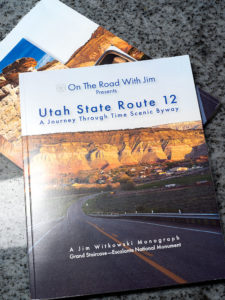
There’s exciting news this morning coming from the international headquarters of Jim Witkowski Photography, located in beautiful downtown Congress. You may have wondered why things have been quiet around here for the last six months, or that I didn’t post many photos from our Utah trip last summer. Well, I was busy using that time to compile years of photographs into my new 84-page magazine—Utah State Route 12, and I’m pleased to announce that it’s ready for début.

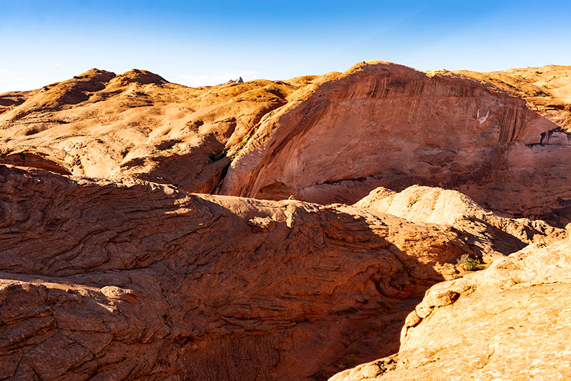
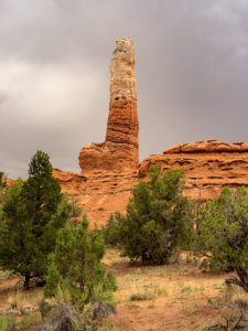
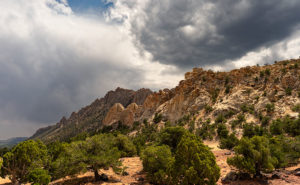
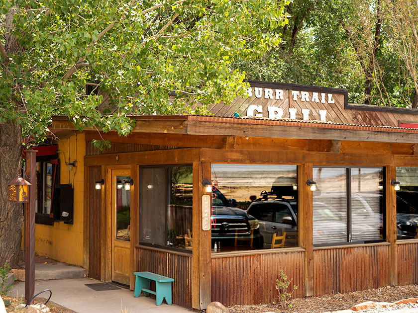
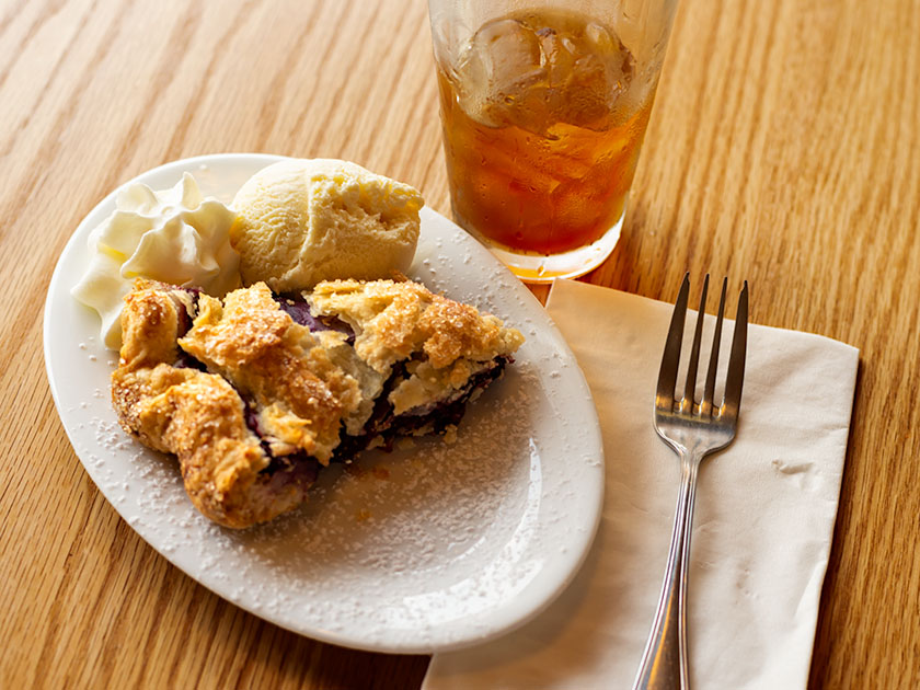
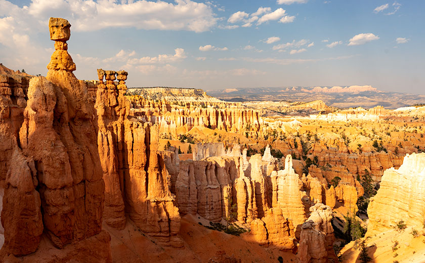
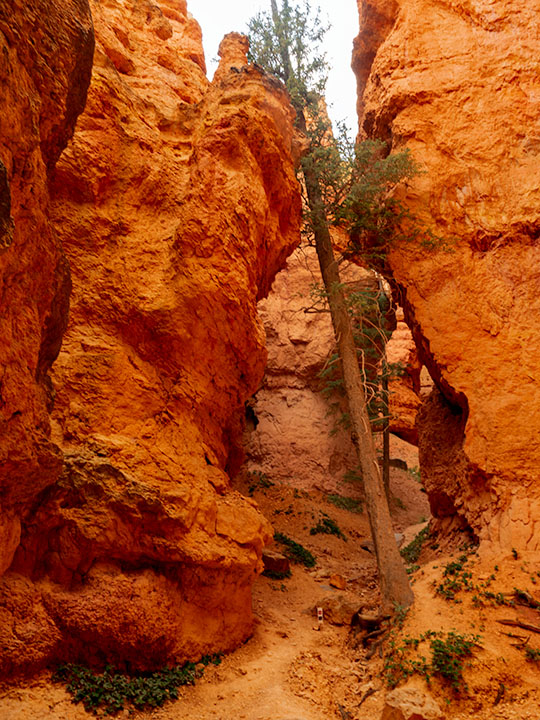
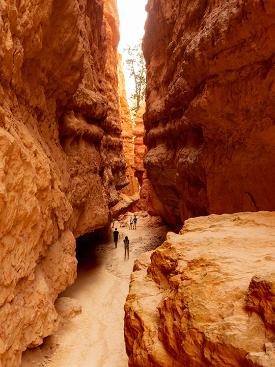
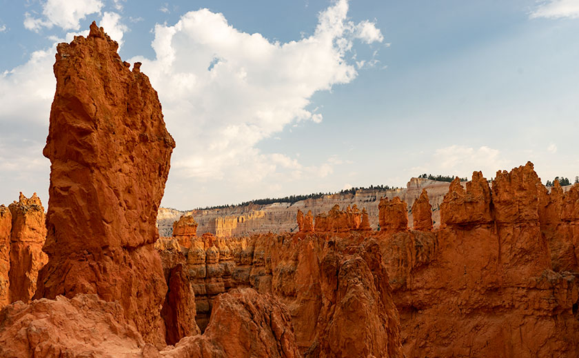
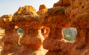
The project’s theme is about the beautiful places in the Escalante Grand Staircase National Monument. The monument is so vast that it has three management areas: the western Grand Staircase Region, Kaiparowits Region, and Escalante Canyon Region on the east flank. There is only one paved highway that spans them all—Utah’s State Route 12. In this project, I wanted to show that there are beautiful marvels to see along its length, and the road is more than just a gateway to Bryce Canyon.

I plan to release my work in four versions: PDF, Magazine, Book, and eBook. I have completed the first two, which—I believe—should get the most attention, and I’m still working on the second half. It looks like they will be ready by Valentines. (Are you in the dog house and need a gift?)

PDF—this version is best for viewing on your computer, and except for bandwidth, it’s free. It’s ideal for those of you that don’t need more clutter. You can open the file and begin browsing right away or save it to your hard drive for later.

Magazine—this is a 84-page hard copy of photos and text printed on premium stock paper. I’m delighted with how well the images reproduced. The magazine’s cost is $ 22.99 (plus shipping) is admittedly pricy for a periodical, but compared to the book, it’s a bargain. Blurb handles the sales on their secure Website because they print them to demand. That means that there won’t be surplus versions lining birdcage bottoms.

Book—the large (13 x 11) coffee table book is still in progress which sounds simple, but it’s in landscape orientation, so the layouts have to be adjusted. The photos are larger than the magazine’s, and I had more space to embellish the stories. It will be available in softcover, hardback image wrap, and hardback with dust jacket. The price of the book is expected to be under $ 200.00 at most, so I think there will only ever be one edition—my own if Her Highness lets me.

EBook—this will be the last version and will be easy to do because it’s the book reformatted to fit your Kindle. That’s all handled by the computers. I don’t know what it will cost, but it will be ready next month, so keep watching my Books sections. The downside is that with this version, you won’t get the privilege of collecting dust with it.

I’m planning on releasing a new project each year as Queen Anne, and I travel. For this first project, I had to learn the software and build the templates; something that took up development time. Future projects should go from camera to print quicker. Plans for next year’s project are in progress.

You can get your free PDF version and preview the magazine by visiting their Web Page by clicking here. I hope you enjoy viewing them and please leave your comments here and/or on their Blurb page.

Until next time — jw

Well Turned Ankle Utah Photo Shoot

The suffering that I must go through to please you people. As I sit here on the couch and looking at my right leg propped up by a pillow, I see that my ankle is thicker than my calf muscle. I had a friend in high school—a girl—who’s legs looked like this. She always lamented that they installed her legs upside-down. That’s how my right leg looks now.

I managed to injure my ankle by twisting it on the hike back from Coyote Gulch in Utah. My pain worse because I didn’t get the shot I wanted. I was this … close. I allowed four hours to trek out, get a shot, and then hike back before the sun went down. The two-mile trail alternated between fine red-powder sand and slick rock which I preferred because I made better time while I walked it. As I neared the canyon, I was concerned because I couldn’t see it. It’s the same as Horseshoe Bend on the Colorado River, so you have to walk to the edge to look into the chasm. The photo shows just how close I got and when I took it, I was not on the trail. What you can’t see in the picture is that beyond the cairn the trail descends like walking down a ball. To get back up, I would have needed to crawl on my hands and knees. Incidentally, that’s a very narrow ridge to be carrying a camera pack and tripod, so yes, I was a-scared. (BTW—here’s a link to what’s down there. It’s copyrighted so I can’t post it, but I can send you for a look.)

The Top of Hamblin Arch
The Top of Hamblin Arch-This is how close I got to my subject. You’re looking at the top of Hamblin Arch, like looking at an elephant’s trunk from its brow. The cairn on the ridge marks the real trail. Behind the cairn, you can make out the arch underside.

I twisted my ankle a third of the way back, and it’s the third time I’ve injured the same ankle. Each time I was carrying a load and my foot rolled-over 90º so that my entire weight was on that pointy ankle bone. Like the other times, I didn’t have a choice but to keep walking and the two-mile trail turned into four miles, then six. I became concerned that I wouldn’t be able to get back to the truck before dark. I began having thoughts about my demise. I wondered if I’d have to eat the dead, except I was alone. I questioned when my camera and tripod would become so much of a burden that I’d discard them along the trail. In case you’re worried, I didn’t die. I got to the truck at sunset and spent the night alone under the stars. I drove back to town the next morning and called my caring wife to tell her I had to come home early—she would need time to get rid of her boyfriends—the Chippendale Dancers.

I think that after the first injury, my ankle is susceptible to re-injury. I wear good hiking boots, and because of their high tops, they have more support. With all the walking, hiking, and biking I’ve done in the past couple of years, I thought my ankle would be stronger. If I want to get back out there and get those out-of-the-way shots, I’m going to have to do strength training exercises and tape my foot up before a hike.

Instead—I’m buying a drone. The one I’ve settled on has a four-kilometer range, and I could fly it out there and get my shots from the parking lot. I’ve pondered how to get more height in my photos anyway, and a drone is a perfect answer. A drone is a medical necessity—no less than an Iron Lung. The challenge I have is that I want a quality camera equal to my current gear. That camera is $21K, and lenses start at $10K. A drone stout enough to fly it is another $7K, and the controller is another couple of grand. Sure, fifty-thousand dollars sounds like a lot of money, but that’s the cost of an emergency room visit and a couple of nights in intensive care. I wonder if my health insurance will cover it if my doctor writes a prescription.

Until next time—jw

Kodachrome Pipe Picture of the Week

When exploring Utah’s State Route 12, you really must take time for a side trip to Utah’s Kodachrome Basin State Park—20 miles east of the Bryce Canyon entrance road. Kodachrome Road runs among the cattle pastures from Cannonville to where the pavement ends and the park entrance. There is a small entry fee which you pay at the visitor’s center. If you’re camping, the park’s sites are coveted and the restrooms have flush toilets, hot and cold water, and they’re heated in winter.

Kodachrome Pipe
Kodachrome Pipe – Sand pipes are unique to Kodachrome Basin State Park and there are over sixty of them to photograph. All you have to do is find them all.

I’ve written about Kodachrome Basin in my newsletters before because it’s a favorite destination of ours. Located on the valley floor below Bryce Canyon, the elevation is three-thousand feet lower, so in winter it doesn’t have a bitter cold you’ll find back up on the hill. But it also means that summers are warmer and the temperature can crack the century mark.

Surrounding the park are tri-colored cliffs—red, white, and gray—the same colors that make up the middle three stairs of the Escalante Grand Staircase. Unique to Kodachrome Basin is its sand pipes. It’s thought that millions of years ago, this area was like Yellowstone with geysers and hot springs and as the basin sank into a shallow sea it was covered with layers of sand. The geyser’s immense pressure forced fractures in the hardening sandstone and drilled vents. Then, as the plateau rose, rivers cut into the soft sandstone leaving the hard stone pipes behind. There are over sixty pipes in the park for you to find and photograph (hmm, sounds like a book idea). The one in this month’s featured image is on a shelf overlooking the campground like a trophy on display.

Our Kodachrome visit on this trip was by accident. Each day, afternoon thunderstorms kept us off the dirt roads we’d planned to explore. Because the park roads are paved, we changed plans and wasted some electrons photographing Kodachrome Basin in the rain. My first observation is that the colors are duller when they’re wet. My second was that the trails were muddy and the washes were running so we stayed near the roads. I’ve photographed this pipe before but wasn’t happy with the result. This time, I think I have an interesting shot for you. I call this image Kodachrome Pipe, but I may have to begin numbering them in the future. Because it was so overcast, I wasn’t aware that I was shooting directly at the sun—the bright area in the photograph’s sky. While I processed the image, I tried forcing the clouds to be darker, and when I did, the sun’s disk began to show including a rainbow ring around it. The results didn’t look natural, so I dialed it back to this version.

You can see a larger version of Kodachrome Pipe on its Web Page by clicking here. I hope you enjoy viewing this week’s post and come back next week—a new month—when we’ll start a new series from a different place.

Until next time — jw

Teasdale Cock’s Comb Picture of the Week

The geological roller coaster ride that is Utah State Route 12 ends on its east side in Torrey, Utah, and as the road descends Boulder Mountain’s north slope into town, there is a jagged uplift called the Cock’s Comb (Google Earth spelling) that you can get to via the side road to Teasdale. From Highway 12, it looks like a miter—a bishop’s hat, but when viewed from the south it’s a quarter-mile long section of crust ripped from the earth’s surface and stood on end. When I did some research for this post, I found that there’s something interesting about the Cock’s Comb besides being a big old hunk of rock. There are a road and trail—Fish Creek Cove—that lead to a very large panel of Fremont Era Rock Art. I wish I knew about that while we were shooting, but now I have a reason to go back.

Teasdale Cock's Comb
Teasdale Cock’s Comb-A quarter-mile uplift found outside of Teasdale, Utah is threatened by afternoon thunderstorms.

Of all the shots I took at the site, I selected this one to be this week’s featured image because of the layers. The thunderstorm was moving north from Boulder Mountain rapidly and the main part of the rift is in shade, but the smaller ridge is still in the sun. I also thought the clump of juniper trees in the foreground added to the sense of depth. I call this image Teasdale Cock’s Comb.

You can see a larger version of Teasdale Cock’s Comb on its Web Page by clicking here. I hope you enjoy viewing this week’s post and come back next week when we show more of the dramatic landscapes along Utah’s State Route 12.

Until next time — jw

Embarrassment Pie 2018 Utah Photo Shoot

On the road, you’re forced to try new restaurants. Some of them are good, a few are poor, but most of them are blah. Most restaurant owners don’t have an interest in food and they have little imagination. They are just trying to make a buck and so the profit and loss statement dictates the menu. I mean, my mom used to put more lunch meat on our peanut butter and jelly sandwiches when she packed our school lunches than they serve at roadside dives. That’s why, when I find a place that has great food, I like to tell you about it.

Happy Couple
Happy Couple – On the grounds of the Burr Trail Grill are a pair of gas pumps as yard-art. They’re of little use for anything else now because the largest price is 99 cents.

There are eight little communities along Utah’s State Route 12. Most of them barely have a post office much less a coffee shop. Boulder is one of those small towns. It’s wedged between the—terrifying to drive over—petrified sand dunes and Boulder Mountain. If you’re not going to see the ruins at the Anasazi State Park or to drive the Burr Trail, there’s no good reason to visit Boulder … other than they—inexplicably—have two outstanding restaurants, the Hell’s Backbone Grill and—our favorite—the Burr Trail Grill. Truthfully, we don’t know about Hell’s Backbone because we stopped at Burr Trail first and keep returning each time we pass this way.

Burr Trail Grill
Burr Trail Grill – Located at the intersection of SR 12 and Burr Trail the grill is only open during the season but the food is good.

The grill is on SR 12, right at the Burr Trail—an interesting side trip that we’ll talk about another time. It’s a small wooden shack-like building that has more seating outside than in, which is good because the parking lot is usually full at lunch. It is only open during the summer—May to October—after which, the staff return to their day jobs at the ski resorts near Salt Lake City. The menu features burgers and sandwiches which doesn’t sound exotic, but I’ve had the Thai Burger and their Ruben. Each of my choices favorably impressed me. The food at the Burr Grill is good, but we dream of their pies.

Mixed-Berry-Ginger Pie
Mixed-Berry-Ginger Pie – Warm from the oven with a scoop of home-made ice cream and fresh whipped cream is guaranteed to make you forget about decorum.

This pie will embarrass you. It has the kind of crust that explodes all over the table when you put a fork to it, just like Aunt Clara made. After your first taste, you scoop up the table-crumbs and eat them. Pies are baked fresh each day and served with home-made vanilla ice cream and fresh whipped cream. There’s a changing variety each day. Anne loved the chocolate-bourbon and she had to settle for peach on our second visit.  When you order a slice, it takes a minute because they warm it in the oven. I ordered a slice of cherry-cayenne, which sounds weird, but was tangy and not hot—like a sour cherry. On our second visit, I went for the mixed-berry-ginger and that made my taste buds explode. It was the taste of berry tartness at the beginning followed by a bright splash of ginger. As you dig in, the warm pie melts the ice cream resulting in a pool of fruit-cream on the saucer. As I devoured mine, I looked across the table and saw Anne’s eyes peering over her plate while she licked it. “What!” was all she had to say for herself—queen indeed. I told you it was embarrassing pie.

When you come to explore SR 12, be sure to plan a stop in Boulder for at least a slice of pie. You may come away embarrassed, but you’ll be better off for it—recommended.

Until next time — jw

Bryce Canyon 2018 Utah Photo Shoot

Thor's Hammer And Sunset Point
Thor’s Hammer And Sunset Point – As the Navajo Trail descends, it passes by Thor’s Hammer, Bryce Canyon’s most iconic hoodoo.

Of all the sights to see along Utah’s State Route 12, Bryce Canyon is the crown jewel. All of the other stops along the way are sideshows. The park draws people worldwide and they have to use SR 12 to get to it. I, however, am a weirdo that stops at Bryce because it’s part of the highway. Interestingly, Route 12 cuts through Bryce’s north-east corner, so you get a taste of the Bryce Canyon without leaving your car.

We’ve been to Bryce a handful of times and it’s one of our favorite national parks. With elevations exceeding 9,000 ft, it’s always cooler than home. It has alpine meadows and forests of spruce, fir, and aspen, which are a definite change from cacti. There are great views from the overlooks dotting its 38-mile road and you get an understanding of the Escalante Grand Staircase when you look down from the top. Finally, there’s wildlife—if you don’t see at least one deer while in the park, well … you’re just asleep at the wheel.

Leaning Tree
Leaning Tree – At the canyon’s bottom are amazingly tall fir trees growing between formations like they were stretching to reach the light.

Like most visitors, Anne and I stopped at the overlooks on our previous visits, but I wanted to do something different this time. While we were in the visitor’s center, I asked the ranger about the trails and she recommended the Navajo Trail to get the photographs that I was looking for. It’s a loop trail that’s less than a mile and a half long. On their chart, it was a moderate hike because of its 500 ft elevation change. I thought to myself, “Piece of cake, sign me up.”

Before tackling the Navajo, Anne and I drove to the road’s end—Rainbow Point. That’s the park’s highest elevation, and in addition to the great view, there’s a flat trail—for Bryce Canyon—that loops through a grove of bristlecone pines. After completing the loop, we concluded that the bristlecone grove at Cedar Breaks was healthier, larger, and a better experience if you like walking among these ancient trees.

Wall Street
Wall Street – The Navajo Trail passes through a section called Wall Street where you’re dwarfed by the cliffs like a ‘Lord of the Rings’ setting.

As we drove back to Sunset Point where the Navajo Trail is, Anne called our insurance agent and demanded that he increase my life insurance policy—she of so little faith. When we arrived, we couldn’t find a parking space and I questioned if anyone was still at home in Europe. All of the spaces were full and a queue of three cars waited for each potential empty spot. We decided that I should go and Anne would circle the parking lot—like you do at the airport—until she found an open parking spot. With a kiss for good luck, I grabbed my camera and backpack—with water—which burst open and emptied before I made it to the rim—and set off on my great adventure.

Let me describe the Navajo Trail. On the map, it’s a 1.3-mile loop with a 500 ft elevation change. I hiked down 500 ft on switchbacks for three-quarters of a mile. At the bottom was a log-bench that felt good to sit on. Then I walked around a column and began the trek up another set of switchbacks climbing 2,000 ft in under three miles. If I went in the other direction, the numbers would have been the same. It was one of the most exhilarating things I have done in my life. I didn’t understand Bryce Canyon until it swallowed me.

Navajo Emerging
Navajo Emerging – As the trail begins to emerge, it feels like breaking the water surface after a dive.

I made my journey in 1½ hours, but I was taking photos as I plodded along the trail. I resented the kids and a young man who ran up the hill wearing flip-flops. George Bernard Shaw was right when he observed, “Youth is wasted on the young.” I’m glad that I made the effort because I got a different perspective of Bryce Canyon in a mental sense and in my work, which I hope you enjoy viewing.

Until next time — jw

Hoodoo Windows Picture of the Week

I photographed the second featured image in our Utah series on the west rim of the Paunsaugunt Plateau north of Utah SR 12. This is the plateau where Bryce Canyon is located, but this is on the opposite side. Before entering Red Canyon, there’s a dirt road that heads north to Losee Canyon (not misspelled) and the trailhead located there. In the parking lot, with a little searching, you’ll see a sign for the Arch Trail—it’s a short loop that climbs up and around the plateau’s edge. Like most trails in Utah, the Arch Trail goes up or comes down. It’s anything but level.

The Arch Trail wanders among interesting rock formations including a couple sets of hoodoos—like the ones in this week’s photo. If you’re lucky enough to wander off the trail at the right spot, you’ll find the arch that the trail is named for. At the summit, you’ll enjoy a great view of the Panguitch Valley and the Markagunt Plateau in the west. It’s not a well-maintained trail like you find in national parks, but it’s easy to follow once you’ve found it, and rangers built several flights of stairs in the difficult spots.

Hoodoo Windows
There are places outside of the Utah Parks where you can hike among the hoodoos and arches. Arch Trail near Red Canyon is one of the easier ones.

I chose this image because hoodoos always seem distant things. In this case, the trail goes right up to them. You can touch them, pose your kids in them, walk through them, and unfortunately, you can deface them with “Kilroy was here – 2018” as some people have. In this shot named Hoodoo Windows, I tried to show a feeling of intimacy with the structures. I was lucky that the light was good when I arrived at the scene—it was dinner time and the sun was on its way down.

You can see a larger version of Hoodoo Windows on its Web Page by clicking here. I hope you enjoy viewing this week’s post and come back next week when we present another image from a different Utah site.

Until next time — jw