Shadows, Boulders, and Cracks Picture of the Week

Queen Anne and I had only ventured into the Bradshaw’s once before this month’s Senator Highway adventure. We borrowed a friend’s 4wd tow truck and wanted to see how well it performed on dirt roads. We decided to drive to Crown King for Sunday brunch. It was a horrible experience—lunch was nice, but the track was one long washboard. The truck bounced so much that it took a week for our eyes to stop vibrating. That was before Google Maps—actually, it was before computers—so we added another unnecessary 50 miles to the trip. Anne swore off dirt roads forever.

That’s too bad because the Bradshaws (named for trailblazer William D. Bradshaw) fascinated me since I moved to Phoenix. From the valley, they’re the high range to the north. When you head Flagstaff, they’re the first pine-covered mountains that you pass. The Sunset Point rest stop, which is at the range’s eastern flank, is where I feel that we’ve at last got past the city limits. Finally, during the summer monsoons, they create the storms that bring rain to the valley (as I look out my window today, I see what could be our first seasonal storm—and it’s moving south from the Bradshaws—if it gets here at all).

Whenever we’ve stopped at Sunset Point, and I had to wait for you-know-who to finish up in the bathroom, I always looked up at the mountains and mistakenly thought that they were dry and deserted. I’d think to myself, “It’s too bad there aren’t any fishing lakes up there.” On our recent trip, I found out that I was wrong because back roads lace through the range leading to former mining towns filled with summer cabins. There are even a couple of small lakes—but they’re so close to Prescott, I’d classify them as town lakes. Perhaps it’s just as well that there’s no destination up there, because if there were a big lake up there, then there’d be freeways and planned communities around it.

Shadows, Boulders, and Cracks - This is the simplest essence of what I found interesting about a pair of granite boulders south of Groom Creek, Arizona.
Shadows, Boulders, and Cracks – This is the purest essence of what I found interesting about a pair of granite boulders south of Groom Creek, Arizona.

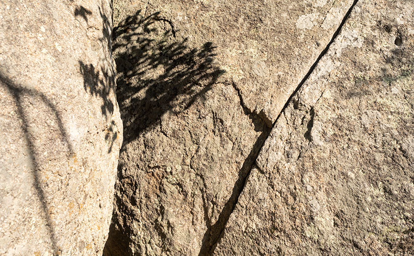
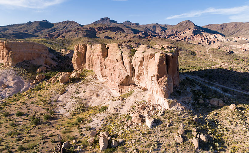
As Anne and I continued exploring Senator Highway, we came across a boulder field south of Groom Creek. I find these large lumps of granite interesting, but they’re all over the state, and my rock collection is vast. I hear people say, “Meh. It’s another rock picture.” So, for this week’s featured image, I tried to show just the part that made me raise the camera to my eye. In the case of this week’s featured image, that I call Shadows, Boulders, and Cracks, it was the texture of the massive rocks, the delicate shadows of the deciduous trees, and the fracture that splits the right sphere in half. Even without seeing the entire boulder, you instinctively know that you couldn’t skip one of these pebbles across Goldwater Lake.

You can see a larger version of Shadows, Boulders, and Cracks on its Web Page by clicking here. I hope you like it. Be sure to come back next week when we present another image from the Senator Highway going south from Prescott.

Until next time — jw

Warm Springs Cholla Picture of the Week

This morning, when I got out of bed and looked in the bathroom mirror to see if I still had a reflection, I scared myself. What little hair that I still have was standing perpendicular to my head. I think I stuck my finger in a light socket last night. I’m puzzled at how the remaining five hairs on the top of my head—which are invisible when I comb them—manage to stick straight up like a coastal lighthouse. A less intelligent Albert Einstein stared back at me. I need a haircut.

When I got out of the Army, I had thick wavy red hair, and I went to a salon every other week to get it styled. I was on the hunt for a mate back then, so I had to look my best. I patronized one of those places that charged more because they cut your hair with a razor. I paid $30 for a wash, cut and blow-dry. I spent too much time each day trying to get that Glen-Campbell-look that was popular then. Then came the 70’s, and we just let our hair grow long. When my hair curled over my ears like Bozo the Clown, it was time to go to Floyds.

I turned gray when I was in my thirties, and suddenly I was an old man. As my hairstyle paid fewer dividends, I gave up and started combing it straight back. I only got a haircut three or four times a year, whether I needed it or not. Now I visit the barber when we make a Mexican pill-run. It’s cheaper there, and—because I’m a senior—I get a discount. The tip is more than the cut, and I still get change. I don’t even care what it looks like as long as it’s shorter than when I walked in.

We’ve suspended our trips to Algodones during this pandemic, so I’m taking matters into my own hands. I ordered hair-clippers from Amazon. They were supposed to be here on Friday but didn’t arrive. I’ve worked up the nerve to let Queen Anne put it on the shortest setting and shave it all off. How bad could it be? Besides, that’s why I have hats.

The day that Queen Anne and I traveled down Old Route 66 was the exact opposite of a ‘bad hair day’ (see how I did that?). The trip produced more good images than I usually get, and with good reason. The Black Mountain Range is an exciting pile of rocks. I can see me spending more time exploring them—especially when one of you coughs-up the funds for my hover-bike.

Warm Springs Cholla - Cholla along the roadside provide a good foreground contrast for McHeffy Butte at sunset.
Warm Springs Cholla – Cholla along the roadside provides an excellent foreground contrast for McHeffy Butte at sunset.

This week’s featured image is called Warm Springs Cholla. As you can tell from the colors, I took it as the sun was setting. We were several miles south of Oatman, and I was studying a  peak—McHeffy Butte—as we drove along. Suddenly (ta-da), a patch of cholla popped up, making a perfect foreground. After I stopped the truck, I hiked a short distance uphill into the Warm Springs Wilderness and fired off a couple of shots. I think the resulting image makes a great wrap-up to our Route 66 trip.

You can see a larger version of Warm Springs Cholla on its Web Page by clicking here. I hope you enjoy it. Next week is June and another back road adventure. I hope you’ll come back and hear about our road trip.

Until next time — jw

Tom Reed Mine and Elephant’s Tooth Picture of the Week

After publishing last week’s post, I lingered in my office for a while with a nagging question. It was more of a puzzle than a burning issue, but it would persist until I solved it. My enigma was this: If Lt. Whipple completed his survey in 1854, and the railroads were already following his trail, why in 1926 did the Highway Department run Route 66 through a rugged mountain pass when they established the National Highway system? Wouldn’t it be faster and cheaper to follow the railroad tracks down to the Colorado River? I used up over half of my monthly Google query allotment trying to understand their logic. After distilling some facts that I uncovered, and with some fantasy time travel, I concluded that the department wanted travelers to go through the shining city on the hill—Oatman. When the mines were still open, Oatman was a bustling city, with a good hotel, restaurants, bars, groceries, and gas stations.

Oatman Main Street 2020 - The crowds of tourists are gone, the stores are shuttered, and even the burros are social distancing.
Oatman Main Street 2020 – The crowds of tourists are gone, the stores are shuttered, and even the donkeys are social distancing.

Arizona has two types of ghost towns, and to paraphrase a line from Frank Zappa’s song Camarillo Brillo, there are real ghost towns, and there are Walmart ghost towns. Real ones are scattered throughout Arizona’s mountains and plains. Places like Cochran, Cherry, and Ruby. If you drive there in your Jeep, you’d be lucky to find a standing building, but—most of the time—only their crumbling foundations remain. As for the latter towns, they’re thriving communities. Arizona’s big four include Jerome, Tombstone, Bisbee, and Oatman. People still live there, and more importantly, tourists visit by the busload. They come to drink in the saloons, eat lunch in the bordellos, watch the fake gunfights, ride oar carts into the mine shafts, and feed the wild donkeys. I wouldn’t be surprised to learn that these towns generate more annual revenue today than the mines ever did.

Before my first Oatman visit, I already knew the image that I wanted to take. Ansel Adams—the photographer that most inspired me—had already made it. Mr. Adams must have blackmailed God because he had Him move heaven and earth into compositions that no other mortal photographer ever saw. The photo that I’m referring to is in one of his books and is called Tom Reed Mine, near Oatman, Arizona. It shows a cluster of buildings on enormous washtubs with a pinnacle in the background. When I was younger, I tried to visit the places he captured so I could see what motivated him. That was my way of learning from a master. But in all my visits, I never found those impressive mine structures.

When Queen Anne and I made our Route 66 journey last month, snapping pictures in Oatman was the last thing I wanted. We were avoiding people, so stopping in a crowded tourist trap was out of the question. But when we arrived, the streets were empty of people wearing funny hats, loud shirts, sandals with black socks, and speaking in foreign tongues. The merchants had shuttered the windows, and even the wild burros—the stars of the Oatman experience—were social distancing. I had to stop and document this weird moment—Oatman had turned into a real ghost town.

Tom Reed Mine and Elephants Tooth - The concrete foundations are all that remain of the magnificent structures that Ansel Adams photographed.
Tom Reed Mine and Elephants Tooth – The concrete foundations are all that remain of the magnificent structures that Ansel Adams photographed.

As we drove out of town through the south side, the sun was low in the sky and casting lots of color on the hills—including the pinnacle that Adams captured. I stopped on the road where some concrete foundations lined up below the white outcrop—that I now know is called Elephant’s Tooth—and took this week’s featured image. I call it Tom Reed Mine and Elephant’s Tooth. We spent less than 15 minutes at that location before driving on.

Since we’ve been home, I was curious about the Adams photo, so I got it down from the bookcase and searched for his rendition. I wanted to see the buildings that he shot again. I’ve never been able to find them no matter how much I scoured the town. Upon examining his image, I realized that he took that photo in 1952, and people have since torn down the structures. The only trace of their existence is the concrete terraces in my picture. When I took my photo, I stood within ten feet of where Ansel Adams worked his magic, and we were both inspired by the same subject. I was so close to being in the presence of greatness—I only missed him by 68 years. My life can go on now.

You can see a larger version of Tom Reed Mine and Elephant’s Tooth on its Web Page by clicking here. I hope you enjoy it. Next week, we’ll pass by the Warm Springs Wilderness on our way to the Colorado River. I hope you’ll join us then.

Until next time — jw

White Bluff Picture of the Week

For most of the 1200 miles between Oklahoma City and Barstow, Route 66 and Interstate 40 are stuck together like a zipper. As you drive along the freeway—started in 1957 and completed in 1984—you can see a ghost of the old mother road on the roadside. Sometimes it’s a frontage road with little traffic, in different spots the pavement is gone, and it’s not a road at all.

Arizona has two exceptions to these overlying trails. The first is where Interstate 40 cuts off Peach Springs between Kingman and Seligman, and the second is between Kingman and Needles. In the first case, the freeway cuts miles off the trip by heading straight across country, while the latter deviation is further (albeit quicker) as it skirts the Black Mountain Range.

The section of the historic road that Queen Anne and I explored this month cuts through a mountain pass that Captain Lorenzo Sitgreaves mapped in 1851. Although the trail has beautiful scenery for me to photograph, it is very twisty and slow going, and that’s not ideal for interstate commerce.

Cool Springs Station - A historic gas station converted to a gift shop that now sells hot dogs from a cart.
Cool Springs Station – A historic gas station converted to a gift shop that now sells hot dogs from a cart.

After we finished photographing Thimble Mountain seen in last week’s post, we continued along the road for less than a mile, where we stopped at an old gas station called Cold Springs. The owners have converted it into a gift shop that sells nostalgic Route 66 kitsch, but there were no customers. As I snapped a few pictures, a woman’s voice came from the shadows, “Hello there. How ya doin’?” When I took off my sunglasses, I saw a young woman sitting in the shade next to a hot dog cart. We made small talk, and I asked about her business. “April is normally our best month, but this year it’s a bust.” After promising not to include her in my photos, I took another shot or two before we drove away. Looking back, we should have bought our dinner there. She could have used the money, and her food was probably better than the drive-through meal we got at the Kingman Carl’s Jr.

As we drove further, we had to stop almost immediately again, where the canyon narrowed. On the road’s north side was a pair of sandstone bluffs rising from the dry creek bed. Their cliffs glowed in the late afternoon sun, so of course, I had to capture the moment on film … er, I mean electrons. I’ve since found out that at this location, the road passes between two wilderness areas. To the north is the Mt. Nutt Wilderness, while on the road’s south side is the Warm Springs Wilderness area.

White Bluff - The vertical sandstone cliff of a bluff provide a great home to nesting swallows.
White Bluff – The vertical sandstone cliff of a bluff provides a great home to nesting swallows.

In this week’s featured image—called White Bluff—you can see Mt. Nutt in the distance. At over 5100 feet it is the tallest peak in the Black Mountain Range. To get any closer, you’ll have to hike or grab one of the local wild burros—of which there are many—and ride.

You can see a larger version of White Bluff Butte on its Web Page by clicking here. I hope you enjoy it. Next week, we’ll travel over the pass and make a stop in Oatman. I hope you’ll join us then.

Until next time — jw

Thimble Mountain Picture of the Week

Don’t tell anyone, but we snuck out of the house again. We had to. It’s the only way I could bring you fresh pictures for May. I think we did okay, though, because—as we always do—we never intended to interact with people. Since I never shoot anything with a face, I don’t run into many humans on the road.

For May, I wanted a road nearby so that we could get out and be home in the afternoon. I chose the section of Old Route 66 that starts in Kingman, travels through Oatman, and winds up at the Colorado River near Topock Marsh. I’ve written about my experiences traveling The Mother Road before but never completed this section. That’s because when my parents got to Kingman, they made a complicated right detour to Las Vegas. Queen Anne and I have visited Oatman several times, so we didn’t need to stop and feed the resident burros. I was more interested in shooting the Black Mountains in Sitgreaves Pass.

There’s a Black Mountain in every Arizona county (sometimes more than one), but the Black Mountain Range that borders the Colorado River from Lake Mead to Topock is the most interesting. It’s 75 miles of jagged volcanic peaks and rhyolite formations along the west border of Mohave County. They’re so rugged that only a handful of roads cross through them—even Interstate 40 loops 60 miles south to avoid the range. Our trip skips that loop as we got off the freeway near the Mohave County Prison, headed west across Sacramento Valley, and through Sitgreaves Pass.

As you drive across the wide valley, creosote dominates the landscape. There are yucca and an occasional cactus along the roadside, but none of the big succulents we have at home. Everything is sparser, which is a typical Mohave Desert. This desert is dryer than our Sonoran home because it rains mostly during winter. The southerly winds that bring the summer monsoons bypass the Mohave.

As the old road approaches the mountains, it travels up a canyon with high peaks on either flank. On the north side is a tall monument that marks the eastern boundary of the pass. Its name is Thimble Mountain, and the granite jewel rises 1400 feet above the valley floor. It would be at home in Monument Valley if it were red sandstone.

Thimble Mountain - The landmark on the eastern side of Sitgreaves Pass
Thimble Mountain – The landmark on the eastern side of Sitgreaves Pass

It’s the subject of this week’s featured image, and I naturally named the photo Thimble Mountain. I’m pleased with the pyramid composition and how the afternoon light shows each plant growing on the slopes. I also like the way the drainage curls around the top. I only wish that the wispy cloud that echoes the peak’s left side was more defined, but I’m no Ansel Adams, so I’ll take what I can.

You can see a larger version of Thimble Mountain on its Web Page by clicking here. I hope you enjoy it. Next week, we’ll make another stop in Sitgreaves Pass and show you what we found. I hope you’ll join us.

Until next time — jw

Box Canyon Spring Picture of the Week

I woke this morning with the lyrics of a thirty-nine-year-old song running through my head:

Just like the white-winged dove
Sings a song
Sounds like she’s singing
Who who who
Just like the white-winged dove
Sings a song
Sounds like she’s singing
Oh baby oh said oh
Edge of Seventeen—Stevie Nicks

When I opened my eyes, I knew why. Perched on the trellis outside of our bedroom window was an African Dove trying to entice some lady dove—any lady dove—to have sex with him in our bedroom. I know it’s true because his caterwauling went on for a while before he flew right into the window, leaving a dust print of his body on the glass. “Oh crap, I just cleaned that,” I griped. Anne replied, “Zzzzzznxxx,” so I got up.

I miss the mourning doves. They were the ones you most saw in Arizona. Around the turn of the millennia, these invasive replacements started showing up and pushed out our natives. They’re slightly bigger with a black collar on their neck. I admired the colors of the native doves so much that I tried to match the blue-brown taupe hues on my office walls. These foreigners are just Army-Jacket brown. Their songs aren’t right either. The mourning doves song (ooo-ahh, oo, oo, oo) had a profound sadness to it, whereas the outsider seems rushed. And what’s with their Kamikaze dive-bombing scream? They sound like Ninja Stukas attacking every female passing through his territory. It’s no wonder that the women fly off so quickly. It’s like men slapping their car sides and yelling, “Hey babe, wanna’ ride?” (Not that I know anything about that, but it never worked for me either.)

I know that my criticisms are the literary equivalent of running out on the porch and yelling, “Get off my lawn,” to no one in particular. Maybe I’ve reached a new milestone, and I’ve become Old Uncle Jim, who starts every sentence with, “Back in my day …” I doubt it. I think it’s just spring, and like everybody else, I want to get out and enjoy the world without feeling guilty. I hate spring fever this year.

Box Canyon Spring - Spring arrives at the Hassayampa Box Canyon area bringing warm days and colorful flowers.
Box Canyon Spring – Spring arrives at the Hassayampa Box Canyon area bringing warm days and colorful flowers.

Speaking of spring, how about this week’s picture? I call it Box Canyon Spring. I took this down at the Hassayampa River Box Canyon area. That’s where the river, which generally runs beneath its sandy bottom, has cut a path through a gorge. On our outing this month, I noticed this scene on our way out and stopped on our return because the light was better. I also had to hike a mile down a convenient old mine road to get a better composition—and you thought there was no exercise in photography. Anne stayed in the car while I enjoyed the colors and sounds of the late afternoon. On my return—as I got close to the truck—Anne yelled out the window, “Hey babe, you wanna ride?”

You can see a larger version of Box Canyon Spring on its Web Page by clicking here. I hope you enjoy it. Come back next week when we continue with our illicit trip to Wickenburg’s Scenic Loop.

Until next time — jw

Mount Tipton Wilderness Picture of the Week

Since our trip to Pearce Ferry, I’ve written about the Grand Wash Cliffs, and rightly so. Last week, I mentioned that they formed the western edge of the Colorado Plateau and that the great river bisects the cliffs. But the Hualapai Valley has another mountain range on its west flank, and they’re the Cerbat Mountains. They fill the 23 miles between Kingman and Dolan Springs. On the drive to Las Vegas on US 93, they’re to the east side of the highway as you travel north through the Detrital Valley.

There are some old mines located in the Cerbats; Cerbat, Mineral Park, and Chloride. Traveling north from Kingman, you first pass the ghost town of Cerbat, which is hidden at the end of a challenging (4wd) road. The next is Mineral Park, which is due east of Santa Clause (that’s another story unto itself). Finally, the biggest one is Chloride—whose tailings are visible from Highway 93. I think Chloride is still active, but I don’t know for what they’re digging.

Mt. Tipton Wilderness Area - The jagged peaks in the Mt. Tipton Wilderness Area are at the north end of the Cerbat Mountain Range.
Mt. Tipton Wilderness Area – The jagged peaks in the Mt. Tipton Wilderness Area is at the north end of the Cerbat Mountain Range.

More interesting to me is the Mount Tipton Wilderness Area, which is almost at the northern end of the Cerbat Range. At 7148 Mt. Tipton is the tallest peak, but the wilderness area also has some jagged peaks that made me stop to take this week’s featured image—even though the sun had gone behind the looming storm clouds. I named the photo Mt. Tipton Wilderness, and it shows dried grasses and creosote bush against the barren granite mountains.

On the whole, I enjoyed our drive to Pearce Ferry. There were a lot of beautiful sights found there, and I can see returning in the future to do more serious photography. That’s the downside of these trips. They’re to photography what Cliff Notes are to books. To get the best results, you need to study and understand the subject.

On the other hand, we’ve only begun to explore Arizona’s back roads, and there’s so much more to see. I feel like I wasted the first two-thirds of my adulthood working for a paycheck. However, I understand that I wouldn’t be here if I hadn’t. I hope I have enough time to finish it all.

You can see a larger version of Mt. Tipton Wilderness on its Web Page by clicking here. I hope you enjoy seeing it. Next week I have a surprise for you. Something completely different, so I hope we’ll see you then.

Until next time — jw