Kirkland Peak Picture of the Week

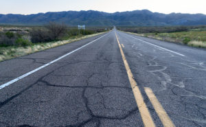
Our home in Congress is on a scenic byway. Each weekend, there are lines of exotic sports cars and motorcycles that pass by our trailer park to prove it. There are several roads— like AZ 89—in our state that offer motorsports enthusiasts a venue to stretch the legs of their beloved machines. I’m sure that the other states have roads like ours. I’m surprised that someone hasn’t compiled an encyclopedia of “The World’s Great Weekend Roadtrips.”

The route passing our home is known as the back road to Prescott because it avoids the weekend traffic on Interstate 17. It’s a longer drive, but that’s not the point. I think this passion is best described in Queen’s song; I’m in love with my car. “. . . get a grip on my boy-racer roll bar . . .” (Yes Virginia, Queen recorded songs other than Bohemian Rhapsody). It’s customary to play this anthem at full volume with the top down and the sun flickering through the pines on to your Ray-Bans.

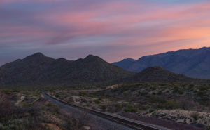
There are actually two ways to get to Prescott from here. The first is to stay on ’89 and drive between the Sierra Prieta and Bradshaw Mountains. The motor-heads like this way because they get to test those big Brembo brakes on their Lamborghinis. This way is challenging to keep up with the speed limit, your up in the pines quicker, and the road dumps you onto Whisky Row, where everyone parks around the courthouse for an impromptu car show.

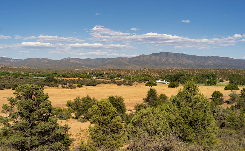
The second option is better if you’re towing a trailer, hauling a load of eggs from Costco, or you’re trying to keep Queen Anne from throwing up in your lap. To go this way, you turn off at Kirkland Junction and pick up Yavapai County Route 10—Iron Springs Road. This route is more docile, as you travel through Kirkland, Skull Valley, and Iron Springs, although it’s a bit trickier to find your way downtown once you get to Prescott.

Kirkland Peak - The run-off from the granite covered mountain has cut into a layer of limestone deposited on an old lake or sea bed.
Kirkland Peak – The run-off from the granite covered mountain has cut into a limestone layer deposited on an old lake or sea bed.

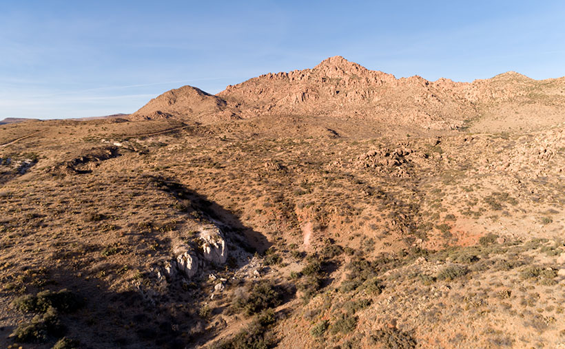
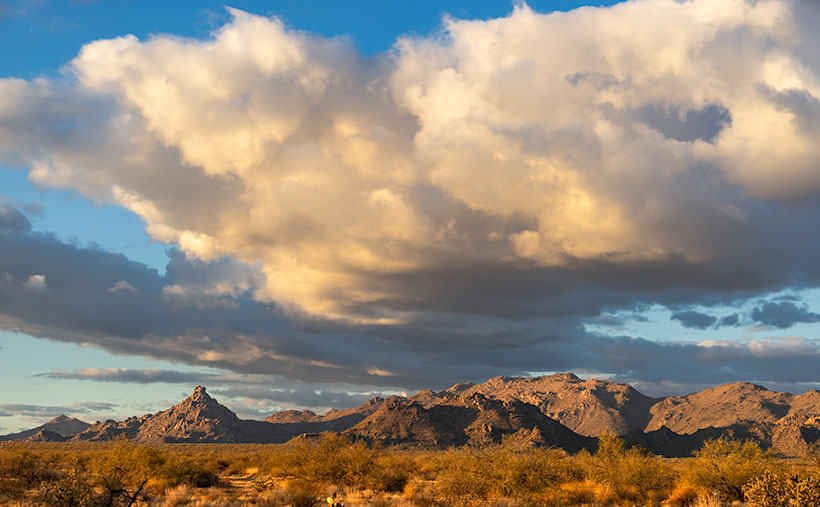
It’s on this second route that you’ll see the subject of this week’s featured image—Kirkland Peak. It will be the rocky mountain filling your windshield at the Kirkland stop sign. There’s even a better view if you drive straight and cross the tracks. But right now, we’re going to turn right onto Iron Springs Road toward Prescott because there’s something else I want you to see.

Soon after leaving the junction, CR 10 follows the railroad tracks and Skull Valley Wash filled with cottonwood trees. In this section—between Kirkland and Skull Valley—there is a cluster of limestone hoodoos where the granite top layer has been eroded. I’ve tried to photograph the outcrops on several occasions, but telephone lines and private property frustrated me. When I visited last week, a new mine has begun setting up operations, and they’ve scraped the land clean. There are two new five-story silos built beside the road, and I’m afraid that the remaining hoodoos will be gone shortly.

When I drove up to shoot Kirkland Peak this week, I was pleased to find a place where the mountain’s run-off has exposed more limestone, as seen in this week’s picture called Kirkland Peak. There are eons of geology exposed in this photo. The bottom layer is an ancient lake or sea bed, covered by granite (lava cooled slowly), and a mountain thrust above them. The evidence of up-thrust is in the grain of its rocks along the ridgeline (you can’t see that on your phone). As Kelly Bundy said, “The mind wobbles.”

You can see a larger version of Kirkland Peak on its Web Page by clicking here. Next week, I’ll bring you another image from our corner of the world.

Until next time — jw

Date Creek Clearing Picture of the Week

Sometimes you get lucky. As a photographer, I keep scenes in my head, so I can go back when the light is right when I want to capture them. That’s what happened for last week’s image, Resting Santa. We had a series of dry fronts move through Congress during the month, but the weather forecasts called for an afternoon where the sky would be clear so the evening sun would pleasantly light up the Harcuvars. I left the house at 3:30 and purposely drove out to get that shot. It was practically a product shot.

More often, I pass by beautiful once in a lifetime scenes that will never be replicated, and I chastise myself for not having a camera with me—or worse—not taking the time to stop. That’s almost what happened with this week’s featured image.

Date Creek Clearing - A clearing winter storm hangs over the Date Creek Range in the evening sun.
Date Creek Clearing – A clearing winter storm hangs over the Date Creek Range in the evening sun.

After I was finished shooting Resting Santa, I drove home on State Route 71. I was looking forward to getting back to a warm home, a nice glass of wine, and one of Queen Anne’s famous home-cooked Stouffer’s dinners. The sun was low on the horizon, and outside my window, a golden cloud hung over the Date Creek range. The conversation in my head went something like this.

“Oh my, that’s gorgeous. I should really come back with the camera sometime when the light is like this.”

“You idiot! Your camera is on the passenger seat, and the light is like this right now. Stop the truck, walk across the road, and take the picture.”

I was very convincing, so I did stop and take a shot—several of them to be exact. The version that I like most is called Date Creek Clearing. There are two prominent peaks in the Date Creek Range; both of them are unnamed. On the left is the rocky pinnacle that ate my first drone, so I call it Drone Eater Mountain. On the right side is the Range’s high point. They are only bit-players in this photo. The real stars here are the clouds caught in a moment that can never be duplicated. Those storm leftovers can never be the same.

I know that my work is considered trivial and will never warrant a Pulitzer Prize or other great awards. I shoot mostly meaningless pretty pictures, valued at a dime-a-dozen. But on a week such as the one we’ve experienced, I needed a bit of calmness and serenity. If you feel the same, then this is my gift to you.

You can see a larger version of Date Creek Clearing on its Web Page by clicking here. Next week, I’ll bring you another image from our small corner of the world. Stay safe.

Until next time — jw

Ferguson Valley Picture of the Week

Queen Anne—as my mother would frequently say—is deaf in one ear and can’t hear out of the other. However, she can tell the difference between me calling, “Anne” and the blood-curdling scream, “Aaannee.” I know this to be true because it happened this week when she rushed to my rescue.

I was busy watering the potted flowers that live on the back deck. We keep them there in the shade during the summer, and I have them arranged on the back doorstep, so the bunnies don’t get to them. It doesn’t work because one or two rabbits will scamper off whenever I open the door. I used my cute water can instead of dragging the hose to conserve water. As I finished the mums, I stepped to the left toward the geraniums. There between the two pots was a western diamondback rattlesnake lying in a wad like a pile of tan rope. It laid there motionless while I involuntarily took a couple of steps backward while I screamed in a voice a couple of octaves higher than my normal range.

When she came to see what the fuss was about, I could only stutter, “porch … snake.” She stepped outside and sized up the serpent, then went back into the house. She quickly returned with a long stick that she had used to knock down a hornet’s nest on the front porch. She marched over to the rattler—which hadn’t twitched yet—took a stance, and began whacking at it. The vermin’s head popped up like it had been sleeping and tried to escape to the left. Anne was too quick and outflanked it, then she took a couple more swings at it. Then the legless reptile reversed course and slithered across the landing before it escaped down a gap between the decking and the house.

“Now what’ll we do? What happens now?” I pestered while dancing from foot to foot like I had to go to the potty. She leaned her stick against the house and went inside and called the fire department. I stood watch, ready to run away the moment I saw any movement. When she returned, she assured me, “They said to leave it alone. It knows it’s not loved and will move on when it feels safe again. If we see it again, we’ll call them, and they’ll come to remove it for us.” I was still upset, and I whimpered while nervously rocking back and forth. That’s when she slapped me across the cheek and commanded me to “Snap out of it.” She went back inside and returned with my camera bag and shoved it into my chest and instructed me to “Shut up and get in the truck. We’ll go take some pictures.”

We drove up the mountain to Skull Valley, where it was cooler. Well, it was under a hundred, and that was better than at home. We turned onto a road named Ferguson Valley Road. The dirt trail is only 6-8 miles long, but there was enough material there to keep me busy in August. The route runs by one cattle ranch and ends at a second. I haven’t found any information about this spot on the map, so I’m surmising that the Fergusons must own one of those places.

Ferguson Valley - Against a backdrop of the Sierra Prieta range, a white ranch-house sits in pretty Ferguson Valley.
Ferguson Valley – Against a backdrop of the Sierra Prieta range, a white ranch-house sits in pretty Ferguson Valley.

Perhaps they live in the home seen in this week’s featured image. I called this photo Ferguson Valley, and I spotted this scene as we crossed over a low ridge. I liked how the white ranch buildings contrasted with the juniper and cottonwood. I also wanted the clouds forming over the Sierra Prieta range. They speak to the feeble start of this year’s monsoon season. In a typical year, there would be spectacular thunderheads building in the mountains surrounding Prescott.

It’s been several days since we last saw Fang—yes, we named it—so we’re more cautious when we’re outside. We assume the snake is out there, and we actively search for it as we move about the yard. We’re careful to keep the garage door closed, and we work as a team when exiting the house. Anne stands with her back to the wall—stick in hand—and when I open the door, she swooshes through it, scans the area, and then yells, “Clear!” The swat-team imitation repeats a couple of times until we’ve safely reached the car. I’m better now, but if we have many more rattlers visit us, we’re moving to New Zealand—if they ever let us in again.

You can see a larger version of Ferguson Valley on its Web Page by clicking here. I hope you like it. Be sure to come back next week to see another image from this pretty little valley.

Until next time — jw

89 Sunrise Picture of the Week

There are two types of drivers on the road. The first type is people trying to get somewhere, while the second group is people who are out for a ride. You’re not always stuck in one group or another. Sometimes you have an appointment to make; while on other occasions, you have all the time in the world. My dad was part of the gotta-get-there group. Once he got in the car, he didn’t stop for anything unless it was gas. Although he was our family’s driver, I don’t think he liked it much.

I’m part of the second group. On a day like today, sunny and temperatures in the mid-seventies, I relish driving an excellent machine down back roads with the windows down so the wind can blow where my hair used to be. These are the times when I feel most alive and free. Nothing beats driving an empty winding road with a hot blond beside you in the passenger seat—even if it’s just my blow-up doll—er, sorry. I got carried away there. I see a time soon when we’ll have autonomous vehicles, and that’s fine as long as I’m not in one.

That brings me to one of our community’s best features—the road leaving town. Up until the Second World War, our trail carried most of the traffic between Phoenix, Prescott, and Flagstaff. At that time it was part of the U.S. highway system, and its designation was US89. After the Highway Department opened the last section of Interstate 17, the Feds depreciated our road, and now it’s officially Arizona State Route 89. During its heyday, US89 stretched between the Mexican Border at Nogales and Canada at Glacier National Park, but today it stops at the US66 junction in Flagstaff.

89 Sunrise
89 Sunrise – The road heading north out-of-town starts by climbing over the Weaver Range at Yarnell Hill.

Now that most of the traffic is on the freeway, SR89 has become a scenic back road that drivers love with low traffic, almost no trucks, plenty of curves, and a variety of scenery. I can prove it. On any weekend you can sit in your lawn chair at our park’s driveway and watch clusters of geezers on Harleys, boy-racers on rice rockets, and waves of sports car clubs headed north on Saturdays and south on Sundays. On weekdays, the proving ground boys’ wiz by driving disguised test cars and trucks. You know they’re having fun because you can see dilated eyes behind their Ray Bans and they have big grins on their faces.

When I thought about this week’s featured image, I wanted the road front and center, and the spot that I chose is where SR89 heads towards the Weavers as if they’re going to crash. They don’t however, because, at the last moment, the road turns right and starts up Yarnell Hill. If you’re traveling in a group, that’s where the race starts—well, actually I don’t need others because I raced in autocrosses—ask Queen Anne.

For this shot that I named 89 Sunrise, I wanted to have my tripod in the middle of the street, so I needed an empty road. That’s why I got there and set up before this morning’s sunrise. The highway is the subject of my image, but the Weaver’s aren’t bad either. In this shot, there’s a lot of green, but in a few weeks, it will turn golden brown.

You can see a larger version of 89 Sunrise on its Web Page by clicking here. I hope you enjoy viewing this week’s post and come back next week when we’ll start a month of featured images from another Arizona place.

Until next time — jw

North Bound
North Bound – An early morning freight train at the Congress Crossing.

PS—As I was finishing up this morning’s shot, I could hear a freight train pulling the Wickenburg grade, some four miles away. So I quickly packed up and rushed down to the crossing and got this image. It’s not the shot that I described last week, but at least it’s a train.

Sunrise on Track Picture of the Week

There are only a half-dozen places Queen Anne, and I frequent in our home town of Congress. There’s Nichol’s West—our favorite local restaurant, the Post Office, the clinic, the Kwikie Mart, and the Dollar Store. Oh, I forgot the dump. For anything else, we have to drive into town or—shudder—the big city. Half of those in-town destinations are on the west side of the railroad crossing, which never has a train—most of the time.

I wrote in a newsletter about our train when we first moved here. This section of track is called the Pea Vine Grade that follows Highway 60 out of Sun City till Wickenburg then continues north to Prescott and Ash Fork. The name is descriptive of the twists along the route.

The tracks aren’t busy like the southern route in Yuma, or the north through Flagstaff. This route isn’t bustling and only has four to six passing trains each day. They’re not on any schedule that I can discern and you don’t hear them go by as much as you feel their bass vibrations, especially the ones coming up the grade. The five engines work hard dragging loaded freight cars up the hill, while the ones headed south sound like a wooden roll-a-coaster as they effortlessly roll downhill. Their horns only blare in Wickenburg and the Congress crossings. That’s too far away to hear from the house unless we’re sitting on the back porch and there’s a north breeze coming off the mountains, but even that’s so faint that it’s like a scene from a Steinbeck novel.

Sunrise on Track
Sunrise on Track – Dawn breaks with a red sky over the railroad tracks heading north from Congress Junction.

This week’s featured image turned out completely different from how I originally visualized it. I wanted to capture this shot with a train in it. The tracks come into Congress Junction from Hillside through the valley between the Date Creek Range and the Weaver Mountains. On most mornings, there’s an early southbound train. We’ve seen it while we’re out for our morning walks. To further set the scene, the Date Creek Range foothills at the crossing are prettiest at sunrise. The rest of the day, they’re flat and dull. So that’s what I had in my mind when I drove there in the dark.

I previously scouted out a lovely spot overlooking the tracks, and I set up my camera and waited for the characters to arrive. As the eastern sky got brighter, the clouds overhead turned red, and I thought, “Ooo shiny.” I fired off a couple of frames. As I waited, the fast-moving clouds moved east and began to block the sunrise removing any drama from my scene. Besides, no trains showed up. Disappointed, I packed up and drove around town looking for other subjects to shoot.

When I got home and reviewed my images, this was the shot that impressed me the most. Even without a train, the tracks are a leading line that moves your eye to the foothills.  The light bouncing from the clouds tints the scene pink, and that light softly brings out the mountain’s cone shape. There is a feeling of tranquility in this shot. It’s a moment of quiet and calm.

You can see a larger version of Sunrise on Track on its Web Page by clicking here. I hope you enjoy viewing this week’s post and next week; we’ll show another featured image from Congress.

Until next time — jw

Rock Frog Picture of the Week

Our adopted town of Congress is a small retirement community, although it wasn’t always that way. Like most of the old mine towns around here, plenty of people lived here as long as they could yank gold out of the dirt; at times, there were even more people here than living in the little farming village called Phoenix. After all the money was gone, there wasn’t any reason to hang around here. The soil’s too rocky to farm, and there’s little to see here.

However, We have one attraction that puts us on the map, and I like to think it came from boredom. I imagined one summer’s day in 1928, and young Sarah Perkins–a homesteader’s wife—was in the shade of their front porch seeking relief from the oppressive heat. As she rocked in her chair, sweat soaked her gingham dress. The glass of refreshing lemonade that she held to her brow felt good as she stared at the pile of rocks across the highway near the railroad tracks. She turned to her husband sitting in the chair beside her and said, “Lester,” (I couldn’t find his name, so I picked one from my head) “The next time you’re in town, I want you to pick me up some green paint.”

Lester was a wise man who knew better than to ask, “What for?” A couple of weeks later, when he returned from town in the Model A pickup, two cans of Sarah’s paint and three large brushes were buried within the other provisions. The very next day, in the cool of the morning, she led her sons across the road to the pile of rocks, and they began to paint.

Frog Rock
Frog Rock – The pile of boulders painted to look like a frog has been a Congress landmark since 1928.

If that’s not how it happened, it’s how it should have been when Sarah created our green rock frog. I agree, it’s tacky kitsch, but it’s our giant ball of twine, our world’s largest ketchup bottle, or our Lucy the Elephant. It’s a point of pride in our town, and when the paint fades, a self-appointed committee repaints it. I think that the Highway Department has given up on removing it, because, like the elephant on Yarnell Hill, it always returns. This last time, they added spots to the frog’s back.

I wanted to show more than just a frog when I shot the frog. I wanted to show how the 50-ton boulder looked unpainted, so I included some granite boulders in the foreground in a supporting role. I call this week’s image Rock Frog partly because I had a B-52 song stuck in my ear.

You can see a larger version of Rock Frog on its Web Page by clicking here. I hope you enjoy viewing this week’s post and come back next week when we’ll show another featured image from Congress.

Until next time — jw

Mobil Antlers Picture of the Week

A long time before we moved here, I remember driving through our little hamlet and noticing the old buildings in town. Queen Anne and I were traveling to visit my folks in Kingman, and after leaving Wickenburg, traffic stopped. Thinking it must be a result of an accident, I said to Anne, “We can detour around it by going to Congress.” It was ten miles out-of-the-way, but at least we’d be moving. It was when we reached the village that I saw the structures and said to her, “That’s so cool. I don’t remember this being a ghost town. I’ll have to come back and photograph it, someday.” (As an aside, my detour didn’t work because the accident was further north on US 93. We finally drove over to the river and took US 95, which put us several hours behind.)

There’s a reason why I didn’t remember those old buildings even though I had gone that way several times before. They weren’t there. After moving to Congress, that someday that I had set aside to photograph Congress’s historic district finally came. When I did, it disappointed me to learn that they’re a fake, like a back-lot movie set. The buildings are empty shells apparently used to display someone’s antique sign collection, but I don’t know why. It’s like someone threw up some structures as a tourist attraction and then quit before finishing.

The area of town at the  AZ 89 and AZ 71 junction isn’t the historic part of Congress. It used to be called Congress Junction or Congress Depot. The historical part of town was up Ghost Town Road near the mine. In this Wikipedia article, there’s a 1914 photograph that shows how it was. When the mine closed in the 1930s, the town moved to today’s location—lock, stock, and barrel. All of the buildings in the photo are gone. The land was scraped clean, including the mine structures. The only thing remaining is the old cemetery and a shed for Stephan—the mine’s caretaker.

Wouldn’t it be nice if someone bought and moved these buildings along the railroad tracks from old town? I don’t know, because there’s nothing to explain their existence. The only remaining business there is someone selling landscape rocks. Maybe you know the story and can share it with us, or perhaps, when I get a ’round-to-it,’ I’ll investigate and post an update.

Mobil Antlers
Mobil Antlers – An antique Mobil Oil flying horse is displayed over a pair of antlers at Congress’s fake garage.

I’ve pretty much ignored this part of town for the past three years, but since we’re featuring Congress during March, I wanted to show you what always catches my eye as I drive by them. It’s the Mobil Oil red flying horse sign. I’d like to have something like it to hang on the gable over my garage door—perhaps a Ferrari, Porsche, or one from Sunoco. To be accurate, however, my sign would be for beat-up Chevy station wagons.

In this week’s featured picture that I call Mobil Antlers, a set of antlers upstage the flying horse, so I concocted a fantastic story about it. It represents a tale about a red horse that soars high in the sky. He spots his prey in the meadow below—a handsome buck. The horse swoops in for the kill, and there’s a mighty struggle with the deer attempting to gore the soft underbelly of its attacker. Red-horse prevails and devours Bambi except for the antlers because they’re indigestible. Then I thought, nah—I’m not going to say that—it’s just too bizarre, and people will think I’m weird.

You can see a larger version of Mobil Antlers on its Web Page by clicking here. I hope you enjoy viewing this week’s image and come back next week when we’ll talk more about Congress.

Until next time — jw