Tom Reed Mine and Elephant’s Tooth Picture of the Week

After publishing last week’s post, I lingered in my office for a while with a nagging question. It was more of a puzzle than a burning issue, but it would persist until I solved it. My enigma was this: If Lt. Whipple completed his survey in 1854, and the railroads were already following his trail, why in 1926 did the Highway Department run Route 66 through a rugged mountain pass when they established the National Highway system? Wouldn’t it be faster and cheaper to follow the railroad tracks down to the Colorado River? I used up over half of my monthly Google query allotment trying to understand their logic. After distilling some facts that I uncovered, and with some fantasy time travel, I concluded that the department wanted travelers to go through the shining city on the hill—Oatman. When the mines were still open, Oatman was a bustling city, with a good hotel, restaurants, bars, groceries, and gas stations.

Oatman Main Street 2020 - The crowds of tourists are gone, the stores are shuttered, and even the burros are social distancing.
Oatman Main Street 2020 – The crowds of tourists are gone, the stores are shuttered, and even the donkeys are social distancing.

Arizona has two types of ghost towns, and to paraphrase a line from Frank Zappa’s song Camarillo Brillo, there are real ghost towns, and there are Walmart ghost towns. Real ones are scattered throughout Arizona’s mountains and plains. Places like Cochran, Cherry, and Ruby. If you drive there in your Jeep, you’d be lucky to find a standing building, but—most of the time—only their crumbling foundations remain. As for the latter towns, they’re thriving communities. Arizona’s big four include Jerome, Tombstone, Bisbee, and Oatman. People still live there, and more importantly, tourists visit by the busload. They come to drink in the saloons, eat lunch in the bordellos, watch the fake gunfights, ride oar carts into the mine shafts, and feed the wild donkeys. I wouldn’t be surprised to learn that these towns generate more annual revenue today than the mines ever did.

Before my first Oatman visit, I already knew the image that I wanted to take. Ansel Adams—the photographer that most inspired me—had already made it. Mr. Adams must have blackmailed God because he had Him move heaven and earth into compositions that no other mortal photographer ever saw. The photo that I’m referring to is in one of his books and is called Tom Reed Mine, near Oatman, Arizona. It shows a cluster of buildings on enormous washtubs with a pinnacle in the background. When I was younger, I tried to visit the places he captured so I could see what motivated him. That was my way of learning from a master. But in all my visits, I never found those impressive mine structures.

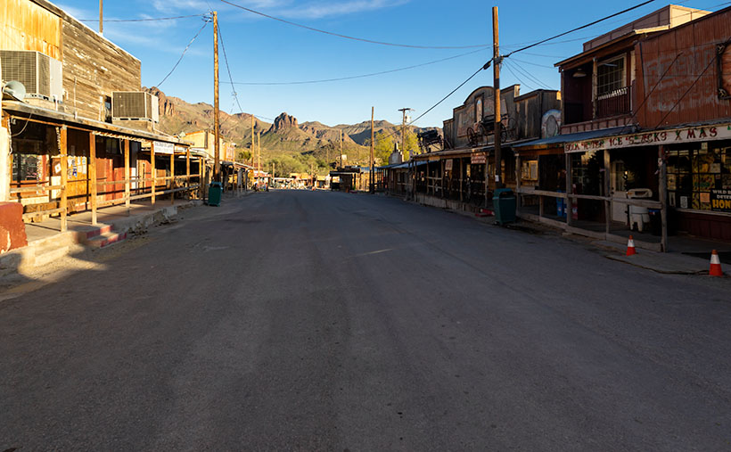
When Queen Anne and I made our Route 66 journey last month, snapping pictures in Oatman was the last thing I wanted. We were avoiding people, so stopping in a crowded tourist trap was out of the question. But when we arrived, the streets were empty of people wearing funny hats, loud shirts, sandals with black socks, and speaking in foreign tongues. The merchants had shuttered the windows, and even the wild burros—the stars of the Oatman experience—were social distancing. I had to stop and document this weird moment—Oatman had turned into a real ghost town.

Tom Reed Mine and Elephants Tooth - The concrete foundations are all that remain of the magnificent structures that Ansel Adams photographed.
Tom Reed Mine and Elephants Tooth – The concrete foundations are all that remain of the magnificent structures that Ansel Adams photographed.

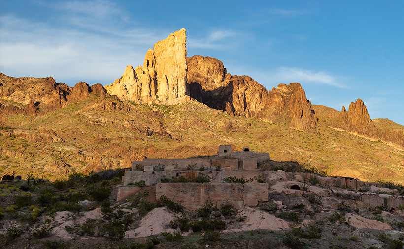
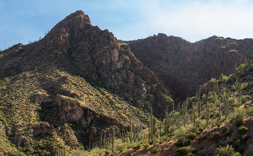
As we drove out of town through the south side, the sun was low in the sky and casting lots of color on the hills—including the pinnacle that Adams captured. I stopped on the road where some concrete foundations lined up below the white outcrop—that I now know is called Elephant’s Tooth—and took this week’s featured image. I call it Tom Reed Mine and Elephant’s Tooth. We spent less than 15 minutes at that location before driving on.

Since we’ve been home, I was curious about the Adams photo, so I got it down from the bookcase and searched for his rendition. I wanted to see the buildings that he shot again. I’ve never been able to find them no matter how much I scoured the town. Upon examining his image, I realized that he took that photo in 1952, and people have since torn down the structures. The only trace of their existence is the concrete terraces in my picture. When I took my photo, I stood within ten feet of where Ansel Adams worked his magic, and we were both inspired by the same subject. I was so close to being in the presence of greatness—I only missed him by 68 years. My life can go on now.

You can see a larger version of Tom Reed Mine and Elephant’s Tooth on its Web Page by clicking here. I hope you enjoy it. Next week, we’ll pass by the Warm Springs Wilderness on our way to the Colorado River. I hope you’ll join us then.

Until next time — jw

Cholla Bay Picture of the Week

After being stopped by a river that rarely has flowing water, we spent some time along the bank of the Big Sandy, watching the calm, almost clear water flowing on its way to Alamo Lake. Queen Anne broke out a couple of water bottles, and we shared a trail bar while perusing the map to find our options.

This would have been a perfect picnic spot if we had packed a basket. Imagine sitting on a blanket in the middle of 17 Mile Drive, where it disappears beneath a river. We could see a couple of houses nearby, and later, I found out that we were in Greenwood—the site of yet another abandoned mining community. In its heyday, some three hundred souls lived and worked here. The town—named after the abundance of Palo Verde trees—didn’t last long because of its low-quality ore.

We turned around and started our journey home with the day getting late. We dallied along the way, making many stops for photos. Before the road began the ascent up the mountain, I spotted where the Big Sandy River had scoured 30-foot cliffs out of the mud banks. The formation was nearly circular, and you could imagine the raging water churning in a back eddy, a swirling whirlpool flowing against the river’s current. A large grove of Teddy Bear Cholla was growing inside the containment, so I grabbed my camera and hiked in for a shot.

Cholla Bay - The most dangerous cactus will attack you at the slightest provocation.
Cholla Bay – The most dangerous cactus will attack you at the slightest provocation.

I have a love/hate relationship with the cholla cactus. When backlit, it has a soft fuzzy look that makes you want to jump into it like a pile of autumn leaves. It’s also known as Jumping Cholla, but it doesn’t do that. Its outer joints are fragile—hair trigger, if you will—and the tips break off from the main plant with the slightest disturbance. The needles are barbed, so if you get some into your skin, you have to pull them out with pliers—one by one.

Whenever I’m near Cholla, I move slowly and cautiously. I watch the ground for snakes, cow pies, and cholla balls. It’s like walking a tight wire. I don’t look up until I stop walking. So imagine how startled I was in the middle of this field when a wild gray burro popped his head up and snorted. He was just as frightened as I was and quickly galloped off to the far side of the road, but it took all my self-control not to stumble back through the cactus patch. Once the two jackasses safely separated, I regained my composure and took this picture, which I called Cholla Bay.

You can see a larger version of Cholla Bay on its Web Page by clicking here. I hope you enjoy viewing it. Join us next week when we finish our trip to the Poachie Mountains.

Until next time — jw

Sun Showers Picture of the Week

The day was getting late, and before Fred and I could go back, we needed to find one final pass to cross and return to Silverton—and eventually Durango. When we stopped to enjoy Lake Como—last week’s photo—it turns out that we were already near Hurricane Pass. Unlike the other passes, we didn’t have to crawl down one mountainside and up another. Instead, the road followed the ridgeline for a half-mile, and voila.

Unfortunately, Hurricane Pass wasn’t as photogenic as the others that day. The road simply turned east for a bit before disappearing down a crack. Of course, the crack opened into a gulch, then a river valley as we descended 5,000 feet into civilization. It was an anticlimactic way to end the day. The trail was soon gravel followed quickly by asphalt; with guardrails, of all things.

Sun Showers - Although small clouds filled the sky, the only rain we got was a sun-shower.
Sun Showers – Although small clouds filled the sky, the only rain we got was a sun-shower.

But don’t worry, I come bearing gifts. All during our outing, puffy little clouds filled the sky. They seemed to bump into one another like the balls on a billiard table. Then they would part again leaving large patches of blue sky. On our way down the hill, it started to rain—while the sun was shining. As we rounded a bend in the road, the sun appeared in one of those patches and backlit the mountainside. It’s one of those moments where the grass becomes iridescent and glows. I’ve seen this before in New Zealand. I failed to capture it there, but I think this week’s image is close. I call it Sun Showers. The mountain that we’re looking up as maybe Hurricane Peak, but I’m not sure. In case you’re wondering—yes, those are the Sun’s rays at the top. Did I tell you about the steep angles we experienced during this trip?

You can see a larger version of Sun Showers on its Web Page by clicking here. Be sure to come back next week when I’ll show you my favorite image from our adventure exploring Colorado’s San Juan Mountains in Fred’s Toyota—oh, sorry—Fred’s Jeep.

Until next time — jw

Lake Como Picture of the Week

Lake Como as seen from the top of Calaifornia Pass.Lake Como – A little alpine lake from California Pass in Colorado’s San Juan Mountains.

Something is intoxicating about standing on a mountaintop. You get a sense of accomplishment—an incredible buzz—while taking in the view. As you spot familiar landmarks, the map you carry around in your mind gets updated. I can understand the addition mountain climbers have to the highest peaks. I’m just too lazy to be one of them, and you won’t catch me on the climbing wall at the local gym—or inside the gym in the first place. Spending a day with Fred driving his FJ up-high passes in the San Juan Mountains was good enough for me.

When we decided not to spend all day driving Colorado’s Alpine Loop but drove up two of its passes, we wanted another challenge. The first ascent was scary, while the second was not so much. I felt like a kid on a swing urging his parents to push harder. “Again,” I shouted. So, we stood on Engineer Pass with the map spread over the hood, looking for another route back to Silverton. After all, we didn’t want to go back down the way we came. That was along the Animas River and was flat and dull. We agreed on a route that would take us over two more passes before dropping back to Silverton via Cement Creek, and that meant that we’d have first to drive back down to Animas Forks.

From the ghost town, we headed west up California Gulch. Going in this direction, the road ran straight ahead for several miles and appeared to end midway up California Mountain. Several times, I’ve traveled roads without a clue what’s ahead. For example, Interstate 15 is heading north out of Mesquite, Nevada. As it leads for the Beaver Mountains, you can’t pick out where the freeway climbs over them. I always involuntarily back out of the gas in case the road suddenly ends—like against the mountainside. At the very last moment, the Virgin River Gorge opens and swallows the highway. I was getting that feeling now.

It wasn’t until the perceived end of the road that it turned on itself and climbed behind a side ridge that hid the route from below, and as we drove around the bend, the trail went vertical. I questioned our decision to go this way because this was undoubtedly the beginning of the roller coaster from hell. Fred managed to keep all four wheels on the ground while his truck grunted its way up the grade. When we reached the top, as with the other passes, there was a spot to park and look around. When I got out, I decided a box of Depends would be a handy accouterment on these trips.

But the view! The light was coming in, and there were great shots back at California Gulch, and in front was this pretty little alpine lake—Lake Como—on the other side. I have seen pictures of places like these in magazines, but I’ve never been to one. It was breathtaking—well, 13,000 feet is stunning enough, but you know what I mean. I snapped several variations of this photo, and we eventually drove down to the lake where Fred tried to park over an open mine shaft, but that’s another story. This week’s featured image is the version I liked best because of its composition and color details. I call it Lake Como. I hope you like it.

Don’t let your eyes miss out—feast them on an even grander version of Lake Como right here (Jim’s Page)! Buckle up because we’re diving back into Colorado’s enigmatic San Juan Mountains aboard Fred’s Toyota next week. Trust me, you won’t want to miss this!

Until next time — jw

Salvation Peak Flag Picture of the Week

Castel Hot Springs Resort
Castle Hot Springs Resort – Originally built in 1896 by the owner of the Congress Mine -Frank Murphy – will reopen in October, so cash in your IRA and visit. I believe the tarp is covering the garden where the chief grows fresh vegetables for the restaurant.

It doesn’t much matter which way you travel on Castle Hot Springs Road, either clockwise or the other way, will get you to the historic retreat—the luxury resort for the rich and famous built in 1896. Your choice of travel depends on whether you want to drive through the mountains via Morristown or north from Lake Pleasant via Castle Creek. As a history buff, I prefer the original route, but I also live closer to the old railroad depot, and I’m too lazy to drive that distance to Lake Pleasant.

After I moved to Arizona, I heard stories of the ghost resort from friends, but I didn’t lay eyes on it for thirty years. After the last of my infamous station wagons was totaled while it was parked in the Sun City Boswell Hospital parking lot, we replaced it with my first SUV—Shadowfax. It was an Olds Bravada with ground clearance and four-wheel drive good enough to begin exploring back roads. One of my first outings was to Castle Hot Springs. As a film shooter back then, I didn’t have a perfect shot of the main house, so I didn’t bother taking any pictures.

There’s quite a bit of history that would make good stand-alone stories. Trivia like:

  • The hot spring found by Ft. Whipple Calvary soldiers tracking bandits.
  • Frank Murphy—the Congress Mine owner—bought the land, built the buildings, and then paid for the road.
  • The resort thrived during the first half of the 20th Century catering to the likes of the Roosevelts, Rockefellers, Vanderbilts, Wrigleys, Zane Gray, and Clark Gable (there had to be famous actresses that visited too, but I didn’t discover any of their names).
  • Murphy’s brother—when he was the territorial governor—turned the resort into Arizona’s Mar-A-Lago because winters were too cold in Prescott. And because Warren Murphy ran the state from here, Arizona’s first telephone was installed in the hall of the main building (I believed it survived the ’76 fire).
  • The temperature of the hot springs water is 12oº, which is the same as every Phoenix household during summer.

There’s another more interesting story, however. During the Second World War, the resort was dark because of rationing and shortages. After the war ended, Walter Rounsevel—then owner and general manager—leased the property to the US Military as a recovery and rehab facility for injured officers. One of those officers was a young lieutenant whose back was injured after a Japanese destroyer rammed his PT boat. The officer’s name was John F. Kennedy, and he spent several months recovering at Castle Hot Springs soaking in the springs, hiking trails, and golfing.

Salvation Peak Flag - For providing a place for injured servicemen to recuperate during World War II, the Castle Hot Springs Resort got special dispensation to fly an American Flag on Salvation Peak 24 hours a day.
Salvation Peak Flag – For providing a place for injured officers to recuperate during World War II, the Castle Hot Springs Resort got special dispensation to fly an American Flag on Salvation Peak 24 hours a day.

For its part in helping with the recovery of these servicemen, a special dispensation was given to Castle Hot Springs to fly an American flag 24 hours a day atop Salvation Peak. The flag is visible along the road before and after passing the resort, and I took several shots of it even though the sun was directly behind. My favorite version is this week’s featured image, and I call it, Salvation Peak Flag. Although it looks formidable, Salvation Peak is a smaller outcrop of Governors Peak which is located within the Hells Gate Wilderness area.

You can see a larger version of Salvation Peak Flag on its Web Page by clicking here. Be sure to come back next week when we’ll present our final photo that I made on my Castle Hot Spring Road outing.

Until next time — jw

Rock Frog Picture of the Week

Our adopted town of Congress is a small retirement community, although it wasn’t always that way. Like most of the old mine towns around here, plenty of people lived here as long as they could yank gold out of the dirt; at times, there were even more people here than living in the little farming village called Phoenix. After all the money was gone, there wasn’t any reason to hang around here. The soil’s too rocky to farm, and there’s little to see here.

However, We have one attraction that puts us on the map, and I like to think it came from boredom. I imagined one summer’s day in 1928, and young Sarah Perkins–a homesteader’s wife—was in the shade of their front porch seeking relief from the oppressive heat. As she rocked in her chair, sweat soaked her gingham dress. The glass of refreshing lemonade that she held to her brow felt good as she stared at the pile of rocks across the highway near the railroad tracks. She turned to her husband sitting in the chair beside her and said, “Lester,” (I couldn’t find his name, so I picked one from my head) “The next time you’re in town, I want you to pick me up some green paint.”

Lester was a wise man who knew better than to ask, “What for?” A couple of weeks later, when he returned from town in the Model A pickup, two cans of Sarah’s paint and three large brushes were buried within the other provisions. The very next day, in the cool of the morning, she led her sons across the road to the pile of rocks, and they began to paint.

Frog Rock
Frog Rock – The pile of boulders painted to look like a frog has been a Congress landmark since 1928.

If that’s not how it happened, it’s how it should have been when Sarah created our green rock frog. I agree, it’s tacky kitsch, but it’s our giant ball of twine, our world’s largest ketchup bottle, or our Lucy the Elephant. It’s a point of pride in our town, and when the paint fades, a self-appointed committee repaints it. I think that the Highway Department has given up on removing it, because, like the elephant on Yarnell Hill, it always returns. This last time, they added spots to the frog’s back.

I wanted to show more than just a frog when I shot the frog. I wanted to show how the 50-ton boulder looked unpainted, so I included some granite boulders in the foreground in a supporting role. I call this week’s image Rock Frog partly because I had a B-52 song stuck in my ear.

You can see a larger version of Rock Frog on its Web Page by clicking here. I hope you enjoy viewing this week’s post and come back next week when we’ll show another featured image from Congress.

Until next time — jw

Swilling Cabin Window Picture of the Week

This week’s story has all the ingredients of a great Hollywood western movie: plantations, young love, war, drugs and alcohol, heartbreak, gold, bright futures, despair, stage robbery, friendship, false accusations, and tragic death. I don’t know how I can tell it all in 500 words and still explain my weekly photograph by the third paragraph. I’ve found several books and articles about Jack Swilling, but there haven’t been any films. That’s a shame because I can visualize told in the fashion of the Steve McQueen movie Tom Horn.

Swilling Cabin Window
Swilling Cabin Window – Jack and Trinidad’s cabin ruins in Black Canyon City are on private property, and its caring owners are its only protection.

Every school kid in Phoenix knows how Jack Swilling—or one of his friends and crew, Phillip Duppa—tossed out the mythical bird’s name for the small town they were developing. For the rest of you, Swilling filed a land claim around present-day 32nd Street and Van Buren Road. He wanted to grow hay to sell to the cavalry at Fort McDowell, so he copied the Hohokam method of using Salt River water for the fields by digging new canals to his property. The visionary Swilling (I suggest casting a 20-year-old Jeff Bridges) played an essential role in the layout and alignment of the new town. A couple of years later he lost interest when the council—or whoever decided those things back then—moved downtown three miles west to its present site. Jack threw his hand up in disgust and he and his wife, Trinidad (my casting idea would be a 17-year-old Natalie Wood), moved to Gillett—a mining ghost town three miles south of Black Canyon City.

In Gillett, they built a cabin along the stage route and provided travelers and horses food, water, and rest. It helped to supplement his paultry mining income. His health was failing from old head and bullet wounds he got as a younger man. He took morphine and drank whiskey to counter the constant pain, but now the drinking got worse. When he got word that Colonel Jacob Snively—his old Indian war buddy—was killed near Wickenburg by Apaches, Trinidad encouraged him to retrieve the body and give Jacob a proper burial. Jack enlisted the help of a couple of neighbors and rode out to recover his friend. During that same three-day period, a stagecoach was robbed—also in Wickenburg—and the robbers murdered everyone on board. After Jack returned and buried his friend, he was at the bar when he heard about the stagecoach massacre. Jack cracked a joke about how robbing the stage is the only way to make big money these days, and the vague description of the robbers could include his retrieval party. They were arrested on the spot and shipped off to Prescott for trial. Since the Feds had charged him too, the territorial government dropped their complaints to save money. The marshalls transferred Swilling to the Yuma prison where his health took a turn for the worst, and he died before his trial. Shortly after his death, the law identified and caught the real robbers. Jack was already buried in the Yuma Prison cemetery before they notified Trinidad of his death.

When I decided that October’s subject would be Black Canyon City, I did my research, and there, I discovered the cabin ruins were in town. I wanted to photograph them, but they’re not on a map. That’s because they’re on private property and not open to the public. I stopped and talked to the tourist info people, and they gave me directions to the house, and when I drove up to the residence, the owner came out and chatted with me. When her parents built her home, they bought adjoining lots so that the stacked-stone cabin could remain intact. Black Canyon City doesn’t protect historic sites as other cities do, so they took that task upon themselves. She gave me permission to roam the property and to photograph the cabin with two caveats: don’t lean on the walls—they’re fragile and will quickly crumble, and don’t take any of the artifacts she has on display. A very reasonable request, I’d say.

Of the shots I took, I liked this variation best because of the window and the light filtering through the mesquite trees. Jack’s one-room cabin may not seem like the palace that the Father of Phoenix (and Mother) should have lived in, but just examining the rock-work made my sciatica nerve go off. It’s on a quiet cul-de-sac surrounded by modern homes near the Agua Fria River. I stood for a while and listened to the breeze blowing through the tree canopy, and I could see how it might have been to live there a century and a half ago.

You can see a larger version of Swilling Cabin Window on its Web Page by clicking here. I hope you enjoy viewing this week’s post and come back next week when we’ll show another featured image from Black Canyon City. “Oh!” you say. “But Grandpa, what about the rest of the story—where are the parts about the plantation, the Mexican-American War, the Confederate Lieutenant, Peeples Valley, Rich Hill, et al.” Well, you’ll have to wait for the movie or pick up a book.

Until next time — jw