Geologic Puzzle: Unearthing Whitney Pocket’s Sandstone Secrets Picture of the Week - Mesquite, Nevada

Brown layered Navajo Sandstone uplifted and eroded by fault activity in Whitney Pocket, with unusual rounded edges and color variation.
Geologic Puzzle: Unearthing Whitney Pocket’s Sandstone Secrets – Nature’s Tilt: Witnessing the Story of Uplift and Erosion in Whitney Pocket’s Sandstone Layers.

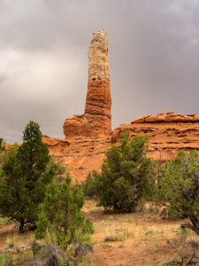
Arriving at a new location like Gold Butte ignites a whirlwind of excitement in me, and my initial instinct is to capture everything in sight. This flurry of photography is more about immersion than precision, leading to a digital pile-up that I inevitably sift through, discarding the excess like chaff. Unlike the costly days of film, where each shot was a precious commodity, the digital age allows me to indulge in this initial creative outburst, knowing it’s part of reaching the true gems.

Once the initial rush subsides, I transition from capturing to contemplating, delving into the ‘why’ and ‘how’ of the landscape before me. It’s here that Shawn Willsey’s geology videos come into play. As a professor at the College of Southern Idaho, Shawn has a gift for demystifying the complexities of earth science, guiding even the uninitiated through geological wonders. His explanations, particularly his Random Roadcuts segments, clarify unusual layering and erosion and bring a new depth to my photographs, transforming them from mere images to stories set in stone.

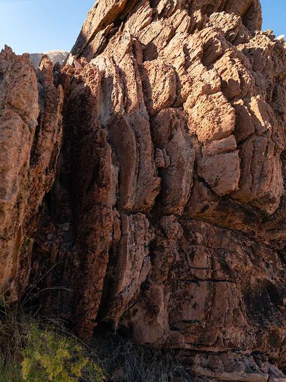
From a distance, the formation in the picture above looked like the blades of a turbine engine embedded in the Navajo Sandstone. For all I know, there is a 747 out there with the guts missing from one of its engine cowlings. The brown color, multi-layers, with rounded edges, stood out like the red marks on one of my term papers. How can I tell you about it when I haven’t a clue? So, I emailed Professor Willsey and asked if he’d look at my photo—and he accepted. He answered, “The feature in question is not a vein but appears to be an upturned section of Aztec (Navajo) sandstone. The near vertical layering is the cross beds deposited on the dune field’s backside (downwind) side. Some faults and other structures in this region of NV are likely the culprits that have tilted the rock layers. Very cool.” Then, he returned to hosting his live coverage of this week’s Iceland eruptions. Now, don’t you feel smarter?

A butte in Whitney Pocket with layered Navajo and Entrada sandstone, with the red end facing south, creating a 'Neapolitan ice cream' effect in the desert.
Neapolitan Earth: Unraveling Whitney Pocket’s Colorful Geology – Stratified Delight: The Neapolitan Butte of Whitney Pocket, where Geology Meets Gastronomy.

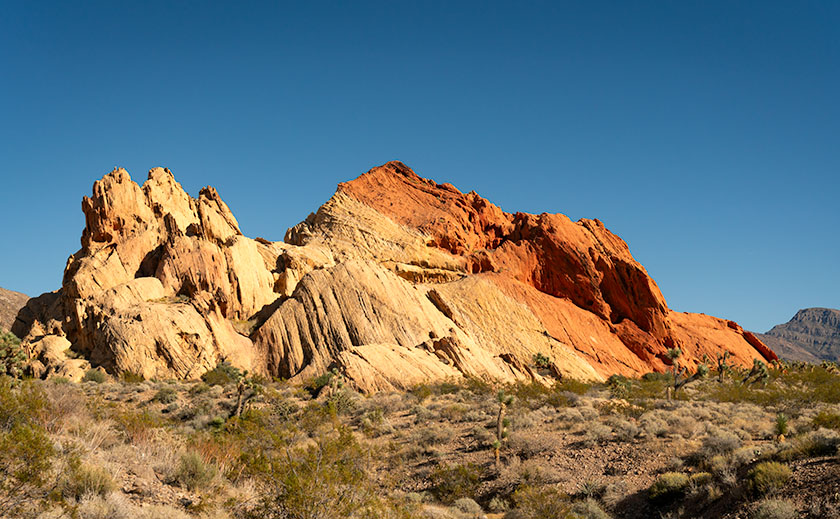
There’s a question in this week’s other picture as well. It’s an image of a sandstone formation that looks like a bowl of Neapolitan ice cream after Queen Anne was done with it. I say that because Queen Anne always eats the chocolate and turns her nose up at the rest. The issue is that the red section appears on the white layer. From all I’ve read, the Entrada era—with its rust-colored sandstones—came before the white dunes. My best guess is that the forces that lifted the Virgin Mountain Range over a mile in the air also jumbled the natural order in this basin. What are your thoughts?

I have posted larger versions of Geologic Puzzle on my website < Jim’s Web> and my Fine Art America page <FAA Link> should you want to examine the layers closer. Next week, we wrap our foray into Gold Butte National Monument with one of the rare evidentiary remnants that anyone preceded us. It’s like unearthing the Spinx. Join us then, won’t you?

Until next time, keep your spirits high and your humor dry.
jw

BTW:

As we gather to celebrate the holiday season, Queen Anne and I would like to extend a hearty Seasons Greetings to all of you. Whether you’re out there chasing the perfect light or cozening up at home with loved ones, may your days be merry, bright, and filled with the joy of discovery. Here’s to capturing more beauty, sharing more stories, and creating unforgettable memories in the year ahead.

Kodachrome Pipe Picture of the Week

When exploring Utah’s State Route 12, you really must take time for a side trip to Utah’s Kodachrome Basin State Park—20 miles east of the Bryce Canyon entrance road. Kodachrome Road runs among the cattle pastures from Cannonville to where the pavement ends and the park entrance. There is a small entry fee which you pay at the visitor’s center. If you’re camping, the park’s sites are coveted and the restrooms have flush toilets, hot and cold water, and they’re heated in winter.

Kodachrome Pipe
Kodachrome Pipe – Sand pipes are unique to Kodachrome Basin State Park and there are over sixty of them to photograph. All you have to do is find them all.

I’ve written about Kodachrome Basin in my newsletters before because it’s a favorite destination of ours. Located on the valley floor below Bryce Canyon, the elevation is three-thousand feet lower, so in winter it doesn’t have a bitter cold you’ll find back up on the hill. But it also means that summers are warmer and the temperature can crack the century mark.

Surrounding the park are tri-colored cliffs—red, white, and gray—the same colors that make up the middle three stairs of the Escalante Grand Staircase. Unique to Kodachrome Basin is its sand pipes. It’s thought that millions of years ago, this area was like Yellowstone with geysers and hot springs and as the basin sank into a shallow sea it was covered with layers of sand. The geyser’s immense pressure forced fractures in the hardening sandstone and drilled vents. Then, as the plateau rose, rivers cut into the soft sandstone leaving the hard stone pipes behind. There are over sixty pipes in the park for you to find and photograph (hmm, sounds like a book idea). The one in this month’s featured image is on a shelf overlooking the campground like a trophy on display.

Our Kodachrome visit on this trip was by accident. Each day, afternoon thunderstorms kept us off the dirt roads we’d planned to explore. Because the park roads are paved, we changed plans and wasted some electrons photographing Kodachrome Basin in the rain. My first observation is that the colors are duller when they’re wet. My second was that the trails were muddy and the washes were running so we stayed near the roads. I’ve photographed this pipe before but wasn’t happy with the result. This time, I think I have an interesting shot for you. I call this image Kodachrome Pipe, but I may have to begin numbering them in the future. Because it was so overcast, I wasn’t aware that I was shooting directly at the sun—the bright area in the photograph’s sky. While I processed the image, I tried forcing the clouds to be darker, and when I did, the sun’s disk began to show including a rainbow ring around it. The results didn’t look natural, so I dialed it back to this version.

You can see a larger version of Kodachrome Pipe on its Web Page by clicking here. I hope you enjoy viewing this week’s post and come back next week—a new month—when we’ll start a new series from a different place.

Until next time — jw