Nature’s Palette: Exploring the Red Sandstone Masterpiece at Valley of Fire Picture of the Week - Valley of Fire State Park, Nevada

Red sandstone formations at Valley of Fire State Park, symbolizing the beauty of geologic processes over millennia.
Red Dune Wall in Valley of Fire—A Study in Erosion and Time – The ‘Red Dune Wall’ is a testament to nature’s artistic hand, sculpting the Valley of Fire State Park landscape through the relentless forces of wind and water.

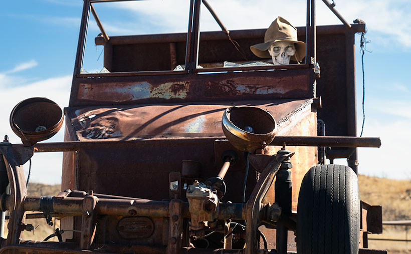
Greetings from the Nevada desert, where Queen Anne (aka Lefty) and I embarked on a wild escapade, armed with nothing but our cameras and a sense of adventure that’s as robust as my morning coffee—deceptively strong and slightly bitter.

It all began in a Mexican restaurant in November, where we had planned to wrestle with the wilds of Gold Butte National Monument. But as we surveyed our gear, we realized we were about as prepared as a fish on a bicycle. With a sigh that echoed off the terracotta walls, we decided to pivot faster than a gambler on a losing streak.

So there we were, poring over maps and munching on nachos when the Valley of Fire State Park flickered onto our radar like a beacon of salvation—or at least a beacon of cell service and paved roads. It was a unanimous decision, fueled by the promise of not getting stuck and the allure of a good story to tell.

After a hearty debate over hash browns and highway maps at Peggy Sue’s Diner the following day, we plotted a less ‘Oregon Trail’ course and more ‘Sunday drive.’ We planned to loop through Overton, graze the shores of Lake Mead, and enter the Valley of Fire from the east, with a sunset deadline to beat the buffet back in Mesquite.

On a whim, we decided to pay our respects to the submerged ghost town of St. Thomas, which was now high and dry thanks to the ever-thirsty sun. The remains were intriguing, but we passed on the hike, preferring to keep our boots dust-free. Instead, I hatched a master plan to lure our friends—the Poteets—into a Jacques Cousteau-style watery charade involving wetsuits and mock-panicked flailing for a film I’d tentatively titled The Great St. Thomas Aquatic Caper.

A towering rock formation known as Silica Dome against the clear blue sky in Valley of Fire State Park.
Silica Dome—The Sentinel of Valley of Fire’s Rocky Landscape – Experience the ‘Silica Dome’ grandeur at Valley of Fire State Park through this captivating image, highlighting the intricate layers and history etched in stone.

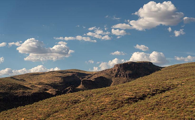
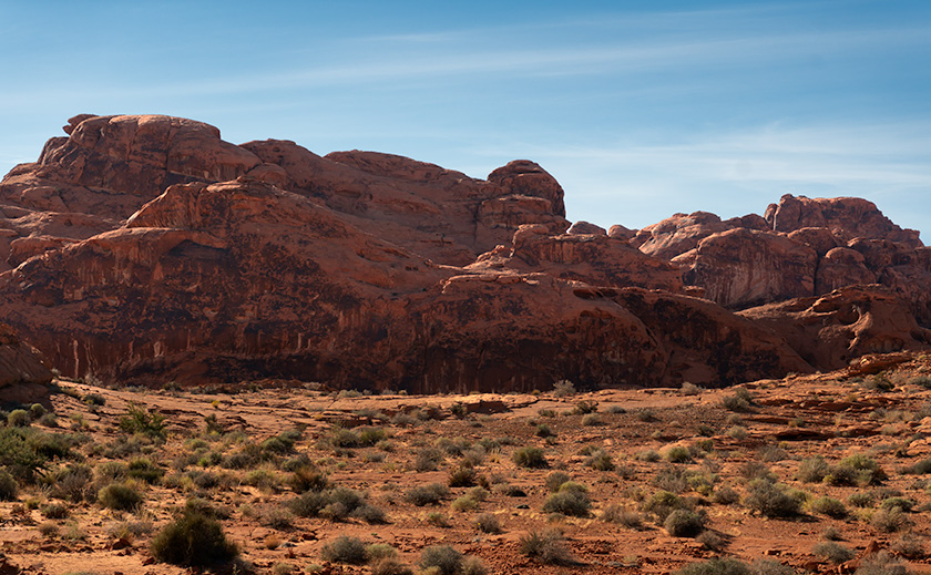
As the day wore on, we wandered among the storied stones of the early Jurassic Era. Like Whitney Pocket, these rocks were part of a grander narrative, a to-be-continued tale of petrified dunes stretching from Zion to the Grand Staircase and beyond. The Valley of Fire’s chapters were penned in red Aztec sandstone hues and crowned with white Navajo crests, a chronicle of time written in Earth’s hand.

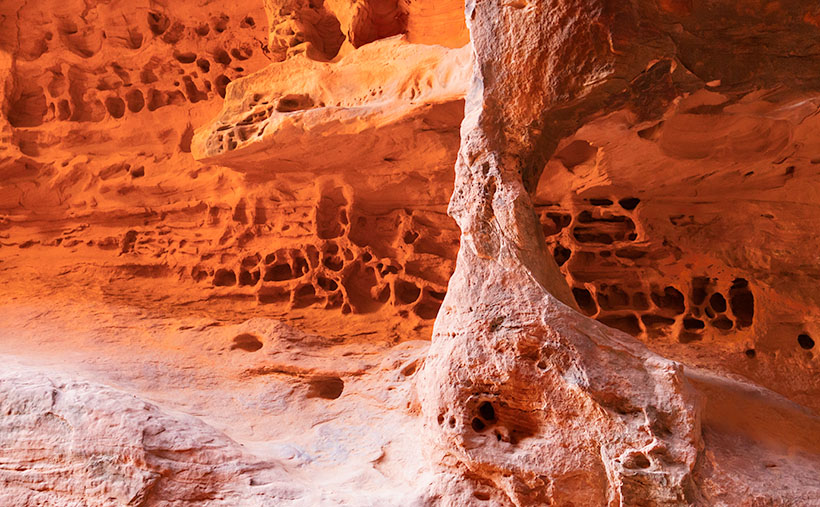
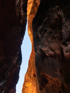
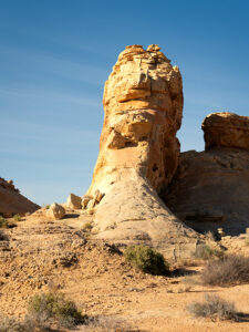
This week’s photographic heroes are a testament to this fiery anthology. The main photo—a regal formation of red Entrada sandstone—is the park’s namesake, standing proudly amidst the Mojave’s scrappy flora. The supporting act, Silica Dome, wears a coat of Navajo Sandstone, pale and majestic against the desert sky. Together, they tell a story of a sea that once was and dunes that danced in the wind before time turned them to stone.
So, dear readers, come for the photos, stay for the tales, and return next week for another chapter in our desert saga. Will the Poteets make a splash in their wetsuits? Will Queen Anne ever forgive me for the early morning escapades? Find out in the next installment of our arid adventures.

Until then, keep your lenses clean and your humor dry.
jw

Techniques Unveiled: A Tale of Two Sandstones

In the photographer’s toolbox, contrast isn’t just about light and shadow—it’s the story of elements, epochs, and the Earth’s grand design. This week, I set out to capture a tale of two sandstones, a narrative etched into the very landscape of Valley of Fire State Park.

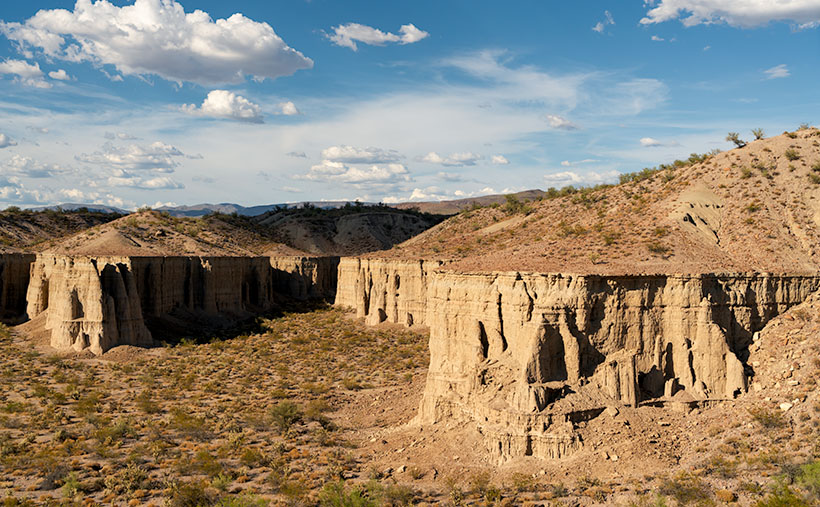
Our lead image, Nature’s Palette, is a canvas painted with iron-rich sandstone, a souvenir from the mid-Jurassic era. Here, the dunes are frozen in an eternal dance, caught mid-twirl by the relentless grip of pressure and heat, akin to the timeless beauty of Canyon de Chelly and the famed arches of Moab. Look closely, and you’ll see the canvas of the ancients—the water-stained varnish that once served as a blackboard for the Fremont and early Pueblo people to etch their indelible art.

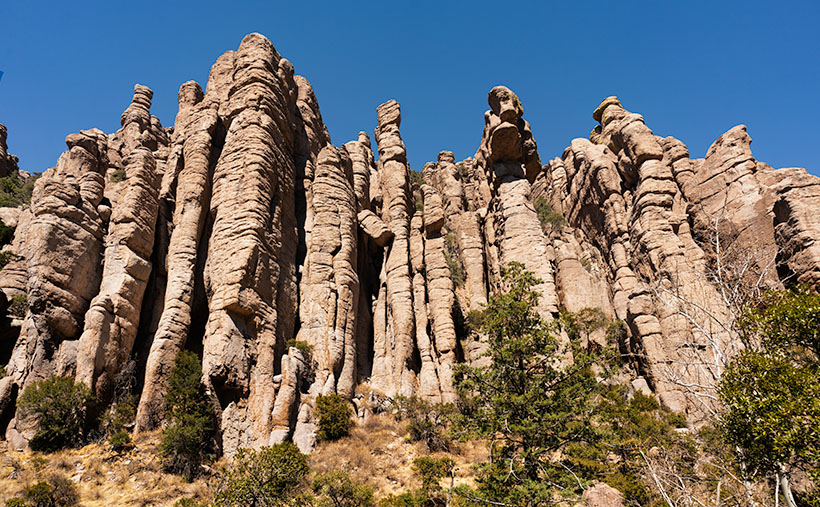
The supporting act, Silica Dome, steps onto the stage from a later act in Earth’s drama under the watchful gaze of T-Rex and company. It’s a piece of the past where the climate was as dry as a prohibition-era bar, and vast sandy beaches fringed an ancient inland sea. In this shot, we confront a dune face-to-face, observing its neighbors’ retreat under the onslaught of time, exposing it to the elements that now conspire to return it to its granular beginnings.

I’ve served up larger versions of these geological delicacies online for those hungry for more than just a visual snack. You can feast your eyes on them via the links on my website—< Jim’s Web Page>—and their respective galleries on Fine Art America—<FAA Link>. Or click on the images peppered throughout this article for an instant teleportation to their online abodes.

Your thoughts are the garnish to our digital dish, so please sprinkle liberally in the comments section below. What stories do these ancient stones whisper to you?

BTW:
Last Tuesday, I released another video in my portfolio series on YouTube. This vignette is about the beauty of Arizona’s Farmlands. The five-ish-minute-long video is now online, and you can use this link to see it: <YouTube Link>.

Erosion and Elevation: Arizona’s Basalt Playground Picture of the Week - Wikieup, Arizona

A sun-kissed Arizona landscape showcasing erosion patterns on basalt rock formations, a tear in the earth, and desert flora like Palo Verde and Saguaro.
Erosion and Elevation: Arizona’s Basalt Playground – This striking photograph captures the complex topography along Arizona’s US 93. Late afternoon light bathes a basalt outcrop and highlights the intricate erosion patterns, casting dramatic shadows across the earth. A tear-like ravine carves through the landscape, bordered by softly rolling hills and rugged cliffs. The terrain is dotted with native flora, such as Palo Verde trees and Saguaro cacti. Above this awe-inspiring scene, cumulus clouds meander across the sky, echoing the earth’s undulating forms.

Well, folks, it’s week two of our September golden hour stint along good ol’ US 93. Last week, we dabbled in the architectural nuances of silt cliffs—kind of like the Las Vegas Strip but without the neon lights or questionable life choices. Today, we clambered back into the truck, waved hasta la vista to the Big Sandy River, and headed south like snowbirds in reverse. After scaling what can only be described as a geographical hiccup of a hill, we’re greeted by the brooding spectacle of a lava dome. Not the explosive kind, mind you. This one’s been dormant long enough to warrant a picture.

This is one of those places that has escaped my camera for decades because I had been rushing to somewhere else, the light wasn’t right, or the ‘T’ on my typewriter sticks. Pick any excuse; it doesn’t matter. The truth is that I never made myself stop until this afternoon’s trip.

Have you ever driven on US 95 toward Goldfield, Nevada, and thought, “Gee, what this place needs is more cactus”? Well, welcome to Arizona’s answer. Trading Nevada’s coarse, scratchy sagebrush for a verdant army of Palo Verde and Saguaro cacti is far from the barrenness one might expect—like trading in a Ford Pinto for a Mustang.

Don’t be fooled by the lush desert life clinging to these hills. Forget garden-variety potting soil; what you’re laying eyes on is rugged, unyielding basalt—nature’s bedrock. Yep, volcanic rock is hard enough to make diamonds jealous. Another meandering mile down the asphalt ribbon, and we’ll find ourselves hovering on a bridge over a canyon so deep, it could swallow a 30-story building, where Burro Creek has sliced the basalt like it’s a hot knife through…well, rock. Nature’s got its own set of carving tools. It’s such a pretty place that you may want to spend a night in the campground at the bottom, where the song of the semis pounding on the bridge’s expansion joints will lull you into a deep sleep—or give you a headache.

Today’s photography menu featured a main course of Golden Hour light, served up like liquid gold spilling across the jagged landscape, and boy, did it deliver. This week’s photo offers a unique lens into Arizona’s oversized playground. You look at the flora covering these slopes and think, “Ah, a lush, manicured lawn.” But no, that’s not grass. It’s full-sized saguaro and palo verde trees, so don’t go planning a picnic.

What’s more, the distribution of the saguaro says a lot. They’re abundant on this ravine side but scarce on the far side. This is where an imaginary frost line is. That’s Mother Nature’s version of police tape preventing the saguaros from marching north and overrunning Reno. This line in the sand is the boundary between the Sonoran and Great Basin deserts.

Alright, time to hightail it back to the trusty truck; ominous storm clouds are massing in the southern sky, ready to let loose with a downpour. Before you know it, we’ll navigate a basalt slip ‘n slide. Please take a moment to check out larger versions of this week’s photo—Erosion and Elevation—on my website (Jim’s Site) and Fine Art America (FAA Page). Be sure to tune in next week; who knows what wonders—or calamities—we’ll encounter next.

Till next time
jw

Techniques: The Rule of Thirds and the Quest for Visual Balance

The Rule of Thirds is a fundamental principle in photography and art, but its origins are a bit murky. Some trace it back to John Thomas Smith’s 1797 book “Remarks on Rural Scenery,” while others connect it to broader theories of divine proportions. Regardless of its origins, the idea is simple: divide your frame into a 3×3 grid and position the subject or critical elements along those lines or at their intersections. Doing so generally leads to more dynamic, balanced compositions that are more engaging to the viewer.

In this week’s photograph, the basalt butte is a textbook example of the Rule of Thirds in action. It straddles the right vertical line, grounding the image, while its peak touches the lower horizontal line. This positioning does more than “look good”—it directs the viewer’s eyes around the frame in a natural progression, from the butte upward to the cloud lines.

Moreover, using the Rule of Thirds for the butte leaves space for the towering clouds overhead, which adds drama and scale to the photograph. This mirrors the real-life experience of being dwarfed by nature’s grandiosity. It also serves a practical purpose—making room for those clouds allows them to act as another compositional element, filling the frame without crowding it.

The Rule of Thirds isn’t an ironclad law—sometimes breaking it produces strikingly original work—but it’s useful for photographers looking to up their compositional game. Understanding and utilizing the Rule of Thirds can transform a ‘pretty view’ into a compelling visual narrative for a landscape photographer like myself.

Shadows and Spires: An Afternoon on Big Sandy River Picture of the Week - Wikieup, Arizona

Two sedimentary cliff prominence eroded to form preliminary hoodoos, captured during the golden hour near Big Sandy River, Arizona.
Shadows and Spires: An Afternoon on Big Sandy River – Captured during the golden hour, these eroding cliffs along the Big Sandy River reveal nature’s ceaseless artistry. With preliminary hoodoos and soft evening light, it’s a visual spectacle that evokes the grandeur of Bryce Canyon on a smaller scale.

Have you ever heard the saying, “Necessity is the mother of invention?” Let me tweak that: “Frustration is the father of discovery.” A couple of weeks ago, Queen Anne and I were on a quest to pick up her “new-to-us” car from Henderson, Nevada. Ah, the optimism. The plan was simple: drive up, sign paperwork, and zoom back to Congress. We were convinced we’d be home by 3:00. But reality had other plans: car dealerships—the black holes where time and patience vanish. So, our speedy mission morphed into an all-day ordeal, and instead of a quick casino lunch, we settled for an early Mexican dinner in Kingman.

Life’s little curveballs aren’t all bad. The Universe threw us a photographic bone: we were heading back during the golden hour. Of course, I’d left my camera back at the ranch. Insert a string of inventive curses here. Cut to a few days later, and I’m driving that route again, camera in hand and tank full of liquid gold, catching that magical golden hour. Trust me, the encore was worth every cent and expletive.

Situated just a stone’s throw south of Wikieup—Arizona’s self-proclaimed ‘Rattlesnake Capital’—we stumble upon an intriguing spectacle: silt cliffs carved by nature’s endless waltz of wind and water. But the real artist here? The Big Sandy River has been doing its chisel work for millennia, crafting an earthen canvas rich with geological stories. The formations boast early signs of hoodoo development, but erosion’s speedy pace keeps them from becoming full-fledged, free-standing wonders. Think of them as Bryce Canyon’s more humble cousins.

Veteran followers might recall a rookie error I made some years back: driving out here in the dead of night to shoot these west-facing cliffs at sunrise. Yeah, not my brightest moment. But this time, bathed in a warm honeyed glow, these cliffs were showing off for my camera. The low sun cast deep shadows, revealing the intricacies of erosion and the potential of fledgling hoodoos—sort of like teenagers eager to bust out on a Friday night.

Thanks for tagging along on this picturesque journey through Arizona’s road to Sin City—remarkable US 93. This highway, often buzzing with travelers darting between Phoenix and Las Vegas, has hidden gems that’ll soon vanish as Interstate 11 takes over. So catch these scenes while you can! For a high-definition experience, check out the larger version on my website (Jim’s) or peruse it on my Fine Art America page (FAA Page). And join us next week, where we’ll explore another sun-kissed snapshot from the drive on US 93 (boy, wouldn’t ‘drive on 95’ have rhymed so much better?).

Until next time
jw

Techniques: The Art of Capturing the Golden Hour

Ah, the golden hour—nature’s very own Instagram filter. This fleeting window right after dawn or before dusk can magically transform even the most drab scene into a masterpiece. Unlike the harsh glare of the midday sun, the golden hour bathes everything in a soft, ethereal light. It’s like Photoshop, but Mother Nature is at the helm.

Wake up early or set an alarm for the evening. Please make sure you’re in position well before the golden hour begins because, let me tell you, this light waits for no one. I’ve made that mistake before, and it was as frustrating as finding a rattlesnake in my boot.

Personal Note: On our Alaska expedition, I discovered that as you venture away from the equator, the golden hour stretches, much like a cat in a sunbeam. That hour of perfect light can become two during summer, and it’s an all-day thing north of the Canadian border in winter. However, it’s over in the blink of an eye in the arid southwest deserts, as if someone flipped off a celestial switch. Timing and location can throw some delicious curveballs into your golden hour captures, so be prepared.

And remember, while nature’s giving you a fantastic light show, your camera still needs some fine-tuning. Since the light is dimmer than mid-day, tripods can help stabilize long exposures, and a wider aperture can draw focus to your main subject. So, pack wisely, set up carefully, and prepare to create magic.

The Dells’ Drama: Light, Shadow, and Stone Picture of the Week - Prescott, Arizona

A sunlit canyon at Granite Dells with angular rock formations, highlighted by shadows and a blue sky backdrop.
The Dells’ Drama: Light, Shadow, and Stone – On the Constellation Trail at Granite Dells, angular lines of sunlit rock formations converge, telling tales of erosion and time. Amidst the rugged terrain, trees rise, contrasting against the textured granite, all under a vast blue Arizona sky.

Thanks for joining us on the Constellation Trail in the Granite Dells this morning. Of all the paths I’ve dared to tread, the Constellation Trail welcomes both the adventurous explorer and those of us who occasionally confuse a hiking boot with something you’d wear to a dinner party. Located off Arizona Route 89, it’s a sizeable, well-marked loop with several cross trails that make it easy to tailor your hike to your abilities. As you know, I’m not too fond of physical exercise, but I know that my best photos come from getting out of my truck, and once I’m out in nature, my senses become heightened. Last week’s photo showed an example of the views you can see along the trail’s high points, while this week, we explored the shadows on canyon walls where the trail cuts through the Dells’ ravines.

In the heart of the Granite Dells, life thrives against all odds. Amidst ancient boulders that are silent witnesses to millennia gone by, scrub oak and sumac tell a tale of nature’s indomitable spirit. They’ve evolved to survive and flourish, sipping sustenance from the unforgiving granite, striking poses of raw, untamed beauty against a backdrop that laughs in the face of gentleness. As the morning sun casts the canyon in a gentle glow, their silhouettes emerge sharper, paying tribute to nature’s ability to find pockets of life even in the most challenging environments.

Interestingly, the Granite Dells aren’t just a feast for the eyes but a geologic wonder. Estimated to be around 1.4 billion years old, these ancient formations are composed of a type of rock known as Precambrian granite. What you see on the surface only scratches the surface of their actual complexity. These stones have witnessed countless eras, weathered innumerable storms, and survived the ever-changing dance of geological forces. As a photographer, capturing these ageless guardians feels like stepping into a time machine, where every click of the shutter connects you with a history that transcends human comprehension. While the vibrant hues and shadows make for stunning imagery, the timeless wisdom in these stones adds an ineffable quality to the photographs. That’s the unseen charm of the Granite Dells, a joy that plays hide-and-seek with your senses and challenges you to see beyond the obvious.

The path lured me to a breathtaking cataract surrounded by boulders that must have been hand-placed by giants. Navigating through the canyon was as easy as following a breadcrumb trail—if the breadcrumbs were the size of small cars and strewn by a mythical creature with a flair for drama. Surprisingly, navigating through the canyon wasn’t challenging, thanks to the downward trail. I found the perfect vantage point on a ledge after clearing the gorge. From there, the sunlight playing on the rocks created an arresting visual that resembled a mighty fist. I had toyed with the title “Pow” but felt The Dells’ Drama: Light, Shadow, and Stone captured the essence far better.

I have posted two larger versions of this image for your enjoyment. The first is on my Website, of course, and you can see it by following this link (Jim’s Weblink); the other option is the page I made on my Fine Art America page, and the easiest way for you to get there is via this link (FAA link). Each click will transport you deeper into the heart of the Dells’ magic. Queen Anne and I want to thank you for stopping by this week. If we’ve piqued your interest, tune in next Sunday. We’ll uncover more mysteries of the trail, provided I don’t get lost or distracted by something shiny.

Till next time
jw

Technique: Saturation as a Photographer’s Opioid

In photography, playing with saturation is like walking a tightrope – thrilling, daring, and slightly less likely to end in a dramatic tumble. When applied with precision, it can elevate an image, adding depth and vibrancy. Yet, the temptation to overindulge can be difficult. Excessive saturation risks rendering photographs unnatural, pushing them into the realm of ‘Disney-chrome’—a world where colors are too intense to be accurate. This impacts the aesthetic appeal and can be problematic when printing. Over-saturated photos, significantly beyond a medium’s color gamut, lose their subtle gradations, often resulting in blotchy areas that mar the final product, like a print or book.

Hue and Saturation Pallet with this Photoshop tool, you can add saturation to a photo until it had day-glow colors, or you can remove the color to make the image pastel or even black and white.
Hue and Saturation Pallet With this Photoshop tool, you can add saturation to a photo until it has day-glow colors, or you can remove the color to make the image pastel or even black and white.

For the photography enthusiasts, here’s a peek behind the curtain: When tweaking the saturation in this week’s photograph, I worked with values that might seem conservative to some. The overall saturation was subtly lifted to a value of +5, while the green hues were enhanced a second time using a slider value of +10. These numbers aren’t pulled out of a magician’s hat but result from countless trials, errors, and what some might call an unhealthy obsession with color balance. Like a chef’s secret recipe, these values are part of what makes the image uniquely mine. Feel free to experiment with your concoctions, but remember: With great power (or slider control) comes great responsibility.


Organ Pipes Picture of the Week

Organ Pipes - One of the first features you see after entering the park is the Organ Pipe Formation.
Organ Pipes – One of the first features you see after entering the park is the Organ Pipe Formation.

Two days have passed since April Fool’s day on Friday. That morning, Queen Anne stopped by my office door and announced, “I’m pregnant.” She’s a one-trick pony because she’s recycled that joke every year that we’ve been married, so I ignored her. However, Friday was an important milestone for me, and since I’ve waited two days, you know I’m not pulling your leg. Friday marks the 50th year since I moved to Arizona. I think that officially makes me overqualified to be a native.

With the month’s change, we’re starting a new project. April Fool’s—we’re not leaving Willcox. I’m just going to show you why we actually traveled to Cochise County and what we did with our afternoons. You’ll recall that I spent mornings in Willcox searching for a decent cup of coffee and shooting the town’s historic buildings. After an hour or so—when the light became too harsh—when I returned to our motel and opened the door, Queen Anne sat on the bed corner bejeweled and makeup finished. “I’m ready for breakfast,” she’d say—who am I kidding? That would never happen. The truth is that I could hear her lyrical voice waft from the bathroom, “I’ll be ready in a minute.” In husband-speak, that phrase meant that I had time for a nap.

The actual purpose of our Willcox visit was to photograph the Chiricahua National Monument. After fifty years of living in Arizona, this was my first visit. It’s usually a half-hour drive southeast of Willcox. Still, we dawdled with a camera and stretched the trip to over an hour. The scenery along County Road 186 reminded me of California’s central valley and the Sierra Nevada foothills. Long butterscotch colored grass filled the broad Sulphur Springs Valley between the Dos Cabezas Mountains (Two Heads in English) on our east to the Dragoons on our west. Arizona ranges don’t tower over its valleys as the Sierra’s do, but at least the air was clear, and we could see all of the mountains.

My After Life - I found out that I can become a rural mail carrier in Cochise County even after I'm dead. That gives me something to do after I'm gone.
My After Life – I learned that I could become a rural mail carrier in Cochise County even after I’m dead. That gives me something to do after I’m gone.

On one of the many photo stops that we made, I was able to chat with the local postal carrier and got some great news. He told me that I don’t have to be useless after my death because I can always get a job delivering mail for eternity. You saw my after-life job delivering mail if you watched Funny Farmthe movie. All I have to do to qualify is pass the Civil Service Exam.

The route coming out of Willcox ends at the Junction of county roads 186 and 181, and you turn east on the latter. You pass from open range into a canyon as you head into the Chiricahuas. Within four miles, there’s a pay station. It’s closed due to the pandemic, so the Rangers collect any fees at the visitor’s center. Immediately on the right is a small family cemetery where the Erickson’s rest under shady oak trees. The Erickson’s are the family that homesteaded here after he retired from the Army at Fort Bowie. They established a ranch along Bonita Creek called Faraway Ranch because it’s far away from anything. Their daughter, Lillian, and her husband, Ed Riggs, welcomed guests to the homestead to promote tourism. They built many of the trails still in use, allowing visitors to wander among the unusual columns of eroded stone.

There’s only a single road in the monument that runs from the entrance, past the visitor’s center, climbs through Bonita Creek Canyon, and winds along the ridge of the park’s eastern boundary. Along its length, there are numerous stops, pull-outs, and parking areas where you can stop and take in the view, like this week’s picture that I call Organ Pipes. However, if you want to immerse yourself in the complete gestalt, you should plan on hiking one of the trails. They range from a half-mile to a couple of miles long. You can also link several trails and make your feet suffer to your heat’s delight.

Chiricahua National Monument only has one small campground, which fills quickly—especially during the season. There are only two towns with hotels, Willcox along Interstate 10 and Douglas at the Mexican border if you’re willing to drive further.

The Organ Pipe Formation captured in this week’s image is one of the first displays after the visitor’s center. The columns rise several hundred feet above Bonita Creek and are mirrored on the other side of the road by similar rocks. There wasn’t a way for me to hike above the trees to get a better shot. This picture does not do justice to their scale.

You can see a larger version of Organ Pipes on its Web Page by clicking here. Next week we will hike one of the short trails to look at the park’s natural sculptures. Come back to see what we found.

Until next time — jw


Arch and Honeycomb Weathering Picture of the Week

When you were a child and thunder was new to you, did your mother try to console you by explaining that the noise was just God and the angels bowling in heaven? My mom did that. I believed her because she’d never lie to me, and she knew I’d catch her (although I don’t understand why Santa stopped sending me $20 at Christmas when she died). She always told people that I was their peer, although there may be more intelligent children. Well, what her exact words were is, “He sure ain’t the brightest kid in the class.”

Arch and Honeycomb Weathering - inside the cave on the Jenny's Canyon Trail are a natural window and Honeycomb Weathering.
Arch and Honeycomb Weathering -Inside the cave at the end of Jenny’s Canyon Trail are a natural window and Honeycomb Weathering.

This memory comes to mind because I think I’ve captured the scoreboard that the angels used. It’s visible in this week’s picture—the rows of distorted cribbage holes. If one of the bowlers threw a strike, a lightning bolt would cause a tree to burst into flames. Then they’d advance their marker into the next hole. The one that got their rock in the last spot won. It’s that simple.

I did a lot of online research to prove my thesis, but I found nothing. Instead, the experts call this kind of erosion honeycomb weathering. It’s not clearly understood, but it’s an alchemy of rock, salt, rain, freezing, and expansion. You also have to hold your tongue just right while you’re making it. I saw this type of erosion before in Canyonlands National Park when we visited too long ago, so I assume that it’s shared across Southern Utah’s sandstone formations.

This example of honeycomb weathering is in Utah’s Snow Canyon in a place they call Jenny’s Canyon. It’s at the end of a half-mile (round trip) trail near the park’s south entrance, and it was the shortest and the most rewarding of the side trips that we took. The trail leads to a slot canyon in the sandstone, but not the usual slot. Unlike Antelope Canyon near Page—where running water has cut a course into the sandstone—this is one of those stacked dunes (see last week’s picture) with a gap between the layers. Jenny’s Canyon begins as a typical slot, but dead ends in a short cave. I took my shot from inside the cave.

If you think some weird bacteria are growing on the cave walls, let me explain the color. Like wearing a pair of rose-colored glasses, when the sunlight bounces off the red sandstone, it adds that color to the reflected light, and that’s why the back wall seems to glow orange. Other photographers have successfully captured this phenomenon at Bryce Canyon, but I’ve been unlucky so far. “Damn you, Bryce. I’ll get you one day.”

Jenny's Canyon Sky - Because the canyon walls almost touch, the view of the sky is a narrow ribbon in Jenny's Canyon.
Jenny’s Canyon Sky – Because the canyon walls almost touch, the view of the sky is a narrow ribbon in Jenny’s Canyon.

The second image that I included to illustrate my post is the sky from Jenny’s slot canyon. I’ve seen photos like this, and I wanted one of my own. I think the blue against the glowing orange and dark walls look like torn craft paper glued on one another as a collage. I consider it an abstract because it has no story of its own.

You can see a larger version of Arch and Honeycomb Weathering on its Web Page by clicking here. Come back next week to see the next trail that we explored. It’s not far up the road.

Until next time — jw

Mud Arch Picture of the Week

Continuing last week’s adventure to the mud cliffs at Alamo Lake, I took this week’s picture at the other end of the slot canyon. It’s not a very long hike—maybe fifteen minutes if you don’t dawdle—but I was exploring with a camera and stopped to take pictures often along the route. The reward waiting for you at the canyon’s head is this mudstone arch carved by rushing water draining from the surrounding mesa. If you hike a few yards beyond the arc, the canyon ends, and you’re on the mud flats between Date Creek and the Santa Maria River. The water is runoff from the Black Mountains in the north that has carved the canyon from the flats.

Mud Arch
Mud Arch – At the end of a short hike up the slot canyon is a mud arch as a reward for your effort.

Since I’m not a geologist, I can’t tell you how old the arch is, but because the surrounding soil quickly erodes and because I slept in a Holiday Inn Express once, I assume that it hasn’t been there for very long—geologically speaking—and it may soon crumble. You’ll notice that the arch’s shape isn’t smooth and rounded like the sandstone arches in Utah, which tells me it hasn’t been polished by blowing wind. That’s another clue to its relatively young age. I won’t be surprised if it disappears in less than a decade.

When I arrived on this scene, the sun was low enough that it didn’t shine onto the canyon walls, but it did add that late afternoon glow to the mound behind it and separated the arch from the background—sort of a spotlight, as it were. With streaky clouds in the sky … what more could a photographer ask for?

You can see a larger version of Mud Arch on its Web page by clicking here. I hope you enjoy viewing my newest entry and tagging along for the other canyon shots I’m revealing this month.

Until next time — jw