New Water Black Mesa Picture of the Week

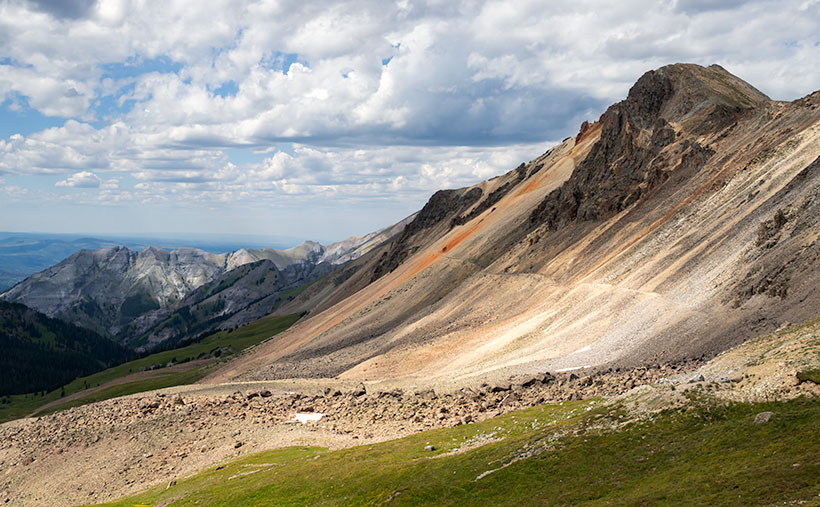
My first Phoenix visit was during the summer of my high school junior year. It wasn’t much of a visit. Dave and Edith—my mom’s niece and her husband lived here. They moved here from Michigan, and he hadn’t been able to find steady work as a mechanic, so my dad offered him a job maintaining his debilitated fleet of Corvair vans. They accepted and immediately packed up to move to the coast. Since I was on summer vacation and my wallet had that new-drivers-license smell, dad volunteered me to drive one of their trucks.

My father put me on an early flight out of the tiny Burbank Airport, and I arrived at an even smaller terminal where Dave met me. Parked at the curb outside was his white El Camino. I don’t remember the year, but it was loaded with toolboxes and the rest of his shop equipment. I didn’t question if it was overloaded because that was above my pay grade and comprehension at the time. I was only impressed that it had a four-on-the-floor, and it made a rumble when he started it.

We drove straight to their home, where a moving van was packed and ready for the trip. The only things that I got to see in Phoenix were the airport, the freeway, his house, and the biggest Goodyear Tire sign in the world. Even Hollywood didn’t have a sign that big and bright. I do remember that it was only mid-morning, and it was already hot. Automotive air conditioning was an exotic thing back then, so we drove with the windows down.

We didn’t spend much time at the house because everything was packed and ready. I was assigned to drive the El Camino, and he would follow in the U-Haul (or whatever brand he had rented). Both vehicles were packed to the gills, but Dave still had loads of unpacked clothes and threw them on my passenger seat before heading west on Highway 60.

Not many cars had air conditioning in 1963, but they all had wind-wings, little adjustable windows at the front of the door windows. They were useful for defogging the windshield, sucking out cigarette smoke, and when driving across the desert, they would divert the scorching wind from your face. By noon we were driving across the open desert west of Wickenburg, and my wind-wings were wide open.

Cars also had temperature gauges then because they frequently overheated. Nothing was broken; they just did that. While you drove, you watched your speed, the gas gauge, and the water temperature. You planned your stops by what the gauges said. As the day grew hotter, and the overloaded little El Camino began to run hot, and I pulled over to let Dave know. We began stopping at gas stations in each of the little towns we passed in an abundance of caution. There we would hose down the truck’s radiator and then continue on our way.

That was until we stopped at a place in the middle of nowhere. As I looked around, all I could see was the barren desert surrounded by dry, jagged mountains. The water spigot had a lock on it and a sign that read, “Water 1.00 a gallon.” That was five times the price of his gas; it was outrageous. The man behind the cash register justified the cost by saying, “Look around you, kid. Do you see any water? I have to pay to have this trucked in.” We gave in and bought a couple of gallons and slowly poured it over the gurgling radiator.

We drove another 200 miles without another incident, all the while the expensive water ate at my brain. Once we reached the cooler air in San Bernardino, the little truck behaved itself. As we drove the two-lane road crossing the lower Mohave Desert, we saw hundreds of freeway miles under construction off to the right. Interstate 10 was finished from L.A. to the Colorado River when I moved to Phoenix a decade later. In Arizona, it stopped at a place they called The Brenda Cutoff. For years I wondered who Brenda was. After moving to Congress, I realized that Brenda was the town where that infamous gas station was, and I finally put two and two together.

New Water Black Mesa - The early morning sun highlights the cliffs of Black Mesa overlooking Interstate 10 in western Arizona.
New Water Black Mesa – The early morning sun highlights Black Mesa’s cliffs overlooking Interstate 10 in western Arizona.

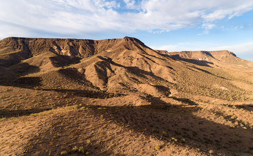
Last Tuesday, I pointed out the old station’s ruins and told Fred this story—well, an abridged version—as we drove back from our photo-shoot. We went there to photograph this week’s featured image of the Black Mesa in the New Water Wilderness Area. The Ramsey Mine Road approaches the wilderness, and it starts in Brenda. The lava-rock covered mesa cliffs are another of my favorite Interstate 10 landmarks. When I see them on the south side, I know that we’re almost to Quartzite, and the Colorado River is soon after. I’ve admired these formations each time I pass under them, and it’s taken me decades to figure out how to get closer. I called this shot New Water Black Mesa because there are dozens of Black Mesas throughout Arizona, so I have to start including which mesa I’m talking about.

You can see a larger version of New Water Black Mesa on its Web Page by clicking here. Next week we start a new monthly project as well as a new year. Queen Anne and I will still need to keep close to home, so come back next week and see what subject we chose.

Until next time — jw

Placerita Post Office Picture of the Week

It was lust for gold that lured men to the Weaver Mountains in southern Yavapai County. They heard stories of miners plucking nuggets from the ground and, in just a day, returning to camp a wealthy man. The fever for gold outweighed the risks of hostile Indians, treacherous mountains, poisonous snakes, and oppressing heat from the relentless sun.

Prospectors discovered several veins of the precious mineral with Rich Hill at their center. Pauline Weaver’s party started the rush when they accidentally found placer gold on the hill’s top. Boomtowns sprung up surrounding Rich Hill. The camps in Stanton, Octave, and Yarnell all had ore-bearing mines. There were so many claims on the hill; it’s a wonder that prospectors didn’t dig into each other’s tunnels. But it only took 20 years for the gold to dry up; as a result, when Anson Wilbur Callen arrived in the 1880s, he decided to prospect somewhere else.

If you flew a small airplane due east of Yarnell, you’d see a geographic anomaly. Instead of the regular distribution of peaks and hills in the Weaver Range, there’s a 2-3 mile gash between Antelope Peak and Rich Hill. From Yarnell, it runs northeast, and it looks like a score on the top of a loaf of bread. It’s very evident on a topo map or Google Maps.

There’s a natural divide in the gap’s center, and Antelope Creek drains south along the east flank of Rich Hill. Arrastre Creek flows in the divide’s north side (Arrastre is the Spanish word for a drag, as used for mining). Anson set up his camp where Arrastre Creek flows out of the canyon.

By accounts, Anson Callen was a big man and weathered beyond his age. Locals called him Old Grizzly at the age of 40. When he set up camp, his initial task was to create a reliable water source, so he dammed up the creek. As he dug a five-mile water ditch to his base, he uncovered two pieces of gold that earned him $550. There are more stories of finding large gold nuggets in the area—one of which was four pounds that the assay office valued at $900 ($107,792 in today’s market). Before Anson knew what had happened, the town of Placerita sprung up around his claim.

On Tuesday morning, I dragged my friend—Fred—out of bed, and at 5 a.m., we drove his Toyota FJ into the sunrise to find the ghost town of Placerita. As I’ve written, real ghost towns rarely have any remaining artifacts. Maybe there’s a pile of timber or a concrete slab, but never an intact building. My research showed that Placerita had a standing stone cabin, and I needed to photograph it.

Ruins in the Woods - From the roadside, we could see the remains of one of the town buildings, but we couldn't see an easy way to get to it.
Ruins in the Woods – From the roadside, we could see the remains of one of the town buildings, but we couldn’t see an easy way to get to it.

When we got to the area, we drove by a shed with a collapsed roof, but the brush was so thick that we couldn’t find a path to it. Instead, Fred drove down to the creek crossing and parked in an apparent campsite. We intended to hike up the creek, find the buildings, and photograph the ruins. Indeed, they were built along the banks. We soon discovered that walking in a dry creek bed wasn’t the best thing a couple of septuagenarians should do—especially a pair that has a hard time walking on carpets. We struggled for what seemed like a couple of miles, occasionally falling on the rocks and swatting at attacking insects.

Placerita Post Office - The 30 townspeople were served by this Post Office from 1896 to 1910, when the gold ran out.
Placerita Post Office – The 30 townspeople were served by this Post Office from 1896 to 1910 when the gold ran out.

Finally, we gave up and started back to the truck, but instead of the creek, we found a cattle track that had boot prints. We followed it to a clearing where—you guessed it—we found the collapsed building. We spent some time shooting photographs from different angles, including this week’s featured image called Placerita Post Office. About half the walls were standing, but the timbers were full of termites, and that finally caused the roof to collapse.

We never found the stone cabin—or at least we thought we hadn’t—but after I got home and did some further research, I found a photo caption that said, “It has been reported that the roof has collapsed since this picture was taken.” We did reach our goal; it’s just ten years too late. I also found out that the stone building that we shot was the town’s Post Office—built in 1896 and closed in 1910. As a federal building, it was built more durable than the rickety shacks that the miners cobbled together. It makes sense that it outlasted the rest of the town.

You can see a larger version of the Placerita Post Office on its Web Page by clicking here. I hope you enjoy it. Come back next week to see the work I’ve shot along the road to Placerita.

Until next time — jw

Lake Como Picture of the Week

Lake Como as seen from the top of Calaifornia Pass.Lake Como – A little alpine lake from California Pass in Colorado’s San Juan Mountains.

Something is intoxicating about standing on a mountaintop. You get a sense of accomplishment—an incredible buzz—while taking in the view. As you spot familiar landmarks, the map you carry around in your mind gets updated. I can understand the addition mountain climbers have to the highest peaks. I’m just too lazy to be one of them, and you won’t catch me on the climbing wall at the local gym—or inside the gym in the first place. Spending a day with Fred driving his FJ up-high passes in the San Juan Mountains was good enough for me.

When we decided not to spend all day driving Colorado’s Alpine Loop but drove up two of its passes, we wanted another challenge. The first ascent was scary, while the second was not so much. I felt like a kid on a swing urging his parents to push harder. “Again,” I shouted. So, we stood on Engineer Pass with the map spread over the hood, looking for another route back to Silverton. After all, we didn’t want to go back down the way we came. That was along the Animas River and was flat and dull. We agreed on a route that would take us over two more passes before dropping back to Silverton via Cement Creek, and that meant that we’d have first to drive back down to Animas Forks.

From the ghost town, we headed west up California Gulch. Going in this direction, the road ran straight ahead for several miles and appeared to end midway up California Mountain. Several times, I’ve traveled roads without a clue what’s ahead. For example, Interstate 15 is heading north out of Mesquite, Nevada. As it leads for the Beaver Mountains, you can’t pick out where the freeway climbs over them. I always involuntarily back out of the gas in case the road suddenly ends—like against the mountainside. At the very last moment, the Virgin River Gorge opens and swallows the highway. I was getting that feeling now.

It wasn’t until the perceived end of the road that it turned on itself and climbed behind a side ridge that hid the route from below, and as we drove around the bend, the trail went vertical. I questioned our decision to go this way because this was undoubtedly the beginning of the roller coaster from hell. Fred managed to keep all four wheels on the ground while his truck grunted its way up the grade. When we reached the top, as with the other passes, there was a spot to park and look around. When I got out, I decided a box of Depends would be a handy accouterment on these trips.

But the view! The light was coming in, and there were great shots back at California Gulch, and in front was this pretty little alpine lake—Lake Como—on the other side. I have seen pictures of places like these in magazines, but I’ve never been to one. It was breathtaking—well, 13,000 feet is stunning enough, but you know what I mean. I snapped several variations of this photo, and we eventually drove down to the lake where Fred tried to park over an open mine shaft, but that’s another story. This week’s featured image is the version I liked best because of its composition and color details. I call it Lake Como. I hope you like it.

Don’t let your eyes miss out—feast them on an even grander version of Lake Como right here (Jim’s Page)! Buckle up because we’re diving back into Colorado’s enigmatic San Juan Mountains aboard Fred’s Toyota next week. Trust me, you won’t want to miss this!

Until next time — jw

Engineer Pass Picture of the Week

When my friend Fred planned our off-road excursions through the San Juan Mountains, his initial itinerary was to complete the Alpine Loop, which includes two passes, circling Red Cloud Peak, Sunshine Peak (which are two of Colorado’s 14,000 foot mountains, but aren’t even in the top 10), and a stop in Lake City. Now that I’ve had time to recover and look at my maps, I think that would be a fabulous trip, especially if we did it later this month when the aspens turn color. But, when we stopped at the Silverton information center, he was told that it’s a seven-hour trip, and it was already afternoon, so we decided to sample some of the passes around Animas Forks instead.

Last week’s image was from Cinnamon Pass, and this week’s picture is from Engineer Pass—our second stop. Both of these places are along the Alpine Loop. If you do Cinnamon first, the route will be counter-clockwise and the opposite direction if you first go over Engineering Pass. The two passes are only miles apart, and most of the Alpine Loop is east of them. Although they’re relatively close, as the crow flies, driving the road requires descending 3,000 feet to the ghost town then 3,000 feet back up the other way. If I thought going up the mountain was exciting, going down was harrowing. I almost got out and walked.

Mountain Man Fred
Mountain Man Fred – It’s not an illusion that Fred’s hanging on to that wire. The sign is well over the slope, and the footing is unsure because of the loose shale.

As we rounded a corner, we saw a knoll where several vehicles were parked, and a crowd snapping selfies and taking in the view. We assumed this was it. It wasn’t. It was Odom Point, and we joined the others for the view and document our visit. As we returned to the road, a sign that said that our pass was further down the road, so we drove another couple hundred yards.

Engineer Pass
Engineer Pass – Looking north from the saddle, you can see two mule trails blazed by prospectors. One leads down into the valley while the other zig-zags up the unnamed peak.

This week’s image that I call Engineer Pass was taken from the 12,800-foot high mountain saddle looking north, and it shows an unnamed peak that’s another hundred feet higher. Also visible are two mule trails, one that descends into the valley and the other that cuts across the talus slope past the red streaks before a switchback as it zig-zags to the summit. I declined to try either of the trails.

While we were taking in the view, I turned around and was stunned to spot over a dozen cyclists peddling up the grade from Palmetto Gulch. No way! We were driving a jeep, and I was out of breath, while these guys were racing mountain bikes on the same road. It’s no wonder that Stephan Pastis ridicules bicyclists in his syndicated cartoon Pearls Before Swine. They’re insane.

You can see a larger version Engineer Pass on its Web Page by clicking here. Be sure to come back next week when we’ll continue exploring Colorado’s San Juan Mountains in Fred’s Toyota.

Until next time — jw