

Picking a new back road to explore, photograph, and talk about is easy for some months. I may have seen a place that piqued my curiosity, and I’m ready to go. Other months are hard. I’ll pour over my maps, hoping to find inspiration. This month was different. When Queen Anne told me that she wanted to visit an ex in Florence (1), I knew right away which trail we’d be talking about in November. Of course, we’d pick the Florence-Kelvin Highway.
The highway between Florence and Kelvin is a 34-mile shortcut between the towns. Although it’s 13 miles shorter, driving around the Tortilla Mountains and through Superior using the paved highways is faster. I’ve partially traveled this road before when I photographed the Cochran site—the ghost town where only the coke ovens remain. They paved sixteen miles of the highway between Florence and the Cochran Road. It’s a long gentle grade rising 1500 feet. Then it winds through the Tortilla Mountains, past a couple of ranches, before descending into Kelvin—a small community along the north bank of the Gila River. Although there may be some wash boarding between gradings, the dirt is broad and doesn’t require a particular vehicle.
On this trip, Anne and I drove east to west, so we’d be somewhat closer to home. From Congress, we drove two and one-half hours to Superior, and most of that time was spent getting to the other side of Phoenix. In Superior, we turned south on County Road 177 to Kelvin—a community so small it doesn’t even have a Dollar Store. Something that Kelvin does have is the Ray open-pit copper mine currently managed by the Mexican mining company, Asarco. And it’s where I photographed this week’s featured image that I call Ray Tailings.
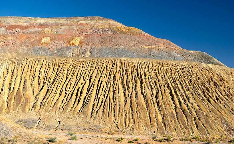
This operation is so massive that you see it on the east side of the highway for a couple of miles. The central pit—Jimmie Luck Gulch—looks like it could be used to mold giant Devo hats (“Whip it good“). In the middle of the Dripping Spring Range, the mineworkers have dug a negative mountain with terraces that the behemoth trucks use to haul ore to the surface. Digging that much dirt out of the ground to remove the copper, you have to stack the sterile waste somewhere, and that’s what I photographed for this week’s issue. It’s the mountain stacked up—inside out. The minerals found beneath the surface colors each layer. To me, the 500-foot pile looks like a gay-pride wedding cake.
It’s an impressive bit of technology to see, but it also causes environmental problems. Because the rocks and dirt are devoid of nutrients, unless scientists intervene, it will take centuries for plants to colonize the tailings. So that makes them susceptible to accelerated erosion. With each heavy rain, bit by bit, the pile makes its way into the Gila River and eventually the Sea of Cortez. That’s not good for the downstream people who rely on the river for clean water (Arizona Copper Co. vs. Gillespie).
You can see a larger version of Ray Tailings on its Web Page by clicking here. I hope you enjoy viewing it. Next week, we’ll continue along the Florence-Kelvin Highway, and I’ll show some of the natural beauty we found there.
Until next time — jw
(1). For those of you that live in another state, or don’t get the joke, Florence is the location of Arizona’s State Prison. She doesn’t really know anyone incarcerated there, but that’s not as funny.