Stoned Bunny Picture of the Week

Stoned Bunny - I admit that it's a stretch to see this rock as a rabbit, but Camelback Mountain's Praying Monk is obscure too.
Stoned Bunny – I admit that it’s a stretch to see this rock as a rabbit, but Camelback Mountain’s Praying Monk is obscure.

I love the park service’s pamphlets at the entrance gates. I collect them. In addition to a map, they show all the things to see and do inside the park. When I opened the one for Chiricahua National Monument and looked at all the trails, I thought it looked like a drunken pirate’s treasure map. There are trails on the straight and narrow; trials that go in circles, ones that climb mountains, while others descend into canyons.

Visitors don’t need to hike any of the trails. There are several parking areas where they can take in spectacular vistas. Heck, you don’t even need to get out of the car. However, if you want a genuine Chiricahua experience, you should venture out and walk among the formations. In the World of Rocks, features are hiding from the parking area. Even after all of my recent bellyaching about hiking, I found a short enough trail for me. It’s called the Grotto Trail, and it was pretty level and less than a mile round trip. I completed my tramp in less than 90 minutes, including my photography stops. Over the balance of this month, I will show you the trail’s highlights.

Do you remember several months ago when I wrote how the pixies build trail markers out of stacked rocks—called cairns? Well, there are no cairns in this monument. Using rock stacks to find your way through a park full of stacked rocks is useless. Cairns would be camouflaged. Instead, the WPA installed signposts at junctions and points along the way. How novel.

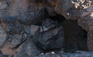
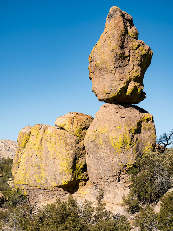
I found the balanced rock featured in this week’s post not far from the trailhead, so I shot it twice, once on the way out and again on my return. Calling the image Balanced Rock seemed dull because there are so many beside the trails. Then I’d have a series of photos named: balanced rock 1, balanced rock 2, etc. So, as I processed them, I tried to imagine what they resembled. If I close my left eye and stare at this image, it looks like a rabbit with his ears up and the face of Mr. Magoo. If I close my right eye, the image resembles a poorly crafted Easter Island statue.

Trying to decide, I stared at my computer and alternating eyelids when Queen Anne walked into the room, slapped me upside the head, and yelled, “Stop doing that. You’ll put your eye out, kid.” I was on the rabbit at the time, so that’s how it got its name—plus, I ate Stoned Rabbit at a fancy Italian restaurant once; it tasted like chicken.

You can see a larger version of Stoned Bunny on its Web Page by clicking here. Next week I’ll show you another shot that I took on the way to the Grotto. Be sure to come back and take part in the fun.

Till Next Time

jw


Lava Grass  Picture of the Week

Christmas, along with the rest of the solstice holidays, is almost over. I hope that Santa brought you something better than the lump of coal I got. Queen Anne is on the couch in her bathrobe and tiara with a box of Kleenex. She’ll be useless until Amazon Prime stops showing Christmas movies. Since we won’t be back before then, we’d like to wish you the best New Year in 2022. Things have got to turn around eventually, so let’s give it a go one more time.

Today, I will finish up the year, and our visit to Snow Canyon State Park by talking about the other rock found there—basalt from recent lava flows. If wind, water, and ice sculpt sandstone, the cooled magma is geology’s Etch-a-Sketch reset button. The black rock covers the softer sandstone and forces water to change course. The runoff carves different canyons, like in the park.

As you explore the park’s north side, you’ll see basalt-covered cliffs. They used to be the canyon floor, but 27,000 years ago, the lava forced the drainage west and carved a new floor—now a couple of hundred feet lower. Snow Canyon has a couple of trails that wander through the jagged black rocks; the Lava Tube and the Cinder Cone trails. The latter is interesting because you can hike to the cone’s rim and look into the extinct caldera. However, the track is uphill, and on the east side of State Route 18, so we skipped it.

Lava Tube - When the magma skin cools and then ruptures, the flowing magma escapes leaving behind a cave.
Lava Tube – When the magma skin cools and then ruptures, the flowing magma escapes leaving behind a cave.

The Lava Tube Trail is shorter,  level, and leads to two lava tubes—which are places where the hardened surface fractures releasing the still molten magma inside to flow away. The remaining caves are sometimes big enough that you can crawl into and see where the bats and spiders live—I’ll pass. The above photo is the smaller tube, and visitors— braver than I—crawl into it.

Lava Grass - A small tuft of grass ekes out a living in barren basalt.
Lava Grass – A small tuft of grass ekes a living in barren basalt.

I find basalt a challenging subject to photograph. It’s like taking a picture of a black cat in a coal mine. To get any detail, you need to over-expose, which washes out the rich depth. Fortunately, and is the case with this week’s picture that I call Lava Grass, there’s enough green lichen growing on the rock to prevent the shadows from completely blocking up.

I feel lucky to have spotted the tuft of dried grass surviving in the barren rock. I concentrated hard on staying upright as I hiked the trail in the early morning. The jagged basalt is not skin-friendly and will likely draw blood if you fall on it. And—silly me—I left my bicycle helmet at home.

You can see a larger version of Lava Grass on its Web Page by clicking here. Next week we start a new year, with a new project in a new location. Be sure to come back and see where the road takes us.

Until next time — jw

Eagle Eye Cliff Picture of the Week

There’s trouble brewing for me. In this case, it’s a good problem—it’s mischief, really. My conflict is a clash between my annual wanderlust and self-preservation. Sitting on each of my shoulders is an angel and a devil (they’re a metaphor, I don’t really see them, so don’t send a paddy wagon after me). The good one tells me to take the long-term view, while its counterpart tempts me with immediate gratification.

Arizona’s winters come in two parts; cold and wet. They’re relative, of course, nothing like what you see in other parts of the country, but hey, it’s what we’re used to. During the cold period, our weather drops in from the Gulf of Alaska. The second half of our winter is wet because the incoming storms originate over the Pacific. In between these mini-seasons, high pressure settles over the State, and we have warm, sunny days and cool evenings. This period of ideal weather can last from one to six weeks. Last year, we skipped the wet part and went straight to summer.

Last week we had a cold front move through our state with high winds and cloudy skies. It left us and went to Texas, and you can see what happened there. But the second half of the week was sunny and clear. The air was so clean; you could make out boulders on distant mountains. I immediately knew that this is our mid-winter lull. I say we should close the Arizona border so outsiders don’t find out why we live here.

Thursday morning, I took my cup of coffee out onto the back of the deck, and I got that familiar feeling in the pit of my stomach. I need to be on a boat somewhere with a fishing line tied to my big toe while I nap in the sun. This is my annual spring wanderlust, and I want to go somewhere—anywhere. I’ve had enough of winter; I’m ready for adventure.

But, we still have this global plague to deal with. Queen Anne and I have received our first vaccine dose, and next week, we get the second. However, that isn’t a Get out of jail free card. We still have to constrain ourselves. I don’t know how much more willpower I have. I’m really ready to flick the angel off my shoulder and drive to the coast to taste the new wines, visit some Santa Fe galleries, or explore Utah’s Henry Mountains, anyplace but Aguila.

Eagle Eye Cliff - The cliffs on the south side of the Eagle Eye Mountains shows that there is limestone foundations under the lava.
Eagle Eye Cliff – The cliffs on the south side of the Eagle Eye Mountains show limestone foundations under the lava.

But since we’re still stuck in Aguila, let me show you this week’s featured image. I call this one Eagle Eye Cliff. It’s from the same pair of mountains as we’ve explored for the last couple of weeks. The two peaks are the eastern end of the Harquahala Range and are dwarfed by their big brother next door.

I’ve already talked about how the Eagle Eyes are covered in lava, but you can see a limestone foundation underneath in this shot. I don’t know if the white cliff is the remnant of an old reef or the volcanic stone shielded it from erosion. To me, it looks like sloppily done chocolate icing on a white cake. That’s barbaric. Everybody knows that white cake should have caramelized pineapple on it.

You can see a larger version of Eagle Eye Cliff on its Web Page by clicking here. Be sure to come back next week, and I’ll show you the final shot that I liked from my outing in Aguila.

Until next time — jw

What Happened to You Picture of the Week

Arizona has a reputation for being hot—deservedly so. Especially here in the Sonoran Desert. We frequently make the weather news for hosting the highest temperature of the day—a contest in which Gila Bend and Bullhead City are always locked in battle. For some people, any press is good press.

But as I explore the back roads of our state, I’ve come to the conclusion that the heat here had to be way worse many millennia ago. I came to this conclusion because you can’t walk more than ten steps before you step in a puddle of cooled lava—basalt (cooled quickly on the surface), andesite (mixed cooling), and granite (cooled slowly beneath the surface). Not all of this volcanic activity happened at the same time of, course. Millions of years separated eras of activity. What I’m saying is that, at times, Arizona’s ground heat far exceeded our summer temperatures. It’s probably a good thing that we’re living in this era.

The reason I’m hopped-up on geology this morning is because of the next stop that Queen Anne and I made on our one lap of Harquahala Mountain trip. Near where the Eagle Eye Road intersects with the Salome Highway, a series of volcanic hills line the south side of the road. After getting out and clambering all over them, I decided that they didn’t have star power. They’re interesting, but not that interesting. During my investigation, however, I found this poor little weird saguaro. It had eight new arms growing around it’s lopped off the top—sort of like last month’s headless version. As I got closer, I saw that the new arms were growing from other truncated arms—at least a dozen of them. It was—much like a cat eats grass to settle its stomach—like a T-Rex chomped off its top, so the saguaro put out new shoots. I remember thinking, “What the hell happened to you?” Was this caused by freezing, disease, or repeated lightning strikes? I don’t know, I’ve never seen a saguaro like this.

What Happened to You-a poor little saguaro has arms growing out of damaged arms. What caused this to happen?
What Happened to You -A poor little saguaro has arms growing out of damaged arms. What caused this to happen?

I decided to capture its portrait, and, as I framed it, the hills came in play. I lined up my shot so that the sunlit saguaro was centered on the dark rocks on the outcrop. I was so impressed with how clever I was, I also shot a dead tree and palo verde in the same way, but they didn’t come out as well. I titled this shot What Happened to You, and it’s this week’s featured image.

You can see a larger version of What Happened to You on its Web Page by clicking here. I hope you enjoy viewing it. Join us next week as we finish up our trip around the Harquahala Mountains.

Until next time — jw

BTW: Queen Anne and I wish you and your loved ones Bah Humbug—and similar salutations of the season.