Limestone Hoodoo Picture of the Week

When opportunity knocks, why not answer the door? I got this week’s picture that way—and last month’s grazing horses to boot. Here’s what I mean.

I had driven up to Skull Valley, intending only to get a shot of the red train station at sunrise, but after I got what I wanted, it was still early, and the light was wonderful. I decided to hang around and shoot the town’s other buildings. Since they’re all next to each other, I was finished, and I packed the truck by 6 am. The Ranch House wouldn’t be open yet, so I had time to kill.

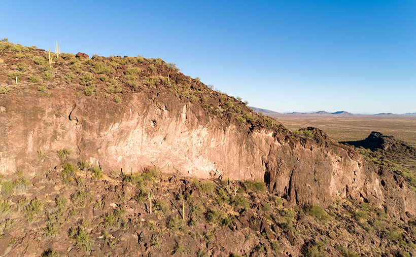
About 3 or 5 miles south of Skull Valley—where the highway drops into Skull Valley Wash—there is an area of limestone deposits. I wrote about this place in my Kirkland Peak post and explained that you could see some interesting formations along the road. Because they were on private property, I’d been frustrated photographing them. On top of that, a new mine is moving in, and I’m afraid that they’ll flatten everything soon.

Limestone Hoodoo - Along the roadside south of Skull Valley is a deposit of limestone and interesting hoodoo formations.
Limestone Hoodoo – Along the roadside south of Skull Valley is a limestone deposit and interesting hoodoo formations.

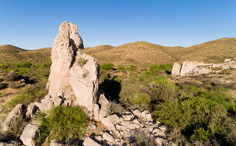
When I got to the hoodoos, it was still too early for the workers to be on shift, so I stopped at the north hoodoo to take this week’s photo. I call it Limestone Hoodoo. When I composed this image, I wanted to get the white rocks in their natural setting, and that’s why I included the outcrop on the right side. There’s a larger expanse of the limestone behind me—on the other side of the road—but so is a church and the mine.

Now for something completely different.

If you don’t mind, I’d like to digress and talk about something else. In June, I presented two styles of photography that I shoot, landscape and architecture. I would have preferred the month have consistent subjects, but there were only three buildings in town. So, I finished up this week with a nearby landscape, and the photo happened to tie up a loose end.

As you probably guessed, the biggest influence in my photography is Ansel Adams—and I’m only one of his numerous disciples. But—as I said at the month’s beginning—I also find historic things compelling, so I also shoot them as I trip over them. When I was a student at Phoenix College, I had a professor that said my buildings reminded her of the French photographer Eugène Atget. At the time, I didn’t know who that was, so I researched his work and concluded that she gave me a helluva compliment. I know that I’ll never fill either of those master’s shoes, but I still have fun following their footsteps.

The point that I’m trying to get to is how do you—my audience—feel about these subjects? Do you like one better than the other? Do you like the occasional variety, or do you get turned off when the subjects change? I’m very interested in your opinion, so please feel free to share them in the comments below.

You can see a larger version of Limestone Hoodoo on its Web Page by clicking here. Next week, I’ll have something from the other side of Congress, so be sure to come back for that.

Until next time — jw

Eagle Eye Cliff Picture of the Week

There’s trouble brewing for me. In this case, it’s a good problem—it’s mischief, really. My conflict is a clash between my annual wanderlust and self-preservation. Sitting on each of my shoulders is an angel and a devil (they’re a metaphor, I don’t really see them, so don’t send a paddy wagon after me). The good one tells me to take the long-term view, while its counterpart tempts me with immediate gratification.

Arizona’s winters come in two parts; cold and wet. They’re relative, of course, nothing like what you see in other parts of the country, but hey, it’s what we’re used to. During the cold period, our weather drops in from the Gulf of Alaska. The second half of our winter is wet because the incoming storms originate over the Pacific. In between these mini-seasons, high pressure settles over the State, and we have warm, sunny days and cool evenings. This period of ideal weather can last from one to six weeks. Last year, we skipped the wet part and went straight to summer.

Last week we had a cold front move through our state with high winds and cloudy skies. It left us and went to Texas, and you can see what happened there. But the second half of the week was sunny and clear. The air was so clean; you could make out boulders on distant mountains. I immediately knew that this is our mid-winter lull. I say we should close the Arizona border so outsiders don’t find out why we live here.

Thursday morning, I took my cup of coffee out onto the back of the deck, and I got that familiar feeling in the pit of my stomach. I need to be on a boat somewhere with a fishing line tied to my big toe while I nap in the sun. This is my annual spring wanderlust, and I want to go somewhere—anywhere. I’ve had enough of winter; I’m ready for adventure.

But, we still have this global plague to deal with. Queen Anne and I have received our first vaccine dose, and next week, we get the second. However, that isn’t a Get out of jail free card. We still have to constrain ourselves. I don’t know how much more willpower I have. I’m really ready to flick the angel off my shoulder and drive to the coast to taste the new wines, visit some Santa Fe galleries, or explore Utah’s Henry Mountains, anyplace but Aguila.

Eagle Eye Cliff - The cliffs on the south side of the Eagle Eye Mountains shows that there is limestone foundations under the lava.
Eagle Eye Cliff – The cliffs on the south side of the Eagle Eye Mountains show limestone foundations under the lava.

But since we’re still stuck in Aguila, let me show you this week’s featured image. I call this one Eagle Eye Cliff. It’s from the same pair of mountains as we’ve explored for the last couple of weeks. The two peaks are the eastern end of the Harquahala Range and are dwarfed by their big brother next door.

I’ve already talked about how the Eagle Eyes are covered in lava, but you can see a limestone foundation underneath in this shot. I don’t know if the white cliff is the remnant of an old reef or the volcanic stone shielded it from erosion. To me, it looks like sloppily done chocolate icing on a white cake. That’s barbaric. Everybody knows that white cake should have caramelized pineapple on it.

You can see a larger version of Eagle Eye Cliff on its Web Page by clicking here. Be sure to come back next week, and I’ll show you the final shot that I liked from my outing in Aguila.

Until next time — jw

Verde Limestone Picture of the Week

For centuries the Verde River Valley has been a peaceful home for many peoples. It makes sense because the Verde River flows year-round, even in times of drought—as we have now. The green waters of the Verde—Spanish for green—flow between the Black Hills (Mingus Mountain) on its south-west flank and the Mogollon Rim to the north-east. The river runs from Chino Valley to Fountain Hills—170 miles. It collects the runoff water from the rim via its tributaries like Sycamore Creek, Oak Creek, Beaver Creek, and West Clear Creek. Although the river bottom is a dense cottonwood forest, its flood plains are perfect for growing corn and squash.

There are many sites of early inhabitants along its length, but the best known is the pueblo of Tuzigoot—built by the Sinagua people in the 10th century. They only lived there for a couple of centuries before moving on. The next settlers to arrive were Apaches—Canadian migrants that were chased off the plains by the Sioux. The various bands of Apache established homes along the transition zones across Arizona and New Mexico. They weren’t aware that their new landlords were the Spanish, who were mostly interested in saving their souls and stealing their gold. For the next 300 years, life in the Verde River Valley was peaceful.

Then one day, in 1821, there was a knock on the door—er, teepee flap. It was a government man. He was there to inform one and all that they were Mexican citizens now and, by the way, do you have money to chip in for our new country?

After that, things began to happen fast, and life seemed to go downhill quickly. A mere 30 years went by when another man rode up on a horse, shook a bunch of hands, handed out flyers, and declared, “Welcome to America.” The very next year, Californians discovered gold, and easterners clogged up the trails rushing to get to it. Some got rich, but most of them didn’t get to the Golden State in time, so they made their way back and decided that our valley would be an excellent spot for a farm. There was a civil war going on back home anyway, so they moved into the neighborhood. The Apache’s homeland began to shrink.

In 1864, the Americans stuck a flag in the ground and called it Fort Whipple—the Arizona Territorial capital. The next year they moved the flag from Chino Valley to a mining camp on Granite Creek. The Army stationed cavalry troops to protect the miners, and that later became the town of Prescott.

Life was tense, but there was an uneasy truce between the tribes and the new settlers until those mangy miners started working the Verde Valley. They picked at the rocks, piled dirt everywhere, muddied the water, ate all the food, and drank all the whiskey. It was the straw that broke the Gila monster’s back, and the Apache tribes declared war—Yavapai War (1871-1875). That’s the precursor of General George Crook’s assignment to Fort Whipple and his trail to Fort Apache that we began exploring last week.

Verde Limestone - A limestone ledge in the Verde River Valley in the lovely light of the evening sun.
Verde Limestone – A limestone ledge in the Verde River Valley shines in the lovely light of the evening sun.

This week, we traveled east along the Verde River for a few miles and stopped near Dry Beaver Creek to photograph a limestone formation. They’re found throughout the valley and are most evident on the river’s north side. As you travel Interstate 17 towards Flagstaff, it’s the white layer between the Verde River and Sedona. Limestone forms in shallow seas from dead shells and bones. It’s a great place to look for fossils, and coincidently one of our planned stops was to be Fossil Creek, but it was closed due to COVID 19.

This week’s featured image—called Verde Limestone—shows a ledge exposed by years of erosion. For balance, I included the lower mound of the same compound shining in the lovely evening sunlight.

You can see a larger version of Verde Limestone on its Web Page by clicking here. Be sure to come back next week as we climb out of the Verde Valley and see what we found along the General Crook Trail.

Until next time — jw