Erosion and Elevation: Arizona’s Basalt Playground Picture of the Week - Wikieup, Arizona

A sun-kissed Arizona landscape showcasing erosion patterns on basalt rock formations, a tear in the earth, and desert flora like Palo Verde and Saguaro.
Erosion and Elevation: Arizona’s Basalt Playground – This striking photograph captures the complex topography along Arizona’s US 93. Late afternoon light bathes a basalt outcrop and highlights the intricate erosion patterns, casting dramatic shadows across the earth. A tear-like ravine carves through the landscape, bordered by softly rolling hills and rugged cliffs. The terrain is dotted with native flora, such as Palo Verde trees and Saguaro cacti. Above this awe-inspiring scene, cumulus clouds meander across the sky, echoing the earth’s undulating forms.

Well, folks, it’s week two of our September golden hour stint along good ol’ US 93. Last week, we dabbled in the architectural nuances of silt cliffs—kind of like the Las Vegas Strip but without the neon lights or questionable life choices. Today, we clambered back into the truck, waved hasta la vista to the Big Sandy River, and headed south like snowbirds in reverse. After scaling what can only be described as a geographical hiccup of a hill, we’re greeted by the brooding spectacle of a lava dome. Not the explosive kind, mind you. This one’s been dormant long enough to warrant a picture.

This is one of those places that has escaped my camera for decades because I had been rushing to somewhere else, the light wasn’t right, or the ‘T’ on my typewriter sticks. Pick any excuse; it doesn’t matter. The truth is that I never made myself stop until this afternoon’s trip.

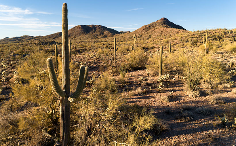
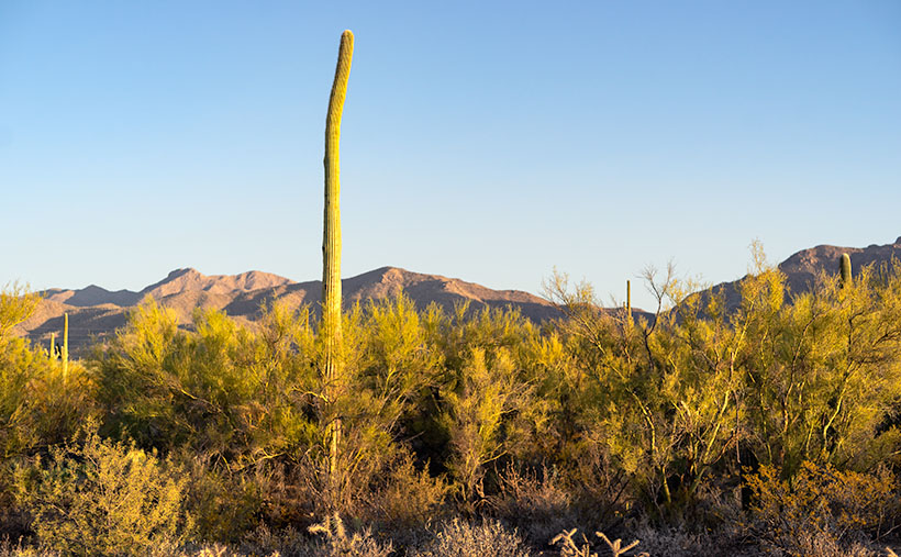
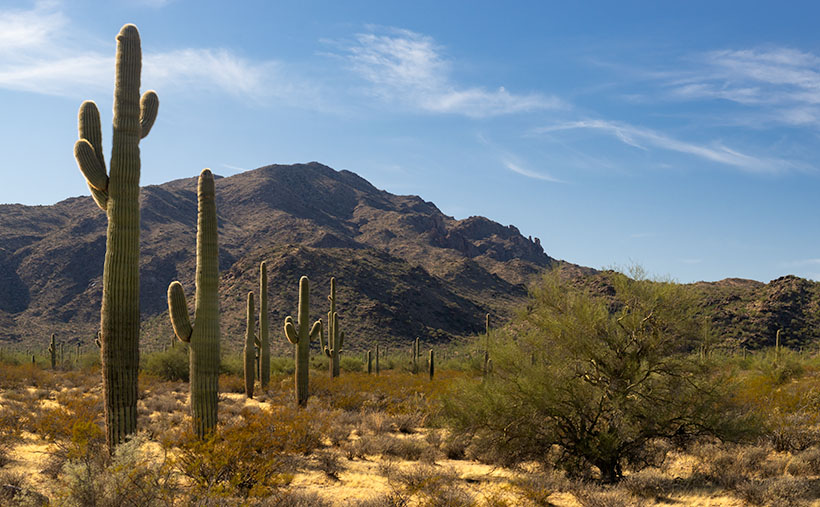
Have you ever driven on US 95 toward Goldfield, Nevada, and thought, “Gee, what this place needs is more cactus”? Well, welcome to Arizona’s answer. Trading Nevada’s coarse, scratchy sagebrush for a verdant army of Palo Verde and Saguaro cacti is far from the barrenness one might expect—like trading in a Ford Pinto for a Mustang.

Don’t be fooled by the lush desert life clinging to these hills. Forget garden-variety potting soil; what you’re laying eyes on is rugged, unyielding basalt—nature’s bedrock. Yep, volcanic rock is hard enough to make diamonds jealous. Another meandering mile down the asphalt ribbon, and we’ll find ourselves hovering on a bridge over a canyon so deep, it could swallow a 30-story building, where Burro Creek has sliced the basalt like it’s a hot knife through…well, rock. Nature’s got its own set of carving tools. It’s such a pretty place that you may want to spend a night in the campground at the bottom, where the song of the semis pounding on the bridge’s expansion joints will lull you into a deep sleep—or give you a headache.

Today’s photography menu featured a main course of Golden Hour light, served up like liquid gold spilling across the jagged landscape, and boy, did it deliver. This week’s photo offers a unique lens into Arizona’s oversized playground. You look at the flora covering these slopes and think, “Ah, a lush, manicured lawn.” But no, that’s not grass. It’s full-sized saguaro and palo verde trees, so don’t go planning a picnic.

What’s more, the distribution of the saguaro says a lot. They’re abundant on this ravine side but scarce on the far side. This is where an imaginary frost line is. That’s Mother Nature’s version of police tape preventing the saguaros from marching north and overrunning Reno. This line in the sand is the boundary between the Sonoran and Great Basin deserts.

Alright, time to hightail it back to the trusty truck; ominous storm clouds are massing in the southern sky, ready to let loose with a downpour. Before you know it, we’ll navigate a basalt slip ‘n slide. Please take a moment to check out larger versions of this week’s photo—Erosion and Elevation—on my website (Jim’s Site) and Fine Art America (FAA Page). Be sure to tune in next week; who knows what wonders—or calamities—we’ll encounter next.

Till next time
jw

Techniques: The Rule of Thirds and the Quest for Visual Balance

The Rule of Thirds is a fundamental principle in photography and art, but its origins are a bit murky. Some trace it back to John Thomas Smith’s 1797 book “Remarks on Rural Scenery,” while others connect it to broader theories of divine proportions. Regardless of its origins, the idea is simple: divide your frame into a 3×3 grid and position the subject or critical elements along those lines or at their intersections. Doing so generally leads to more dynamic, balanced compositions that are more engaging to the viewer.

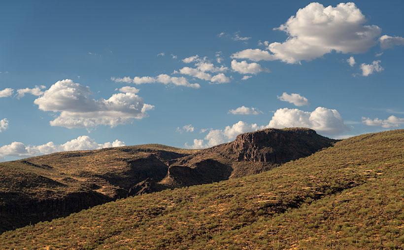
In this week’s photograph, the basalt butte is a textbook example of the Rule of Thirds in action. It straddles the right vertical line, grounding the image, while its peak touches the lower horizontal line. This positioning does more than “look good”—it directs the viewer’s eyes around the frame in a natural progression, from the butte upward to the cloud lines.

Moreover, using the Rule of Thirds for the butte leaves space for the towering clouds overhead, which adds drama and scale to the photograph. This mirrors the real-life experience of being dwarfed by nature’s grandiosity. It also serves a practical purpose—making room for those clouds allows them to act as another compositional element, filling the frame without crowding it.

The Rule of Thirds isn’t an ironclad law—sometimes breaking it produces strikingly original work—but it’s useful for photographers looking to up their compositional game. Understanding and utilizing the Rule of Thirds can transform a ‘pretty view’ into a compelling visual narrative for a landscape photographer like myself.

Blue Tank Saguaro Picture of the Week

It’s only the third month of 2021, and already I can tell it’s a much better year than the last one. If you remember, this time a year ago, I was comforting my dear wife, who was convalescing from knee surgery, we had growing concerns about a new virus that threatened our existence, and we faced travel restrictions to slow its spread. In contrast, this week, I feel like a kid at the end of a time-out, no longer grounded or released from juvy (of course, I was such an exemplary child that I never experienced any of those feelings—my parents just spanked us).

I have this exhilaration of freedom because we got our second vaccination shot this week—and we have passports to prove it. If you’re debating on getting your shots, you shouldn’t be. Queen Anne and I didn’t experience any abnormal side effects. Like any flu shot, your arm is sore for a couple of days, but other than that, our lives went on normally. And as an extra benefit—like a putty knife—the Microsoft chip they snuck into the vaccine scrapes off any plaque in your arteries (but I do have an incredible desire to buy a new version of Windows).

We’re still cautious about our movements—we wear masks and keep our distance, but now we can plan to go on vacation later this summer. In our laundry room, I have a huge wall map of the Colorado Plateau. Whenever Anne gets out of bed this afternoon, I’m going to have her toss a spit-ball at it. Wherever it lands is the place we’ll drag our trailer—The Ritz—this August.

Blue Tank Saguaro - A mature saguaro growing along the bank of the Blue Tank Wash near Wickenburg, Arizona.
Blue Tank Saguaro – A mature saguaro growing along the Blue Tank Wash bank near Wickenburg, Arizona.

I’m so giddy this morning; I almost forgot this week’s new picture. If it looks familiar, it should. That’s because it’s a variation of last week’s featured image. They both show the mountains on the Hassayampa River’s far side, and they both feature saguaro cactus. The difference is that last week’s photo was of the mountains with cactus in the foreground, and this one is a saguaro with the mountains in the background. Who said you couldn’t get two good variations of the same scene by working-the-shot? I called this shot Blue Tank Saguaro for obvious reasons.

I’m interested in hearing what you think. Both images can be seen on their Web Pages, and you can flip between them using the Previous/Next links. You can get to this week’s image by clicking here. Which of the two do you like better? Let me know by leaving your comment at the bottom of this page. Be sure to come back next week for another of my images from the mountains surrounding Wickenburg.

Until next time — jw

UPDATE 4:30 pm: Anne got up and threw her spit-ball at the map, so I guess in August we’re going to . . . the laundry room.

Get Bent Picture of the Week

Not all saguaros are super-models. Like people, they come with all sorts of warts and scars. The Gila woodpeckers carve nests in them because inside the flesh, the summer daytime temperatures can be over thirty degrees cooler than outside. The cavities don’t cause harm to the saguaro, and squatters like hawks, owls, and other birds move in after the woodpeckers leave. The substantial threats to a saguaro’s life are from lightning, strong winds, stupid people, but the real culprit is frost.

On our imaginary day-trip around Saguaro National Park, we’ve left behind the visitor center, and we’re exploring the Bajada Wash Loop, which leads from the west side up toward the Tucson Mountains—the park’s backbone. In fact, these are the only roads into the interior. Countless trails crisscross the park, and they appear to be the preferred method of exploring the backcountry. I’ll leave that mode of transportation to people younger and more agile than me.

Get Bent - A frost damaged saguaro rises above a thicket of palo verde before the Tucson Mountains.
Get Bent – A frost-damaged saguaro rises above a thicket of palo verde before the Tucson Mountains.

The afternoon was getting late when we reach the top of the loop. The shadows were already long as I looked for a shot of the range’s high peaks. I stopped the truck when I spotted an interesting cactus. It rose maybe thirty-feet above the top of a palo verde thicket, and it had a bent trunk. I guessed the deformity was the result of a freeze. It’s a young specimen—if you can consider thirty-years young—to have damage like this, but the Tucson Basin is a thousand-feet higher than Phoenix, and we were near the top of the loop, which is 500-600 feet above the city. That’s near the limits of the saguaro’s range because winter nights often get below freezing up here.

After I processed this shot and began pouring over area maps,  I realized that I also captured another landmark in it—actually two of them. To the saguaro’s left are two peaks on the horizon. The taller of them is Wasson Peak (4639′), and the other is Amole Peak (4386′). They are the two highest points within the park’s boundaries. So, this week you get a BOGO.

You can see a larger version of Get Bent on its Web Page by clicking here. Next week, our day in Saguaro National Park comes to an end, so be sure to come back and see what we found.

BTW: Queen Anne and I wish you a very safe and happy Thanksgiving. We’ll be spending the day at home enjoying store-bought leftovers. You know, the usual turkey, stuffing, mashed potatoes swimming in gravy, cranberry sauce molded in the shape of a can, and buttermilk pie topped with fruit and whipped cream. I’ll see you next week if I can get up from the couch.

Until next time — jw

Saguaro at Harquahala Mountain Picture of the Week

I was researching today’s post, and I found some interesting statistics—at least they are for me—and on an online forum thread that made me smile. In case you hadn’t noticed, I like mountains. I like them big or small, a long chain of peaks or lonesome butte, snow-covered volcanoes or desert ranges. I like them because they’re not flat and they’re visually stimulating. You can gauge travel distances with them. I’d be a terrible mariner out on the sea without landmarks. When I travel through Kansas, I have to replace peaks with grain silos.

I want to learn more about what I see and photograph. I want to know the peak names, their heights, their make up, and how they formed. Most of my curiosity is satisfied with topographic maps, but the geology stuff is gobbledygook.  I wish there were an easy decoder book written for simpletons like me.

The Harquahala Mountains—the subject of this month’s images—are a substantial range, one of the highest in Arizona’s southwest quadrant. I can see its distinctive round shape from my back porch. I started tagging my films with the name Harquahala Studios because it’s fun to say: HARK—qua-hala. Last week I learned that the name in the Mohave language means “water, up high” presumably from the springs on its slopes—a handy fact to know if you live in the desert.

I Googled “Arizona Mountains” this morning and found it listed in the 5,000-6,000 foot elevation group. To find the exact answer that I wanted would have required more research, spreadsheets, and an effort that cut into my nap, so I gave up. But I saw another question in the list that piqued my curiosity. “Which state is most mountainous?” What’s your guess? Set aside Alaska because they don’t play fair. Is it Colorado, California, or Montana? In the discussion, some people were arguing that it’s West Virginia, which is in the Appalachians, and the highest peak is under 5,000 feet—hardly a mountain. They explained that the little state has the lowest percentage of flat-land, so it’s all mountains, therefore the most mountainous.

The answer wasn’t Colorado; California has 500 more named peaks, and Montana is two-thirds prairie that the locals call West Dakota. The response surprised me, but since I read it on the internet, it must be true. Being entirely comprised of the Great Basin Desert with north-south running ranges, Nevada has the most named peaks in the lower forty-eight. They’re not the highest, but there’s a gob of them.

Saguaro at Harquahala Mountains-A line of saguaro looking like telephone poles lead your eye to the massive mountain south of Aguila, Arizona.

This week’s featured image is called Saguaros at Harquahala Mountain, and I shot it south of Aguila, a few miles south of the Eagle Eye Peaks in last week’s post. What made me stop to take this image was the line of saguaros that looked like a row of telephone poles. They create what’s called a leading-line—a perspective tool that brings your eye into the massive mountain. The clouds and the small Palo Verde tree work to keep your attention in the picture’s center—if it works right, your eye moves in a clockwise circle.

You can see a larger version of Saguaro at Harquahala Mountain on its Web Page by clicking here. I hope you enjoy viewing it. Join us next week as we continue our lap around the Harquahala Mountains, and remind me to stay out of the flooded washes.

Until next time — jw