Twilight’s Ember: The Last Rays on Valley of Fire’s Red Rocks Picture of the Week - Valley of Fire State Park, Nevada

A towering red sandstone formation illuminated by the golden light of the sun, set against the clear blue sky in Valley of Fire State Park, Nevada.
Twilight’s Ember – A Natural Sculpture Carved by Time – Witness the interplay of light and shadow on the ancient red sandstone, highlighting the peak as if it were aflame in the heart of Valley of Fire State Park.

Last week, I shared a whimsical thought sparked by our visit to the once-submerged town of St. Thomas along Lake Meade’s shores. The idea? A short video starring our unwitting adventurers in an underwater exploration gone awry. With anything SCUBA, my thoughts invariably turn to the Poteets—Fred being a certified diving instructor. My idea instantly became a classic case of good and bad news. Deb quickly noted the absence of wetsuits in their wardrobe, while Fred, ever the sport, proposed renting them for our aquatic escapade. Thus, I spent the week crafting an epic screenplay for our faux underwater archaeology saga, ready for your enjoyment.


Not Quite a Fathom by Jim Witkowski

EXTERIOR SCENE. ZODIAC DIVING BOAT—DAY

The scene opens with FRED and DEB POTEET, waist up, sitting on the edge of a Zodiac diving boat. Clad in wetsuits, they finalize their snorkeling gear setup. Fred delivers the pre-dive briefing with a hint of solemnity.

FRED
(fiddling with a weight belt)
Remember, St. Thomas has been a memory under Lake Mead’s waters since 1938, untouched by time. The condition of the buildings is unknown, so let’s avoid the timbers.

The camera cuts to a tight shot of Deb; her concern is visible even behind the mask.

DEB
I hope we don’t stumble upon any forgotten skeletons.

Cutting back to Fred, his assurance is firm.

FRED
Fear not. Hugh Lord, the town’s final farewell, waved as the waters embraced his home in ’38. All were safe.

With a final gear check, Fred signals readiness.

FRED (continues)
Ready?

Both poised on the Zodiac’s brink, a countdown commences.

FRED
On three. One… two… three…

On three, Fred leans back and rolls off the Zodiac into the water, followed immediately by Deb.

Cut to a drone camera, tight on Fred’s shocked face.

As Deb turns to Fred, her expression seems to ask, “WTF?” The drone camera slowly pulls up, revealing they are lying face-up on the dry lakebed, their legs still resting on the side of the Zodiac.

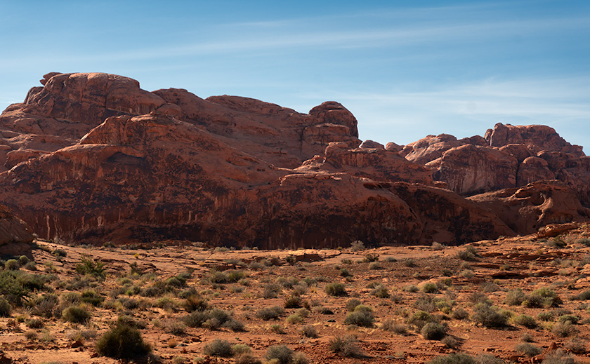
The drone camera pulls back further, exposing the dry town site’s barren concrete foundations and pads. As it gets altitude, Fred and Deb stand up, now tiny figures in the vast, dry landscape, including the Muddy River bed.

The camera ascends, eventually dissolving into a Google Earth Studio shot of the Lake Mead Overton arm, zooming out until the entire planet fills the frame.

FADE TO BLACK.


It’s a masterpiece if I do say so myself. Now, about those props—does anyone have a Zodiac lying around? Or perhaps other treasures hidden in your garage that could bring our production to life? Share your ideas in the comments! But let’s pivot from our playful banter to the awe-inspiring beauty captured in this week’s photographs.

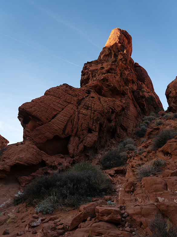
This week’s highlight is a breathtaking sandstone formation, its pinnacle bathed in the sunset’s final embrace. The iron oxide-rich layers glow, a fiery testament to Valley of Fire’s geological wonders.

The uplift and erosion revealing such splendor speak to the Basin and Range Province’s dynamic history. Here, the forces of nature sculpt masterpieces: holes carved by chemical reactions with rainwater, alcoves shaped by the relentless wind, and striations etched by the journey of rainwater.

Thank you for joining us on this adventure. As the Superbowl looms, I wish your team luck and, perhaps more importantly, that this year’s commercials bring us joy. Next week promises more marvels from Valley of Fire. Don’t miss it.

Till then, keep your camera at the ready and your humor dry.
jw

A towering formation of layered Navajo sandstone, named 'whiteGibraltar', stands under a clear blue sky in Valley of Fire State Park, Nevada.
White Gibraltar – The Navajo Sandstone Giant of Valley of Fire – A Vision in Sandstone – Rising from the Valley of Fire’s rugged landscape, this pale monolith echoes the grandeur of its namesake, standing as a silent sentinel in the desert sun.

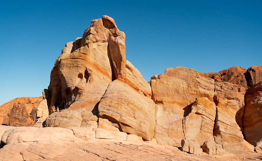
Techniques: Exposing for the Highlight

I spotted the Aztec Sandstone formation while returning to the Turd on a trail hike at the end of the day. My eye was drawn to the very tip of the pinnacle, still glowing in the sun like the flame on the Statue of Liberty or ET’s finger. I knew that if I exposed the shady part of the sandstone, the finger would wash out the nice red color. So, to retain that glow, I pointed my camera at the sky above the finger, half-pressed the shutter to freeze the exposure reading, and slowly lowered the camera to include the rest of the scene.

The raw image looked too dark, and I almost rejected it. However, in post-processing, I could mask off the bright areas and increase the shadows by almost two F-stops. That was enough to bring out the erosion holes and keep the glow on ET’s finger.

Nature’s Palette: Exploring the Red Sandstone Masterpiece at Valley of Fire Picture of the Week - Valley of Fire State Park, Nevada

Red sandstone formations at Valley of Fire State Park, symbolizing the beauty of geologic processes over millennia.
Red Dune Wall in Valley of Fire—A Study in Erosion and Time – The ‘Red Dune Wall’ is a testament to nature’s artistic hand, sculpting the Valley of Fire State Park landscape through the relentless forces of wind and water.

Greetings from the Nevada desert, where Queen Anne (aka Lefty) and I embarked on a wild escapade, armed with nothing but our cameras and a sense of adventure that’s as robust as my morning coffee—deceptively strong and slightly bitter.

It all began in a Mexican restaurant in November, where we had planned to wrestle with the wilds of Gold Butte National Monument. But as we surveyed our gear, we realized we were about as prepared as a fish on a bicycle. With a sigh that echoed off the terracotta walls, we decided to pivot faster than a gambler on a losing streak.

So there we were, poring over maps and munching on nachos when the Valley of Fire State Park flickered onto our radar like a beacon of salvation—or at least a beacon of cell service and paved roads. It was a unanimous decision, fueled by the promise of not getting stuck and the allure of a good story to tell.

After a hearty debate over hash browns and highway maps at Peggy Sue’s Diner the following day, we plotted a less ‘Oregon Trail’ course and more ‘Sunday drive.’ We planned to loop through Overton, graze the shores of Lake Mead, and enter the Valley of Fire from the east, with a sunset deadline to beat the buffet back in Mesquite.

On a whim, we decided to pay our respects to the submerged ghost town of St. Thomas, which was now high and dry thanks to the ever-thirsty sun. The remains were intriguing, but we passed on the hike, preferring to keep our boots dust-free. Instead, I hatched a master plan to lure our friends—the Poteets—into a Jacques Cousteau-style watery charade involving wetsuits and mock-panicked flailing for a film I’d tentatively titled The Great St. Thomas Aquatic Caper.

A towering rock formation known as Silica Dome against the clear blue sky in Valley of Fire State Park.
Silica Dome—The Sentinel of Valley of Fire’s Rocky Landscape – Experience the ‘Silica Dome’ grandeur at Valley of Fire State Park through this captivating image, highlighting the intricate layers and history etched in stone.

As the day wore on, we wandered among the storied stones of the early Jurassic Era. Like Whitney Pocket, these rocks were part of a grander narrative, a to-be-continued tale of petrified dunes stretching from Zion to the Grand Staircase and beyond. The Valley of Fire’s chapters were penned in red Aztec sandstone hues and crowned with white Navajo crests, a chronicle of time written in Earth’s hand.

This week’s photographic heroes are a testament to this fiery anthology. The main photo—a regal formation of red Entrada sandstone—is the park’s namesake, standing proudly amidst the Mojave’s scrappy flora. The supporting act, Silica Dome, wears a coat of Navajo Sandstone, pale and majestic against the desert sky. Together, they tell a story of a sea that once was and dunes that danced in the wind before time turned them to stone.
So, dear readers, come for the photos, stay for the tales, and return next week for another chapter in our desert saga. Will the Poteets make a splash in their wetsuits? Will Queen Anne ever forgive me for the early morning escapades? Find out in the next installment of our arid adventures.

Until then, keep your lenses clean and your humor dry.
jw

Techniques Unveiled: A Tale of Two Sandstones

In the photographer’s toolbox, contrast isn’t just about light and shadow—it’s the story of elements, epochs, and the Earth’s grand design. This week, I set out to capture a tale of two sandstones, a narrative etched into the very landscape of Valley of Fire State Park.

Our lead image, Nature’s Palette, is a canvas painted with iron-rich sandstone, a souvenir from the mid-Jurassic era. Here, the dunes are frozen in an eternal dance, caught mid-twirl by the relentless grip of pressure and heat, akin to the timeless beauty of Canyon de Chelly and the famed arches of Moab. Look closely, and you’ll see the canvas of the ancients—the water-stained varnish that once served as a blackboard for the Fremont and early Pueblo people to etch their indelible art.

The supporting act, Silica Dome, steps onto the stage from a later act in Earth’s drama under the watchful gaze of T-Rex and company. It’s a piece of the past where the climate was as dry as a prohibition-era bar, and vast sandy beaches fringed an ancient inland sea. In this shot, we confront a dune face-to-face, observing its neighbors’ retreat under the onslaught of time, exposing it to the elements that now conspire to return it to its granular beginnings.

I’ve served up larger versions of these geological delicacies online for those hungry for more than just a visual snack. You can feast your eyes on them via the links on my website—< Jim’s Web Page>—and their respective galleries on Fine Art America—<FAA Link>. Or click on the images peppered throughout this article for an instant teleportation to their online abodes.

Your thoughts are the garnish to our digital dish, so please sprinkle liberally in the comments section below. What stories do these ancient stones whisper to you?

BTW:
Last Tuesday, I released another video in my portfolio series on YouTube. This vignette is about the beauty of Arizona’s Farmlands. The five-ish-minute-long video is now online, and you can use this link to see it: <YouTube Link>.

Red Toadstool Picture of the Week

There’s a place on US 89 about halfway between Page, Arizona and Kanab, Utah where the road gets lost. As you know, odd-numbered routes run north-south, but this section of 89 goes east-west for 60 miles between the two towns and right in the middle the road hits all the compass points. There’s a perfectly logical reason they built the road this way. This is where US 89 cuts through the southern part of the Grand Staircase Escalante National Monument, and with three cliff tiers in front of you, it’s just easier to go around them.

The explanation for the five-mile section of looping road is the same. This is when the highway crosses a rift valley and climbs around to the north side of Buckskin Mountain. This is also the spot on the map that is a landscape photographer’s Mecca. You have probably seen photos of exotic geological features and wondered where they were taken. Places like The Wave, White Outcrops, Paria Canyon, Buckskin Canyon, Calico Mountain, and The Toadstools are all within fifteen miles from the road. The bad part of that—for us geezers—is that you must hike that distance to get to them.

This week’s featured image only required a jone-mile hike, but it involved a climb to a shelf 300 feet above the road. Once you make it, you’ll find a group of toadstools—columns of sandstone supporting a protective capstone. Although the trail up there isn’t flat, you don’t need to be an élite climber to make it. Queen Anne got far enough that she was able to watch her hero snap this photo, which filled her with so much emotion that she had to return to the car and do her nails.

Red Toadstool
Red Toadstool – A protective capstone is supported by a column of red sandstone near Kanab Utah.

I shot this toadstool from a couple of angles and after viewing the test strips back at camp, I preferred this version even though it’s smaller within the frame. The composition is stronger, and the image is uncluttered, so the formation becomes a stronger subject. The light wasn’t what I envisioned when I planned this trip, but the thunder clouds are kind-of cool. I call this image Red Toadstool and I’m pleased to start a month of Utah photos with it.

You can see a larger version of Red Toadstool on its Web Page by clicking here. I hope you enjoy viewing this week’s post and come back next week when we present another image from a different Utah site.

Until next time — jw