Greer

Over the 2011 Memorial Day weekend, a forest fire started in the mountains overlooking Springerville. They called it, The Wallow fire, the largest forest fire in Arizona’s history. Crews fought the blaze for over a month before containing it, but the fire did an enormous amount of damage and one of its victims was the little town of Greer. The reports that came over the TV news were not good. We feared that Greer had burnt to the ground.

Anne and I have a fond memory of the quaint town tucked into a White Mountain valley. When we decided to get married, she sold her Atlanta home and moved to Phoenix. She drove across the county alone, but I flew to Albuquerque and we made the rest of the trip together. Rather than take the Interstates, I thought it would be nice to show-off some of Arizona. We drove south along the Rio Grande to Socorro, and picked up U.S. Highway 60 so that we could enter Arizona the back way. If this seems familiar, it should. Our route took us past the Very Large Array, through Springerville, and we spent her first Arizona night in a Greer cabin. During the night, we had a late winter storm, and on the morning of April 15th, we found that it had snowed. Ironically, that delighted her. After she finished playing in the fresh snow, we scraped off her car and continued the trip to Phoenix.

Tunnel Lake
An old tree stump and wildflowers provide a foreground for Tunnel Lake in Greer.

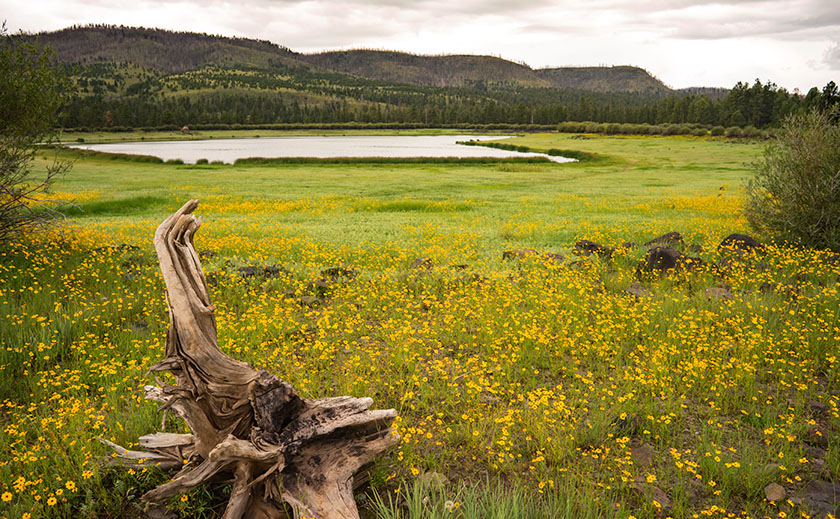
Yesterday we drove up to Greer for lunch, expecting to see a barren  blackened valley. We didn’t find that. We saw the burn scar along the mountain ridge flanking the valley’s east side, but the valley floor seemed untouched. The Molly Butler Lodge was unchanged and even the Greer Peaks Lodge, reportedly damaged by the fire, had long been repaired and open for business. What had changed however, was the little town of quaint cabins has become a community of large expensive mansions that were second homes for the wealthy. With its proximity to the Sunrise Ski Resort, Greer was looking more like Vail, without the expensive downtown shops.

Cinder Hill Ranch
A barn at the base of a volcanic cinder cone on a rainy afternoon in Greer.

We stopped at the crowed Rendezvous Cafe and had lunch. The food was great and we took in all the kitsch cluttering the walls (why is that still a thing?). While we ate, we watched hummingbirds fight over the feeders outside. On the specials board, they had home-made cherry cobbler, so we couldn’t pass that up and added a dollop of ice cream. “That’s some mighty fine cherry pie, ma’am.”

Last Cast
A father and kids make one more cast before the rain starts on one of the Greer lakes.

After lunch, we vainly searched for our little cabin Perhaps it fell victim to the fire, or maybe they tore it down to make room for a McMansion. In either case, we couldn’t find it. After we gave up looking, we drove around taking pictures until a light rain started. It seemed like a good excuse to call it a day and head back to the trailer for an afternoon nap. We left Greer behind assured that it was fine and we’d visit again.

P.S. Since this is our last day in Springerville, we’ll be posting the results of “The Great Springerville Mexican Food Shootout” this afternoon. Stay tuned for that. For now, Queen Anne and I are busy watching the eclipse.

Till then … jw

Casa Malpais

One of the things tourists do upon arrival is to visit the city park. I don’t know why, but when you browse the brochures, the local park is usually at the top of the list of to-do things. For example, San Francisco has the Golden Gate Park, there’s Central Park in New York, and Griffith Park in Los Angeles. Phoenix has the Margaret T. Hance Deck Park, but I don’t think anyone has ever gone there. These are open spaces within the city that their leaders felt important to protect from development. Springerville has Casa Malpais which isn’t really a park in the traditional sense of the word, but rather a fourteen acre archaeological preserve that the city owns and maintains. In other words, it’s a Pueblo Indian ruins.

Listed on the National Register of Historic Places since 1966, Casa Malpais was built on a basalt ledge overlooking the Little Colorado River a couple of miles north of Springerville. The Mogollon people lived there from 1250 to 1350, before abandoning the site. Frank Cushing was the first European Archeologist to visit the Pueblo in the 1800s and the University of Arizona did partial excavations a hundred years later. The findings of that dig are on display at the museum on Main Street back in town.

Queen Anne and I wanted to see Casa Malpais yesterday, so we stopped by the museum to get directions. We found out that the pueblo is not open for self guided tours, but guides take visitors out to the site three times daily. Since it only cost $10.00 per person ($8.00 for geezers), we signed up for the next bus. As we waited for our tour, we watched a twenty-minute background film that explained the history and what to expect. The museum hosts made sure we had sturdy shoes, sun block and water before we left. At 1:00 we (just the two of us) boarded the shuttle for what was a private tour. After making sure we had all of our gear,  Phil, our guide drove us to the scene.

When we arrived we got off the bus and I slung my camera bag over my shoulder while Anne threw some water in her purse/backpack thingy. Phil asked if we didn’t want to take a walking stick, so we each grabbed one from the rack. Looking up at the cliff, I thought, “This will be fun.” I didn’t see an obvious way to get up there. After we were ready, Phil explained, “The trial over there used to be the only one until the archaeologist brought a drone to film the site a couple of years ago. After studying the films, they realized that there was a second path up the ledge, so we’re going to go up this way and come down on the old trail.” I wondered what he was talking about, I couldn’t see a trail in front of us much less the one over there. While we’re at it, I don’t see any ruins up there either!

Pottery Sherds
At the door Kiva’s door is a display of pottery sherds for you to examine. You’re welcome to pick them up and look closely, but please put them back so that others can have the same opportunity.

We started walking up where the bigger rocks were kicked aside until we got to flat rocks that were reinforced and cemented in place. Ah, a trail — I get it. We’d move forward until we got winded, and Phil would conveniently stop and find something to talk about long enough that we’d catch our breath. The walking stick helped me keep my balance with a camera on one shoulder and bag on the other. Before we knew it, we reached the Grand Kiva — a large meeting hall — with basalt stone walls four-foot tall and equally wide. We listened as Phil talked about two hundred men packed in the smoke-filled ceremonial room. Then we went up more steps till we got to the 150 room apartment house were we heard stories of the ancients and how the volunteers take care of it.

Casa Malpais Pueblo
The pueblo at Casa Malpais has over one hundred fifty rooms, some of which have never been excavated. In the background is the town of Springerville at the foot of the White Mountains.

As we walked around the pueblo’s back side, Phil took us aside toward the cliff wall. “This is the lost canyon,” he said pointing at where the lead edge of basalt columns had pulled away from the original cliff. “Jeff and I have explored back there,” he said in such a way that you knew he had a genuine love of this place. Then he showed us three rams head petroglyphs carved into the rocks. “That one marks the summer solstice, the one on the right is the spring equinox and the one in the middle lines up with the cross quarter.” I would never had seen them, much less got a photograph if we were on our own.

Lost Canyon
Behind the Pueblo is a place where the leading edge of basalt columns have pulled away from the cliff. See if you can find the three rams head petroglyphs carved into the rocks.

We spent two hours on the ledge listening to Phil explain what he knew and us asking questions like a couple of six-year-old. He answered what he could and was honest about what his speculations were. “I wish I could go back 800 years to know that answer, but my best guess is … ” Before we knew it, we were back at the bus. Neither of us had fallen and I hadn’t dropped anything into a bottomless crevice, so I counted the day a success. When I mentioned this, Phil said, “Yeah, last month I went out with four and came back with two. My boss said, this is not good.” On the drive back he told us that story. If you’d like to hear it, sign up for a tour and ask Phil.

Ah, Joy

Oh, the joy of sleeping under the covers with the windows open. We’re in Eagar, Arizona – about four miles west of the New Mexico border. Outside, the temperature is a crisp fifty-two degrees. In Phoenix we won’t see these temperatures until Halloween. Queen Anne is still contentedly snoring in bed, so all’s quiet in the world. I see a cloudless sky through the window and the sun is about to clear the next door trailer which will make it all but impossible to type, so I’ll be quick about my report.

Yesterday’s trip was a pleasant and uneventful six hours. Two of those hours we spent traversing the Phoenix Metropolitan area to Fountain Hills where we stopped to top off the tank and buy some road food. We phone-waved Jeff as we passed his Scottsdale house. Not expecting our call, he offered to put shoes on and meet us for a bite, but we declined because we were already moving.

Fountain Hills is the point where I feel we’ve finally left town. From there we drove the Bee-Line Highway, climbing out of the Valley of the Sun to Payson’s 6000 foot elevation. We noted each time Fritz’s outside temperature indicator dropped from the low 90’s to the high 80’s. That doesn’t seem like a lot until you factor the hour and a half driving time. In Payson, we headed east on Arizona Route 260 and made the last ascent up the Mogollon Rim, and breaking through the 7000 foot elevation. From there, the rest of the way was a gentle descent. Our next way-point was Showlow and back on US Highway 60, ironically the same highway we took out of Wickenburg.

It was almost 3:00 pm when we reached Round Valley — a five-mile circular flat at the foot of the White Mountains — containing the yin yang towns of Springerville and Eagar. Springerville is on the north along US 60 while Eagar is on the south along AZ 260 with Main Street connecting the two highways (Yes, I know they’re the same roads, but there’s a method to my route madness that I’ll ‘splain someday). We stopped at the local Safeway for provisions and a bite to tide us over until dinner before checking into our campgrounds.

About our campgrounds … all I can say is that I’m glad that I went to Alaska last year. This place is somewhere between Watson Lake and Peace Park Gardens in Vancouver, but that’s a very large spectrum and I consider this in the bottom percentile. It’s certainly not a resort like where Fred and Deb are working. It is small and quiet with mostly permanent residences and few spaces for us transients. We picked it for the WiFi reviews and the price. The price reflects the lack of facilities (no showers). When we came in, the hosts had just finished helping a guest with a grand fifth-wheel (“The largest we’ve ever had,” he told me), before helping us with The Ritz (“The smallest one we’ve ever had”). Thanks … I guess. Anyway, behind The Ritz, we have a lovely private space under large Ash trees for sunset cocktails; how could things be better?

This morning. we’re going to spend time to lay out an itinerary for the week. We have a lot on our list and we need to rank it. One item on the list is the 2017 Great Mexican Food Springerville Shootout. Springerville has two restaurants that we like and we’re going to offer up our two cents on (last night’s dinner was at one of them — more later). We also need to spend the morning knocking off the rust on our camping skills, a fact that became obvious to us during set-up yesterday. The adventure awaits and I’ll have lots of photos for you.

Till then … jw

Springerville, Here We Come

It’s almost the middle of August. Queen Anne and I got our monthly allowance and paid the bills, but we have a couple of bucks left over and they’re burning a hole in our pockets, so we’re getting out-of-town for a week. The plan is to head for the hills … literally. To be precise, we’re off to Springerville and the White Mountains. Once again we’ll be camping in the trailer, or as my friend, Jeff once said, “We’ll be taking the Mercedes and spending a week in the Ritz.” That joke won’t be funny anymore if we ever get a different truck.

Normally we escape the desert’s heat at the north rim. We love going there because there’s nothing to do. So we pack all of our crap and do nothing for a week … except for sleep in the cool air, eat, snooze, drink,  slumber … and then take a nap. That was before we were doing this blog, and there’s no Wi-Fi up there. There’s also no radio, phone coverage, television or any other form of communication … well, maybe smoke signals, but I’m lost without auto-correct.

We picked Springerville — actually, the town of Eager which is next door — because it’s central to a lot of touristy stuff. We found a campground that (in reviews) has decent Wi-Fi, so we’re going to go play Tommy and Tammy Tourist and write about it … just like last summer. Won’t that be fun? I hope you’ll join us.

Rich Hill Rainbow
As an afternoon storm moves north, a rainbow touches a peak in the Weaver Range known as Rich Hill. Hmm.

PS: This is a new picture that I put up on my site a few moments ago. I hope you’re not tired of these storm photos because I’m having fun with them. It’s just a phase I’m going through, I’ll get over it.