Beer Can Picture of the Week

Beer Can - An uncouth visitor left an empty beer can near a cattle tank on the Babbitt Ranch.
Beer Can – An uncouth visitor left an empty beer can near a cattle tank on the Babbitt Ranch in Northern Arizona.

If you drive north on US Route 89 from Flagstaff, you get to see one of the best scenic views in the country. To get there, we need to get around the San Francisco Peaks—the remains of an ancient volcano, and they rise over 12,000 feet—Arizona’s high point. Route 89 is on the east flank of the peaks and winds through Flagstaff suburbs that suffered fire and flood damage this spring. As the road climbs a gentle grade, the scenery changes from open meadows full of new homes to a ponderosa forest. There was substantial fire scaring, but many tall, red-barked trees survived.

At the top of the hill, the four-lane highway briefly flattens before you reach the Sunset Crater National Monument entrance road and the 7288-foot elevation marker. A mile further, the road suddenly drops from its mountain elevation to the Little Colorado River Bridge, 3100 feet below and 35 miles away. On an exceptionally clear day, you can see into Utah—I swear.

This vista encompasses every rainbow color. On the left, the dark green pine trees grow down the mountain slope until they make way for lighter green junipers and then the yellow grass-covered cinder cones on the Babbitt Cattle Ranch. The twenty-one miles of perfectly straight blacktop divides the east side from the west. On the east side, patches of black lava flow give way to the distant Painted Desert colored in hues of reds, whites, greys, and purples. Above everything, the deepest blue skies—a color they don’t make anymore—tie the canvas together.

Every time I see this scene through my windshield, I have a smile on my face. My joy is probably because I’m on my way to someplace fun, like Lake Powell, Lee’s Ferry, the Grand Canyon, or (shudder) Utah. As I drive down the mountainside, I habitually switch my dash view to see if I can recover my gas mileage before I hit the bridge. It keeps my mind occupied for the next half hour. As you all know, I’m easily amused.

Except for a few visits to Sunset Crater and Wupatki National Monuments, I’m usually passing through this wonderland. But, during our July visit to Flagstaff, Queen Anne and I came to the mountain’s north side to photograph the cinder cones in the San Francisco Lava Field. They’re technically on the private ranch owned by the Babbitt family. The Arizona pioneers that have been successful ranchers, merchants, and politicians.

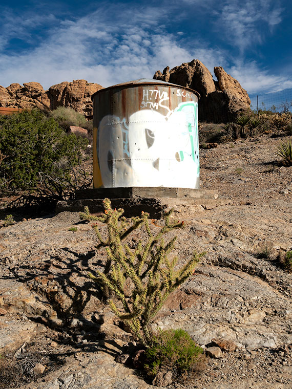
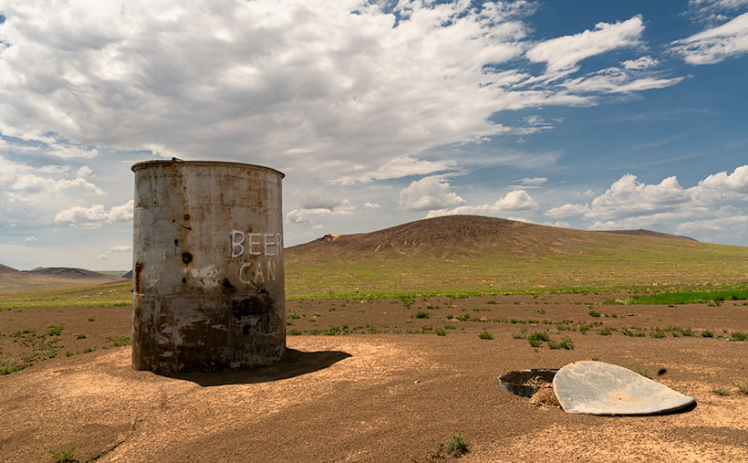
Before we drove out to the ranch, I checked in at their store in town to see if we needed a hall pass. “No, if the gate is open, you can enter as long as you’re respectful and drive on the roads.” Taking the caution to heart, I was surprised when we reached the old trading post that there wasn’t even a gate to open. The dirt road was so smooth that we didn’t tax our Jeep’s capabilities—not even its four-wheel drive. It’s only a couple of miles to the lava field, but before we got there, we drove by a cattle tank where some uncouth slob left an old beer can. I was so upset that I stopped to document what the thoughtless cretin had done. The picture came out so well that I made it this week’s featured image. I call it Beer Can.

As you might have figured out already, it’s not actually a beer can but graffiti that some vandal painted on the side of one of the ranch’s metal water tanks. They’re used to hold water for the cattle during the dry season. Indeed, the lettering is still vandalism, but one that appeals to my perverted sense of humor. Besides the tank, I don’t know what the trash can lid is. Perhaps it’s a cache to store surplus hay for when a herd is in the area.

An unnamed volcanic cone appears in the background, and it doesn’t seem very high until you try climbing it. Neither Anne nor I tried scaling anything on this trip because there weren’t any stairs for me to bitch about, so as usual, Anne stayed in the Jeep reading her Kindle while I ran around taking pictures.

You can view my Web version of Beer Can on its page by clicking here. We have a month’s worth of photos from the lava field, so we’ll be spending October here. I hope you enjoy this week’s pictures and come back next week when we present more. Be sure to join us then.

Till next time
Jw

BTW:

We recently discussed making a Route 66 photo trip and producing a large coffee-table book from the new photos. After burning down my calculator, we’ve put off any such trip until later. We’ll wait and see what happens next year.

Water Tank Picture of the Week

Water Tank - The Richardsons added a water tank on their to ensure there was water during dry periods.
Water Tank – The Richardsons added a water tank on their property to ensure there was water during dry periods.

 It’s a miracle! We changed seasons on Tuesday, and Thursday night, we had our first summer rain. Getting rain during summer isn’t unusual, but getting it so soon was. It was nice to break our six-month dry spell finally. It wasn’t a deluge but enough to tamp down the dust.

Our storm cell came through at 1:00 am, and I listened to the thunder approaching in bed. The weather service says that you can tell how far away the strikes are by counting the time between the flash and the thunderclap. “If you count the number of seconds between the flash of lightning and the sound of thunder, and then divide by 5, you’ll get the distance in miles to the lightning: 5 seconds = 1 mile, 15 seconds = 3 miles, 0 seconds = very close.” As I lay in bed, I counted one, two, three …, then there were a couple of strikes where I didn’t get to finish the one. That’s when I got up.

When I did, Queen Anne was already outside—in the dark—dressed in a T-shirt and flip-flops moving flower pots around so the rain could water them. I scolded and reminded her about the 3 S’s (snakes, spiders, and scorpions). She seemed oblivious to the blue-white lightning streaking dozens of miles across the black sky above her head. At first, I was concerned that the strikes would start another wildfire because they struck close around us. When the rain started falling, it eased my mind, and I quickly got bored and went back to bed.

According to forecasters, we’re supposed to have an above-average monsoon this season. That’s good because our drought has lasted nearly 20 years. I’m not optimistic that I’ll see a recovery in my lifetime. Climatologists told us of 100-year droughts in the past, and they conjecture that those dry periods may have caused the Anasazi, Sinagua, and other pueblo tribes to move in search of water.

Water has always been a concern in the desert west. That’s as true today as it was when the Richardsons homesteaded their place in Union Pass. There’s a spring near the pass that supported their cattle and orchard. Can you imagine hauling water up 3000′ from the Colorado River? Even with a spring, they need a healthy water reserve to get through the dry months.
As you can see in this week’s photo that I call Water Tank, they built a good-sized tank on the property for water storage. From this image, I guess the tank dates back to when they made the gas station. The concrete foundation work looks similar to that of the pump island.

I’m sure vandals added the graffiti and bullet holes to the tank’s side after the family moved off the property. They are another example of vandalism that supports my argument that the BLM should set this homestead aside for protection. Otherwise, these ruins won’t be around much longer.

I hope you enjoyed our month at the Richardson Homestead. You can see the larger version of Water Tank on its Web Page by clicking here. Next week we begin a new project in a different location. Hopefully, it will be someplace cool. Please come back then and see what Queen Anne picked for us.

Till Next Time
jw

Big Horn Tank Picture of the Week

We’re down to the final month of this gawd awful year. For one, I will be happy to get my vaccination and venture back out into the world again—well, right after you get yours, and I see that you don’t get sick and die from it. I’m afraid that it’ll be months before it’s my turn because I’m too young and pretty. So, because it’s a short month, and Queen Anne has abandoned me, we’re going to explore a road that’s both close by but too expansive to cover in one day.

This month’s focus will be on a road, unlike what we’ve covered on this platform before. It’s not even dirt. It’s a road that stretches from Jacksonville, Florida to Santa Monica, California. It’s also the longest possible way to cross Texas. When Anne and I visited Deb and Fred in Austin several years ago, I was dismayed to see a highway sign that said our destination was further off than the two states through which we’d already driven. I’m, of course, talking about Interstate 10.

Calm down, we’re not going to do the whole thing in one month, and I’m not ready for a lifetime commitment (ask Anne). For December, we’re going to point out the landmarks that I enjoy seeing between Phoenix and the Colorado River. Even with that limitation, there are too many to fit into four Sundays. We’re not even heading in a particular direction; we’ll talk about each place as I get to it.

If you’re like me, you loath driving cross country on the Interstates, but they are the most efficient route when your time is limited. I’ve made countless trips between Los Angeles and Phoenix since moving here a half-century ago, and the flat desert always was the worst grind—river, flat, mountain, flat, mountain, flat, town. After I learned some about the mountain ranges, it was more enjoyable to know that Courthouse Rock was coming up on the south side or that I could spot the abandoned solar observatory on top of Harquahala Mountain. It was like saying, “Hi” to old friends as we passed.

This week’s featured image was taken in the Tonopah area. From east to west, you’ll pass the Palo Verde Nuclear Generating Station, stop at Tonopah Joe’s for gas and heartburn, then on the north side of the highway—where Salome Road crosses—there’s a prominent horn mountain, called Big Horn Mountain. It’s the centerpiece of a wilderness area that’s the same name. Actually, there are two wilderness areas separated by a dirt road that I’ve yet to discover. These are the Big Horn Mountains Wilderness and the Hummingbird Springs Wilderness across the street. You can do backflips across the road from one to the other.

On the plains south of Big Horn Mountain Wilderness Area, is a rusty tank meant to provide water to cattle on the open range.
Big Horn Tank – On the plains south of Big Horn Mountain Wilderness Area is a rusty tank meant to provide water to cattle on the open range.

This week’s featured image that I called Big Horn Tank was taken from the Harquahala Plain off of the Salome Road. There on the open range, I found a rusty water tank for an interesting foreground. I think that rust is a photographer’s favorite color, and I like how the white PVC pipe accents the tank. The other thing I see is how little vegetation cattle have for grazing. They don’t eat creosote (would you), so they only munch on the yellow grass.

You can see a larger version of Big Horn Tank on its Web Page by clicking here. Be sure to come back next week for another roadside landmark from Interstate 10. Tomorrow, I have to phone the Queen to see where I’m allowed to go. Wait till I tell her what happened to me as I was leaving Algodones yesterday—she’ll never let me out of the house again.

Until next time — jw

Tin Shed Picture of the Week

It was the fourth article about my time shooting pictures in Colorado’s San Juan Mountains when Queen Anne burst into my office—all akimbo—and began scolding me. “Fred and me this, and Fred and me that. I haven’t had press in a month.” I felt like the guy in that Toyota commercial trying to answer his wife’s question. “I’m sure there’s a right answer here.” I quickly flipped through my brain’s Rolodex of apology cards, before I realized she was right. I had to change tactics, “If you want press, you have to put your butt in the truck.” I had her.

Last week, I announced that I was leaving for one of my back-road photoshoots, and I wouldn’t be back until after dark. I packed my gear and went into the house to grab my cooler stuffed with water and snacks. When I got back to the garage and jumped into Archie’s driver’s seat, guess who was sitting shotgun? Yes—it was Her Highness.

Now that her ego is satiated, I can tell you about October’s topic. I picked out a back-road that goes from Bagdad to Williamson Valley—northwest of Prescott. On my Gazetteer map, it’s identified as Behm Mesa Road, but it had several other names as we drove it, like Camp Wood Road, Forest Service 21, or Yavapai County Route 68. The map says it’s broad and well-graded, so a passenger car should make it, but there are sections on Behm Mesa’s shoulder that are rough and rutted, so I’d feel more comfortable driving at least a pickup truck with some ground clearance.

The terrain starts in Bagdad with large boulder fields interspersed with grassy flats on the mesa tops. As the trail gains elevation, the trees change from scrub oak to juniper and ponderosa pine near the Santa Maria Mountains.  After that, the road descends into the open grasslands found around Prescott. There are a couple of cattle gates that you have to open (and close) as you cross private ranches. Most of the route’s middle section runs through the Prescott National Forest, including a part along the edge of last Augusts’ Sheridan Fire. It’s weird/unusual to see a healthy forest on the road’s north side while the south side is black and barren.

Tin Shed - An old corrugated tool shed along the Camp Wood Road.
Tin Shed – An old corrugated tool shed seen along the Camp Wood Road.

I took this week’s featured image near our starting point. As the road leaves Bagdad, you slowly travel on the shoulder of Behm Mesa—where the rough part is. September’s heavy rains may have been the cause of the ruts, and the county hasn’t regraded it. Shortly after it makes its way to the mesa’s top, you reach the first gate at a ranch house, with black cattle hanging around a water tank. Just past the tank was this tin shed in a golden grass field that had a nice contrast against the deep blue sky (opposites on the color wheel). You all know that old buildings—like this one—are a favorite subject of mine, so I had to get out and snap a picture. I call it Tin Shed.

You can see a larger version of Tin Shed on its Web Page by clicking here. I hope you enjoy viewing it. Next week, we’ll have another image to show from the drive that Queen Anne (she gets make-up press) took on the Camp Wood road.

Until next time — jw