Placerita Post Office Picture of the Week

It was lust for gold that lured men to the Weaver Mountains in southern Yavapai County. They heard stories of miners plucking nuggets from the ground and, in just a day, returning to camp a wealthy man. The fever for gold outweighed the risks of hostile Indians, treacherous mountains, poisonous snakes, and oppressing heat from the relentless sun.

Prospectors discovered several veins of the precious mineral with Rich Hill at their center. Pauline Weaver’s party started the rush when they accidentally found placer gold on the hill’s top. Boomtowns sprung up surrounding Rich Hill. The camps in Stanton, Octave, and Yarnell all had ore-bearing mines. There were so many claims on the hill; it’s a wonder that prospectors didn’t dig into each other’s tunnels. But it only took 20 years for the gold to dry up; as a result, when Anson Wilbur Callen arrived in the 1880s, he decided to prospect somewhere else.

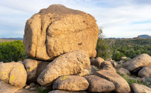
If you flew a small airplane due east of Yarnell, you’d see a geographic anomaly. Instead of the regular distribution of peaks and hills in the Weaver Range, there’s a 2-3 mile gash between Antelope Peak and Rich Hill. From Yarnell, it runs northeast, and it looks like a score on the top of a loaf of bread. It’s very evident on a topo map or Google Maps.

There’s a natural divide in the gap’s center, and Antelope Creek drains south along the east flank of Rich Hill. Arrastre Creek flows in the divide’s north side (Arrastre is the Spanish word for a drag, as used for mining). Anson set up his camp where Arrastre Creek flows out of the canyon.

By accounts, Anson Callen was a big man and weathered beyond his age. Locals called him Old Grizzly at the age of 40. When he set up camp, his initial task was to create a reliable water source, so he dammed up the creek. As he dug a five-mile water ditch to his base, he uncovered two pieces of gold that earned him $550. There are more stories of finding large gold nuggets in the area—one of which was four pounds that the assay office valued at $900 ($107,792 in today’s market). Before Anson knew what had happened, the town of Placerita sprung up around his claim.

On Tuesday morning, I dragged my friend—Fred—out of bed, and at 5 a.m., we drove his Toyota FJ into the sunrise to find the ghost town of Placerita. As I’ve written, real ghost towns rarely have any remaining artifacts. Maybe there’s a pile of timber or a concrete slab, but never an intact building. My research showed that Placerita had a standing stone cabin, and I needed to photograph it.

Ruins in the Woods - From the roadside, we could see the remains of one of the town buildings, but we couldn't see an easy way to get to it.
Ruins in the Woods – From the roadside, we could see the remains of one of the town buildings, but we couldn’t see an easy way to get to it.

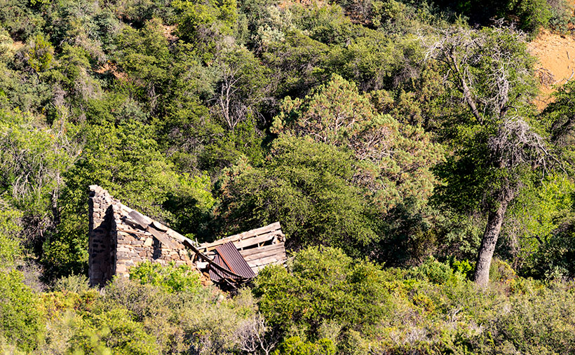
When we got to the area, we drove by a shed with a collapsed roof, but the brush was so thick that we couldn’t find a path to it. Instead, Fred drove down to the creek crossing and parked in an apparent campsite. We intended to hike up the creek, find the buildings, and photograph the ruins. Indeed, they were built along the banks. We soon discovered that walking in a dry creek bed wasn’t the best thing a couple of septuagenarians should do—especially a pair that has a hard time walking on carpets. We struggled for what seemed like a couple of miles, occasionally falling on the rocks and swatting at attacking insects.

Placerita Post Office - The 30 townspeople were served by this Post Office from 1896 to 1910, when the gold ran out.
Placerita Post Office – The 30 townspeople were served by this Post Office from 1896 to 1910 when the gold ran out.

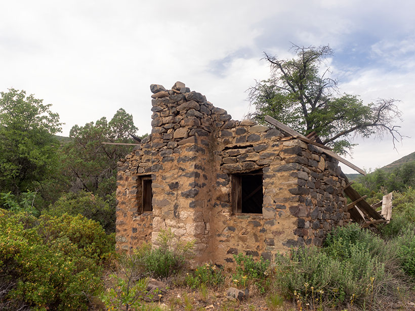
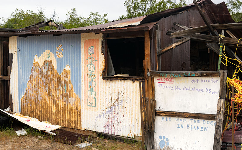
Finally, we gave up and started back to the truck, but instead of the creek, we found a cattle track that had boot prints. We followed it to a clearing where—you guessed it—we found the collapsed building. We spent some time shooting photographs from different angles, including this week’s featured image called Placerita Post Office. About half the walls were standing, but the timbers were full of termites, and that finally caused the roof to collapse.

We never found the stone cabin—or at least we thought we hadn’t—but after I got home and did some further research, I found a photo caption that said, “It has been reported that the roof has collapsed since this picture was taken.” We did reach our goal; it’s just ten years too late. I also found out that the stone building that we shot was the town’s Post Office—built in 1896 and closed in 1910. As a federal building, it was built more durable than the rickety shacks that the miners cobbled together. It makes sense that it outlasted the rest of the town.

You can see a larger version of the Placerita Post Office on its Web Page by clicking here. I hope you enjoy it. Come back next week to see the work I’ve shot along the road to Placerita.

Until next time — jw

Tom Reed Mine and Elephant’s Tooth Picture of the Week

After publishing last week’s post, I lingered in my office for a while with a nagging question. It was more of a puzzle than a burning issue, but it would persist until I solved it. My enigma was this: If Lt. Whipple completed his survey in 1854, and the railroads were already following his trail, why in 1926 did the Highway Department run Route 66 through a rugged mountain pass when they established the National Highway system? Wouldn’t it be faster and cheaper to follow the railroad tracks down to the Colorado River? I used up over half of my monthly Google query allotment trying to understand their logic. After distilling some facts that I uncovered, and with some fantasy time travel, I concluded that the department wanted travelers to go through the shining city on the hill—Oatman. When the mines were still open, Oatman was a bustling city, with a good hotel, restaurants, bars, groceries, and gas stations.

Oatman Main Street 2020 - The crowds of tourists are gone, the stores are shuttered, and even the burros are social distancing.
Oatman Main Street 2020 – The crowds of tourists are gone, the stores are shuttered, and even the donkeys are social distancing.

Arizona has two types of ghost towns, and to paraphrase a line from Frank Zappa’s song Camarillo Brillo, there are real ghost towns, and there are Walmart ghost towns. Real ones are scattered throughout Arizona’s mountains and plains. Places like Cochran, Cherry, and Ruby. If you drive there in your Jeep, you’d be lucky to find a standing building, but—most of the time—only their crumbling foundations remain. As for the latter towns, they’re thriving communities. Arizona’s big four include Jerome, Tombstone, Bisbee, and Oatman. People still live there, and more importantly, tourists visit by the busload. They come to drink in the saloons, eat lunch in the bordellos, watch the fake gunfights, ride oar carts into the mine shafts, and feed the wild donkeys. I wouldn’t be surprised to learn that these towns generate more annual revenue today than the mines ever did.

Before my first Oatman visit, I already knew the image that I wanted to take. Ansel Adams—the photographer that most inspired me—had already made it. Mr. Adams must have blackmailed God because he had Him move heaven and earth into compositions that no other mortal photographer ever saw. The photo that I’m referring to is in one of his books and is called Tom Reed Mine, near Oatman, Arizona. It shows a cluster of buildings on enormous washtubs with a pinnacle in the background. When I was younger, I tried to visit the places he captured so I could see what motivated him. That was my way of learning from a master. But in all my visits, I never found those impressive mine structures.

When Queen Anne and I made our Route 66 journey last month, snapping pictures in Oatman was the last thing I wanted. We were avoiding people, so stopping in a crowded tourist trap was out of the question. But when we arrived, the streets were empty of people wearing funny hats, loud shirts, sandals with black socks, and speaking in foreign tongues. The merchants had shuttered the windows, and even the wild burros—the stars of the Oatman experience—were social distancing. I had to stop and document this weird moment—Oatman had turned into a real ghost town.

Tom Reed Mine and Elephants Tooth - The concrete foundations are all that remain of the magnificent structures that Ansel Adams photographed.
Tom Reed Mine and Elephants Tooth – The concrete foundations are all that remain of the magnificent structures that Ansel Adams photographed.

As we drove out of town through the south side, the sun was low in the sky and casting lots of color on the hills—including the pinnacle that Adams captured. I stopped on the road where some concrete foundations lined up below the white outcrop—that I now know is called Elephant’s Tooth—and took this week’s featured image. I call it Tom Reed Mine and Elephant’s Tooth. We spent less than 15 minutes at that location before driving on.

Since we’ve been home, I was curious about the Adams photo, so I got it down from the bookcase and searched for his rendition. I wanted to see the buildings that he shot again. I’ve never been able to find them no matter how much I scoured the town. Upon examining his image, I realized that he took that photo in 1952, and people have since torn down the structures. The only trace of their existence is the concrete terraces in my picture. When I took my photo, I stood within ten feet of where Ansel Adams worked his magic, and we were both inspired by the same subject. I was so close to being in the presence of greatness—I only missed him by 68 years. My life can go on now.

You can see a larger version of Tom Reed Mine and Elephant’s Tooth on its Web Page by clicking here. I hope you enjoy it. Next week, we’ll pass by the Warm Springs Wilderness on our way to the Colorado River. I hope you’ll join us then.

Until next time — jw

Harquahala Sunset Picture of the Week

Oh my, it’s another Sunday already. It’s the last Sunday of our Harquahala trip, of the month, the year, and the decade. I should have thought of something profound to memorialize this moment. Alas, I’ve been too busy staring at all of these trees to notice a passing forest. I’ll try to do better ten years from now.

For this week’s episode, we’ve turned the corner, literally. Anne and I had been traveling southwest on the Eagle Eye Road, and to continue, we turned right on the Salome Highway, which runs northwest from Buckeye to Salome. At one time, the highway was a detour while they built Interstate 10. Now, both roads are free of traffic. As when we made stops along the way, I pulled off on the broad shoulders, but I didn’t need to. There was no traffic to block, so I could’ve parked in the middle of the road.

As we drove toward Salome (“Where she danced” Dick Wick Hall; one of Arizona’s famous humorist and former Salome resident), the day grew late. The long shadows on the mountain began to look like a minimalist graphic in the style of an Ivan Earl painting, or a Scotty Mitchell pastel. So, I searched for a spot where I could take a picture of the mountain behind a sea of creosote. I found such a place near a large ranch. So I got a chance to shoot this image with and without buildings in the distance. I preferred this version, and I called it Harquahala Sunset.

Harquahala Sunset - With the deep shadows and minimalist styling, this photo reminds me of the style of some artists that I admire.
Harquahala Sunset – With the deep shadows and minimalist styling, this photo reminds me of the style of some artists that I admire.

The part about “without buildings” is a lie. As I processed this picture, I combed through it, looking for dust spots—a regular part of my routine. That’s when I discovered the ruins of the 1930s solar observatory. At the top of the highest center peak is a white tower and utility building. They’re abandoned now, but a few miles behind us, there’s a ten-mile road that goes to the mountain’s top. It’s a challenge that is too much for Archie, but I’d like to take that trip someday.

You can see a larger version of Harquahala Sunset on its Web Page by clicking here. I hope you enjoy viewing it. Next week, we’ll be talking about a new back-road trip somewhere in Arizona.

Until next time — jw

George’s Camp Picture of the Week

George's Camp
George’s Camp – Written words on the whiteboard sign note the passing of George, the painter.

Serendipity is a word that means finding something different from the thing you were trying to find. It was so overused back in my flower child days that I don’t like to use it. I wish there were a better term—but there isn’t—that describes what happened to Fred and me this week.

As I wrote in last week’s post, my project for April is to find exciting things to photograph in Nothing—the abandoned gas stop on Highway US 93. It’s a voluntary exercise to help improve my creativity. Nothing is in the middle of nowhere; I’ve been pouring over my maps the past week. I found that on the north side of the gas station, there is a sizeable lava flow. It’s spring, so there is new bright green growth on the desert plants, and that should contrast well against the black rocks. Even better, I found that the flow’s west side covered a wash or creek. Over eons, the water has opened a channel through the hardened magma, and it’s called Black Canyon (I know, there must be hundreds of Black Canyons in Arizona).

After deciding to try to follow the back trails and visit the canyon, I asked Fred if he’d like to sit shotgun. I figured that he could change a flat if needed, and he always carries his cell phone which might be handy. It surprised me when Deb permitted him to go out with me again, but only after I swore up and down that we’d be home by dark.

On Thursday we packed Archie and set out on a new adventure. We got a late start because I wanted the proper light, but the day ended in overcast, so I gave up on beautiful sunset pictures. The topo map that we brought showed a jeep trail, leading to the canyon; then we’d have a half mile hike up a pack trail at the end. As we crept along the so-called road, I knew that I had to stay left at each intersection that lay before us. The last turn put us on a rutted track where we maneuvered between boulders, but at its crest, we saw Black Canyon in the windshield which meant that we were driving along the pack trail. We would have done better with Fred’s ATV.

Well used Ford
Well used Ford – A parted out Ford truck is abandoned in camp.

As we descended to a wash we came upon a couple of sheds, and I thought, “Oh no! We’re reliving the night we spent at Stephen’s house.” You’ll remember him from our first outing where we got trapped inside private property. I got out of the truck and started calling. No one answered, so we walked around both sheds trying to find the owner. We saw the sign in the first photo that raised more questions than had answers. What Fred and I stumbled upon is—as I call it now—George’s Camp.

Macrame Tee Pee
Macrame Teepee – A hand made teepee provides a little shade in George’s front yard.

As we wandered the campsite, I wondered about George. Did he sell his paintings, had I ever seen one? How did he get groceries? What made him become a recluse? Of the artifacts we found, they seemed fresh enough to suggest that George’s passing was recent. If he had any property of value, someone had already taken them. It was apparent from the words on the sign that someone felt sad that George has moved on.

George's Cup
George’s Cup – Decorating a dead stump are a collection of household items. I wonder if George wrote the inspirational message inside of the cup.

We delayed our canyon hike long enough to look at the art pieces George had left. I tried to imagine the kind of soul that he was, and I got a bit sad that I missed meeting a fellow artist. Of the scattered yard art, the tree ornaments moved me the most, and that’s why I selected it as this week’s featured image. I call it George’s Cup. It already has a picture frame.

You can see a larger version of George’s Cup on its Web Page by clicking here. I hope you enjoy viewing this week’s post and next week; we’ll show another featured image from Nothing. Maybe by then, we’ll make it to Black Canyon.

Until next time — jw

Large Boulder Picture of the Week

Nothing Arizona Sign
Nothing Arizona – Only a crooked sign and empty building shell are all that remains in Nothing

My generation is probably the last to have a love affair with automobiles. For us, cars defined who we were. They opened the country for us to explore. Now that we’re old, most of our recollections are car-centered, and I’m an example of that. Over my life, I’ve owned a varied stable of vehicles; from ones German engineered to station wagons that the Griswolds from Family Vacation would reject.

The car that still gives me the most angst was the Camaro that my parents gave as a wedding gift for my first marriage. It was special because it was the racecar version built for the original Trans-Am series. To qualify for the races, manufacturers had to produce at least 1,000 units, and they had to sell them through their dealer networks. Very few Americans knew they existed. I knew, because I read racing magazines, and after I got back from my overseas tour, I hunted one down. Their moniker came from the option package number—Z/28. After the first batch quickly sold out, Chevrolet offered them to the public.

It was British racing green with a pair of broad white stripes on the hood and trunk. Ours didn’t carry the familiar Z/28 badge on its nose; instead, it just had the numbers 302 which was its engine size. Trans-Am limited the displacement to 5 liters, and that meant that it was the smallest V8 that Chevrolet put into Camaros, but those engines were specially built and had more horsepower than the other power plants available. Since it was a high revving motor, you couldn’t get air conditioning or (gasp) power steering. Because I raced mine, I added 10” wide wheels and fat tires which made it near impossible for my wife to drive.

At the collector’s car auctions, 1968 Z/28s sometimes go for over a hundred grand, and because mine was a low chassis number, I believe it could’ve been more valuable if it were in pristine shape. But, I was living in a lot of turmoil and planned to move to Arizona where I would need an air-conditioned car, so I got a thousand dollars on trade for a Vega—possibly the worst purchase I ever made in my life.

It was mustard-yellow with a single black stripe. I wanted the GT version because it came with gauges instead of idiot lights. The dealer didn’t have one with air, so they installed an aftermarket unit, which was like bolting a cinder block to the side of the engine. Because of the weight and engine vibrations, the compressor fell off when the bolts sheered—twice. All of the gauges worked except for the water temperature, which I noted to the dealer while it was under warranty. They said they’d order one, but I don’t think that they ever did, and wound up rebuilding the engine after it seized from overheating.

My horrible decision meant that I gave away the impractical car that I loved, to buy the practical car that I hated, and that includes all the awful station wagons we’ve owned. Its gas mileage wasn’t any better than my hot rod, and with a nine-gallon tank, our gas stops doubled. The engine vibrations were so bad that I carried a screwdriver and wrench because, at each fill-up, I had to re-tighten the carburetor screws. The only fond memory I have of that car was besting the local legend—Don Roberts—at a Big Surf event. He drove a different Vega—a station wagon. That was a nice feather to have in my cap.

My second wife and I went to Las Vegas, Bullhead City, or one of those destinations involving Highway US 93. We packed the Vega—it never deserved a name—and headed north for the weekend. We planned gas stops in Wickenburg, Kingman, and Vegas—or wherever. However, because of the Vega’s limited range, we had to stop again after climbing the grade after the Santa Maria River—at Nothing, Arizona. I had to pay a buck-and-a-half for gas, which was highway robbery at the time. That makes me the only person in the world to have bought gas in this month’s featured destination—Nothing—population: 4.

The abandoned store in Nothing is at the top of the pass between the Poachie and Aquarius Mountain Ranges. Its elevation is 3700-feet, and the terrain is part of the granite boulder field that stretches from Prescott to Kingman. The store, as they tell it was, ”built by four drinking friends having nothing better to do.” It was open only a couple of years before being abandoned. I don’t remember this, but according to Wikipedia, in 2016, Century 21 ran a promotion for father’s day with the promotion line, “Give Dad Nothing for Father’s Day.” They sold 24-hour deeds to property in Nothing. The current property owner was in on the joke and buyers could download a gift card and a “Certificate of Nothing” valid on June 19, 2016, only.

Large Boulder
Large Boulder – The landscape in the Nothing Pass is a boulder field like this delivery-van sized example.

So for April, I will be trying to make something from Nothing—pun intended—like this week’s featured image—Large Boulder. There’s some pretty country in the pass between the Santa Maria River and Burro Creek. My job is to find enough to produce four images for April. Do you think I’m up to it?

You can see a larger version of Large Boulder on its Web Page by clicking here. I hope you enjoy viewing this week’s post and next week; we’ll show another featured image from Nothing.

Until next time — jw

P.S. You should see my grammar checker going nuts over Nothing.

P.P.S. Speaking of old Chevys—this week I sat through a show that Queen Anne likes. I think its called The Kids Are Alright. It’s about a Catholic family with a gaggle of boys. They’re struggling to make ends meet, so they drive an old station wagon—a ’66 Chevelle. As I watched, I had to pause the show and show Her Majesty the station wagon’s nose badge. It indicated that the car had a 396 motor, but it wasn’t an SS model. Very rare and valuable.

Mobil Antlers Picture of the Week

A long time before we moved here, I remember driving through our little hamlet and noticing the old buildings in town. Queen Anne and I were traveling to visit my folks in Kingman, and after leaving Wickenburg, traffic stopped. Thinking it must be a result of an accident, I said to Anne, “We can detour around it by going to Congress.” It was ten miles out-of-the-way, but at least we’d be moving. It was when we reached the village that I saw the structures and said to her, “That’s so cool. I don’t remember this being a ghost town. I’ll have to come back and photograph it, someday.” (As an aside, my detour didn’t work because the accident was further north on US 93. We finally drove over to the river and took US 95, which put us several hours behind.)

There’s a reason why I didn’t remember those old buildings even though I had gone that way several times before. They weren’t there. After moving to Congress, that someday that I had set aside to photograph Congress’s historic district finally came. When I did, it disappointed me to learn that they’re a fake, like a back-lot movie set. The buildings are empty shells apparently used to display someone’s antique sign collection, but I don’t know why. It’s like someone threw up some structures as a tourist attraction and then quit before finishing.

The area of town at the  AZ 89 and AZ 71 junction isn’t the historic part of Congress. It used to be called Congress Junction or Congress Depot. The historical part of town was up Ghost Town Road near the mine. In this Wikipedia article, there’s a 1914 photograph that shows how it was. When the mine closed in the 1930s, the town moved to today’s location—lock, stock, and barrel. All of the buildings in the photo are gone. The land was scraped clean, including the mine structures. The only thing remaining is the old cemetery and a shed for Stephan—the mine’s caretaker.

Wouldn’t it be nice if someone bought and moved these buildings along the railroad tracks from old town? I don’t know, because there’s nothing to explain their existence. The only remaining business there is someone selling landscape rocks. Maybe you know the story and can share it with us, or perhaps, when I get a ’round-to-it,’ I’ll investigate and post an update.

Mobil Antlers
Mobil Antlers – An antique Mobil Oil flying horse is displayed over a pair of antlers at Congress’s fake garage.

I’ve pretty much ignored this part of town for the past three years, but since we’re featuring Congress during March, I wanted to show you what always catches my eye as I drive by them. It’s the Mobil Oil red flying horse sign. I’d like to have something like it to hang on the gable over my garage door—perhaps a Ferrari, Porsche, or one from Sunoco. To be accurate, however, my sign would be for beat-up Chevy station wagons.

In this week’s featured picture that I call Mobil Antlers, a set of antlers upstage the flying horse, so I concocted a fantastic story about it. It represents a tale about a red horse that soars high in the sky. He spots his prey in the meadow below—a handsome buck. The horse swoops in for the kill, and there’s a mighty struggle with the deer attempting to gore the soft underbelly of its attacker. Red-horse prevails and devours Bambi except for the antlers because they’re indigestible. Then I thought, nah—I’m not going to say that—it’s just too bizarre, and people will think I’m weird.

You can see a larger version of Mobil Antlers on its Web Page by clicking here. I hope you enjoy viewing this week’s image and come back next week when we’ll talk more about Congress.

Until next time — jw

Retaining Wall

There are hundreds—if not thousands—of abandoned towns and mines in Arizona. Most of them don’t have much to offer, because all of the things of interest have been taken away. As I pointed out in last week’s post about Anderson Mill, the good stuff has already been salvaged. In Arizona, there are about ten ghost towns, like Jerome, Bisbee, and Oatman where the residents were able to transform their community into a tourist destination, but the majority of them have returned to nature, and you’re lucky to find a concrete slab.

Retaining Wall - A retaining wall at the Anderson Mill made from surplus Army landing pads and steel plate.
Retaining Wall – A retaining wall at the Anderson Mill made from surplus Army landing pads and steel plate.

 Last week’s adventure to Anderson Mills is an example of my point. I would have been delighted if the sheds, trucks and other equipment remained on site. Alas, that’s not the case. At least the main-processing structure was still standing, probably because it was welded together and pirates couldn’t easily strip them. From what was left, I even got an idea of how the Anderson brothers cobbled together the plant with scrounged parts and probably no plans. My dad worked like that. He figured it out in his head and would slap things together. I should ask Fred—who’s a certified nuclear welding inspector—what he thought of the fabrication.

As I was shooting, I looked for strong elements of design; colors, patterns,lines—that sort of thing. As we were ready to make the trip home, I didn’t havemuch time to spend behind the camera. The most color that caught my eye rightaway was a retaining wall, built out of Army landing pads. The mica processingplant is gravity feed and sits maybe 50 feet above the bed of the wash. To makea level base up there, the Andersonsbuilt a reinforced embankment wall out of panels and then back-filled it withrubble.

When I took this picture of the week, I focused on the panels that had alternating yellow color values. I like that against the rusty steel corner plates. However, I didn’t notice the narrow gauge mine-car tracks holding the bottom together. It seems like an expensive piece of scrap metal compared with the other building materials used. I like the abstract feeling of this image, and I call it Retaining Wall. 

You can see a larger version of Retaining Wall on its Web Page by clicking here. I hope you enjoy viewing this week’s post and come back next week when we’ll show another featured image from San Domingo Wash.

Until next time — jw