There’s a place on US 89 about halfway between Page, Arizona and Kanab, Utah where the road gets lost. As you know, odd-numbered routes run north-south, but this section of 89 goes east-west for 60 miles between the two towns and right in the middle the road hits all the compass points. There’s a perfectly logical reason they built the road this way. This is where US 89 cuts through the southern part of the Grand Staircase Escalante National Monument, and with three cliff tiers in front of you, it’s just easier to go around them.
The explanation for the five-mile section of looping road is the same. This is when the highway crosses a rift valley and climbs around to the north side of Buckskin Mountain. This is also the spot on the map that is a landscape photographer’s Mecca. You have probably seen photos of exotic geological features and wondered where they were taken. Places like The Wave, White Outcrops, Paria Canyon, Buckskin Canyon, Calico Mountain, and The Toadstools are all within fifteen miles from the road. The bad part of that—for us geezers—is that you must hike that distance to get to them.
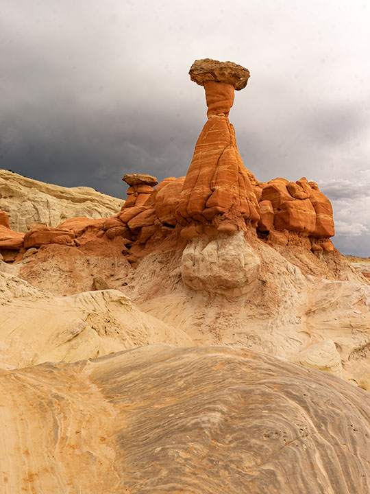
This week’s featured image only required a jone-mile hike, but it involved a climb to a shelf 300 feet above the road. Once you make it, you’ll find a group of toadstools—columns of sandstone supporting a protective capstone. Although the trail up there isn’t flat, you don’t need to be an élite climber to make it. Queen Anne got far enough that she was able to watch her hero snap this photo, which filled her with so much emotion that she had to return to the car and do her nails.
Red Toadstool – A protective capstone is supported by a column of red sandstone near Kanab Utah.
I shot this toadstool from a couple of angles and after viewing the test strips back at camp, I preferred this version even though it’s smaller within the frame. The composition is stronger, and the image is uncluttered, so the formation becomes a stronger subject. The light wasn’t what I envisioned when I planned this trip, but the thunder clouds are kind-of cool. I call this image Red Toadstool and I’m pleased to start a month of Utah photos with it.
You can see a larger version of Red Toadstool on its Web Page by clicking here. I hope you enjoy viewing this week’s post and come back next week when we present another image from a different Utah site.
In the spring of 1959, my dad traded in his ’52 Ford Business Coupé for a brand new Ford station wagon. It was two-tone — white over red — with red vinyl seats, push button radio and 4-60 air conditioning — you’d roll all four windows down at 60 miles an hour for greatest effect. Neither my three sisters nor I had a clue why he bought the new car. His pride and joy was the ’56 Crown Victoria that was in the garage. We didn’t need a reason, and we didn’t care. It was new and shiny and had pretty wide white walls. As we found out later, he bought it so we could visit his uncle in California. The six of us were taking a two-week road trip from Pittsburgh to LA and back. We were the Griswolds prototype.
When my dad was behind the wheel, he focused on the destination. I don’t think the man would have stopped for a bathroom break had not one of us been whining from the back. We started out on Friday evening, and drove all night to Chicago, but not stopping until the next evening in Joplin. Mom may have done a stint, but we were asleep in the back.
We were on Route 66, The Mother Road. We didn’t appreciate its significance then, the TV show wouldn’t air for another year and we were too busy making truckers honk their air horns. My dad was relentless, he wouldn’t stop to see the Jackalope, the Thing, the Grand Canyon, or any of the other cool places that cost time and money. Can you imagine torturing kids like that? Signs along the road … “The Thing – 50 miles”, “The Thing – 10 miles”, 5, 4, 3, etc. At least he didn’t stop the car to kill us. Of course, that would have meant stopping the car.
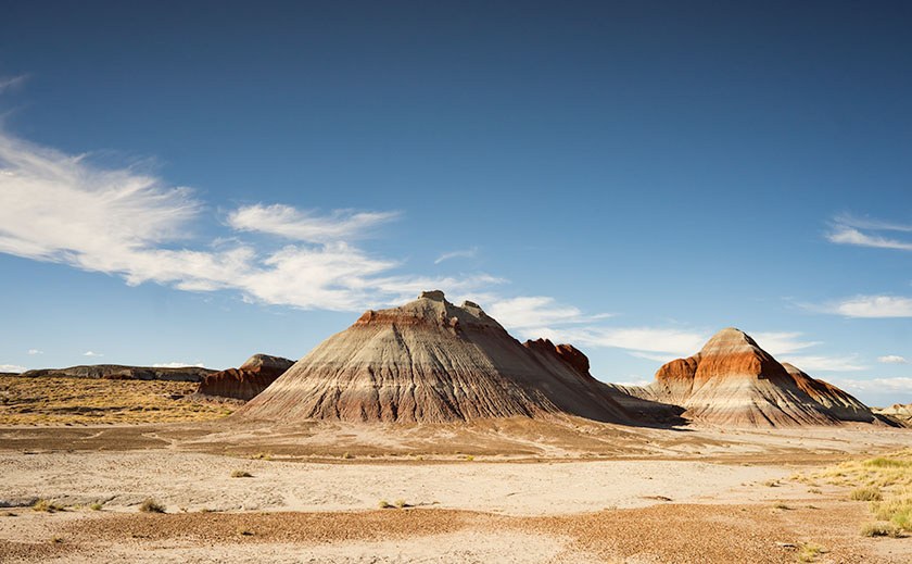
A pair of Chinle Shale formations showing the different colored layers of volcanic ash.
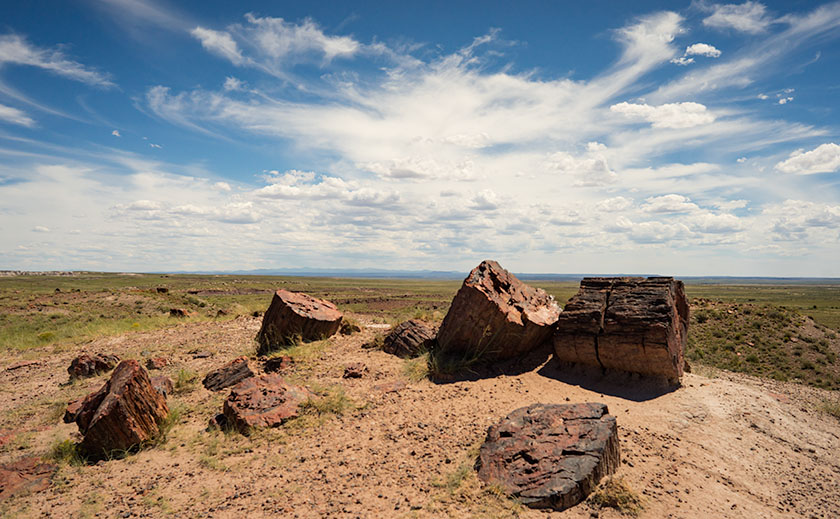
He did stop at one place — The Petrified Forest — he had to. The stupid road ran right through it. He said we could stop and go through the park and we were giddy. Finally, we’d see something and maybe get a break from the treeless desert we drove through. A forest, with trees; made from rocks … yeah! Imagine our shock when we saw all the rock-trees were knocked over. This wasn’t a respite from the desert, this was just more desert … with cool looking rocks. “There’s so many of them, can I take just one mom … huh? … huh? … Can I?” Even now, I sound so annoying, I want to slap myself.
The stops along the park road show off the park’s best. This is the Large Trees exhibit.
Within a month of our return from that vacation, my parents sold our Monroeville house and the second car. They got rid of most of our excess baggage and we moved to California. We settled into a Sylmar rental house so quickly that none of us kids missed a day of school. Although our family drove along Route 66 four more times, we never again stopped at the Petrified Forest. After I moved to Arizona decades later, I made two photography outings to the park on my own.
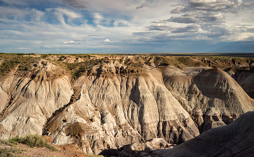
My favorite part of the park is Blue Mesa with its maze of Chinle Shale erosion.
Yesterday, I took Queen Anne to visit the park for her first visit. Despite what Google Maps says, it’s only an hour trip along U.S. Route 180. The road follows the Little Colorado as the river descends from the grass-covered Springerville Volcanic Fields, past the little town of Saint Johns where the cinder cones give way to dirty tan sandstone. The red silt river played hide and seek, only revealing itself when it passed under the empty highway. As the elevation continued to drop, the sandstone formed low tables and — where water eroded the softer underlying shale — large angular blocks broke off and slumped on the red soil below. Further along, I saw a bright white swell that I guessed was Chinle Shale and I knew we were almost there.
When we visit a national park, we head straight to the visitor center. That’s where you learn stuff … besides, I love those giant relief maps — which they didn’t have here. This time, we sat through the documentary film, browsed the museum exhibits, picked up some pamphlets, and bought two photo books before driving north along the road. As a photographer, I want to see the ‘long-shot’ first, so we slowly drove the road’s length. I made mental notes as we went, and tried to figure out how I’d shoot those images after the crowd thinned. After we turned around, we stopped at each pull-out, walked the trails, and photographed what we saw. As the day passed, I watched how the light and the sky changed as clouds formed over the White Mountains and the San Francisco Peaks before they drifted away in the invisible air stream.
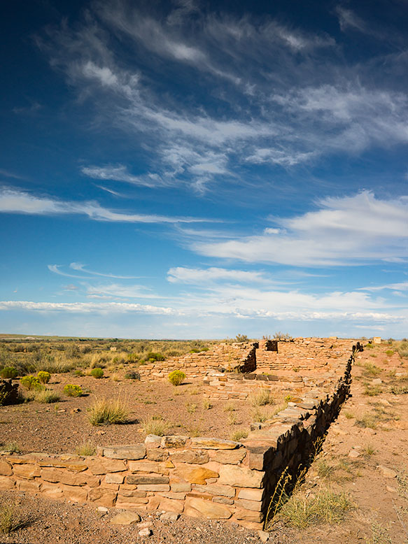
Along the bank of the Puerco River, a Pueblo ruin can be explored at leisure.
We discovered that the park isn’t just about petrified trees, it’s about layers. There are layers of soil and rocks, layers of flora and fauna, and layers of settlers and travelers for everyone to see in an open time capsule. As each rainy season washes away soil, more fossils are uncovered. There are fossils of ferns, grasses, lizards, crocodiles, toads, dinosaurs … and yes, trees. People before us settled this land, and they’ve left things behind for us to find. They left arrowheads, baskets, weaving, petroglyphs, and along the bank of the Puerco River, a pueblo ruin. Other people have traveled through the park. The Mogollon’s had trade routes to and from the Pueblos in New Mexico. In 1853, Lt. Amiel Weeks Whipple used those trails to survey the route now used by Burlington Northern Santa Fé Railroad. The tracks were a basis for U.S. Route 66 and now Interstate 40. These routes are layer upon layer of traders and countless migrants moving across the Colorado Plateau.
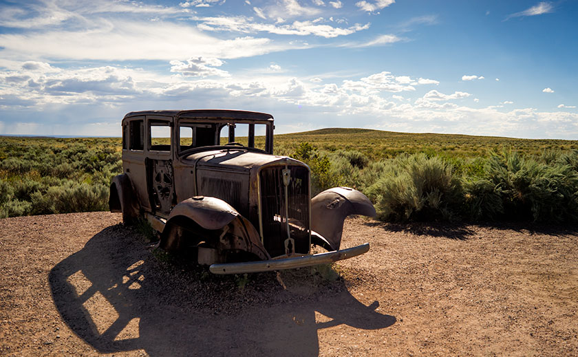
To commemorate the famous highway, the park service placed a 1932 Studebaker shell at the place where the highway and park road crossed.
Even though the National Park’s mission is to preserve and protect natural history, I was pleasantly surprised to see a nod to history more recent. There’s a turn-out north of the Interstate 40 bridge marked by a rusty skeleton of a 1932 Studebaker on blocks. It’s the spot where Route 66 passed through the park. The pavement has returned to grass and sage, and only the telephone poles give away the road’s alignment. The road of my past. While I was photographing the scene, I swore I heard distant echoes of four kids in a red and white station wagon, begging dad to stop.
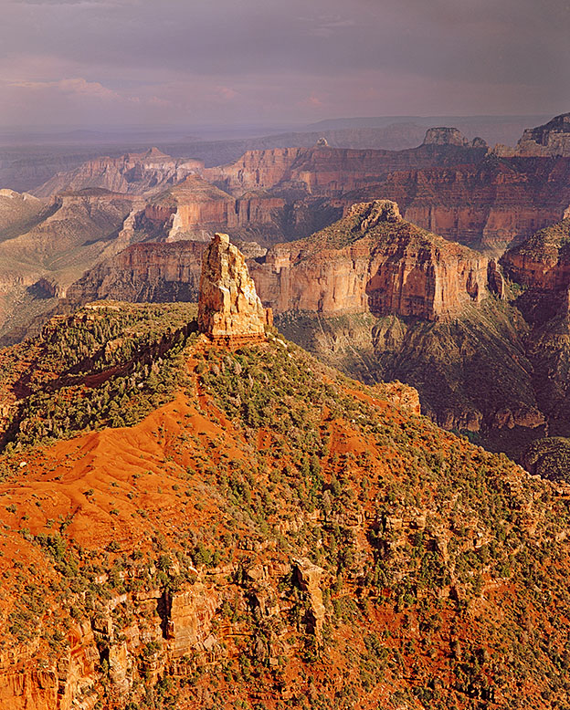
I’m pleased to announce that my premier print Mt. Hayden is on display in the lobby of Wickenburg’s branch of the National Bank of Arizona. At 24 x 30 inches, it’s the largest framed print in my collection. It’s also notable because it’s entirely analog. That’s right, it was shot on film and printed the old fashion way; in a darkroom.
Taken from the Grand Canyon’s North Rim, Mt. Hayden, at over 8000 feet in elevation, is one of the most recognizable canyon subjects.
I’d be pleased if you’d stop by National Bank and tell the folks that you came to see the Mt. Hayden print. The bank is at 540 West Wickenburg Way; just west of the railroad bridge, and they’re open normal banking hours. The print will remain on display until September 1st. Just for fun, ask if you get a free toaster with a new account.
After blowing all our money last year on the Alaska trip, Deb and I thought we were doomed to learning new survival skills for staying all summer in hot Arizona. Then our neighbor, Tom Beavert saved us. He spent his last five summers in cool Durango, Colorado and told us about jobs as camp hosts at the Lightner Creek Campground, so we checked in to it, and got the jobs.
We arrived in the middle of May, just in time for a little snow storm. This was a pleasant surprise after leaving AZ where it was already getting into the 90s. The campground is in a box canyon at 7000 feet elevation. That means the mornings are always cool (40s) and the afternoons are not that bad either (70s or 80s). We work 3 days on and 3 days off, so we have plenty sight-seeing time. It’s really nice staying here for the summer.
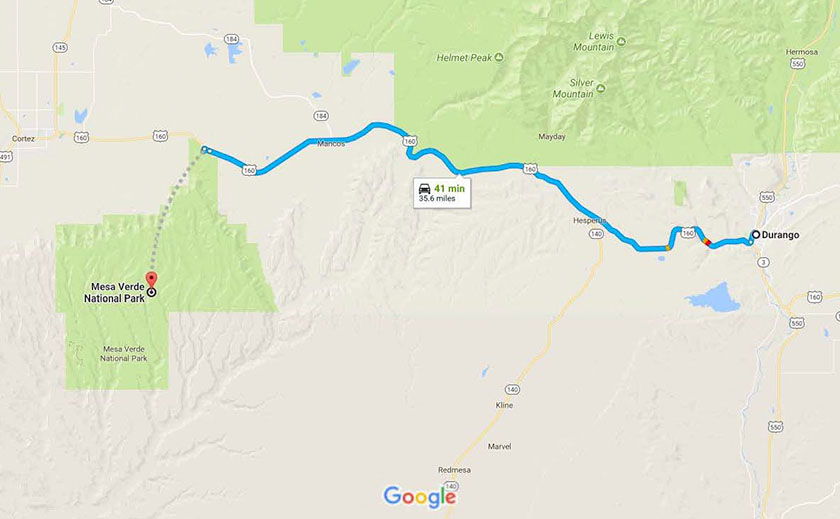
The map shows the highway between Durango, Colorado and Mesa Verde National Park.
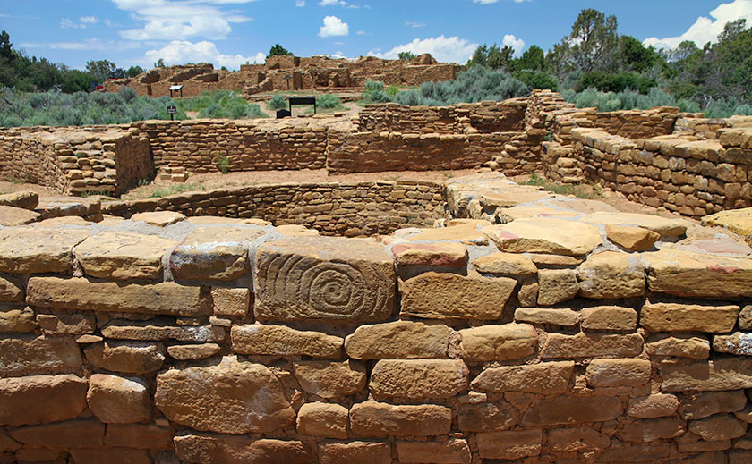
Our first outing was to Mesa Verde National Park, about 35 miles west of Durango. We wanted to visit it before the hot summer set it. When we were dating, Deb and I had stayed in Cortez, CO and had stopped at the park, but only briefly. Hmm . . . I guess we had other things on our mind back then. This time as an old married couple, we saw everything. We spent 4 days in the park and took all the tours. There are a few self-guided tours and plenty of to do on your own, but the best ruins are only accessible via $5.00 guided tours, and because the tours fill quickly, you need to sign up early.
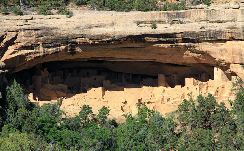
Cliff Palace, the crown jewel of Mesa Verde National Park and an architectural masterpiece by any standard, Cliff Palace is the largest cliff dwelling in North America.
Chapin Mesa is the main visitor center. It’s here you’ll find The Archaeological Museum, Cliff Palace (the largest cliff dwelling), Spruce Tree House, and Balcony House. The tours of Cliff Palace and Balcony House are a must. Balcony House is the most challenging tour. It starts with a climb up a 32 ft. ladder and ends with a crawl through a 12 ft. tunnel on your hands and knees. Believe me; it’s worth it. Allow a day to take both of these tours.
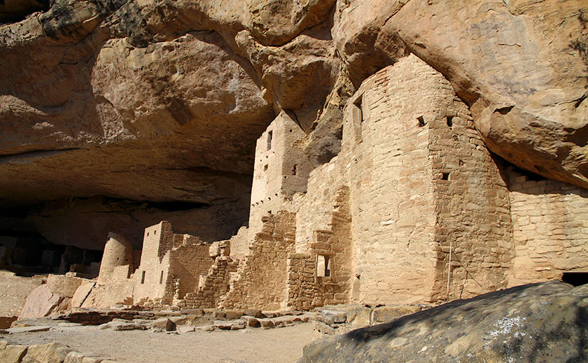
Long House, about equal in size to Cliff Palace, fills an expansive 298-foot-long sandstone alcove from end to end. The village includes about 150 rooms, 21 kivas, and a row of upper storage rooms.
Wetherill Mesa is the “quieter side” of Mesa Verde. It offers a number of opportunities, depending on the season. Mesa Verde is one of the few National Parks that allow bicycling, and on Wetherill Mesa there is a 5 mile loop built for a shuttle bus. The bus was discontinued, so now you can walk or ride your bike on a nice paved road. Wetherill Mesa was my favorite because it was less crowded and had one of the best tours.
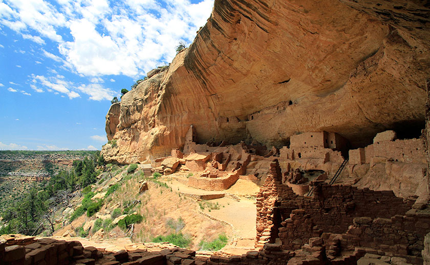
Square Tower House, a beautiful cliff dwelling built-in an alcove in the upper walls of Navajo Canyon. The “tower” had windows, doorways, and flooring, and the inner walls were plastered. About 60 of the original 80 rooms remain.
The Longhouse (the second largest cliff dwelling) tour takes 2 hours and you really get to explore all of it. Step House and Badger House are self-guided tours and you can ride your bike through the Badger House Community Trail. Allow one to two days to see everything on Wetherill Mesa.
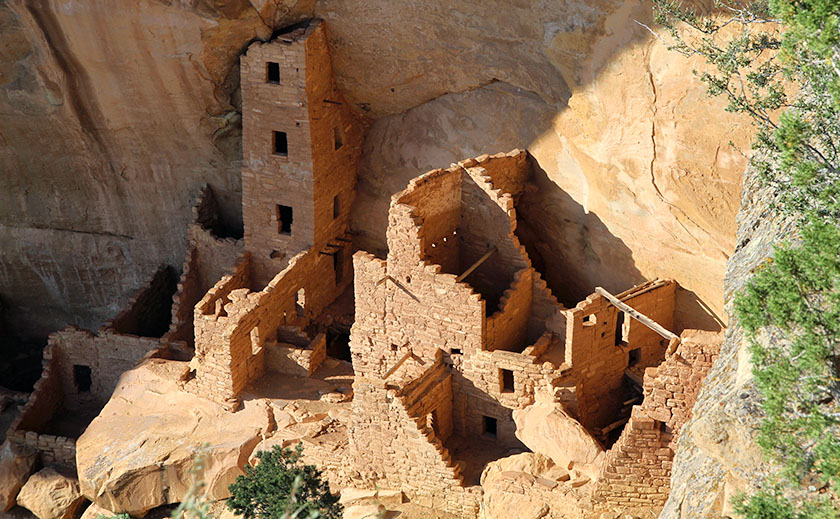
Long House, a well-preserved four-story triangular tower rises from floor to ceiling at the far west end of the alcove.
Here is a tip for grabbing a good lunch. Far View Terrace is a nice cafeteria with a gift shop run by the Ute Indians. Their prices are good and the gift shop has a better choice than the Visitor Center. The only other place to eat on Chapin Mesa is Spruce Tree Terrace, near the museum. They are both good, but Far View Terrace is much larger and quieter. We had a wonderful Navajo Taco. If you are going to Wetherill Mesa, they only have a snack bar and a covered patio where you can eat your own lunch.
Far View was a popular place in the early days at Mesa Verde. From A.D. 900 to about 1300, it was one of the most densely populated parts of the mesa. Far View House in the background and Pipe Shrine House were part of the Far View Community.
Don’t forget to pickup the Amateur Photographer’s Guide at the Visitors Center. It is just one sheet, but it has some pretty good advice. It identifies the most photographed areas, the light at different times of day, and suggested locations for shooting. You need a telephoto lens for some overlook locations, but don’t wait for sundown to shoot from the overlooks. The best time is from 5:00 to 6:30 pm to get the most light on the cliff dwellings. Note that high contrast will overexpose parts of your picture and underexpose others. It is best to zoom in on either a dark or light area.
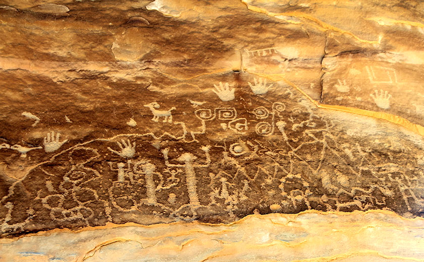
Petroglyph Point Trail, An ancient loop trail starting at the Chapin Mesa Archaeological Museum leads to a petroglyph panel and through scenic wildlife habitat. Hikers must register at the trailhead or museum. The trail is physically challenging and is steep and uneven, with steps, cliff edges and tight passages, and includes strenuousness elevation changes.
We really enjoyed Mesa Verde and now it’s time to move on to our next adventure. We will be exploring downtown Durango and its surrounding area.