Kirkland Junction Picture of the Week

A couple of decades ago, there was a TV ad where a sleepy-eyed baker got out of bed and made his way to his Dunkin Donuts store, and as he made his way, he mumbled, “Time to Make the Doughnuts.” I felt sorry for the poor guy and wished he could crawl back in bed. But, if your business is selling coffee and deep-fried cake to a morning crowd, you gotta’ make some product. You’ve got to work your schedule.

In photography, the quality of light is vital for making memorable images. Pictures that stand apart from the millions posted daily on Instagram. This topic is one that I’ve covered in my writings several times. Any subject looks better when you capture it when the light is warmer, and the shadows are longer—known as the golden hours. Those happen after sunrise when healthy people are still in bed, and before sunset when smart people have sunset cocktails. When I go out on a photo shoot, I try to time my sessions using that light.

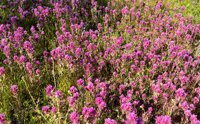
The light is even more complicated in Arizona. Because we live in a longitude closer to the equator, that golden hour dramatically shrinks in summers. To further complicate things,  the desert afternoons are too hot for scouting subjects. That’s why I chose the early morning when Fred and I went to Placerita. To get there at the right time, we left before sunrise. Unfortunately, by the time we arrived, the clouds moved in and took away the color, so I made a second trip last week. This time I was on my own because Fred was nursing an old war wound, and Queen Anne doesn’t get out of bed unless there’s a jewelry store involved.

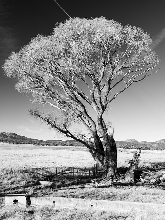
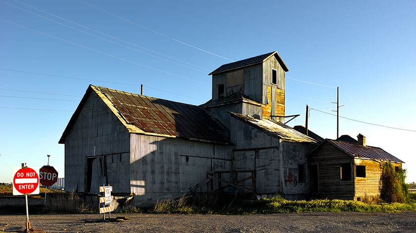
So, in the darkness, I packed my gear into Archie and drove north on State Route 89 with a USB stick full of fresh tunes and a hot mug of coffee in the cupholder. In Yarnell, the sky was bright with a line of clouds leftover from the day before. I watched the color deepen as I passed through Peeples Valley. By the time I arrived at Kirkland Junction, I had to stop so that I could get a shot. After turning onto Wagoner Road—this month’s back road—there was enough light to show color on the ground. I lined up the scene so that some abandoned structures were under the pink clouds.

A set of abandoned buildings at Kirkland Junction underneath beautiful pink clouds.
This week’s photo is of a set of abandoned buildings at Kirkland Junction underneath beautiful pink clouds. The mountain in the background is Kirkland Peak.

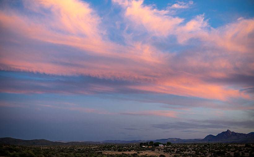
That’s how I took the last photo in June’s series. I call this week’s featured image, Kirkland Junction. Interestingly, this month we showed the subject of this month’s journey from the end to the beginning. We began the month at our destination—Placerita-and worked to the road’s start. It’s like that movie Momento.  You knew the protagonist was guilty of the murder right up to the story’s beginning that was at the film’s end. I was so confused by the time the movie was over; I had to think about it for weeks. I hope that I haven’t done that for you.

You can see a larger version of Kirkland Junction on its Web Page by clicking here. I hope you enjoy it. Next week, we’ll begin a new journey on a different, less-traveled highway. I hope you’ll join our expedition.

Until next time — jw

Boundary Cone Picture of the Week

Traveling west from Oatman, on the old Route 66, it’s only a couple of miles before the Black Mountains fill the rearview mirror. The Mohave Valley sprawls beyond the truck hood, and the road descends the talus slope to the river. There aren’t any signs here, but the beautiful view takes in three states. Arizona stops at the river, of course, but beyond the blue water, California is on the truck’s south side while Nevada is to the right.

The highway passes a rounded cone that resembles the hat style worn by the Seven Dwarves. The road has a fork here, and if your destination is Bullhead City, then go straight. But, the left fork is our historic road, and it leads south to the freeway and railroad bridges at Topock Marsh. We’re not done with the mountains yet because—for most of the way— the Warm Springs Wilderness is outside of the driver’s side window.

The Black Mountains in Mohave Country always delight me. There’s a lot in them to photograph. I understand why chunks of them have been set aside as wilderness areas. I could spend years exploring and capturing their beauty on film. As an aging dotard, however, I need my truck to do that. I’m intrigued about the new riding drones that police departments are buying. They look like a motorcycle with four propellers strapped to the sides (like in this Dubai video). One of you needs to come up with the money to buy me one. With my luck, however, I’d fall off into one of the blades and become sliced salami. Besides, the government doesn’t allow drones in wilderness areas (national parks, wildlife preserves, or recreation areas). What’s that old saying? “I would have taken better care of myself if I knew that I was going to live this long.” Why did we ever laugh at Jack LaLanne?

Boundary Cone - On the right is Boundary Cone, the center of the Mohave Tribe's world, and a handy marker to keep you dry.
Boundary Cone – On the right is Boundary Cone, the center of the Mohave Tribe’s world, and a handy marker to keep you dry.

This week’s featured image was a call at the line—sorry for the sports metaphor. I had another picture picked out, and already published, but when I started researching the area, the image that I call Boundary Cone has a better story. The 4000’ peak sticks out like a sore thumb from anywhere in the valley. The Mohave Indians consider it sacred, and it is the center of their homeland. Imagine how upset they were when miners started digging at it.

Coincidently, if you could walk from Boundary Cone due west to the middle of the Colorado River, and then north for a couple of hundred yards, you would be standing—or swimming—in Arizona, California, and Nevada at the same time. Just like people do at Four Corners, and nobody would charge you (I sincerely think people would pay to see that). The actual point where the three states meet is the intersection of the 35th parallel and the Colorado River. But, I think it’s cool that you can tell which state you’re in by glancing at Boundary Cone without getting wet.

You can see a larger version of Boundary Cone on its Web Page by clicking here. I hope you enjoy it. Next week, we’ll continue our Route 66 journey to the freeway. I hope you’ll join us then.

Until next time — jw

White Bluff Picture of the Week

For most of the 1200 miles between Oklahoma City and Barstow, Route 66 and Interstate 40 are stuck together like a zipper. As you drive along the freeway—started in 1957 and completed in 1984—you can see a ghost of the old mother road on the roadside. Sometimes it’s a frontage road with little traffic, in different spots the pavement is gone, and it’s not a road at all.

Arizona has two exceptions to these overlying trails. The first is where Interstate 40 cuts off Peach Springs between Kingman and Seligman, and the second is between Kingman and Needles. In the first case, the freeway cuts miles off the trip by heading straight across country, while the latter deviation is further (albeit quicker) as it skirts the Black Mountain Range.

The section of the historic road that Queen Anne and I explored this month cuts through a mountain pass that Captain Lorenzo Sitgreaves mapped in 1851. Although the trail has beautiful scenery for me to photograph, it is very twisty and slow going, and that’s not ideal for interstate commerce.

Cool Springs Station - A historic gas station converted to a gift shop that now sells hot dogs from a cart.
Cool Springs Station – A historic gas station converted to a gift shop that now sells hot dogs from a cart.

After we finished photographing Thimble Mountain seen in last week’s post, we continued along the road for less than a mile, where we stopped at an old gas station called Cold Springs. The owners have converted it into a gift shop that sells nostalgic Route 66 kitsch, but there were no customers. As I snapped a few pictures, a woman’s voice came from the shadows, “Hello there. How ya doin’?” When I took off my sunglasses, I saw a young woman sitting in the shade next to a hot dog cart. We made small talk, and I asked about her business. “April is normally our best month, but this year it’s a bust.” After promising not to include her in my photos, I took another shot or two before we drove away. Looking back, we should have bought our dinner there. She could have used the money, and her food was probably better than the drive-through meal we got at the Kingman Carl’s Jr.

As we drove further, we had to stop almost immediately again, where the canyon narrowed. On the road’s north side was a pair of sandstone bluffs rising from the dry creek bed. Their cliffs glowed in the late afternoon sun, so of course, I had to capture the moment on film … er, I mean electrons. I’ve since found out that at this location, the road passes between two wilderness areas. To the north is the Mt. Nutt Wilderness, while on the road’s south side is the Warm Springs Wilderness area.

White Bluff - The vertical sandstone cliff of a bluff provide a great home to nesting swallows.
White Bluff – The vertical sandstone cliff of a bluff provides a great home to nesting swallows.

In this week’s featured image—called White Bluff—you can see Mt. Nutt in the distance. At over 5100 feet it is the tallest peak in the Black Mountain Range. To get any closer, you’ll have to hike or grab one of the local wild burros—of which there are many—and ride.

You can see a larger version of White Bluff Butte on its Web Page by clicking here. I hope you enjoy it. Next week, we’ll travel over the pass and make a stop in Oatman. I hope you’ll join us then.

Until next time — jw

Hassayampa Clover Picture of the Week

The signs of spring are everywhere here in the Sonoran Desert. Blue lupine, orange mallow, and yellow brittlebush carpet the roadsides. In another couple of weeks, our desert trees will renew their green foliage, and yellow flowers cover the palo verde trees. When the air is still, I can catch a whiff of the neighbor’s citrus trees, which is catnip for me. We’ve had weekly low fronts move through, keeping the temperatures fresh and the mountains wet. However, in between the cloudy days, the air is warm and bright, so it’s time to throw open the doors and windows and let in the allergens.

I have a terrible case of spring-fever, hay-fever, and a toothache, none of which I can do anything about right now. Each spring, Queen Anne and I usually jump into the car for a weekend road trip. This year—like all of you—we’re stuck at home binge-watching The Tiger King (we finished Netflix). I’ve spent the weekend napping all day, and my sinuses are acting up. I know that the pollens are causing it because this happens every year, and I’m not running a fever. I’m so paranoid because of the pandemic, it makes me question if I’ve caught the virus, and I have panic attacks until Anne slaps my face and yells, “Get over it.” I think she gets into it because she’s whacked me hard and often enough that I need to visit my dentist about a loose tooth—but the government has closed the border.

Hassayampa Clover - Purple Owl's Clover carpet the desert floor near the Hassayampa River Box Canyon.
Hassayampa Clover – Purple Owl’s Clover carpets the desert floor near the Hassayampa River Box Canyon.

After I calm down, I retreat into my office and work on the pictures I shot for you, like this week’s image called Hassayampa Clover. It’s one of the photos that I captured on our clandestine outing last week. It’s another view of purple owl’s clover, but in this case, I’ve included the surroundings near the Hassayampa River (which loosely translates into the upside-down river).

The bare hackberry and mesquite among the purple carpet are a giveaway that its early springtime. As the days warm, all of the plants sprout and obscure the landscape. You really can’t see the desert through the brush. The desert stays pretty like that until summer when they’ll drop their leaves again to survive the heat.

Doesn’t the scene make you want to kick off your shoes and skip through the clover? You’d be sorry. The ground is full of sharp rocks, cactus needles, cow pies, ants, scorpions, and the snakes are active already. You’re better off to enjoy the view from your computer screen and let me do all of the dangerous work.

You can see a larger version of Hassayampa Clover on its Web Page by clicking here. I hope you enjoy it. Come back next week when we continue with our illicit trip to Wickenburg’s Scenic Loop.

Until next time — jw

Purple Owl’s Clover Picture of the Week

I’m amazed at how much things have changed in a month, and how current events are forcing me to find new ways to provide new content for you. Last month was Anne’s knee surgery, where I needed to stay close to home and care for her. Now that she’s on the mend, I thought I’d be able to go on one of my road trips and gather new subject matter, but that’s not happening. With the pandemic looming over us, our Governor has ordered us to “Stay At Home” unless it’s for essential services. His list of critical activities includes playing golf—as a form of exercise.

Those of you that know me well know that I’m not a rebel. I’m no James Dean, and I usually follow the rules. In other words, I’m a coward. I’ve spent the last week anxiously trying to figure a way to get new photographs for you. Should I go on my planned trip? Should I cancel my blog this month? My stomach was in knots, and I wasn’t sleeping well. I was only getting two naps a day instead of my usual three.

I spent the beginning of the week perusing the Governor’s proclamation, and I came up with an answer. Instead of taking a trip out of town, I’d pick an empty road in Wickenburg. That way, if the Gendarmes stopped us, I could say that we’d gotten lost on the way to the golf course, and we were only exercising.

The road we picked is called The Scenic Loop—seriously, that’s its name. It starts at US 93 north of town and goes past the Hassayampa River Box Canyon before it winds up at the Boyd Ranch. We had no problem keeping a safe distance from other people because we were alone. In the two hours we photographed, I got enough material to keep me locked in my office until June.

Another big difference is the contrast between March’s pictures and those I have for April. Last month was about winter and old gnarly cottonwood trees. This month’s series is about spring, color, and new growth. April is always the prettiest time to be in the Sonoran Desert.

Purple Owl's Clover - In the years when the winter is wet, the desert gets painted with wildflowers in spring.
Purple Owl’s Clover – In the years when the winter is wet, the desert gets painted with wildflowers in spring.

This week’s featured image is an example of what I mean. Usually, the desert floor between cacti is bare gravel, but not this week. It’s full of grass and wildflowers, and in this case, a patch of Purple Owl’s Clover. I don’t think it’s related to the tiny white flowers that get into your lawn; they just look the same. Patches such as these appear on flats where there’s Goldilocks water (just right).

You can see a larger version of Purple Owl’s Clover on its Web Page by clicking here. I hope you enjoy it. Come back next week when we continue with our illicit trip along Wickenburg’s Scenic Loop.

Until next time — jw

Peeples Valley Cottonwood Picture of the Week

Four years ago, when Queen Anne and I moved to Congress, one of the decisions we made was to cut-the-cable. Well, it wasn’t a hard decision to make because Cox doesn’t cover this area, and we were tired of paying Dish Network more than a hundred bucks a month. Fortunately, we’re in line-of-sight with the South Mountain antennas, so we get the major local channels sharper than a cable signal. To supplement our viewing choices, we bought a TIVO box and signed up for the fastest Internet available in our neck of the woods, and we get the gist of current shows via YouTube.

One of the channels we repeatedly watch is The Daily Show with Trevor Noah. It’s a comedy-news show that we’ve enjoyed since Jon Stewart was the host, and Trevor has carried on well. Last week, or maybe it was the week before, he had a segment titled Is This the Way We Die? – Coronavirus. For Anne and I, that question struck close to home.

I usually shy away from writing about current events—I don’t know why, because I can’t count the number of times that people have called me an opinionated jerk—but, this week, I feel like talking about the elephant in the corner. I know that most of us will catch this bug and shrug it off in a couple of weeks. However, there’s that small percentage of elderly with underlying health issues that are at risk. With my diabetes and Anne’s recent surgery, we are that group. So it got my full attention. I’ve been preoccupied lately with my mortality, and asking myself, “Is this how it all ends?” I’ve concluded that I haven’t run out of film yet, and we’re going to carry on. I always knew that there was an upside in being an anti-social curmudgeon, and my time has finally come. I’ve practiced Social-Distancing for years, so I pretty much have it down pat. Now, if I could get one of you to throw a pack of toilet paper up on the porch now and again, we’ll be fine.

To maintain your sanity, the doctors recommend that you get out of the house and exercise. Walk around your block, ride a bicycle, or just spend some time outside, but stay away from crowds. I’m glad they urged that because it means I can still go out and shoot photographs. With my kind of subjects, I don’t interact with other people so that I won’t harm them or myself, and that brings me to this week’s featured image.

Peeples Valley Cottonwood - An old cottonwood tree growing along a rancher's irrigation line.
Peeples Valley Cottonwood – An old cottonwood tree growing along a rancher’s irrigation line.

This picture is my fourth image in the series of Peeples Valley Cottonwood trees, and this one is called Peeples Valley Cottonwood. It’s an old cottonwood tree growing along a rancher’s irrigation trench. In case you didn’t recognize it, it’s the same tree that is the subject of the first in this series—Broken Cottonwood. The angle is slightly different, and I used a polarizing filter to darken the sky. I think it gives the tree a three-dimensional look.

You can see a larger version of Peeples Valley Cottonwood on its Web Page by clicking here. I hope you like it. Be sure to come back next week for the final portrait from Peeples Valley.

Until next time — jw

p.s. I know that these are not going to be the easiest of times, but we’ll get through this. Be kind to one another and find something you enjoy doing. Listen to what the doctors say and stop obsessing on the news.

Above the Yardarm Photography Tip

Bartlett Hotel
Bartlett Hotel – The ruins of the Bartlett Hotel in Jerome. Summertime shooting in the southwest deserts means being ready when the light comes in.

Spring is ending and there are signs of its imminent demise everywhere. This year’s crop of quail chicks, which looked like gray dust bunnies a few weeks ago, has already grown to three-quarter size. I’ve seen normally wary jackrabbits come in off the desert looking for water. Tropical storm Bud managed to bring rain throughout the valley except at the airport where the Weather Service records official measurements. It brought a welcome break from the heat and an early arrival of the summer monsoon storms. As far as I’m concerned, summer started when the thermometer exceeded the century mark several weeks ago. The Summer Solstice is tomorrow—the official start of summer and the longest day of the year. You’d think that all this extra daylight would be better for picture-taking. Not in the Sonoran Desert—not for me.

As an art-photographer, I consider myself average at best. The reason is partly that I’m not that creative and I’m too lazy to really work hard at it, and partly because I work too fast. I’m comfortable knowing this, but to compensate I use every advantage I can. I use high megapixel cameras so I have lots of margins when editing. I print on high-quality paper and mat to museum standards so my product has lasting value. I’m learning to make my own frames to differentiate them from cheap import stuff. And finally, I only shoot when the light is best—the Golden Hour or the Blue Hour—the short period before or after the sun transits the horizon. The rest of the time, the sun is over the yardarm—the term sailors on tall ships used when it was time to go below deck and drink rum. In photography, the light has lost color. The landscape goes flat, there’s too much contrast, and—especially in the desert—there’s too much glare. Photographers say, “We’ve lost the light.”

In the desert southwest, there are still periods when the light is pleasing in spring and summer, they’re just very short. I joke when I say, “morning’s golden hour lasts 5 minutes,” but I’m not far off. I don’t have the luxury of wandering around and shooting multiple subjects; I must plan and be there when the light is right. The reason for this phenomenon—here in the desert—is the sun’s angle. Because we’re so close to having the sun directly overhead this time of the year, the light comes straight through the atmosphere and that’s when the sun’s light is the whitest. The lack of humidity here plays havoc too. In the dry air, light reflects off objects which washes out the colors. Just wear a pair of polarized sunglasses to see what I mean.

This light thing doesn’t happen globally. I’ve read internet posts, written by northern photographers, longing for the long summer days and better light. The first time I noticed a difference was when Queen Anne and I visited New Zealand. As we explored the islands, we agreed on a schedule where I could shoot in the morning then travel to a new place where I could shoot again at day’s end. I kept messing up our plans because the light was still good and I was still working at 11:00 am; something I normally wouldn’t do. I had the point really hammered home to me a couple of years ago when we were traveling through Idaho. While there, I got up before sunrise to shoot a grain elevator and as I walked to the scene, I looked for the brightest part of the sky to guess where the sun would come up. It surprised me to find that the sun didn’t rise that day—at least vertically like I’m used to—instead it slid west along the horizon for several degrees before clearing some distant trees. The light on the grain elevator was a different angle than I expected and I had to move the camera to compensate. I got my shot went back to the trailer and, before 6:00 am, I crawled back in the sack. When we packed and left later that morning, we drove by that old building and the light was still good. I could have slept in, had a cup of coffee and still got my shot.

Madison Grain Silo
Madison Grain Silo – In northern latitudes, the golden hour takes its time.

My argument can be condensed into this; the working length of good light changes with latitude during summer. It’s longer in the north and shorter here in the south (yes, in the southern hemisphere the water circles the toilet backward). It all has to do with the sun’s light angle through the atmosphere. Evidently, this isn’t a new idea because I found this neat sun-angle calculator on the Internet. It’s really slick. You put in the day and place, and the map will display the angle of sunrise and sunset. Then you can move the pointer north or south and watch as the angles change.

To get through this period of long (hot) days, I have a couple of strategies that get me by. I slow down my productivity. As I said, instead of wandering and looking for something to photograph, I’ll scout sites out. After finding a good subject, I’ll go back at a time when the light will be right. If I have all the details worked out, I’m out and back within an hour. You could call it, Hit and Run shooting. My favorite coping mechanism is to go where the light is better. If the light won’t come to you, then you go to the mountain. In Arizona, we have an old tribal word for such behavior—snowbird.

Until next time — jw