Central Commercial Picture of the Week

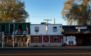
Before Interstate 40, before Route 66, and before the Railroad, Seligman was a quiet Havasupai Village where Beale’s Wagon Road crossed the Big Chino Wash, and the reason you stopped there was for water. Back then it was called Prescott Junction because you could hop on a stagecoach to the territorial capital. Not a lot of people traveled that wagon trail because it was rough, dangerous, and in the middle of the God-forsaken desert. All of that changed in 1849 when James Marshall discovered gold in California, and suddenly everybody and his brother wanted a share.

Congress immediately passed a bill to give away ridiculous chunks of land as incentives for railroad upstarts to lay tracks from coast to coast, but the Civil War got in the way. Shortly after peace broke out, the railroads got to work in earnest. In those days, you had to plan for fuel and water stops every 30 miles, and that’s the reason railroads built regularly spaced stops every 30 miles. They renamed the town Seligman for Jesse—one of the big money guys from New York. Being halfway between Flagstaff and the California border, its site was in an excellent spot for crew swaps, and since there was plenty of flat space, the company built a large switching yard here. So, Seligman became a busy stop along the route. The trains don’t stop anymore, in fact, they don’t even tap the horn as they rush by on the quarter-hour.

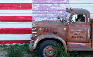
Seligman’s historic district is within walking distance of the old depot, which—unfortunately—was demolished in 2008. It had a Harvey House—like the one in Winslow—and a reading room. I would have loved to have added them to my collection, but I’m a decade late. The old section of town has several notable buildings: a garage with gas pump island, a few warehouses, a boarding home, and some overnight cabins that the train crews used.

Central Commercial
Central Commercial – the Pitts and Washington Central Commercial Department Store on Route 66 in Seligman Arizona. It needs to be restored to red brick, and gold lettering with a green awning.

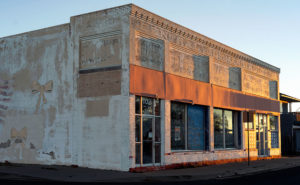
The building that I kept coming back to was this store. I immediately walked to it, because of the flag mural and yellow ribbons on the side wall. After walking around town, I returned and shot some other angles. When I got out the next morning, there it was again, and I liked how the daybreak lit the front. It shows off every brick and the fascia detail along the top. It even reveals some of the original sign hiding under the whitewash. From the tour guide that I picked up at the barber shop, this is the Pitts & Washington Central Commercial Department Store built-in 1903. The brick was probably red, and the signs were gold—like a Woolworth’s. I believe the whitewash was added later to accommodate new tenants. It’s my picture of the week, and I call it Central Commercial.

I think it would be neat to see it restored and brought back to life as a working museum. I see it stocked with period and retro items for sale. There’s not enough traffic to sustain such a free-standing business, but maybe a display center for an online store could work—sort of an Amazon for antiques. I feel the car culture that the town caters to would patronize a store that carried upscale items like that. On the other hand, maybe it’s too late because that’s my generation’s thing, and we’re fading rapidly.

You can see a larger version of Central Commercial on its Web Page by clicking here. I hope you enjoy viewing this week’s post and come back next week when we’ll show another featured image from a different place in Yavapai County.

Until next time — jw

Fire Flag Picture of the Week

When I go to a new town like Seligman, I’m like any other visitor. I take in the bright lights and displays along the main street. After all, that’s the show. The merchants want to attract you into their stores. It makes good business sense. The old maxims counsel you to, “Put your best face (foot) forward,” and “Show your better side.” They can’t make a living if no one comes in.  That’s why the storefronts are updated continuously with fresh paint, displays, and signs.

Fire Flag
Fire Flag – A retired Seligman fire truck sits along a clapboard store.

But sometimes there’s good stuff out back, and that’s why I walk a new town’s back streets and alleys. They aren’t all spit-polished, and you can see a building’s structure untouched since it was new. If you’re looking for history or art, an alley is more rewarding because merchants ignore it.

That’s how I found the subject for this week’s featured image. It wasn’t behind but along a clapboard-sided store. It has a big faded hand-painted flag and retired fire truck which could be a museum display. The mural alone was a good shot as was the fire engine, but I decided to go for a twofer. The block of purple is a mystery, but it works in the photo. I named this image Fire Flag because it was a short, catchy description of the image.

You can see a larger version of Fire Flag on its Web Page by clicking here. I hope you enjoy viewing this week’s post and come back next week when we’ll show another featured image from Seligman and Route 66.

Until next time — jw

Rusty Bolt Picture of the Week

♬ Get your kicks ♪
On Interstate 40 ♫

Well, that didn’t work; it’s not musical and doesn’t even rhyme. I suppose I shouldn’t try to mess with Bobby Troup’s song. I haven’t any musical talent anyway. My grandmother repeatedly told me, “You couldn’t carry a tune in a bushel basket.” The only thing I can play is the radio … while I’m driving, and when I drive across northern Arizona, that 1946 song inevitably pops into my head. Everybody from Bing Crosby, Chuck Berry, to the Cramps, have recorded it, so the tune has legs.

Rusty Bolt
Rusty Bolt-The Rusty Bolt drags bus-loads of tourists into the saloon to try their signature cocktail-a Rusty Bolt. I assume it’s a Rusty Nail in a bigger glass.

The reason that song has become an earworm in my brain is that Queen Anne and I drove two and a half hours to Seligman for this month’s photo shoot and we never left Yavapai County. For fifty miles, Route 66 runs along the northern border of our county—from Yampai to Ash Fork—and Seligman is at the west end of the most extended active section.

I’ve already recalled some of my personal experiences traveling cross-country on US 66, so I don’t want to be your grandpa continually retelling the same stories. But for the next generations, I’ll summarize some of the road’s highlights. Completed in 1926, U.S. Route 66 was one of the first paved highways across the west. It ran from Chicago to Santa Monica and provided an economical alternative to train travel. It was known as the Will Rodgers Highway, Main Street America, and the Mother Road. During the Dust Bowl and Depression era, thousands of migrants traveled west on the highway in search of a new life, a story that John Steinbeck captured in his epic novel Grapes of Wrath. My generation grew up watching Route 66 on a black and white 17” TV. The show’s two male characters—Martin Milner and George Maharis—traveled across the country in a Corvette. Their travels involved but weren’t limited to 66, and no one questioned their sexual orientation back then. The show turned the highway into a symbol of escape and adventure and permanently linked the Corvette to Route 66. (Incidentally, the show’s theme song made Billboard’s top 30 list.) The building of the Interstate System killed Route 66. The freeways went around towns and eliminated stop lights and speed traps. Without Federal money, states abandoned the road and began digging it up.

Angie's Chair
Angie’s Chair – Angie (cardboard cutout) and his wife-Vilma-founded the Route 66 revival movement from his Seligman barber shop and pool hall. I wanted to get my hair cut, but he was home sick with the flu.

In 1978 when Interstate 40 opened and bypassed Seligman, the town’s commerce disappeared, and that put the town’s existence in jeopardy. But the town’s barber administered CPR. Angel Delgadillo met with representatives from other affected communities, and they formed an organization to turn things around. They worked to make the old US 66 a Historic Highway. Within a year, the association successfully lobbied the Arizona State Government to declare the section between Kingman and Seligman a Historic Highway, with parts from Ash Fork to California added later. After that, other states followed our example, and they tagged sections of the remaining road as historic.

The nostalgia caught on, and soon gift shops were selling Route 66 kitsch and memorabilia. Each year, the Historic Route 66 Association organizes a Fun Run. On the first weekend in May over 800 cars gather in Seligman for a car show in the morning before driving en masse to Kingman for the night. The next day, they continue to Needles. Most of the participants are of my generation and are driving cars they wish they had in high school. 2019’s annual run will be the 32nd year.

On our Seligman visit, we saw several businesses competing for customers by displaying memorabilia and vintage cars out front. Of the samples we saw, this one stood out. It’s the Rusty Bolt Saloon and—along with the signs and flags—they added mannequins to their building. I’ll tell you that when you drive by, you think there’s a wild party going on here. I took this shot early in the morning as the sun came up and I liked how the statues stood out in the sun. The other advantage to shooting that early is the lack of tour buses parked along the sidewalk.

You can see a larger version of Rusty Bolt on its Web Page by clicking here. I hope you enjoy viewing this week’s post and come back next week when we return to Seligman and more photos.

Until next time — jw

Out Buildings Picture of the Week

Any discussion about Black Canyon City wouldn’t be complete without mentioning Rock Springs, so I saved that for last this month. It’s hard for me to know where to begin. If you say that name, most Phoenicians will think about the pie restaurant. It’s understandable, it’s been open for a century now, and every time we drive by and think about stopping, we don’t because it’s packed. Like Yogi Berra said,” Nobody goes there anymore, because it’s too crowded.” As for lasting 100 years, I’d like to extend my congratulations, but I don’t want to talk about pies, I want to discuss its history.

Out Buildings
Out Buildings – A pair of tin roofs on storage sheds behind the Rock Springs Cafe.

Before cars, trains or airplanes—when I was a child—travelers stopped at Rock Springs because it was a reliable source of good water. People came here for centuries before Caucasians lived in Arizona. On your next visit, take the time to stroll around the grounds and look for the Waterfall signs. Outback, you’ll see water drizzling over polished and worn boulders—that’s Rock Springs. The restaurant has a couple of tables out there so you can enjoy a waterside cocktail. I imagine that the flow over the falls is pretty good at times, but when it’s dry, it’s more like forgetting to turn off your garden hose.

The water is the reason that Ben Warner opened a tent-like store, and—in 1918—built a hotel on this site. In case you didn’t notice,  I love these historical buildings. Fortunately, the café has a Web Page that speaks of its history and shows an old photo of the block building—with an A-1 Beer sign hanging from the portico. I really wanted to capture an image of that hotel and talk about some of its famous guests; like Jean Harlow, Tom Mix, and Wyatt Earp. I couldn’t. Decades of hastily planned expansions have camouflaged the original building. Only hints of the original hotel sick out here and there. After circling the restaurant as the sun rose, I gave up and shot other subjects.

On one of my laps, I saw this interesting pattern of weathered tin roofs on a couple of storage sheds behind the Rock Creek Café. It’s as if they knew that I would be shooting this because they built a simple plank fence that masks the clutter and adds a perspective line to the scene. When I took this shot, I honestly didn’t pay attention to the clouds, but let’s not tell anyone. I’ll claim that I planned it. I call this week’s image: Out Buildings.

You can see a larger version of Out Buildings on its Web Page by clicking here. I hope you enjoy viewing this week’s post and come back next week when we begin a new monthly series from a different place in Yavapai County.

Until next time — jw

Swilling Cabin Window Picture of the Week

This week’s story has all the ingredients of a great Hollywood western movie: plantations, young love, war, drugs and alcohol, heartbreak, gold, bright futures, despair, stage robbery, friendship, false accusations, and tragic death. I don’t know how I can tell it all in 500 words and still explain my weekly photograph by the third paragraph. I’ve found several books and articles about Jack Swilling, but there haven’t been any films. That’s a shame because I can visualize told in the fashion of the Steve McQueen movie Tom Horn.

Swilling Cabin Window
Swilling Cabin Window – Jack and Trinidad’s cabin ruins in Black Canyon City are on private property, and its caring owners are its only protection.

Every school kid in Phoenix knows how Jack Swilling—or one of his friends and crew, Phillip Duppa—tossed out the mythical bird’s name for the small town they were developing. For the rest of you, Swilling filed a land claim around present-day 32nd Street and Van Buren Road. He wanted to grow hay to sell to the cavalry at Fort McDowell, so he copied the Hohokam method of using Salt River water for the fields by digging new canals to his property. The visionary Swilling (I suggest casting a 20-year-old Jeff Bridges) played an essential role in the layout and alignment of the new town. A couple of years later he lost interest when the council—or whoever decided those things back then—moved downtown three miles west to its present site. Jack threw his hand up in disgust and he and his wife, Trinidad (my casting idea would be a 17-year-old Natalie Wood), moved to Gillett—a mining ghost town three miles south of Black Canyon City.

In Gillett, they built a cabin along the stage route and provided travelers and horses food, water, and rest. It helped to supplement his paultry mining income. His health was failing from old head and bullet wounds he got as a younger man. He took morphine and drank whiskey to counter the constant pain, but now the drinking got worse. When he got word that Colonel Jacob Snively—his old Indian war buddy—was killed near Wickenburg by Apaches, Trinidad encouraged him to retrieve the body and give Jacob a proper burial. Jack enlisted the help of a couple of neighbors and rode out to recover his friend. During that same three-day period, a stagecoach was robbed—also in Wickenburg—and the robbers murdered everyone on board. After Jack returned and buried his friend, he was at the bar when he heard about the stagecoach massacre. Jack cracked a joke about how robbing the stage is the only way to make big money these days, and the vague description of the robbers could include his retrieval party. They were arrested on the spot and shipped off to Prescott for trial. Since the Feds had charged him too, the territorial government dropped their complaints to save money. The marshalls transferred Swilling to the Yuma prison where his health took a turn for the worst, and he died before his trial. Shortly after his death, the law identified and caught the real robbers. Jack was already buried in the Yuma Prison cemetery before they notified Trinidad of his death.

When I decided that October’s subject would be Black Canyon City, I did my research, and there, I discovered the cabin ruins were in town. I wanted to photograph them, but they’re not on a map. That’s because they’re on private property and not open to the public. I stopped and talked to the tourist info people, and they gave me directions to the house, and when I drove up to the residence, the owner came out and chatted with me. When her parents built her home, they bought adjoining lots so that the stacked-stone cabin could remain intact. Black Canyon City doesn’t protect historic sites as other cities do, so they took that task upon themselves. She gave me permission to roam the property and to photograph the cabin with two caveats: don’t lean on the walls—they’re fragile and will quickly crumble, and don’t take any of the artifacts she has on display. A very reasonable request, I’d say.

Of the shots I took, I liked this variation best because of the window and the light filtering through the mesquite trees. Jack’s one-room cabin may not seem like the palace that the Father of Phoenix (and Mother) should have lived in, but just examining the rock-work made my sciatica nerve go off. It’s on a quiet cul-de-sac surrounded by modern homes near the Agua Fria River. I stood for a while and listened to the breeze blowing through the tree canopy, and I could see how it might have been to live there a century and a half ago.

You can see a larger version of Swilling Cabin Window on its Web Page by clicking here. I hope you enjoy viewing this week’s post and come back next week when we’ll show another featured image from Black Canyon City. “Oh!” you say. “But Grandpa, what about the rest of the story—where are the parts about the plantation, the Mexican-American War, the Confederate Lieutenant, Peeples Valley, Rich Hill, et al.” Well, you’ll have to wait for the movie or pick up a book.

Until next time — jw

Saguaro Grove Picture of the Week

When I was roaming around Black Canyon City a couple of weeks ago, I was on a street with homes along the right side and open land on the other. On the hillside was a dense stand of saguaro growing, and I knew I wanted to capture their image, but the field had a barbed wire fence. As I drove further down the street, I found an open spot. A gravel road led onto the property, so I parked the truck and got out for a closer look.

Saguaro Grove
Saguaro Grove – these giant cacti grow exceptionally well on south-facing, well-drained slopes.

I’m usually cautious about trespassing, so I always look for Keep Out signs. After all, this is Arizona, and I’m allergic to bullets. I saw no postings nearby, but a sign was down the road. It read, “Agua Fria National Monument.” I thought, “There’s a national monument? Here, this close to Phoenix? Why don’t I know about this?” All the open areas from Black Canyon City to Cordes Lakes and east of Interstate 17 were given monument status in 2000 because the Agua Fria River is a treasure of ancient dwellings, petroglyphs, and artifacts. There are no freeway signs, visitor centers, or entrance fees. There is a hiking trail that runs its length, and you can walk, bike, or ride horseback. Bloody Basin Road cuts through the monument; from it, you can access a couple of rugged jeep trails. So, I’ve already mentally filed it away as a future project.

Meanwhile, back at Black Canyon City …

Saguaro grows exceptionally well on well-drained south-facing slopes, so when you see a grove like this, you can tell the compass direction—like moss on the north side of trees. The overhead clouds are remnants of Hurricane Rosa, which dumped enough rain to plump up these giant cacti. They look like my uncle making his way to the couch after Thanksgiving dinner. I could have titled the image with a snarky name, but I didn’t. It’s merely titled Saguaro Grove.

You can see a larger version of Saguaro Grove on its Web Page by clicking here. I hope you enjoy viewing this week’s post and return next week when we show another featured image from Black Canyon City.

Until next time — jw

Perry Mesa Needle Picture of the Week

Perry Mesa Needle
Perry Mesa Needle – This needle is at the edge of Perry Mesa above Black Canyon City. It’s new to me because it’s hidden from the freeway.

Phoenix only has two interstates that will get you the hell out of Dodge; Interstate 10 which either takes you west to California or east to everywhere else, and Interstate 17 going north. Driving I-10 in either direction always seems like a dreary, endless drive through the desert, while I associate I-17 with good times, like playing in the snow or—during summer—just escaping the heat. I think it’s because of all the different climate zones it goes through, like the desert, grasslands, riparian, and alpine forests.

The first change that you come to when heading north is the grade at Black Canyon City. It’s an abrupt transition from the Sonoran Desert to riparian grassland—saguaros are at the bottom, and they’re not at the top. It freezes more often at higher elevations, and the giant cacti can’t tolerate it. Black Canyon City is distinguished by being the northern edge of the Sonoran Desert; I know that because it says so on their welcome sign.

Most Phoenicians consider Black Canyon City a suburb populated with free-spirited residents. It’s the bottleneck on the highway where heavily ladened trucks insist on passing one another up the steep grade, or traffic is backed up to Prescott because a crash closed the freeway and there’s no other way around. During heavy rain, the community makes the news because the Agua Fria River floods and people get trapped in their homes or cars. If you do stop in town, it’s to get a slice of pie at its famous restaurant. I wouldn’t be surprised if most Phoenicians didn’t know Black Canyon was in a different county—Yavapai. I know that I didn’t, and that’s why I chose Black Canyon City as my place to look for October’s art.

I saw the subject of this week’s photo as I was driving around town. I-17 divides Black Canyon City in two. The business district is on the freeway’s west side while on the east is mostly residential and a few light industries. The needle can be seen on the east side but not from the interstate. That’s why I didn’t know it was there. It’s like a smaller version of Weaver’s Needle in the Superstitions, but as much as I searched, I couldn’t find its name. There was nothing on my topographic maps, highway maps, the Gazetteer or the city’s website. I saw this neat YouTube drone video, but it doesn’t list a name either. It’s on the southwest corner of Perry Mesa (sounds like an excellent name for a lawyer, doesn’t it?) where Squaw Creek runs into the Agua Fria River, so I used that moniker for the photo’s name—Perry Mesa Needle.

In this image, I like the way the low clouds and their shadow frame the subject. The grove of saguaro midway up adds scale to the outcrop. Finally, the recent rains cleared the air and gave me a deep blue sky making the puffy white clouds seem to pop in 3D. As was the case with the Jerome Hollyhocks a couple of months ago, if you know this needle’s name, please email me.

You can see a larger version of Perry Mesa Needle on its Web Page by clicking here. I hope you enjoy viewing this week’s post and come back next week when we’ll feature more from Black Canyon City.

Until next time — jw