Poughkeepsie Gulch Picture of the Week

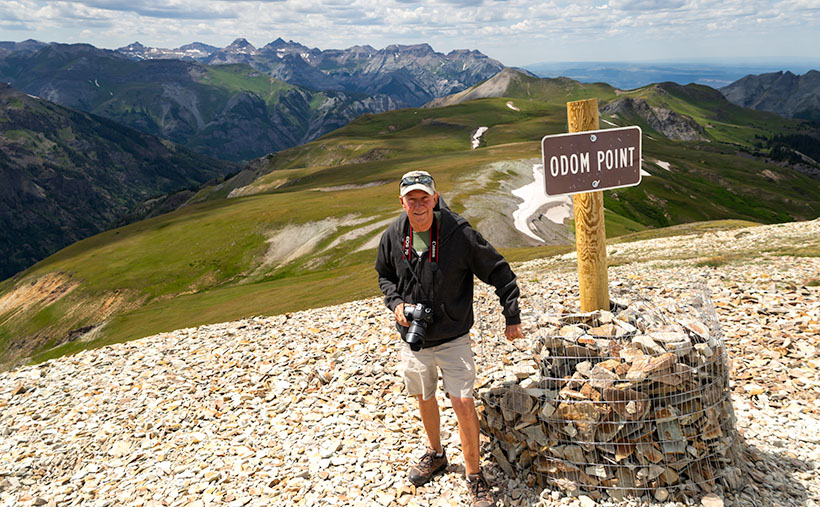
Even though we had to wing it, I think that the day in the mountains Fred and I had was a very successful adventure. We both got a lot out of it. Fred was able to put his—new to him—Toyota FJ through its paces, we saw some beautiful rugged country, we took a lot of pictures, and we came back in one piece. When we got back to base camp, our wives—Deb and Queen Anne—knew we had a good time from the big bug-stained grins on our faces, and the incessant chattering about our day.

We visited four of the two dozen high passes in the San Juan Mountains, and those were the day’s high points (pun intended) of our trip. Coincidentally, that’s enough material for a typical month’s worth of blog posts. But September has five Sundays this year, so I get to show you another picture that I took; of the twenty-two keepers, this one is my favorite.

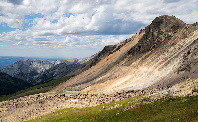
I don’t usually work this way. When I’m out alone with my camera, I try to work a scene. I’ll shoot several angles, zoom in and out, add or remove elements in the composition, or maybe wait for better light. When I’m back at my desk, I’ll review the raw files and pick out the best. I don’t bother processing most of my shots. In Colorado, we covered a lot of area in one afternoon, and I was just along for the ride, so I snapped pictures when I could before moving on. For most of the day, the light wasn’t to my liking, but the mountains were strong enough to stand up in less than ideal conditions. As dinner time approached, the sun’s color began to warm, and the scattered clouds cast shadows on the peaks.

Poughkeepsie Peak - The late afternoon sun shines on the top of Tuttle Mountain, which overlooks Poughkeepsie Gulch.
Poughkeepsie Peak – The late afternoon sun shines on the top of Tuttle Mountain, which overlooks Poughkeepsie Gulch.

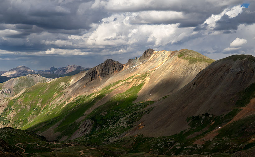
We were almost done for the day, and as we approached Hurricane Pass, I saw this scene on the road overlooking Como Lake. I consider it the best of the day. It’s the fish you pull from the creel after the guys have finished laughing at the other minnows from your basket. It’s called Poughkeepsie Gulch. In this image, the warm afternoon sun is shining through a hole in the clouds on Tuttle Mountain’s top, which is otherwise covered in cloud shadows. The 13,203’ peak overlooks Poughkeepsie Gulch and down there, you can see the road the rangers warned us was too advanced for amateurs like us.

You can see a larger version of Poughkeepsie Gulch on its Web Page by clicking here. I hope you enjoy viewing it. Be sure to come back next week when we feature the scenery from another Arizona back road.

Until next time — jw

Engineer Pass Picture of the Week

When my friend Fred planned our off-road excursions through the San Juan Mountains, his initial itinerary was to complete the Alpine Loop, which includes two passes, circling Red Cloud Peak, Sunshine Peak (which are two of Colorado’s 14,000 foot mountains, but aren’t even in the top 10), and a stop in Lake City. Now that I’ve had time to recover and look at my maps, I think that would be a fabulous trip, especially if we did it later this month when the aspens turn color. But, when we stopped at the Silverton information center, he was told that it’s a seven-hour trip, and it was already afternoon, so we decided to sample some of the passes around Animas Forks instead.

Last week’s image was from Cinnamon Pass, and this week’s picture is from Engineer Pass—our second stop. Both of these places are along the Alpine Loop. If you do Cinnamon first, the route will be counter-clockwise and the opposite direction if you first go over Engineering Pass. The two passes are only miles apart, and most of the Alpine Loop is east of them. Although they’re relatively close, as the crow flies, driving the road requires descending 3,000 feet to the ghost town then 3,000 feet back up the other way. If I thought going up the mountain was exciting, going down was harrowing. I almost got out and walked.

Mountain Man Fred
Mountain Man Fred – It’s not an illusion that Fred’s hanging on to that wire. The sign is well over the slope, and the footing is unsure because of the loose shale.

As we rounded a corner, we saw a knoll where several vehicles were parked, and a crowd snapping selfies and taking in the view. We assumed this was it. It wasn’t. It was Odom Point, and we joined the others for the view and document our visit. As we returned to the road, a sign that said that our pass was further down the road, so we drove another couple hundred yards.

Engineer Pass
Engineer Pass – Looking north from the saddle, you can see two mule trails blazed by prospectors. One leads down into the valley while the other zig-zags up the unnamed peak.

This week’s image that I call Engineer Pass was taken from the 12,800-foot high mountain saddle looking north, and it shows an unnamed peak that’s another hundred feet higher. Also visible are two mule trails, one that descends into the valley and the other that cuts across the talus slope past the red streaks before a switchback as it zig-zags to the summit. I declined to try either of the trails.

While we were taking in the view, I turned around and was stunned to spot over a dozen cyclists peddling up the grade from Palmetto Gulch. No way! We were driving a jeep, and I was out of breath, while these guys were racing mountain bikes on the same road. It’s no wonder that Stephan Pastis ridicules bicyclists in his syndicated cartoon Pearls Before Swine. They’re insane.

You can see a larger version Engineer Pass on its Web Page by clicking here. Be sure to come back next week when we’ll continue exploring Colorado’s San Juan Mountains in Fred’s Toyota.

Until next time — jw

Hualapai Road Picture of the Week

To reiterate what I said in my first post on exploring the Hualapai Mountains, there isn’t much open space there. The little village consists of a cluster of homes, a general store, and the county park for everyone else. There aren’t the amenities that you expect in Flagstaff or the White Mountain communities, but if you like camping and a challenging day hike, the park at the top of Sawmill Canyon Road is a different destination.

Hualapai Road
Hualapai Road-A dirt trail on top of the Hualapai Mountains that reminded me of the Loan Ranger’s opening scenes.

When I first arrived, I explored every road to see what’s there, but the only trail leading out of town soon became to rough and exceeded my road rules, so I turned around and headed back to the park. Before I did, I liked the rustic feeling of the country road, so I composed this week’s featured photo of the scene. I call this image Hualapai Road, although it’s little more than a trail.

The reason that I selected this photo over some others was how the trail curves over a hill between the rocks and trees. It makes me wonder where it leads, and what will I see when I get there. The countryside also reminds me of the opening scene of the old TV show The Lone Ranger that I used to watch as a kid on Saturday mornings. It’s easy for me to imagine the masked hero galloping on his white stallion over the hill—kind of like me and Archie.

You can see a larger version Hualapai Road on its Web Page by clicking here. Be sure to come back next week when we start another series of image from another location.

Until next time — jw

Clay Hills Picture of the Week

July is soon ending, and I’ll be writing about a different mountain range and its backroads next month. In a way, I’m not ready to move on. The Aquarius Range has more that I’d like to explore, and it may be a while before I get a chance to come back. I could use an extra Sunday to squeeze in another story. Oh well—a promise is a promise.

So, this week, we’ll finish up at the beginning or end—depending on your direction of travel—of the Aquarius Range, its south end. Here, there’s no sharp boundary that identifies that we’ve arrived. The mountains just taper into low hills then gently deliver you into the Burro Creek Valley at Six-Mile Crossing.

Depending on the source the Clay Hills or Hell's Half Acre
Depending on your reference these are the Clay Hills or Hell’s Half Acre as viewed from the south end of the Aquarius Range near Burro Creek Crossing.

As you descend from the higher mountains into the valley, you’ll notice a cluster of small hills with buckskin-colored cliffs for which I found two names. On the valley floor, there are Bureau of Land Management (BLM) signs saying these Clay Hills were restoration protection. On my TOPO Maps, however, they’re called Hell’s Half Acre. It amuses me that when pioneers found land that wasn’t flat and plowable, they called it Hell’s This or Devil’s That. I once had a friend who was an Ohio farm boy who told me, “… the Grand Canyon is a wasteland. You can’t grow crops there.”

I took this week’s image after I poked around the Six-Mile crossing for a while. I looked for a pretty shot of the creek running under the Cottonwood trees. The water was slow, stagnant, and choked with algae. It resembled a cesspool, so I gave it a pass, although the shade was pleasant.

As I began driving up into the mountains, I stopped to capture the scene that I call Clay Hills. It was already late morning, and the pretty light was quickly disappearing. The glare of the harsh desert sun would soon replace the warm colors. The camera is pointed west in this perspective and highway US 93 crosses Burro Creek Canyon on the far side of the cliffs. The pointy mountain eight miles in the distance is Burro Peak, so the air was pretty clear considering the recent fires near Prescott. For a cherry topping, I threw in a young saguaro with fresh buds sprouting from its top like the hairdo kids wear these days.

Click here to see a larger version of Clay Hills on its Web Page. Be sure to come back next week when we set off for another adventure exploring more Arizona back roads.

Until next time — jw

Mohan Range Picture of the Week

Have you ever looked at an Arizona road map and noticed the large chunks of unpopulated areas? It seems like the western third of the state is deserted. Most of the time there’s a good reason no one lives there and maps that show the land ownership quickly show why. For example, the military uses much of the land between Interstate 8 and the Mexican Border for bombing practice—what better use of a desert is there? Most of the area north of Interstate 40 and Utah is either the Grand Canyon or tribal land. The western third of Arizona is lower Sonoran or Mohave desert, and it gets a lot less rain than the rest of the state.

Then there’s Arizona’s Bermuda Triangle. Three highways define its legs: U.S. 93 on the west, Interstate 40 on the north and its eastern boundary is Arizona 89. The land included here isn’t desert wasteland; it ranges in elevation from 3-6 thousand feet. It’s transitional grassland, about the same as Prescott Valley. As I look out my window, I see thunderheads developing in that direction—as they do on most monsoon afternoons, so it gets seasonal rain. Why are there no settlements up there?

As I wrote in last week’s post, this month’s area of exploration is the Aquarius Mountains, and my first journey into them was via Upper Trout Creek Road. It’s a short loop road that intersects with Bogles Ranch Road which my map incorrectly identifies. It climbs to a pass and down the far side. At the top, there’s a religious retreat with a parking area wide enough to stop, take in the view, and then turn around, just like I did when I took this week’s featured image called Mohan Range.

Mohan Range-Very few know or have visited the Mohan Mountains in Arizona.
Named for one of General Cook’s Indian scouts, the Mohan Range is seldom visited.

I had never seen or heard about the Mohan Mountains before because as you travel US 93, the Aquarius Range hides them. At one foot shy of 7500’, Mohan Peak is substantial—one of the top 100. I’ve learned since that you can see it in the distance on Interstate 40 and from higher Prescott elevations. As is my way of doing things, I wanted to learn more about these mountains, so when I got back to my office, I hit Google pretty hard. This time I found a goldmine.

The first referral that came back was on a Peakbaggers page. These are people who—for no good reason—like to climb the top 100 mountains in each state (I have no idea what the do in Florida). It’s very informative, well written, and has photos of their expedition. It had a link to a second Webpage written by Kathy McCraine, which has even better photography along with her story of the O-RO ranch.

So why aren’t there any settlements here? Because this land—all quarter million acres of it—is the O-RO ranch (no Dr. Carson, it’s not a cookie). The ranch’s east half started with the Baca Land Float #5. That’s right, one of the authentic Spanish land grants honored by the US Government. According to her story, the original owners merged with a second parcel on its west side­—The Mohan Ranch—to create the most significant and oldest cattle ranch in Arizona. It’s run the same as it always was, cowboys on horses rounding up cattle and sleeping in tee-pees. With no town’s or roads, it a hard life and as Kathy tells it (I love this line), “Cowboy wannabe’s need not apply.” The ranch does not welcome visitors and if you’re the area, you best heed of the warning signs.   

You can see a larger version of Mohan Range on its Web Page by clicking here. Be sure to come back next week when we set off for another adventure exploring Arizona’s back roads.

Until next time — jw

Mine Tailings Picture of the Week

With this posting, we’ve completed this month’s photo excursion of Castle Hot Springs Road. The detour north of State Route 74 started with almost prairie-like flat desert adjacent to the Wickenburg range. Then the road ascended into the Buckhorn Range with a magnificent view of the Bradshaw’s. Next, our back road dropped down to Castle Creek through the Hieroglyphic Mountains past the hot springs resort. Finally, we returned to asphalt at Lake Pleasant where we saw vast groves of saguaros growing on the mountain slopes (I put that in my mental filing cabinet for a future outing).

There was one scene along the way that wasn’t quite ripe enough to shoot when I first drove by it, so I wanted to backtrack and see if it improved with the warm afternoon sun. It did, and it is this week’s featured image which I call Mine Tailings.

Mine Tailings - Tailings comprised of red soil caught my eye because of the color and erosion pattern.
Mine Tailings – Tailings comprised of red soil caught my eye because of the color and erosion pattern.

I don’t know if there are an inordinate number of mines in Yavapai County, but it seems like they’re everywhere. A few hearty souls—that either suffer from unrelenting gold fever or have nothing better to do—still work the claims, but most of the mines are abandoned. When the ore runs dry, the prospectors move on in search of the next elusive bonanza. Because there’s no economic incentive to restore the claim, abandoned mines are left unposted and are often dangerous. Just this year, rescuers have pulled a couple of people trapped in mine shafts. It’s a growing Arizona problem.

One of the tells of an old mine is the tailings. As prospectors tunnel into a mountainside, they have to remove the diggings and pile them somewhere. In massive operations, fleets of trucks build hundred-foot-tall dikes, like the one that used to line Highway 60 in Miami, Arizona. But with smaller claims of one or two men, they will fill a wheelbarrow and walk it outside and dump it over the edge, building a tailings dump; the deeper the mine, the bigger the tailings.

The thing that makes the tailings in this week’s photo interesting to me is that they’re red, and the late afternoon sun exaggerates that color. The red against the blue sky vibrates my eyeballs. There’s more that we can learn from the image, like how old it is. The erosion patterns are deep from many seasons of heavy rain, and its fan pattern is reminiscent of what you see in the Painted Desert. In both cases, water easily cut through soft soil. Finally, dirt and rock that comes out of a shaft is well below the topsoil level, so it’s not rich in nutrients. Here, the desert Mesquite has begun to colonize the hillside, so the soil contains some organic material already.

You can see a larger version of Mine Tailings on its Web Page by clicking here. Be sure to come back next week when we set off for another adventure exploring Arizona’s back roads.

Until next time — jw

Salvation Peak Flag Picture of the Week

Castel Hot Springs Resort
Castle Hot Springs Resort – Originally built in 1896 by the owner of the Congress Mine -Frank Murphy – will reopen in October, so cash in your IRA and visit. I believe the tarp is covering the garden where the chief grows fresh vegetables for the restaurant.

It doesn’t much matter which way you travel on Castle Hot Springs Road, either clockwise or the other way, will get you to the historic retreat—the luxury resort for the rich and famous built in 1896. Your choice of travel depends on whether you want to drive through the mountains via Morristown or north from Lake Pleasant via Castle Creek. As a history buff, I prefer the original route, but I also live closer to the old railroad depot, and I’m too lazy to drive that distance to Lake Pleasant.

After I moved to Arizona, I heard stories of the ghost resort from friends, but I didn’t lay eyes on it for thirty years. After the last of my infamous station wagons was totaled while it was parked in the Sun City Boswell Hospital parking lot, we replaced it with my first SUV—Shadowfax. It was an Olds Bravada with ground clearance and four-wheel drive good enough to begin exploring back roads. One of my first outings was to Castle Hot Springs. As a film shooter back then, I didn’t have a perfect shot of the main house, so I didn’t bother taking any pictures.

There’s quite a bit of history that would make good stand-alone stories. Trivia like:

  • The hot spring found by Ft. Whipple Calvary soldiers tracking bandits.
  • Frank Murphy—the Congress Mine owner—bought the land, built the buildings, and then paid for the road.
  • The resort thrived during the first half of the 20th Century catering to the likes of the Roosevelts, Rockefellers, Vanderbilts, Wrigleys, Zane Gray, and Clark Gable (there had to be famous actresses that visited too, but I didn’t discover any of their names).
  • Murphy’s brother—when he was the territorial governor—turned the resort into Arizona’s Mar-A-Lago because winters were too cold in Prescott. And because Warren Murphy ran the state from here, Arizona’s first telephone was installed in the hall of the main building (I believed it survived the ’76 fire).
  • The temperature of the hot springs water is 12oº, which is the same as every Phoenix household during summer.

There’s another more interesting story, however. During the Second World War, the resort was dark because of rationing and shortages. After the war ended, Walter Rounsevel—then owner and general manager—leased the property to the US Military as a recovery and rehab facility for injured officers. One of those officers was a young lieutenant whose back was injured after a Japanese destroyer rammed his PT boat. The officer’s name was John F. Kennedy, and he spent several months recovering at Castle Hot Springs soaking in the springs, hiking trails, and golfing.

Salvation Peak Flag - For providing a place for injured servicemen to recuperate during World War II, the Castle Hot Springs Resort got special dispensation to fly an American Flag on Salvation Peak 24 hours a day.
Salvation Peak Flag – For providing a place for injured officers to recuperate during World War II, the Castle Hot Springs Resort got special dispensation to fly an American Flag on Salvation Peak 24 hours a day.

For its part in helping with the recovery of these servicemen, a special dispensation was given to Castle Hot Springs to fly an American flag 24 hours a day atop Salvation Peak. The flag is visible along the road before and after passing the resort, and I took several shots of it even though the sun was directly behind. My favorite version is this week’s featured image, and I call it, Salvation Peak Flag. Although it looks formidable, Salvation Peak is a smaller outcrop of Governors Peak which is located within the Hells Gate Wilderness area.

You can see a larger version of Salvation Peak Flag on its Web Page by clicking here. Be sure to come back next week when we’ll present our final photo that I made on my Castle Hot Spring Road outing.

Until next time — jw