Glennallen – Alaska

At the intersection in Glennallen, you have two choices. To the right the road leads south to Valdez. A left turn will take you north back to the Alaska Highway. Other than that, there isn’t a reason to come to Glennallen which is an unincorporated community consisted of an overpriced gas station, an RV park and a Laundromat. So why did we spend five days here?

Mount Sergent Robinson
The Chugach Range is south of the highway and can easily be seen across the river as you drive.

Let’s back up and start with the Glenn Highway, the road we took to get here. Mile for mile, it was the most scenic road we’ve traveled in Alaska. Starting in Palmer it’s an easy three-hour drive, climbing from near sea level to a pass almost four thousand feet before descending into the Copper River Valley.

Gypsum Mountain
The colors in Gypsum Mountain are the result of volcanic cooking. Normally gypsum is white, but iron deposits have rusted the gypsum.

The climb out of Palmer follows the Matanuska River as it cuts a path between the Talkeena Range to the north and the Chugach Range on the south side. It’s hard to see much of the Talkeenas, but the wide river basin really makes it perfect to see the mountains and glaciers lining the south side of the road; each more photogenic than the last.

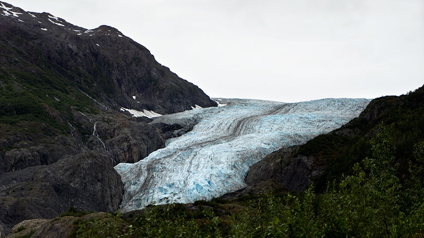
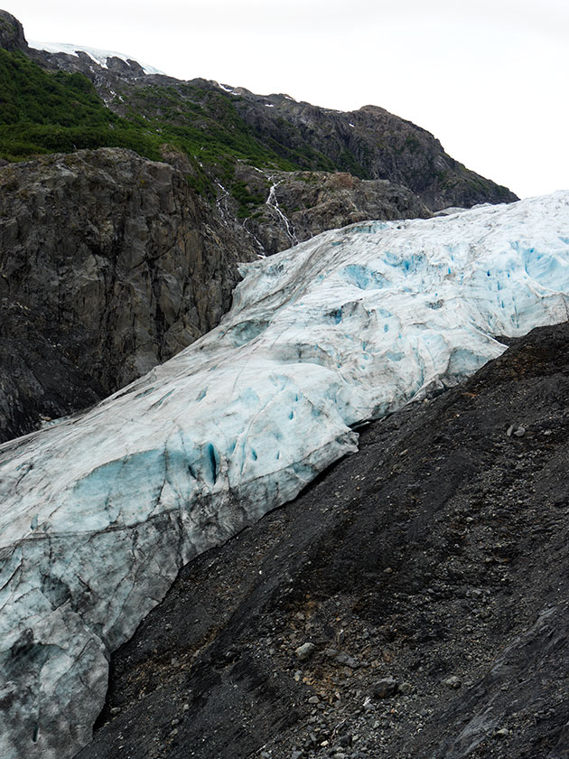
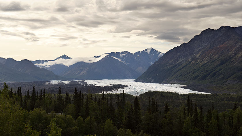
Then at the head of the climb is the Matanuska Glacier, the river’s source. It’s bright white ice flows north from the mountain for miles before curving west at its moraine. The massive ice structure is easily visible from the highway and if you take the time, you can get access to the glacier from the side roads.

Matanuska Glacier
The Matanuska Glacier flows north for miles before turning west at its moraine.

Anne and I got an early start, thinking we’d stop for breakfast at the first café we found. There wasn’t one open until we reached the Eureka Lodge on the high pass. When we stopped we had to put jackets on to ward off the chilly wind. After enjoying ham and eggs the way God intended, It shocked me to find that the price of my coffee was only a quarter, and  our meals were equally reasonable.

Sheep Mountain
When you stop at a place called sheep mountain, make sure to keep your eyes peeled, you may spot Dall Sheep. In this case, my long lens was able to turn the white dots into white dots with legs.

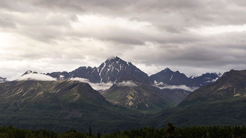
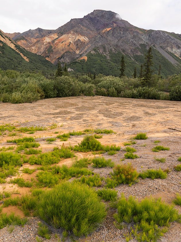
That brings us back to the choices at the Glennallen intersection. While you make a decision, you may want to look straight ahead.  In front of you are three snow-capped mountains. The apparent tallest is Mt. Drum, but it’s only 12,011 feet tall. To it’s left is Mt. Sanford (16,237), and a bit south is the much broader active volcano, Mt. Wrangell (14,163). It’s then you’ll know that you’re at the western border of the Wrangell – Saint Elias National Park. It starts on the other side of the Copper River below you. It is the largest National Park in the US. At over thirteen million acres, it’s the same size as Yellowstone National Park . . . and Switzerland combined. It’s elevation ranges from the sea-shore on its south side to Mount Saint Elias which is over eighteen thousand feet. It is the largest concentration of plus fourteen thousand foot mountains in North America.

Enough statistics for now. Let me sit here for five days and see how much of it I can shoot. There are only two roads that cross the park’s boundary. Both of them are bad, but one I plan to take this week.

jw

Freddy’s Place – Alaska

Many camping neophytes don’t know of the alternative RV campsites. By that I mean the places you can stop and sleep for the night without paying.  The most well known is Wall-Mart. As long as you don’t block the front doors and don’t set the parking lot afire, you’re welcome to spend the night in their parking lot. When you’re on the road, it’s comforting to know that you can rely on those places in a pinch.

Last night we accepted such hospitality at Fred Meyers. That’s a northwest supermarket chain you may know as Kroger. We call them Fry’s at home. We were in transit from Seward to Glenallen and needed to find place to sleep. The Fred Meyer’s places (at least in Alaska) allow you to stay overnight in their parking lot. Since we were in transit for a day, we accepted their hospitality.

At first, we felt like we were imposing, but from our perspective, it was wonderful. We went to the service desk to make sure that it was ok to camp in their lot. The manager assured us that it was ok as long as we didn’t block the front entry. They then added, “You will be moving first thing in the morning, won’t you?”

In all, it was a wise decision to stay. We learned a lot about Palmer by walking its streets that evening, and we found out that they have a steam whistle that blows at five o’clock. It happens the whistle was at the fire station across the street from our parking spot . . . Thank God I was already on the pot; I’m forbidden from telling you what happened to Queen Anne’s pants.

Except for the paperboy who owned the loud rice-rocket delivering papers at 3am, the night was actually quiet and we slept in until eight. That’s when the morning whistle went off. Then I got up with my dopp kit and towel draped over my shoulder and started to march into the store to shave and brush my teeth.

“Sir; you can’t come in here dressed like that!”

“These are my best cowboy pj’s! What’s wrong with them?”‘. . . Don’t ever argue with a box boy.

Anyway, our thanks to Freddy’s, especially for keeping the store open til 10pm so that we could make a Cherry Garcia ice cream run. That got us through the night . . . Not to mention the morning coffee and doughnut fix.

jw

Exit Glacier – Alaska

Alaska must have a state law that prohibits clean cars. This is the last evening of our Seward stay, and it has rained all three days. I know, rain is a minor nuisance. After all, we live in Arizona where the summer rains are only enough to glue the monsoon dust to the paint. I love Seward. There’s enough to see and do here to keep one busy for a month. It’s this campsite that has me down, or more precisely, the two miles of unpaved and pot holed road that leads here.

Like the town of Chicken, when the roads get wet, the mud coats everything. Unlike Chicken, this road’s base is dark gray slate, so its mud/paste is like thin concrete. It gets everywhere. It will cost me ten bucks at the car-wash to get Fritz back to paint . . . and that’s ten bucks one-quarter-at-a-time, because they only have the pressure washers here.

The Exit Glacier could be renamed the Gene Simmons Glacier for obvious reasons.

Today we drove Fritz back into town for a hike up to the Exit Glacier. A large chunk of the Kenai Peninsula is part of a little known National Park called the Kenai Fjords National Park. It includes several of the fjords west of Seward and the Harding Ice Field. The ice field drives several glaciers down the mountains and into the fjords.

The Exit Glacier is one of the few places you can drive up to a glacier. Well . . . you can drive to the parking lot, but it’s a mile hike up to the glacier, and believe it or not, Queen Anne made the hike. There are markers along the trail indicating the receding glacier’s terminus through the years. One couple along our hike had been here a decade ago and they were shocked at how much the glacier had receded since their last visit.

Exit Glacier Up Close
The Harding Ice Field (partly seen here in the upper left) drives all the glaciers in Kenai Fjords National Park.

We didn’t get close enough to stick our tongues on the ice (there are ropes preventing you from doing that), but we did get to see the blue icy interior and moraine. On a quiet moment, we could hear the moaning of the moving glacier . . . or was that me climbing the trail . . . I can’t remember.

Tomorrow morning we head back to Palmer. We have to make a final Costco stop for BBQ sauce ingredients for The Great Rib challenge in Tok (more on that later). After that, we set off to see the largest US National Park . . . Wrangle St. Elias National Park in southeast Alaska. Hopefully, the roads won’t be muddy. Before I retire for the evening, I’ve been commanded to rub the Queen’s feet because they’re sore; poor baby.

jw

Seward – Alaska

Even though the ports of Homer and Seward are both on the Kenai Peninsula, they feel like opposite ends of the earth. Homer is on a headlands overlooking the Kachemak Bay. The thread of sand extending four and a half miles into the bay, called the Homer Spit, is its port. As I said, the geography is similar to the northern Pacific coast.

Old Town Seward
Old town Seward has the usual mix of souvenir shops, bars, hotels and restaurants.

Seward comes from Norway or the fjords of New Zealand. That’s because an ancient glacier carved Resurrection Bay and it’s nearby sisters. The mountains lining the bay rise from the sea like giants cooling their toes in the deep waters. During our visit to the Alaska Sea Life Center (aquarium), we learned that the bay is over nine hundred feet deep. That’s more than enough to support a healthy range of sea life, including whales, sea otters, seals and sea lions.

Red Church in Seward
The St. Peter’s Episcopal Church backs up to the spruce covered mountain.

Seward (named after the Secretary of State that bought Alaska from Russia) has what I like to call charm. There’s the usual tourist things to do like fishing charters, cruises, restaurants and souvenir shops. The mountains and the bay limit the town’s size, so there’s not a lot of new development.

Blue Seward Home
A small residence in Seward with a boardwalk entry.

The park we’re staying at is at the end of a two-mile dirt road along the west side of the bay. Although we gripe about the mud covering the vehicles, this evening, we sat on the office veranda and enjoyed our evening wine while watching the clouds weave among the mountains on the far shore.

Fishing Boat In Reserection Sound
Sitting on the porch at the camp office enjoying the interaction between the mountains and the clouds.

From the porch, we watched the fishing charters come in and hang their catch. It’s a tradition where the crew photographs clients displaying today’s catch. After the pictures, the ship’s crew clean, bag and process the fish for shipping. The gulls love it because they get most of the scraps. This evening a disrupting interloper showed up. It was a bald eagle swooping in to try to snatch the gull’s dinner. The porch lit up with whoops and screams when Deb and Sally realized what the big brown bird was. It was their first eagle sighting of the trip. Who can blame them?

jw

Homer – Alaska

Because Anne and I are a couple of days behind the group, we drove down to Homer for lunch. The rest of the gang was there on Thursday and recommended Captain Patties for seafood on the Homer Spit. The hour drive was along the Cook Inlet coast and we had great views of the volcanoes towering above the inlet’s far shore.

Fishing the Homer Spit
Out on the Homer Spit, you can try to catch salmon using long rods and casting into the bay.

Homer calls itself “The Halibut Fishing Capital of the World.” You can also fish for salmon and dig razor clams out of the estuary pool. Another big attraction is bear tours. You can hire a guide to do the local bears or take a boat to Kodiak Island and watch those monsters gorge on salmon all summer.

Cleaning the Catch
The crew from a fishing charter cleans the daily catch of King Salmon for the clients. They will also freeze, box and ship it home for you.

Most of the town is what you’d expect from a village of five thousand, but all the action takes place on the Homer Spit, a thread of land that extends out into the Kachemak Bay. The paved road is lined with restaurants, tour guides, gift shops, campsites, a resort and finally the ferry at the end. It’s an amusement park, of sorts, lining the narrow road. What little free parking there is has signs that say the greatest parking time is seven days, “No long-term parking.” If seven days isn’t long-term, I don’t know what is.

Ninilchik Eagle
A bald eagle hunts along the Ninilchik River late into the evening.

We walked the spit and then toured the town before making our way back to camp. We sat around camp reliving the days and going over the itinerary for the next few weeks. I wasn’t sleepy after we’d finished, so I grabbed the camera and wandered down to the beach. There I found a bald eagle fishing the Ninilchik River. What a great way to end the day.

jw

Ninilchik – Alaska

We’ve finally moved on from Anchorage on to the Kenai Peninsula. Our first stop is the little village of Ninilchik, a former Russian colony of about two hundred families. It’s on the west coast of the Kenai about halfway to Homer.

Bird Point
Low hanging rain clouds decorate the mountains along the Cook Inlet.

Our drive down yesterday was enjoyable even though it rained most of the way. South of Anchorage, there is a wild-fire along the way, and firefighters hoped that the rain would help them get it under control. As we drove by, the smoke was heavy but there weren’t any visible flames.

Turnagain Pass
At the top of the Turnagain Pass the low white clouds almost came down to the road.

Driving along the Cook Inlet on the coast road was eye candy for me. The low white clouds covered the mountains about waist-high, just like they do in New Zealand. The road crosses a low pass into the Kenai interior before it reaches the coast at Soldotna. Then it turns south and follows the coast. The drive reminds me of Oregon and Northern California.

Orthadox Church
A Russian Orthodox Church overlooks the small town of Ninilchik.

There is difference however. On the other side of the Cook Inlet are a range of mountains including three dormant volcano’s. In yesterday’s rain, they were hidden. Maybe they’ll come out and play today or tomorrow.

Roof Gulls
Seagulls rest on a roof peak in Ninilchik.

The Kenai is Alaska’s Mecca for salmon and halibut fishing. Fred has already booked a halibut charter for tomorrow and we may go back to the Kenai River tomorrow. It’s still season for Kings down here and they say the rivers are full of Sockeye, called ‘reds’ by the locals.

Ninilchik Village
The small village sits on the bank of the Ninilchik River mouth forming a small harbor.

The rest of the group has been here for two days and we all leave for Seward on Monday. With that tight schedule, any fishing I get in will be brief. After all, there is laundry, sight-seeing, photography, shopping and restaurants competing for time too.

jw

Half Empty Glass – Alaska

We’re still in Palmer even though Deb, Fred and Sally have moved on to the Kenai Peninsula. We will meet up with them on Friday. We got Fritz back from the dealer yesterday, after getting the worlds most expensive ignition switch installed. This morning, I took him to the shop for a lube service. I wanted him ready for the long drive home. He’s logged over 5000 miles on the odometer so far; already more than half the scheduled trip, but he’s been on a lot of side trips.

Boat on the Cook Inlet
A wooden boat sits dry in the salt marsh on the Knik River arm of the Cook Inlet.

This is always the time on vacations where I get melancholy. The vacation is already half over. Although there is a lot of traveling left, we’re still on the downhill run. After planning ‘the trip of a lifetime’, I hate to see it come to an end. As I said, there’s more than a month before we get back to the stress and rigor of retirement. We still have so much to see and do.

There’s a line in the Dan Fogelberg song Nether Lands that best explains this confusing feeling I have: “And where do you go when you get to the end of your dream?” I’ve already learned the answer to that question. It’s another quote from the movie Finding Nemo. The line is Dory’s, when she says “Just keep swimming, swimming, swimming.”

My ‘swimming’ technique is like an astronaut coming home from the moon (This is actually how I got through school well before astronauts). I need to focus on getting the landing right, but I stare blankly out the window and let my mind wander. Eventually, another hair-brain scheme pops into my head and (my last quote of the evening is from Tag Team); “Whoomp! There it is.”

jw