I’m down to the last page on my calendar this morning. It’s already time to get a new one. Einstein may have been right about time being relative, but I think he got it backward. Instead of the clock slowing down as you travel faster, time speeds up as you age. Don’t you remember how a week dragged when you had a date on Saturday night? Now it seems like Queen Anne, and I make our weekly run to the garbage dump every other day. What upsets me is that there’s little time for my daily naps anymore.
With a new month comes a new road to explore. We’ve had an extended summer, and it has been a very dry fall, so I initially thought that her majesty and I could go into the mountains. But that all changed recently and we’ve had wave after wave of Pacific storms roll through. Being less daring than I was, I changed my mind and looked for a closer route. One that wouldn’t have snow or mud, or maybe wasn’t even dirt. I mean, we’ve all watched the local heroes on the evening news as rescuers drag them from flooded washes. I’ll only go so far for free-press.
So, I packed the camera, some snacks, and my wife for a lap around Harquahala Mountain using three roads, a triangle of sorts. I’ve driven these roads several times, but not for a photography outing. We started in our neighboring town of Aguila, an agricultural community at the east end of the McMullen Valley. From downtown—the Family Dollar store—we headed south on Eagle Eye Road to the Salome Highway and back to Aguila on U.S. 60. If we weren’t stopping for pictures, we could cover the entire loop in three hours, and the Harquahala Range was out the passenger window the whole time (In the Mohave language, Harquahala translates into: “running water high up“).
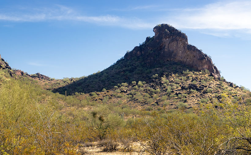
Apostrophe Butte – South of Aguila, I thought Eagle Eye Mountain is a presumptuous name for this little hill, so I renamed it.
We didn’t even get out of town before our first photo stop. Just past the gated airpark—where wealthy Anguillans live—is the town cemetery at the foot of Eagle Eye Mountain. There are two piles of volcanic rock sitting side by side along the highway. The east one is called Eagle Eye Peak, and it has a big hole in it. I’ve written about it before. The shorter western one is called a mountain, which is a generous description at best. It’s hardly a couple of hundred feet high. Compared to the massive Harquahala Range west of the highway, they’re hills. They rise from the surrounding plains, and I’m unclear if they’re part of the Vulture Mountains—15 miles due east, or they are foothills of the western more significant mountain range. Still, they were cute enough to stop and compose a picture.
From the spot where I shot this week’s featured image, I thought that it looked like a punctuation mark, because of the overhang at the top. After further thought, I came up with Apostrophe Butte, which I think is more fitting. All I have to do now is to petition the Department of Names—or whatever you call it—to correct Arizona maps.
You can see a larger version of Apostrophe Butte on its Web Page by clicking here. I hope you enjoy viewing it. Join us next week as we continue our trip around the Harquahala Range.
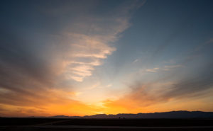
There are good days and there are bad days. I have been out on photo shoots where nothing went right, and then there have been days when everything was perfect. This week’s photo is from one of my better days. Last week, I went on an expedition to Alamo Lake—a place I hadn’t visited before—because I saw a place in a student’s assignment that I wanted to photograph. I spent several hours driving to La Paz County and an hour searching for the right place. I spent another hour or two walking and shooting before I felt like I had what I wanted and packed up for the long drive home. As I got closer to home, the sun was setting and when I turned onto State Route 71, this was the view out of my door window so I pulled over to capture it.
Harcuvar Sunset – After a day of shooting in the desert, I stopped on the drive home to take one last photograph.
I’m pretty ambivalent about sunset photos. They’re beautiful and all, but they’re everywhere. When I was younger I shot a lot of them, then I went through a period where I ignored them. Maybe I’ve mellowed in my old age because I feel like I’ve passed up some spectacular shots because I was too lazy to drive to an open field and I promised myself to rectify that.
This shot—called Harcuvar Sunset—is interesting to me because of the cloud layers. The sun’s last rays color the low clouds while the higher upper streaks are still white. The contrail—usually something that meddles in a photo—seems to be caught in the space between them. I captured this scene at the edge of an alfalfa field in Aguila and the mountains are the Harcuvar Range—I was shooting on the north side of them for most of the day.
You can see a larger version of Harcuvar Sunset on its Web page here. I hope you enjoy my new work and that you’ll tell me what you think. Do you think sunsets are beautiful or are they trite and overdone?
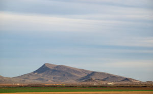
The Vulture Mountains are a twenty-nine-mile long collection of volcanic hills south of Wickenburg. The Hassayampa River runs along the range’s eastern boundary and the mountains taper off to the west. From our Congress home, two peaks rise out of the low mounds on our southern horizon: Vulture Peak’s rounded knob is to the left and the sloping top of Black Butte is on the right. Reminding me of a doorstop or a fallen cake, Black Butte is the subject of this week’s photo.
Black Butte – With its distinctive sloping top, Black Butte marks the western boundary of the Vulture Mountain Range.
The slanting top of Black Butte first caught my attention while I was still working. I drove the forty mile trip from Wintersburg to Congress on the Vulture Mine Road and the butte marked the place where the road turns north. I thought that its shape was the kind of thing you’d see in old western movie backgrounds. I knew that I would use it as a subject some time. A couple of weeks ago while I was shooting in Aguila, there it was waiting for me bathed in late afternoon light.
You can see the larger version on my Website by clicking Here. I hope you enjoy viewing it and I’d love to hear your comments below.
We’re still hanging in Aguila for the new Photo of the Week. Although I drove twenty-five miles to the little town because I had wanted to shoot a specific sign, I then poked around town to see what else I could photograph, and I found the number one reason—if there is such a thing—to visit Aguila. Here’s my shot of the natural window in the hills south of town formed by eagle-head-shaped rocks. Aguila is the Spanish word for eagle; hence, you have the town’s name source.
Eagle Eye Window – Rocks form this window in the shape of an eagle’s head and is in the hills south of Aguila, Arizona.
I’m sure there’s a way to climb up to the window because I’ve seen people there. I didn’t take the time to find a way on this trip, but I saw on Google Maps that there was a trail from the cemetery south of town. As I said last week, there is a good view from the window along US Highway 60 by the working fields of Centennial Ranches. Even a moderate telephoto lens will bring the Eagle Eye closer.
I followed dirt roads between the fields to get closer for this shot. They had street signs, so I assumed the roads were public. It was late in the afternoon when I snapped this, and the beautiful streaky clouds were beginning to get color. I should have waited for sunset, but I wanted to get to another scene that I saw along the trip (which was a bust). You can see the larger version on my Website – Here. I hope you enjoy viewing it. Please let me know what you think by leaving a comment below.
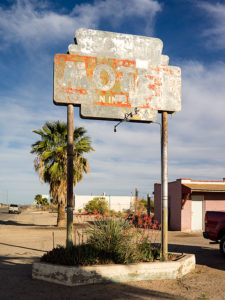
Motel Aguila – A faded sign marks the location of a motel on US 60 in Aguila Arizona.
This week’s new picture I call Motel Aguila, and it’s another faded motel sign for my collection. Located as you would expect, in Aguila—a farming town some twenty miles west of Wickenburg. It’s also across the street from last week’s shot, which is how I spotted it. The paint on this sign is so faded that I don’t see a business name, and there’s only a whisper of letters left to show it as a motel.
As the sign suggests, there is no longer a functioning motel here. The buildings seem to be converted to apartments sheltering migrant farm workers. With less than a thousand permanent residents, there aren’t enough people to work the melon and lettuce fields surrounding the hamlet. The workers have to sleep somewhere and I suppose an old motel is better than the improvised lean-to sheds I’ve seen elsewhere.
Aguila isn’t a destination. There’s a café, gas station, a Dollar General store, and that’s about all. In 1973, Interstate 10 diverted traffic twenty-five miles south, so there isn’t a motel to stay at even if you wanted to. Besides, the only thing to see here is the eagle-eye window in the hills south of town and that’s a fifteen-minute investment along the side of the road (I’ll talk more about the eagle-eye next week).
You can see the larger version on here on my website. I hope you enjoy viewing it and tell me what you think.
“Now for something completely different,” if you didn’t already know, that’s a quote from Monty Python and it’s relevant to today’s post. I’m adding a feature to my blog that I think you’ll like. Since I switched from a monthly newsletter to this blog, I don’t have to post my new images on a monthly schedule. Consequently, I’ve been adding new ones each week and that’s the pace that I like, so I’m going to also write a companion blog post to announce those pictures. When I was doing that in the newsletter it was successful and I hope it works well here on the blog.
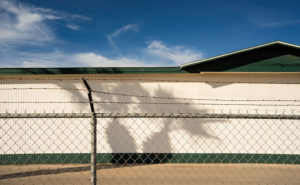
Palm Shadow-The the clapboard side of the Robson Honey Warehouse frames a palm tree’s shadow in Aguila Arizona.
With that in mind, let me tell you about this week’s photo. Over the weekend, I got up enough ambition to load my camera and go out shooting. I wanted to get a shot of the Saguaro Motel sign in Aguila—the little farming community west of Wickenburg on US Highway 60. The sign fits into my collection of old motel signs but after researching the story of Robson’s Mining World I wrote last month, I found out that the Robson family owned the motel and acquired their wealth by selling bee pollen as a miracle cure-all. That fact fits right in with the January photo series of the ghost town. The sign’s not all that spectacular but a shot of it and the accompanying cactus is. Unfortunately, they’re behind a locked chain link fence that ruins the shot, so I’ll have to go back and get permission to get inside the fence.
While I was there, I spotted this image next door. I named the shot Palm Shadow, and it is the shadow of a palm tree cast on the white clapboard side of the Robson Honey warehouse. The building’s green trim serves as a frame for the found wall-art and I included the afore-mentioned fence to give the image depth. It’s a scene that I probably would have missed had I not stopped for my original idea. You can see the larger version here. I hope you like it.
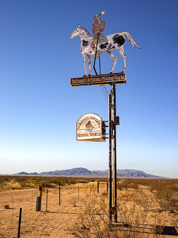
Robson Mining World Sign – The entrance to Robson Mining World is bullet-riddled Yavapai Apache riding a pinto.
I grew up during the era of the TV cowboy. After dinner, my family would gather in the living room and watch shows like Gunsmoke, The Rifleman,Maverick, and Have Gun—Will Travel to name a few. My dad was a tyrant about the shows we watched and we kids were the remote. Maybe that’s the reason I—and perhaps all my generation—have a fascination with ghost towns. We grew up with Tombstone, Dodge, and Virginia City on our TVs, and vowed to visit them one day. Maybe we’re longing for a simpler time—when the good guy wore a white hat.
The ghost towns best known in Arizona are Jerome, Tombstone, and my favorite, Bisbee. All of these places have residents, so they’re not as much a ghost town as they are tourist traps. A mining town’s fortune is dependent on the mineral wealth removed from the ground. The town’s size correlates perfectly with the amount of ore; be it gold, silver or copper. As soon as the ore plays out, people move on to the next bonanza leaving the hovels and shacks they occupied behind. Without maintenance, those relics soon rot or they’re repurposed for sheds, outhouses, or worst of all, firewood. Most often, when you visit a ghost town, the only things you find are a slab or wall. There’s not much interesting left to photograph. Fortunately, there are exceptions where a state or county government acquired and preserved the scene as a park, such as Bodie and Calico in California.
Yavapai County, where Queen Anne and I live, has its share of Ghost Towns—including Jerome—the most famous. Most of the old sites are high in the Bradshaw Mountains, but mining towns are scattered throughout all the Yavapai mountain ranges; including Congress—our hometown. It wasn’t until we moved here a couple of years ago that I learned about the best ghost town ever, and it’s a mere fifteen miles down the road tucked into the south-eastern flank of the Harcuvar Range.
Travel west on Highway US 60 and Aguila is the first small farm community you’ll come to. The name is Spanish for Eagle derived from the eagle-shaped window in the low mountain overlooking the town’s cemetery. The western terminus of Arizona State Route 71 is a mile east of Aguila, and that’s the short-cut you take if you’re heading northeast to Congress or Prescott from California. Just before the road crosses the Maricopa-Yavapai County line is a sign with a bullet-riddled Indian riding a pinto horse. The sign is for Robson’s Mining World—the ghost town you can see at the mountain base. It’s a mining town that no one ever lived in, but has an interesting story nevertheless.
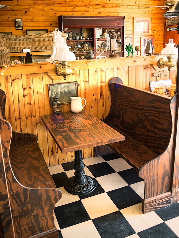
Robson Ranch Booth – When you enter the town’s soda parlor, you’d expect to order a milkshake. You’d be disappointed because it’s all for a show.
The gold mine at the end of the trail was first claimed in 1917 by Westley Rush, an Aguila melon farmer. Rush’s two daughters—Nella and Alameda, for whom the Nella-Meda gold mine was named—managed to hand dig through the first 115 feet of solid rock before Ned Creighton—a Phoenix banker—bought the claim in 1924. Ned hired a crew to work the mine, and over decades he expanded the claim to its present size. His crew worked until World War II when the Feds shut down all private mines. The mining engineer, Harold Mason, stayed on as caretaker and eventually got the property deed after Ned passed.
After the war, Charles Robson was building his fortune by farming, running the Saguaro motel in Aguila, and hustling the health benefits of his local bee pollen. Harold and Charley became acquaintances when Mason let Robson place hives at the mine. There were minerals around the mine that made the bee pollen exceptional and the bees deterred poachers. That informal partnership lasted until 1979 when Charlie bought the mine from the aging Mason. Robson had bigger plans for the place.
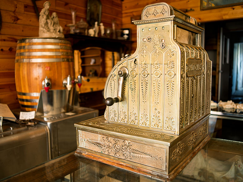
Cash Register – What this old cash register lacks in functionality, it makes up for with class.
Meanwhile, in 1922, Wilber T. Johnson migrated from Missouri to Apache Junction—a community east of Phoenix at the foot of the Superstition Mountains—so he could work in the mines. In 1930, Wilber traded his pick and shovel for an engineering degree from the University of Arizona which made him a highly valued employee. Now we’d call Wilber a hoarder because he collected mine junk—lots of mine junk—for the next fifty years. Johnson got his stash from abandoned mines in the Superstition Mountains, the Mazatzal Mountains, and other mines east of Phoenix and because of its size, his collection wasn’t a big secret. He reputedly turned down a multi-million-dollar offer from Disneyland Tokyo because he knew that they cherry pick the best and discard the rest.
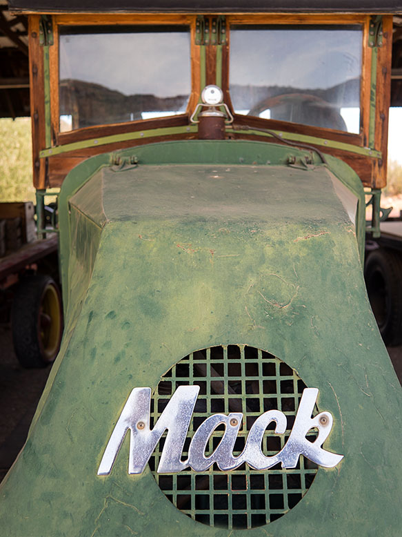
Mack Truck – A classic truck that miners used to haul stuff.
After Charles Robson acquired the mine, he offered to buy Wilber’s collection and the two men finally struck a deal when Charlie promised that the collection would stay intact on Robson’s property. The ink on the signatures hadn’t dried yet before more than 250 truckloads moved decades of mining history to its new home. For ten years Charles, his wife, Jeri, and their sons reassembled the buildings and filled them with the collection’s artifacts. After Charlie died in 2002, Jeri carried on the dream, and toward the end of her life sold the place lock, stock, and barrel to Western Destinations Corporation—the present owners—on the stipulation that nothing ever leaves the property.
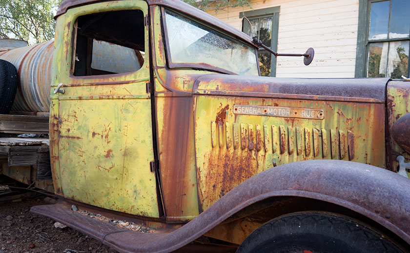
Water Truck – A GMC truck that was used to haul water up from the well to the mine.
There’s a small garden in front of the Opera House where we sat in a mesquite tree’s shade as Brett Bishop told me this story. He’s the current caretaker and he and his family live on site. He’s a young man, and when he’s not greeting visitors he keeps busy unpacking the remaining crates and creatively arranging the contents for display. It’s easy to tell—from the tone of his voice and the sparkle in his eyes—that he loves his job. He calls Robson’s a living museum and he often must unravel the mystery of the items he finds in the boxes.
If you’re a photographer interested in nostalgia, I highly recommend a visit. The cost is $20.00 per person which goes toward upkeep. Don’t count on food or entertainment and even the restrooms are period authentic—that’s right; crescent moons. The mile-long dirt road is navigable by a sedan, except after heavy rains. I know that Robson’s will become one of my resources.