Cochise Ranch Airfield Picture of the Week

Cochise Ranch Airfield - It's common for ranchers in remote Arizona communities to build private airfields.
Cochise Ranch Airfield – It’s common for ranchers in remote Arizona communities to build private airfields.

As a kid, one of the Saturday morning cowboy shows I watched was Sky King. The pitch for the show probably went something like this: An Arizona rancher has a spread so large that he has to use an airplane to manage it. Because our rancher (let’s call him Sky King) has this fantastic resource, the local sheriff calls on him to help find lost hikers, bank robbers, missing children, and commie spies. It’s pretty unbelievable—right? But that’s how it went. Sky King was not my favorite cowboy because he didn’t have a pretty horse. After all, how could you chase bandits and shoot at them if you weren’t riding a horse?

I don’t know about chasing bank robbers, but large ranches with private airfields are common in Arizona. I didn’t realize how pervasive they were until I studied to get a drone license and learned how to read aeronautical charts. There are several private fields near where we live.

I can think of several reasons you could justify a private field if you lived in a remote place like Cochise County. Flying into town for supplies would be helpful, but you’d need a fair-sized plane to bring home packs of Costco paper towels and toilet paper. We have trouble getting those items in our Jeep. Emergency medical visits are second on my list off the top of my head. The rancher files to a hospital, or Air Evac comes out to the spread.

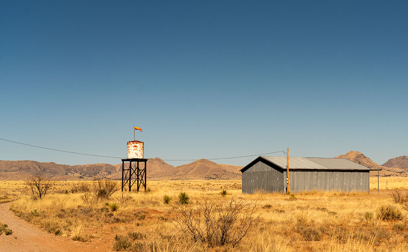
The Sky King Memory block fell into my recollection dispenser when we drove by this windsock and hanger on our commute between Willcox and Chiricahua National Monument. That’s why I stopped and took this shot. I call this week’s picture Cochise Ranch Airfield, and it shows a weathered water tank, orange sock, and corrugated hanger before a clear blue sky. As you look at it, you can hear the announcer’s golden voice saying, “From out of the clear blue of the western sky comes Sky King!” Now that we’re all older and more cynical, don’t you wonder why Penny—a pretty young blond pilot and accomplished air racer—lived alone out in the desert with her flashy old uncle?

You can see a larger version of Cochise Ranch Airfield on its Web Page by clicking here. Next week we’ll stop in a ghost town and look at some of its ruins, so I’m sure that you’ll want to see that.

Till Next Time
jw

Cochise Head Picture of the Week

Cochise Head - The 8087' high peak in the Chiricahua Mountains that resembles the great Apache Chief, Cochise.
Cochise Head – The 8087 high peak in the Chiricahua Mountains resembles the great Apache Chief, Cochise.

Living with my editor-in-chief has been particularly stressful. Her sisters are coming for a visit this week. She waltzed her beloved Dyson through the house while singing to the bluebirds, bunnies, and butterflies. She stressed her red vacuum so much that she broke it and had to order parts from Ireland. I don’t think she’s well—I caught her washing a window. I’ve become the red-headed step-child. I have to eat on the back porch, I can’t use either bathroom, and my office desk is the only place I can sit. When I gave her this post to check, I had to check my hand for missing fingers. Cyndi thinks that if she passes this inspection, her sisters will let her accompany them to the palace ball. She’s forgotten that she already hooked her Prince Charming thirty-four years ago. I blame it on this sudden Bridgerton obsession.

Other than that, welcome to May. This month, we will feature images I took as we drove between Willcox and the Chiricahua National Monument. The satin ribbon that ties the collection together is Cochise County Road 186. Otherwise, it’s a collection of odds and ends that didn’t fit inside the park. Over the next five Sundays, we’ll work our way from the monument and back to town. That way, there’s some logic to my presentation.

Right from the beginning, I’m going to cheat. You can’t see the peak in this week’s picture from the highway, and it’s not inside the park, but you can see it best from there. This image is of the 8087′ high Cochise Head in the Chiricahua Mountains’ northern section. For perspective, the eroded granite head is a mile wide. The name is descriptive because it resembles Cochise, the great Apache chief, with his distinctive Mayan nose and a pine tree eyelash. Like Camelback Mountain, no person is credited for the name; everybody just agreed on the resemblance. Imagine having a mountain named for you while you were alive. Arizona has 15 counties, with 12 of them having tribal names. Cochise County is the only one named after a tribe member. I think that shows how much respect our community had for Cochise (of the other two counties, our legislature named one for a mountain (Graham) and the other for a prominent mine owner (Greenly).

When I shot this week’s picture, I tried different compositions that I call Cochise Head naturally. The one that I chose is centered, which is unusual for me. The others seemed unbalanced somehow. As you move up and down the road, the eye and forehead become more or less prominent. I took this shot from my closest position—standing on a rocky ledge overlooking Bonita Creek Canyon.

Click here to see a larger version of Cochise Head on its website. Next week, we’ll make our way back to town for dinner, but there’s a place we have to stop so I can grab another photo. Come back next week and see what I found.

Till Next Time

jw

Tulip Rock Picture of the Week

Tulip Rock - A formation that I passed on the Grotto Trail that looks like a tulip to me.
Tulip Rock – A formation I passed on the Grotto Trail that looks like a tulip to me.

One of my loyal readers commented that she couldn’t see the rock creatures like me. If you’re like her, that’s ok. Maybe your mind isn’t wound up like mine, or you’re not on the same prescriptions. Whatever the difference is, I’m simply trying to show you the world as I see it.

This week, I have another Rorschach test for you. It’s a picture of a second remarkable formation I found while hiking the Grotto Trail. I call it Tulip Rock because I think it looks like a flower. It could be a rosebud, a daisy, or a dew-covered morning poppy. Don’t see it? As long as you don’t see the Prince of Darkness who’s come to cast humanity into eternal damnation, you’re alright. If that were the case, I’d suggest you consider a change of meds.

When I composed this image, I wanted to show a couple of things. The first is that most of the hoodoos in Chiricahua don’t look like sculptures; they’re ordinary. That uniqueness makes the formations like this and last week even more special. I found two examples (there are more) on my short hike on the Grotto Trail. Imagine the images I’d have if I had visited the Chiricahuas as a younger man.

The other thing that I wanted to show is the background. The higher peaks of this range are along the horizon, including the 9700-foot Chiricahua Peak. As you can see in this image taken in late March, they are still snow-covered. They’re part of the Coronado National Forest—sometimes called the Sky Islands. The forest isn’t contiguous—it includes several southeastern ranges separated by broad basins. I’m not aware of another forest like it in the United States. Feel free to correct me if I’m wrong.

You can see a larger version of Tulip Rock on its Web Page by clicking here. Come back next week when we finally make it to the Grotto—a four-pillar room with a rock roof.

Jeff Goggin

It’s painful to type these words. Jeff Goggin—the other half of the Ballast Brothers Racing Team—died Thursday a week ago (7 April 2022). He was the last surviving family member and lived alone in the family’s Scottsdale home. Jeff’s mother lost a long degenerative battle with Lou Gehrig’s disease. It’s still untreatable. Several years ago, he told me that he was starting to show the same symptoms. Being the insanely practical man we knew, he ended his life to spare himself further suffering while he could still make his own decisions. Jeff is survived by his estranged partner, Paula Hoff.

Jeff was a brilliant, caring, funny man who loved good music, sick jokes, fast cars, fine art, a good scotch, and pretty women. Queen Anne and I miss the jerk.

Till Next Time

jw

Stoned Bunny Picture of the Week

Stoned Bunny - I admit that it's a stretch to see this rock as a rabbit, but Camelback Mountain's Praying Monk is obscure too.
Stoned Bunny – I admit that it’s a stretch to see this rock as a rabbit, but Camelback Mountain’s Praying Monk is obscure.

I love the park service’s pamphlets at the entrance gates. I collect them. In addition to a map, they show all the things to see and do inside the park. When I opened the one for Chiricahua National Monument and looked at all the trails, I thought it looked like a drunken pirate’s treasure map. There are trails on the straight and narrow; trials that go in circles, ones that climb mountains, while others descend into canyons.

Visitors don’t need to hike any of the trails. There are several parking areas where they can take in spectacular vistas. Heck, you don’t even need to get out of the car. However, if you want a genuine Chiricahua experience, you should venture out and walk among the formations. In the World of Rocks, features are hiding from the parking area. Even after all of my recent bellyaching about hiking, I found a short enough trail for me. It’s called the Grotto Trail, and it was pretty level and less than a mile round trip. I completed my tramp in less than 90 minutes, including my photography stops. Over the balance of this month, I will show you the trail’s highlights.

Do you remember several months ago when I wrote how the pixies build trail markers out of stacked rocks—called cairns? Well, there are no cairns in this monument. Using rock stacks to find your way through a park full of stacked rocks is useless. Cairns would be camouflaged. Instead, the WPA installed signposts at junctions and points along the way. How novel.

I found the balanced rock featured in this week’s post not far from the trailhead, so I shot it twice, once on the way out and again on my return. Calling the image Balanced Rock seemed dull because there are so many beside the trails. Then I’d have a series of photos named: balanced rock 1, balanced rock 2, etc. So, as I processed them, I tried to imagine what they resembled. If I close my left eye and stare at this image, it looks like a rabbit with his ears up and the face of Mr. Magoo. If I close my right eye, the image resembles a poorly crafted Easter Island statue.

Trying to decide, I stared at my computer and alternating eyelids when Queen Anne walked into the room, slapped me upside the head, and yelled, “Stop doing that. You’ll put your eye out, kid.” I was on the rabbit at the time, so that’s how it got its name—plus, I ate Stoned Rabbit at a fancy Italian restaurant once; it tasted like chicken.

You can see a larger version of Stoned Bunny on its Web Page by clicking here. Next week I’ll show you another shot that I took on the way to the Grotto. Be sure to come back and take part in the fun.

Till Next Time

jw


Schwertner House Picture of the Week

Schwertner House - Built as an overnight barracks for Army officers during the Apache Wars, the Schwertner family bought and lived in the house until 1980.
Schwertner House – Built as an overnight barracks for Army officers during the Apache Wars, the Schwertner family bought and lived in the house until 1980.

In 1880, when Southern Pacific established a whistle-stop in Willcox, there was peace everywhere in the country except in Cochise County. Here the Army was busy battling Cochise and Geronimo in the Chiricahuas. Stupid decisions made by Army officers prolonged the Apache Wars, but that’s another day’s story.

The U.S. Army operated from several forts in the southeast corner of the Arizona Territory, and the newly built railroad was an efficient way to get officers into Arizona. So, the Army immediately paid to have a boarding house built within walking distance of the Willcox train station. The green officers had a place to stay until troops escorted them to Fort Bowie, Fort Grant, or Fort Thomas.

After hostilities ended, Joseph Schwertner bought the barracks for his family’s home. Joe was a well-off Schley saloon owner, one of several that lined Railroad Avenue at the turn of the century. After Joe died in 1929, his heirs continued to live in the house until 1980, when they gifted it to the local historical society. Today, the pretty little yellow house with green shutters is one of several buildings in Willcox on the National Registry list and is open for tours.

In this week’s picture, I shot the historic home at dawn just after I got my first cup of coffee and my eyes finally opened. I called the shot Schwertner House—its proper name. In addition to the lovely morning light on its yellow front and new metal roof, I like the picket fence (I’m a sucker for picket fences because they’re rare in Arizona). The dark green shutters should be next on the TLC list.

What if you’re not into history and old buildings? What else is in Willcox that makes it worth a visit? A mile or so east of the railroad crossing is the town’s golf course. It’s not fancy, and it will never be on the PGA tour, but that’s not important to most golfers. I’ve never been good at stick-and-ball sports, so I’m not keen on golf. However, on the road and just past the course is something that I do find exciting.

Willcox Playa Sandhills - Sandhill Cranes stop at the Wilcox Playa on their way to Canada.
Willcox Playa Sandhills – Sandhill Cranes, stop at the Wilcox Playa to rest and feed on their way to Canada.

We started our Willcox story a couple of weeks ago by explaining why Southern Pacific picked this spot for a stop. The railroad located the town along the northeast part of the Willcox Playa. Usually a dry lakebed, there is enough seasonal water to fill the low spots. Because these shallow pools are dependable year after year, migrating waterfowl stop for food and rest.

The most notable flock of birds is the Sandhill Cranes. The large stilt-legged gray birds are in the ponds late winter until the weather warms enough to continue to Canada. The playa is the best place to watch the red-faced birds this side of New Mexico’s Bosque del Apache preserve.

Since the access road encircles the ponds, you can watch the cranes from your car. In freezing mornings, the birds cluster in tight groups, communicating with trills, clucking, and squawks. Before they take to the air, their cacophony gets louder and the pace quicker. Then a half dozen take a couple of steps and flap their long broad wings rising gracefully above the pond. In winter, the air in Sulfur Springs Valley has temperature inversions, so the birds fly up to where the air is warmer and soar over town. The locals proudly call the phenomena Wings over Willcox, or WOW.

You can see a larger version of Schwertner House on its Web Page by clicking here. Next week, I have a final shot of historical Willcox, so come back and see what we’ve dug up.

Until next time — jw

Mack’s Bar Picture of the Week

Mack's Bar - Something that its patrons may never see is the early morning sun shining on Mack's Bar in Willcox, Arizona.
Mack’s Bar – Something that its patrons may never see is the early morning sun shining on Mack’s Bar in Willcox, Arizona.

“Gee, had I only known …” I don’t know about you, but I’ve uttered that phrase a lot. I shouldn’t be surprised because my mom always told me that I “was a day late and a dollar short.” And, I always thought she called me sun because I was so bright.

This time I whispered the idiom to myself after getting back from our Cochise County trip. As I always do, I began looking for stories that complement my pictures. I found a great story about another Earp shooting. Not Wyatt. That would have been too good. This incident involved the shooting death of Warren Earp—Wyatt’s youngest brother—at 1:30 am July 6th, 1900, in the Headquarters Saloon.

If you’re not familiar with the controversial Earp brothers (where have you been), they were supposedly the good guys at the OK Corral shootout in 1881—even though they wore the black hats and black dusters. I don’t want to dwell on the Tombstone incident, but the short version is that Wyatt, two of his brothers Virgil and Morgan, and their friend—Doc Holiday went to the corral to disarm four Clanton Gang cowboys. The confrontation erupted in a 30-second gunfight where the Earp’s killed Tom and Frank McLaury and Billy Clanton while Ike Clanton managed to run away. (In this video, Bob Boze Bell—former DJ, artist, and publisher of True West magazine—explains the shootout’s story better. It’s longish but interesting.)

Warren wasn’t in Tombstone at that time because he was too young and lived with his parents in California, but he later got entangled in the subsequent vendetta that lasted another year. By 1900, Warren had settled in Willcox, a mountain range east of Tombstone. He worked as a stage driver for the mail and a Sierra Bonita Ranch hand. It was at the ranch where he and Johnny Boyett became close.

On the fateful night, Warren and Johnny got into a shouting match in the saloon on the northeast corner of Maley Street and Railroad Avenue (diagonally across the street from last week’s train station). As their argument heated, they threatened to kill one another, although neither was armed. Short-tempered Warren and Boyett left the bar separately. Earp wanted to cool off, and Johnny went to get a gun. When Warren returned through the back door, Boyett shot at him four times. He seemingly missed on purpose. Earp taunted the ranch foreman and opened his duster to prove he didn’t have a gun. “Don’t come an inch closer,” Johnny shouted, but Warren continued. Johnny fired another round sending a bullet through Earp’s heart. Warren fell foreword, dead onto the floor. Then things got weird.

Between the 1:00 am shooting, and sunrise, Earp’s body was dragged to the cemetery and buried in an unmarked grave. Meanwhile, the Sheriff arrested Johnny. Then he got the local judge out of bed. They held a trial, where the witnesses testified. Finally, the judge determined the shooting was justified and freed Johnny Boyett. The incident was closed and sealed forever.

There is a tantalizing clue, however. In the 1930s, a reporter interviewed a woman living in Prescott’s Pioneer Home. Her name was Mary Cummings—she was also called Kate Elder, but she was best known as Big Nose Kate. She worked as a prostitute in Tombstone and was Doc Holiday’s common-law wife. During that interview, she recounted her memories of the Earp brothers and said Warren’s death “… was the result of an altercation between two individuals involved in an unnatural male relationship.”

How does this week’s picture fit into this story? It doesn’t. The Headquarter Saloon burned to the ground sometime after the shooting, but the builders used the foundations to rebuild an identical structure. It’s repurposed now—ironically as a wine-tasting room. While I was shooting in Willcox, I didn’t feel it worthy because it has a tacky sign painted on the white stucco. This week’s photo—Mack’s Bar—is also on Maley Street, a block west of where our story took place. So, it’s a bar, it’s on the same street, and that’s as close as I got.

You can see a larger version of Mack’s Bar on its Web Page by clicking here. Next week, I have another picture from Willcox, and maybe I can find a story that goes with it.

Until next time — jw