Everywhere I look, the desert is yellow, and it’s as thick as a jungle out there. When Queen Anne and I run into town, the train tracks—only a block from the road—are hidden behind the dense foliage. I supposed this was predictable with the good rains we had this winter. We had a good crop of poppies this month along with purple lupine and orange mallow lining the highways.
Several plants give to the yellow with the first to bloom is the Brittlebush. Their soft yellow flowers look like small pale yellow daisies on stems rising from sage-green leaves. Unlike the poppies, their color isn’t vibrant, but they’re so pervasive that they’ll turn mountainsides yellow. They thrive in disturbed soil, like the highway shoulders.
Creosote bush adds a second note of yellow. The lowly creosote is like the lawn of the desert, except it grows 4-6 feet high. A couple of weeks ago, the field across from the park was Kelly green. The bush’s flower is small—almost like buds, and now that they’ve popped, the green has a golden tint.
The yellow crescendo comes when the Palo Verde bloom. Last week, Her Majesty and I ran down to our dentist at the border, and along the way, the trees were already blooming in the low-lands. The bloom moves through the desert like an opening curtain into the highlands. Today I see the trees in our park are beginning to show the tiny flowers. At their peak, the Palo Verde dot the mountainsides with yellow splotches. It’s then you realize that they’re growing everywhere. There’s a color symphony, and quail provide the background music with calls as they stake out their territory. It’s the best time to live in the Sonoran Desert.
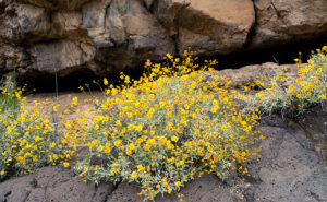
Lava Tube and Brittlebush – Three of the flowering plants grow among the rocks below a lava tube.
When Fred and I were out taking photos in Black Canyon a couple of weeks ago, I saw lots of brittlebush growing in the lava rock cracks. Their soft yellow popped against the dark, almost black canyon walls. Since they screamed, “Spring,” I wanted to capture the contrast. Out of the several shots that I took, I liked this week’s image best.
In the shot that I call Lava Tube and Brittlebush, three plants were growing below a gaping void in the rocks. I believe it’s a tunnel that formed when the molten magma lost pressure then receded. It’s just like when you were little, and your older brother tortured you by pinning you to the floor then drooled over your face but sucked the spit back at the last moment. The threat was always worse than the spit. Oh! By the way, on your first desert visit, inevitably someone will tell you, “Don’t sick your hand into any place you can’t see.” The lava tube is an excellent example of what they mean. I tried to get Fred to see if he could find any rattlers in there, but he refused. He was no fun at all.
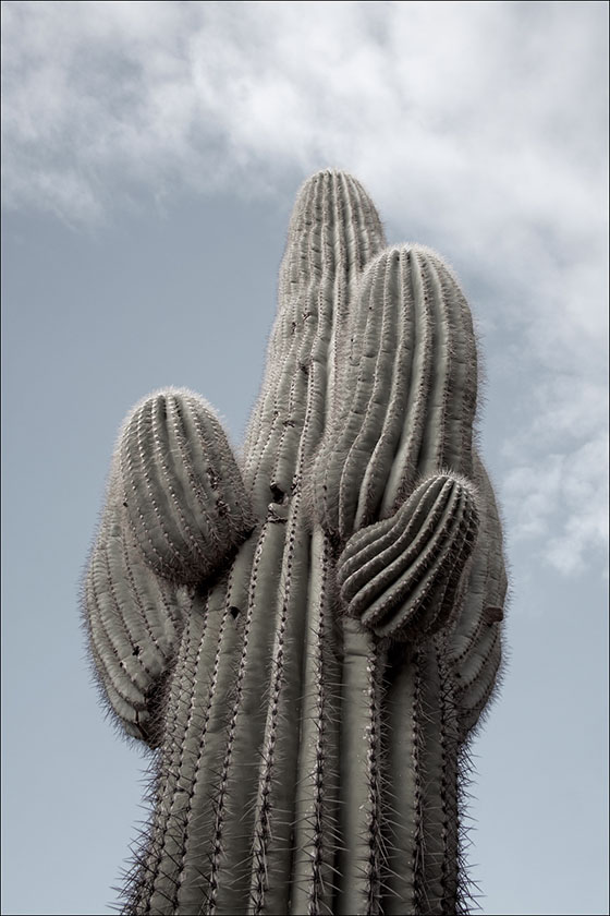
Oh, if you’re wondering how brittlebush got the name, here’s an example of how they look after a couple of weeks without water.
You can see a larger version of Lava Tube and Brittle Bush on its Web Page by clicking here. I hope you enjoy viewing this week’s post and next week; we’ll show another featured image from a different Arizona site.
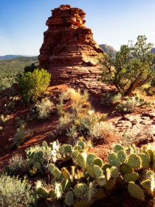
Have you ever been to a place, but you didn’t know you were there until you went away? I know that sounds like a Yogi Berra-ism, but it will make perfect sense once I explain. Most of the time when I’m out shooting, I have to come back to the office and scour maps to name the landmarks that are in my pictures—and you thought I was a human geography book. That’s the story behind this week’s featured image that I call Vortex.
Vortex-I was able to compose two photographs standing on the Boynton Pass Overlook. I found out later that it’s also the location of one of the four Sedona vortexes.
For Sedona month, I wanted to get images of the red rocks that aren’t on every calendar that you’ve owned, so I scouted and explored a couple of trails that were off the beaten path. One of them was the Boynton Pass Overlook Trail, and I took the Climbers photo featured three weeks ago from the same place. Back at the office, I searched Google Maps to see if the pinnacle they were scaling had a name. It didn’t (Wrong. According to the site in the following link, its name is Kachina Woman – jw), but—according to the map—I was standing on (or near) the Boynton Pass Vortex. When it comes to those kinds of metaphysical things, I must admit that I’m a skeptic, so I wasn’t searching for a vortex. I was after the view. It’s interesting that there isn’t a marker to show it’s there and I didn’t come away enlightened. I did, however, get two photos from one spot, so maybe …
This smaller turret and the much taller tower as seen in Climbers flank each end of the overlook saddle. Since they’re on opposite ends, if you look at one, you have to turn around to see the other. I liked the shape of this little guy—it kind of looks like an inverted tornado. I don’t know what a vortex looks like, so maybe this is one.
Another thing that appeals to me is the plants. Within the frame, are all the varietals that make up the Sedona chaparral: juniper, sage, prickly pear, agave, and some others that I can’t identify by name. I’d like to think that this shot is a miniature Sedona model—a stack of red sandstone and the plants thriving there. If I had a stag deer majestically posing in the photo, it would have been perfect—or maybe have it spinning through the air like the cows in the movie Twister.
You can see a larger version of Vortex on its Web Page by clicking here. I hope you enjoy viewing this week’s post and come back next week when we’ll start another month in a new site.
The suffering that I must go through to please you people. As I sit here on the couch and looking at my right leg propped up by a pillow, I see that my ankle is thicker than my calf muscle. I had a friend in high school—a girl—who’s legs looked like this. She always lamented that they installed her legs upside-down. That’s how my right leg looks now.
I managed to injure my ankle by twisting it on the hike back from Coyote Gulch in Utah. My pain worse because I didn’t get the shot I wanted. I was this … close. I allowed four hours to trek out, get a shot, and then hike back before the sun went down. The two-mile trail alternated between fine red-powder sand and slick rock which I preferred because I made better time while I walked it. As I neared the canyon, I was concerned because I couldn’t see it. It’s the same as Horseshoe Bend on the Colorado River, so you have to walk to the edge to look into the chasm. The photo shows just how close I got and when I took it, I was not on the trail. What you can’t see in the picture is that beyond the cairn the trail descends like walking down a ball. To get back up, I would have needed to crawl on my hands and knees. Incidentally, that’s a very narrow ridge to be carrying a camera pack and tripod, so yes, I was a-scared. (BTW—here’s a link to what’s down there. It’s copyrighted so I can’t post it, but I can send you for a look.)
The Top of Hamblin Arch-This is how close I got to my subject. You’re looking at the top of Hamblin Arch, like looking at an elephant’s trunk from its brow. The cairn on the ridge marks the real trail. Behind the cairn, you can make out the arch underside.
I twisted my ankle a third of the way back, and it’s the third time I’ve injured the same ankle. Each time I was carrying a load and my foot rolled-over 90º so that my entire weight was on that pointy ankle bone. Like the other times, I didn’t have a choice but to keep walking and the two-mile trail turned into four miles, then six. I became concerned that I wouldn’t be able to get back to the truck before dark. I began having thoughts about my demise. I wondered if I’d have to eat the dead, except I was alone. I questioned when my camera and tripod would become so much of a burden that I’d discard them along the trail. In case you’re worried, I didn’t die. I got to the truck at sunset and spent the night alone under the stars. I drove back to town the next morning and called my caring wife to tell her I had to come home early—she would need time to get rid of her boyfriends—the Chippendale Dancers.
I think that after the first injury, my ankle is susceptible to re-injury. I wear good hiking boots, and because of their high tops, they have more support. With all the walking, hiking, and biking I’ve done in the past couple of years, I thought my ankle would be stronger. If I want to get back out there and get those out-of-the-way shots, I’m going to have to do strength training exercises and tape my foot up before a hike.
Instead—I’m buying a drone. The one I’ve settled on has a four-kilometer range, and I could fly it out there and get my shots from the parking lot. I’ve pondered how to get more height in my photos anyway, and a drone is a perfect answer. A drone is a medical necessity—no less than an Iron Lung. The challenge I have is that I want a quality camera equal to my current gear. That camera is $21K, and lenses start at $10K. A drone stout enough to fly it is another $7K, and the controller is another couple of grand. Sure, fifty-thousand dollars sounds like a lot of money, but that’s the cost of an emergency room visit and a couple of nights in intensive care. I wonder if my health insurance will cover it if my doctor writes a prescription.
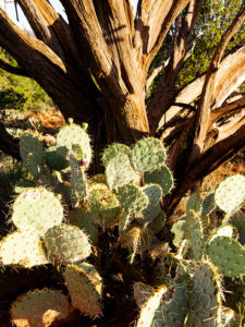
In a place like Sedona, with its canyons and red-rock buttes, it’s easy to get overwhelmed by abundant beauty. I can imagine a project where I simply recorded a catalog of the natural formations along Oak Creek, but that would make for a boring story. A good story changes pace and adds contrast. That’s why, as I scurry about hither and yon at a new site, I keep my eyes open for interesting things below my nose.
Prickly Juniper – A prickly pear cactus grows in the sun beneath a dead juniper tree in Sedona Arizona.
This week’s featured image—called Prickly Juniper—is an example of looking for intimate subjects amidst spectacular scenery. I saw this prickly pear along the trail that I wrote about last week. If it were on its own, I probably would have ignored it, but it nestled under the bare branches of a dead juniper tree and together they caught my attention. I liked the light against the dark, the living against the dead, and the prickly pear’s circular pads against the tree’s linear branches. The late afternoon sun was showing off the tree’s texture and the cactus’ lethal thorns. I took a couple of variations of this image and I felt this version was the best.
You can see a larger version of Prickly Juniper on its Web Page by clicking here. I hope you enjoy viewing this week’s post and come back next week when we’ll present another featured image from Sedona.
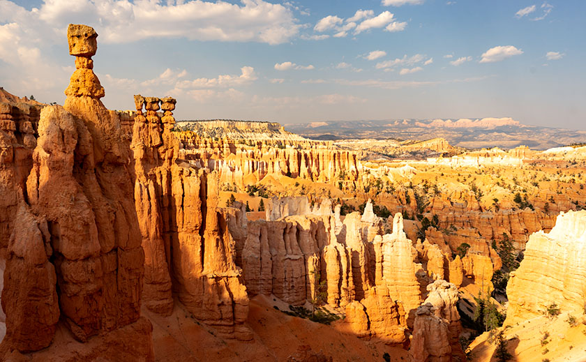
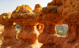
Thor’s Hammer And Sunset Point – As the Navajo Trail descends, it passes by Thor’s Hammer, Bryce Canyon’s most iconic hoodoo.
Of all the sights to see along Utah’s State Route 12, Bryce Canyon is the crown jewel. All of the other stops along the way are sideshows. The park draws people worldwide and they have to use SR 12 to get to it. I, however, am a weirdo that stops at Bryce because it’s part of the highway. Interestingly, Route 12 cuts through Bryce’s north-east corner, so you get a taste of the Bryce Canyon without leaving your car.
We’ve been to Bryce a handful of times and it’s one of our favorite national parks. With elevations exceeding 9,000 ft, it’s always cooler than home. It has alpine meadows and forests of spruce, fir, and aspen, which are a definite change from cacti. There are great views from the overlooks dotting its 38-mile road and you get an understanding of the Escalante Grand Staircase when you look down from the top. Finally, there’s wildlife—if you don’t see at least one deer while in the park, well … you’re just asleep at the wheel.
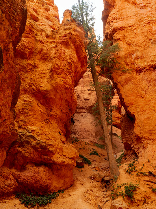
Leaning Tree – At the canyon’s bottom are amazingly tall fir trees growing between formations like they were stretching to reach the light.
Like most visitors, Anne and I stopped at the overlooks on our previous visits, but I wanted to do something different this time. While we were in the visitor’s center, I asked the ranger about the trails and she recommended the Navajo Trail to get the photographs that I was looking for. It’s a loop trail that’s less than a mile and a half long. On their chart, it was a moderate hike because of its 500 ft elevation change. I thought to myself, “Piece of cake, sign me up.”
Before tackling the Navajo, Anne and I drove to the road’s end—Rainbow Point. That’s the park’s highest elevation, and in addition to the great view, there’s a flat trail—for Bryce Canyon—that loops through a grove of bristlecone pines. After completing the loop, we concluded that the bristlecone grove at Cedar Breaks was healthier, larger, and a better experience if you like walking among these ancient trees.
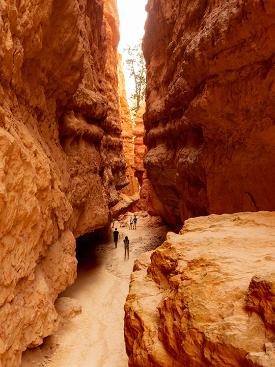
Wall Street – The Navajo Trail passes through a section called Wall Street where you’re dwarfed by the cliffs like a ‘Lord of the Rings’ setting.
As we drove back to Sunset Point where the Navajo Trail is, Anne called our insurance agent and demanded that he increase my life insurance policy—she of so little faith. When we arrived, we couldn’t find a parking space and I questioned if anyone was still at home in Europe. All of the spaces were full and a queue of three cars waited for each potential empty spot. We decided that I should go and Anne would circle the parking lot—like you do at the airport—until she found an open parking spot. With a kiss for good luck, I grabbed my camera and backpack—with water—which burst open and emptied before I made it to the rim—and set off on my great adventure.
Let me describe the Navajo Trail. On the map, it’s a 1.3-mile loop with a 500 ft elevation change. I hiked down 500 ft on switchbacks for three-quarters of a mile. At the bottom was a log-bench that felt good to sit on. Then I walked around a column and began the trek up another set of switchbacks climbing 2,000 ft in under three miles. If I went in the other direction, the numbers would have been the same. It was one of the most exhilarating things I have done in my life. I didn’t understand Bryce Canyon until it swallowed me.
Navajo Emerging – As the trail begins to emerge, it feels like breaking the water surface after a dive.
I made my journey in 1½ hours, but I was taking photos as I plodded along the trail. I resented the kids and a young man who ran up the hill wearing flip-flops. George Bernard Shaw was right when he observed, “Youth is wasted on the young.” I’m glad that I made the effort because I got a different perspective of Bryce Canyon in a mental sense and in my work, which I hope you enjoy viewing.
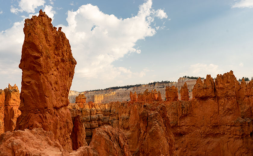
I photographed the second featured image in our Utah series on the west rim of the Paunsaugunt Plateau north of Utah SR 12. This is the plateau where Bryce Canyon is located, but this is on the opposite side. Before entering Red Canyon, there’s a dirt road that heads north to Losee Canyon (not misspelled) and the trailhead located there. In the parking lot, with a little searching, you’ll see a sign for the Arch Trail—it’s a short loop that climbs up and around the plateau’s edge. Like most trails in Utah, the Arch Trail goes up or comes down. It’s anything but level.
The Arch Trail wanders among interesting rock formations including a couple sets of hoodoos—like the ones in this week’s photo. If you’re lucky enough to wander off the trail at the right spot, you’ll find the arch that the trail is named for. At the summit, you’ll enjoy a great view of the Panguitch Valley and the Markagunt Plateau in the west. It’s not a well-maintained trail like you find in national parks, but it’s easy to follow once you’ve found it, and rangers built several flights of stairs in the difficult spots.
There are places outside of the Utah Parks where you can hike among the hoodoos and arches. Arch Trail near Red Canyon is one of the easier ones.
I chose this image because hoodoos always seem distant things. In this case, the trail goes right up to them. You can touch them, pose your kids in them, walk through them, and unfortunately, you can deface them with “Kilroy was here – 2018” as some people have. In this shot named Hoodoo Windows, I tried to show a feeling of intimacy with the structures. I was lucky that the light was good when I arrived at the scene—it was dinner time and the sun was on its way down.
You can see a larger version of Hoodoo Windows on its Web Page by clicking here. I hope you enjoy viewing this week’s post and come back next week when we present another image from a different Utah site.
Hi, I’m Jeff, another one of Jim’s long-time friends. Jim recently invited me, along with his other friends to write a guest post for his blog. I presume he thought his friends would jump at the chance to give to his blog and like Tom Sawyer, his friends would paint his fence. I was onto him though and intended to politely decline, because I find writing too much work and I have done quite enough of that for now, thank you. But as I was drafting my response to his email, my fingers somehow typed the words “Sure … it sounds like fun” and now I’m stuck. I hate when that happens. There is no pain worse than self-inflicted pain!
Because I didn’t have any ideas what I might write about, I subsequently asked Jim if he had any particular topics in mind. Unfortunately, he wasn’t very helpful, suggesting only that I should write about something that’s related to travel or photography, even if only minimally. Oh, and if possible, I should try to make it humorous, too.
Well … okay then.
Unfortunately, my past and present family circumstances have been/are such that I’m not able to travel very often nor very far these days. Instead I wind up photographing my dog, Miss Abby, while we’re out walking. I have a photoblog where I post the resulting photos: https://abby.aminus3.com/. The only photography I do nowadays is typically done late at night while I’m walking around well-to-do Scottsdale neighborhoods with Miss Abby in tow or in the seedy, grimy downtown Phoenix warehouse district.
While I’m not able to travel as often or as far as I would prefer, I do still enjoy getting away from it all when I can, even if only to a small and very temporary degree, and the very best way I’ve found to do that is to take a hike … literally. Fortunately, I live in the geographic center of Scottsdale, which means there are two hiking areas within a 10-minute drive from my house and three more within 20-minutes, all of which are part of the McDowell Sonoran Conservancy project (https://www.mcdowellsonoran.org/).
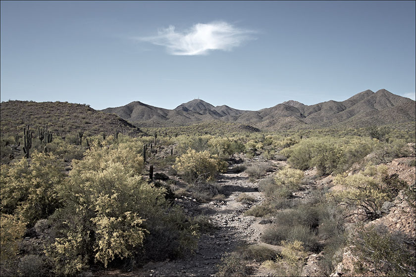
The broadcast towers visible on top of Thompson Peak are the only clue that one isn’t in a pristine wilderness.
At each of these hiking areas, I can hike for several miles without backtracking over the same trail and better still, once I’ve hiked 15 minutes or so away from the trail head, it’s surprisingly difficult to tell that I’m on the outskirts of the fifth largest metropolitan area in the U.S. instead of way out in the remote desert, miles from anywhere (The only thing that occasionally ruins the illusion is the broadcast towers visible on top of some of the nearby mountains). The time commitment is small; two to three hours, max, round-trip from my front door. These trips require minimal planning, so I can usually be out the door and on my way within 10 minutes of when the urge to get away hits me.
Within 10 minutes drive from my home, I can immerse myself into nature.
While I’m not much of a landscape photographer these days, I always bring a camera with me and practice what I have come to call “hikography,” which means taking photos while I’m hiking, sometimes even one-handed and without breaking my stride. It’s roughly similar to “street photography” (walking around with a camera and recording scenes of everyday life), except that in the desert, there are no streets, only trails … and a lot fewer people.
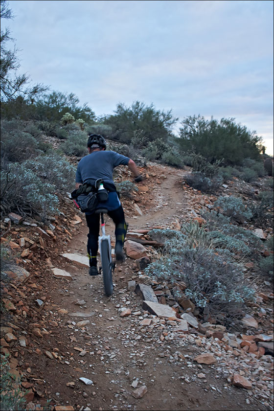
Like Street Photography, you can capture shots of other travelers along the trail.
To my way of thinking, hikography is different from other genres of photography, because hiking is the primary activity and photography is strictly secondary. This means that I leave my tripod home, as well as the extra lenses and filters and other accouterments that are part and parcel of the landscape photography experience, and instead carry a simple, point-and-shoot-type camera in my right hand, secured by a wrist-strap and always powered-on, so it’s immediately ready for use.
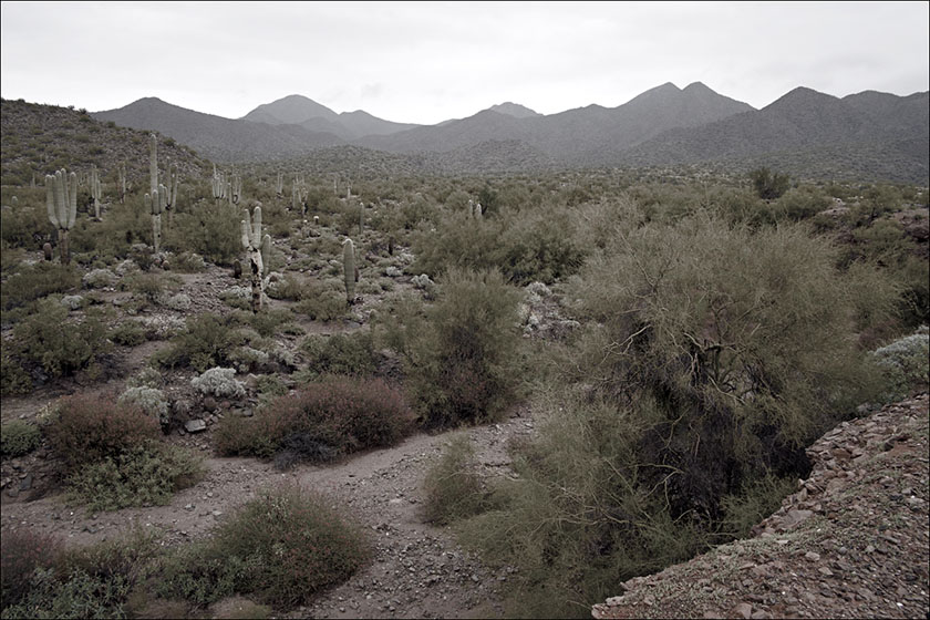
There is always time along the trail to stop and take shots of the giant icons of the Sonoran Desert.
For me, the key to hikography is that it’s not purely photography nor purely hiking, but a complementary combination of the two. Without taking photos along the way, I find hiking pointless and boring; and without hiking, I find landscape photography ho-hum (which is almost, but not quite boring) and largely a waste of time due to the all the standing around and waiting on the ‘magic’ light.
But combine the two and something magical happens, just as when peanut butter and chocolate combine to make Reese’s Peanut Butter Cups. When done together, the two activities, hiking and photography, create a greater, more enjoyable experience than either of them one does when practiced individually. Hiking now has a purpose, a raison d’être, if you will, and photography becomes a tangible experience, not just an intellectual search for pretty scenes to put in front of a camera when there’s good light available. The two activities build upon each other, the way that fine wine complements fine food and a cigarette after sex used to hit the spot. Just ask the Queen … er, never mind.
So now I have a reason to hike regularly, as well as a reason to take photos while I’m doing so. By engaging in both activities simultaneously, I am now actually engaging in both activities, instead of just thinking about doing them … tomorrow … maybe. Did I mention the fitness benefits of hiking? They are real and if it’s done often and energetically enough, hiking can replace a significant amount of time spent in the gym (Unless your gym is amply stocked with attractive, toned women wearing Lycra and Spandex and doing pole aerobics [or, I suppose, depending upon one’s orientation, hunky men pumping iron], this is a good thing. Alas, my gym is not one of those, because it recently closed and I now use the free gym at the nearby Scottsdale Senior Center, which is very aptly named. Needless to say, given my options, I would much rather spend my time hiking in the desert than working out at the gym.)
By now, you’re no doubt thinking, Well, … this is all well and good for him, but I don’t live in the desert with many hiking areas nearby and I’m not very good at using a camera, either, so what good does any of this do me? To my way of thinking, the answer to that question is crystal clear: Just as New York is said to be a state of mind, so is landscape photography. Landscape photography — literally, photographing the land, doesn’t mean just photographing grand vistas at a National Park or the Grand Canyon. It can also be done (in fact, it should be done!) close to home as well and not just during the two weeks of the year when you are vacationing somewhere scenic.
No matter where you live, there are many places nearby where you can hike and photograph the land. It may not be the pristine, natural land untouched by man that you want to experience, but just as with sex and pizza, even the worst you’ve ever had is still pretty damned good! While there’s nothing wrong with appreciating the work of others (or buying many large prints to hang on your walls … hint, hint), there’s also nothing like creating art of your own. Even if the only camera you own doubles as a telephone and video arcade, it can still be used to take (nay, to make) great photos, so long as you point it at an interesting scene instead of at yourself (Just say No to selfies … puh-leeze!).
No matter where you live, there is somewhere nearby that you can explore, both on foot and with a camera. Now you have two reasons instead of just one to push your chair back from your computer, lace up your comfy shoes, and head out the door with your camera in hand. You may well come home empty-handed. Hey, it happens. At least you will have gotten outdoors for a while and had yourself an experience, and possibly even a bit of an adventure.