Lake Como Picture of the Week

Lake Como as seen from the top of Calaifornia Pass.
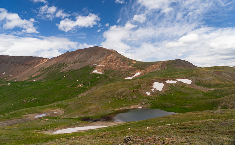
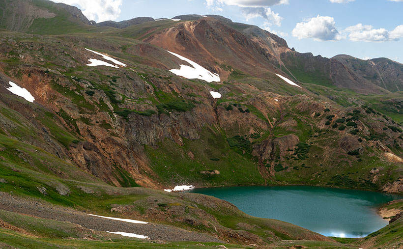
Lake Como – A little alpine lake from California Pass in Colorado’s San Juan Mountains.

Something is intoxicating about standing on a mountaintop. You get a sense of accomplishment—an incredible buzz—while taking in the view. As you spot familiar landmarks, the map you carry around in your mind gets updated. I can understand the addition mountain climbers have to the highest peaks. I’m just too lazy to be one of them, and you won’t catch me on the climbing wall at the local gym—or inside the gym in the first place. Spending a day with Fred driving his FJ up-high passes in the San Juan Mountains was good enough for me.

When we decided not to spend all day driving Colorado’s Alpine Loop but drove up two of its passes, we wanted another challenge. The first ascent was scary, while the second was not so much. I felt like a kid on a swing urging his parents to push harder. “Again,” I shouted. So, we stood on Engineer Pass with the map spread over the hood, looking for another route back to Silverton. After all, we didn’t want to go back down the way we came. That was along the Animas River and was flat and dull. We agreed on a route that would take us over two more passes before dropping back to Silverton via Cement Creek, and that meant that we’d have first to drive back down to Animas Forks.

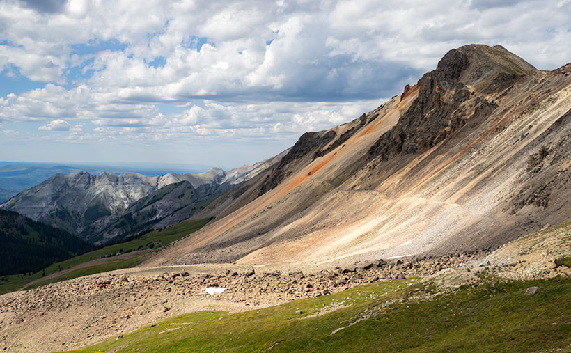
From the ghost town, we headed west up California Gulch. Going in this direction, the road ran straight ahead for several miles and appeared to end midway up California Mountain. Several times, I’ve traveled roads without a clue what’s ahead. For example, Interstate 15 is heading north out of Mesquite, Nevada. As it leads for the Beaver Mountains, you can’t pick out where the freeway climbs over them. I always involuntarily back out of the gas in case the road suddenly ends—like against the mountainside. At the very last moment, the Virgin River Gorge opens and swallows the highway. I was getting that feeling now.

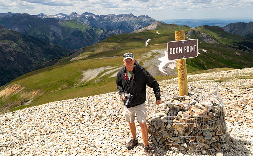
It wasn’t until the perceived end of the road that it turned on itself and climbed behind a side ridge that hid the route from below, and as we drove around the bend, the trail went vertical. I questioned our decision to go this way because this was undoubtedly the beginning of the roller coaster from hell. Fred managed to keep all four wheels on the ground while his truck grunted its way up the grade. When we reached the top, as with the other passes, there was a spot to park and look around. When I got out, I decided a box of Depends would be a handy accouterment on these trips.

But the view! The light was coming in, and there were great shots back at California Gulch, and in front was this pretty little alpine lake—Lake Como—on the other side. I have seen pictures of places like these in magazines, but I’ve never been to one. It was breathtaking—well, 13,000 feet is stunning enough, but you know what I mean. I snapped several variations of this photo, and we eventually drove down to the lake where Fred tried to park over an open mine shaft, but that’s another story. This week’s featured image is the version I liked best because of its composition and color details. I call it Lake Como. I hope you like it.

Don’t let your eyes miss out—feast them on an even grander version of Lake Como right here (Jim’s Page)! Buckle up because we’re diving back into Colorado’s enigmatic San Juan Mountains aboard Fred’s Toyota next week. Trust me, you won’t want to miss this!

Until next time — jw

Engineer Pass Picture of the Week

When my friend Fred planned our off-road excursions through the San Juan Mountains, his initial itinerary was to complete the Alpine Loop, which includes two passes, circling Red Cloud Peak, Sunshine Peak (which are two of Colorado’s 14,000 foot mountains, but aren’t even in the top 10), and a stop in Lake City. Now that I’ve had time to recover and look at my maps, I think that would be a fabulous trip, especially if we did it later this month when the aspens turn color. But, when we stopped at the Silverton information center, he was told that it’s a seven-hour trip, and it was already afternoon, so we decided to sample some of the passes around Animas Forks instead.

Last week’s image was from Cinnamon Pass, and this week’s picture is from Engineer Pass—our second stop. Both of these places are along the Alpine Loop. If you do Cinnamon first, the route will be counter-clockwise and the opposite direction if you first go over Engineering Pass. The two passes are only miles apart, and most of the Alpine Loop is east of them. Although they’re relatively close, as the crow flies, driving the road requires descending 3,000 feet to the ghost town then 3,000 feet back up the other way. If I thought going up the mountain was exciting, going down was harrowing. I almost got out and walked.

Mountain Man Fred
Mountain Man Fred – It’s not an illusion that Fred’s hanging on to that wire. The sign is well over the slope, and the footing is unsure because of the loose shale.

As we rounded a corner, we saw a knoll where several vehicles were parked, and a crowd snapping selfies and taking in the view. We assumed this was it. It wasn’t. It was Odom Point, and we joined the others for the view and document our visit. As we returned to the road, a sign that said that our pass was further down the road, so we drove another couple hundred yards.

Engineer Pass
Engineer Pass – Looking north from the saddle, you can see two mule trails blazed by prospectors. One leads down into the valley while the other zig-zags up the unnamed peak.

This week’s image that I call Engineer Pass was taken from the 12,800-foot high mountain saddle looking north, and it shows an unnamed peak that’s another hundred feet higher. Also visible are two mule trails, one that descends into the valley and the other that cuts across the talus slope past the red streaks before a switchback as it zig-zags to the summit. I declined to try either of the trails.

While we were taking in the view, I turned around and was stunned to spot over a dozen cyclists peddling up the grade from Palmetto Gulch. No way! We were driving a jeep, and I was out of breath, while these guys were racing mountain bikes on the same road. It’s no wonder that Stephan Pastis ridicules bicyclists in his syndicated cartoon Pearls Before Swine. They’re insane.

You can see a larger version Engineer Pass on its Web Page by clicking here. Be sure to come back next week when we’ll continue exploring Colorado’s San Juan Mountains in Fred’s Toyota.

Until next time — jw

Cinnamon Pass Picture of the Week

So, I cheated on September’s subject. By that I mean that Archie and I didn’t drive on these roads, they weren’t just casual side roads—you had to want to go on them, and they weren’t even in Arizona. Let me explain, and I’m sure you’ll forgive me.

August is the time for our annual retreat from the heat. By then we’re in the middle of the muggy monsoon, and we have to find respite in a cooler place—even if it’s Utah. This time we decided to spend a couple of weeks with our friends, the Poteets. Fred and Deb have been working as camp hosts in Colorado and Minnesota for several years, so we dragged The Ritz to cool off in the 6500’ mountain air of Durango.

When we got there, the first thing Fred wanted to do was “… hop in my FJ and drive over some of Colorado’s famous mountain passes.” I thought he meant driving some highway over the Continental divide, but nooo. He was talking about driving the prospector roads in the San Juan Mountains. He bought the Toyota earlier this year and hadn’t yet put it through its paces. He swears the FJ badge on it stands for Fred’s Jeep, and he wanted someone to go and test it on what barely passes for roads. Now I know what Deb meant when she pulled me aside on arrival and said, “Tag, you’re it.”

Our adventure centered on the ghost town of Animas Forks, which is a dozen miles northeast of Silverton and at over 11,000’. We spent an entire afternoon driving over mountain passes that would look down on Mount Humphries—the highest mountain peak in Arizona. The so-called roads were one-lane gravel mule trails cut into the mountainsides. They had impossible grades, and often, the windshield view was just clouded sky. Many times the gravel was replaced with bedrock and the truck would tip precariously—always to my side, and I’d be looking in horror over the edge, and I’d quote something that Queen Anne has said many times to me, “<imagine a woman’s voice screaming>.” Then there were the switchbacks. “We’ll have to turn around,” I’d suggest in a high squeaky voice. Fred would answer with, “Here, let me put it in low range,” then he’d push some lever, and the FJ would claw its way further up the hill.

In all, we spent four or five hours above 12,000 feet and crossing four passes. When you’re at that altitude, a 13,000-foot mountain isn’t so much, so we’d get out and climb on foot to its summit for a pee. I’m glad that Fred remembered to set the brake because, with my luck, we’d be standing on a mountain top watching his truck roll backward into the valley three thousand feet below.

After we got back into Silverton, we stopped so Fred could put air back into the tires. “20 pounds is the minimum to keep the tire from separating from the wheel, but the ride is better.” He then asked if I’d like to do more mountain four-wheelin’. After thinking for a moment, and being the manly man that I am, I told him, “Only if I can bring a box of Depends along so I can change my shorts.”

Cinnamon Pass
Cinnamon Pass crosses over the mountain of the same name at 12,640 ft. That’s well above the timberline in Colorado’s San Juan Mountains.

This week’s featured image was taken at the first of the four passes that we visited—Cinnamon Pass. When we got there, we got out, kicked at the dirt, and looked around with our hands in our pockets—it was cold up there. After shooting a couple of shots, I told Fred that I was going to climb up a roadside knoll to see if there was a better shot. On top, I found out there was because I saw the little alpine lake hidden from the road. As I hiked back down to the truck, I told Fred what I had found so he could see the pretty little lake.

You can see a larger version Cinnamon Pass on its Web Page by clicking here. Be sure to come back next week when we’ll show another photo from Fred and Jim’s exciting mountain outing.

Until next time — jw

Four Ponderosa Picture of the Week

When an Arizonan talks about a pine tree, the red barked ponderosa is most likely what they’re referencing. It’s the common pine tree in Arizona. We have so many of them that our grove grows like a slash across the state’s middle, like a belt, and they continue east into New Mexico. It’s the world’s longest contiguous ponderosa forest in the U.S. Sadly, some of our brightest citizens try to burn them all down each fire season.

It’s a happy tree for me because it means that I’m in the high country when they’re around. Most likely, I’ve traveled to escape the desert heat and spend some time in the shade of the tall pines napping with a bit of fishing line tied around my toe. I have a fond memory of getting up early on a fall morning to drive up to Hawley Lake, and as the sun came up, we were on the Rim Road. The morning sunlight flickered between the tall trees, and I felt like I was driving through the Black Forest in Germany. Although I’ve driven that road hundreds of times since then, I’ve never had the same feeling.

Four Ponderosa
Four Ponderosa – Growing in a grouping that reminded me of a four-poster bed. Maybe I thought that after my long hike and I was tired (and don’t forget, tired).

During my visit to the Hualapai Range outside of Kingman, I was surprised to see ponderosa growing. In the Desert Southwest, they only grow at higher elevations. On the road, I rely on the trees to estimate my height. First, come the pinion pine at around 5,500’, then the ponderosa starts at 6,500’, and then the aspen show up at over 7,500’. The mountain island on top of the Hualapai’s probably is most likely the western edge of our grove. Only the Black Mountains are west of here, and they’re not high enough to support the big trees.

I walked by the ponderosa’s in this weeks image on my way back to Archie after a hike up the mountain. My legs were already sore, and this four-tree grouping reminded me of a four-poster bed. The spacing between them was ideal for hanging a hammock. It’s a good thing I don’t carry one because I would have spent the night, or even worse, I would have rolled over and fallen out onto the ground. That would be just my luck.

I call this week’s image Four Ponderosa, and you can see a larger version of it on its Web Page by clicking here. Be sure to come back next week when we show another photograph from the Hualapai Mountains.

Until next time — jw

Dean Peak Picture of the Week

Dean Peak
Dean Peak – One of several points in the Hualapais over 7,000′. I captured this as the sun was setting and the rest of the mountain was in shade.

There’s a Prime Video series Queen Anne, and I watched this month called Good Omens. We enjoyed it so much that we watched it a second time, and caught a lot of the subtler jokes that we missed the first time. The main characters—an angel and his demon buddy—aren’t very good at their jobs, and consequently, they screw up Armageddon. This riddle was in an episode, “How many angels can dance on the head of a pin?” It’s a trick question because as God—the voice of Frances McDormand—explains; Angels don’t dance, that’s something the devil conjured, and there’s not a substantial enough number to count them all, because demons can line-dance in the spaces between the pin’s atoms—funny stuff. When I visited this month’s photo location, I thought about the show’s riddle.

For my August pictures, I only had to walk across the street—as such. My new subject is the mountain range on the west side of the Big Sandy River and U.S. Highway 93—the Hualapai Range. They’re part of the parallel mountain ranges making the Basin and Range Domain which runs from Utah to the California Sierras. From space, these formations look like a pack of caterpillars stampeding across a sidewalk.

The Hualapai’s are a twin to last month’s Aquarius Mountains, except they are high enough—7,000 to 8,400—for pinion and ponderosa pine to grow. That means they are often snow-covered in winter. They fill the area between Wikiup and Kingman.

When my folks lived in Kingman, I heard of a park up on the mountain, but never visited, so last week I loaded Archie and drove up Sawmill Canyon Road (alas, if there was a sawmill, it’s gone now). The DW Ranch Road exit on Interstate 40 is a handy shortcut to use if you’re coming from the valley. It’s less than 10 miles from the Interstate to the County Park which is situated in a tiny valley at the top, and where Kingman residents have packed summer cabins into every available space. As I drove along the deeply rutted streets, I wondered, “How many Ford executives can camp on the top of Hualapai Peak?” In the village’s center, there is a concrete catch basin that’s called Pine Lake, but I couldn’t find public access to it, and—from its color—I’m not sure you would want access anyway. I got frustrated at having to back out of each street I tried and decided to check out the Hualapai Mountain Park and campgrounds.

After paying a day fee, I parked in the trailhead parking lot and checked out the maps. It was already after five when I started on the path to Stair Step Overlook, about a half-mile hike. I was never athletic, and I don’t claim to be in great shape today. I grew up uncoordinated, and when I was a kid, I was always the last pick for team sports. But, I regularly walk now, and my average speed is over two miles an hour. I figured a 15-minute walk at the most, so I grabbed my camera and left my water in the truck. I was wrong. It took 10 minutes—coming back down the mountain. The trail climbed four-hundred feet in that half-mile. As I hiked, I followed a group of two men and a woman who were in their early thirties and equipped with day-packs. I followed them inch-worm style; they walked out of my sight and then they’d be resting when I caught up.

When I finally got to the overlook, my new hiking friends were lounging on large granite slabs and taking in the view. As I climbed up the stairs, I looked up to see six of them before my eyes could focus again. The woman looked concerned and asked, “Do you need water?”

“No,” I replied. “I only wanted to get here and take some pictures. I’m going back down right after that.”

Then the guy with the beard drove a stake through my heart, “Man! I hope that I can be hiking up and down some mountainside when I get as old as you are.”

I did get a shot from the overlook, but I took this week’s featured image on the drive home. I call it Dean Peak because that’s what this point’s name is. When I took this shot, the sun was almost down, and the lower part of the mountain was already in the shade. I hope you enjoy viewing it.

You can see a larger version of Dean Peak on its Web Page by clicking here. Be sure to come back next week when we’ll be showing more from the Hualapai Mountains.

Until next time — jw

Mohan Range Picture of the Week

Have you ever looked at an Arizona road map and noticed the large chunks of unpopulated areas? It seems like the western third of the state is deserted. Most of the time there’s a good reason no one lives there and maps that show the land ownership quickly show why. For example, the military uses much of the land between Interstate 8 and the Mexican Border for bombing practice—what better use of a desert is there? Most of the area north of Interstate 40 and Utah is either the Grand Canyon or tribal land. The western third of Arizona is lower Sonoran or Mohave desert, and it gets a lot less rain than the rest of the state.

Then there’s Arizona’s Bermuda Triangle. Three highways define its legs: U.S. 93 on the west, Interstate 40 on the north and its eastern boundary is Arizona 89. The land included here isn’t desert wasteland; it ranges in elevation from 3-6 thousand feet. It’s transitional grassland, about the same as Prescott Valley. As I look out my window, I see thunderheads developing in that direction—as they do on most monsoon afternoons, so it gets seasonal rain. Why are there no settlements up there?

As I wrote in last week’s post, this month’s area of exploration is the Aquarius Mountains, and my first journey into them was via Upper Trout Creek Road. It’s a short loop road that intersects with Bogles Ranch Road which my map incorrectly identifies. It climbs to a pass and down the far side. At the top, there’s a religious retreat with a parking area wide enough to stop, take in the view, and then turn around, just like I did when I took this week’s featured image called Mohan Range.

Mohan Range-Very few know or have visited the Mohan Mountains in Arizona.
Named for one of General Cook’s Indian scouts, the Mohan Range is seldom visited.

I had never seen or heard about the Mohan Mountains before because as you travel US 93, the Aquarius Range hides them. At one foot shy of 7500’, Mohan Peak is substantial—one of the top 100. I’ve learned since that you can see it in the distance on Interstate 40 and from higher Prescott elevations. As is my way of doing things, I wanted to learn more about these mountains, so when I got back to my office, I hit Google pretty hard. This time I found a goldmine.

The first referral that came back was on a Peakbaggers page. These are people who—for no good reason—like to climb the top 100 mountains in each state (I have no idea what the do in Florida). It’s very informative, well written, and has photos of their expedition. It had a link to a second Webpage written by Kathy McCraine, which has even better photography along with her story of the O-RO ranch.

So why aren’t there any settlements here? Because this land—all quarter million acres of it—is the O-RO ranch (no Dr. Carson, it’s not a cookie). The ranch’s east half started with the Baca Land Float #5. That’s right, one of the authentic Spanish land grants honored by the US Government. According to her story, the original owners merged with a second parcel on its west side­—The Mohan Ranch—to create the most significant and oldest cattle ranch in Arizona. It’s run the same as it always was, cowboys on horses rounding up cattle and sleeping in tee-pees. With no town’s or roads, it a hard life and as Kathy tells it (I love this line), “Cowboy wannabe’s need not apply.” The ranch does not welcome visitors and if you’re the area, you best heed of the warning signs.   

You can see a larger version of Mohan Range on its Web Page by clicking here. Be sure to come back next week when we set off for another adventure exploring Arizona’s back roads.

Until next time — jw

Aquarius Boulders Picture of the Week

Long before Arizona was a state, it belonged to another country—Mexico. In retaliation to the Alamo massacre, the U.S. declared war on our southern neighbor and took away half of their land. When Mexico surrendered, we tossed fifteen million dollars (the same amount as the Louisiana Purchase) on the bed and said, “The money’s for the room, babe.” Our newest land acquisition was called New Mexico Territory, but—because it was so vast—we split it into several states. Arizona was the last to make the team.

To see what their money got, cigar-chomping Washington politicians handed some change to a young lieutenant—Amiel Weeks Whipple—then told him, “Here, kid. Grab a couple of guys, a tape measure, and measure the backyard.” This expedition was Lt. Whipple’s first across our state. He started in San Diego and headed east, surveying land along the new border. His second journey was in the other direction, and this time, he was to lay out a railroad route along the 35th Parallel—Interstate 40.

I mention Lt. Whipple because, when I research how an Arizona location got its name, it is often cited in Arizona Place Names—that’s the reference I usually use. As he worked his way across the territory, surveying, mapping, and fighting Apaches, Whipple didn’t have the luxury of stopping someone to ask, “Excuse me, but what do you call those mountains?” Not many people lived here, and many who did were cranky. After all, air conditioning hadn’t been invented yet. Instead, if a place needed a name, he’d make something up that seemed to fit.

That’s precisely how the Aquarius Mountains got their name. Whipple, who found abundant water sources in the range, named them after the mythological water bearer. If you’ve driven to Kingman, you’ve passed by the Aquarius Range. They are on the east side of U.S. Highway 93 from Wikiup north to almost Interstate 40. The highest peak is Snow Mountain, with an elevation of 5880′, so it sometimes has snow. Several dirt roads go up into the range, which will be the routes we’ll scout for exciting photographs. We will be spending the month of July photographing along the Aquarius’s back roads.

The first road I’ve always wanted to follow has perplexed me since I drove U.S. 93—Upper Trout Creek Road. I mean, give me a break, this is the Upper Sonoran Desert (the transition zone), how can there be a creek cold enough to support trout? It doesn’t, or at least not this particular Trout Creek. This one is a tributary of the Big Sandy River. As soon as the road crosses the Big Sandy, it’s called something else according to Archie’s navigation system (but not on the Gazetteer). I drove the road to the ridge, where I was treated to a beautiful vista to the east.

Aquarius Boulders
Aquarius Boulders – With the sun setting over the Hualapai’s, the rocks, trees, and sky are bathed in a warm glow.

This week’s image is from Granite Flat, halfway up the mountainside. When I stopped, the sun was going down behind the Hualapai Range (on the west side of Highway 93), and its rays cast a warm glow on the rocks, peaks, and low clouds hovering in the sky. I call this shot Aquarius Boulders. It’s a scene looking north with Hwy 93 in the valley to the left and the Aquarius peaks to the right.

You can see a larger version of Aquarius Boulders on its Web Page by clicking here. Be sure to return next week when we set off for another adventure exploring Arizona’s back roads.

Until next time — jw