
My process for choosing new shooting locations involves endless map searching and YouTube videos. When I find a new spot on the map, I watch videos of the area to determine if I can get there—and, more importantly, safely return. A few years ago, I considered an excursion into the relatively new Grand Canyon-Parashant National Monument in the northwest corner of our state. Few photographers have been there, so it should be ripe for the picking. Alas, I determined that my SUV wasn’t ready for prime time.
However, I did find a spot along the way that looked promising and on a paved road. Whitney Pockets is located in our newest National Monument—Gold Butte. The only access to it is from Mesquite, Nevada. Over the past couple of years, I’ve unsuccessfully tried to get it on our schedule. Gold Butte is a remote part of Nevada wedged between the Overton Arm of Lake Mead and Arizona. Apart from the entrance, it has no paved roads, campsites, gas stations, restaurants, or cell phone coverage. The monument’s target audience is four-wheelers seeking wilderness solitude without hiking—my kind of people.
In October, Anne and I finally made our first trip into Gold Butte and shot the Whitney Pocket area at the pavement’s end. It’s our December photo project, and I think it’s an excellent way to end the year.
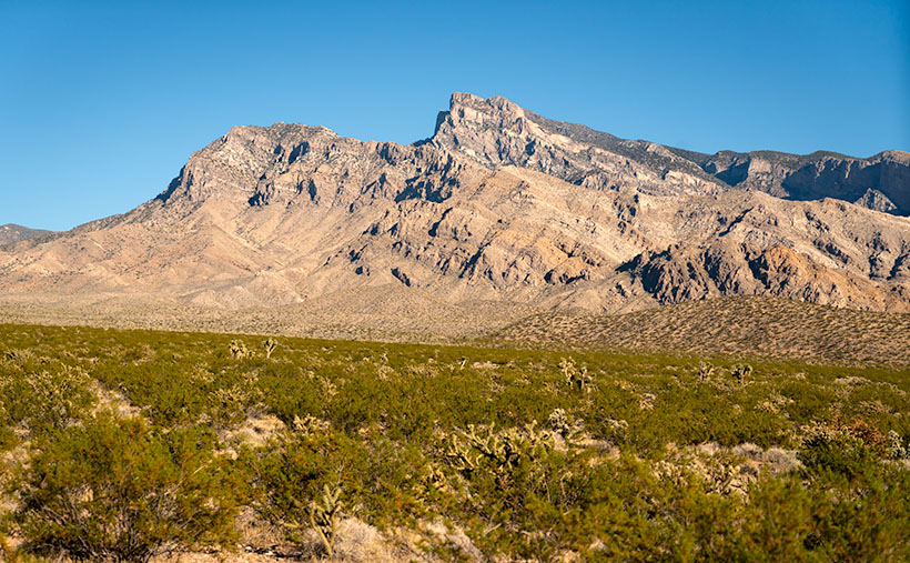
Whitney Pocket was so compelling for us to visit because it’s in the pristine Mohave Desert with outcrops of the same sandstone foundations in Zion National Park and Southern Utah. You can see the monument from your Mesquite hotel room, but to visit, you must drive around the west side of the 8,075′ Virgin Peak—the mountain you see south of the river. The drive from the bridge crossing the Virgin River is an hour or 22 miles on bad pavement. Never before have I had to air-down the tires for tarmac. Trust me, if you try going faster, your kidneys will bleed, and you’ll constantly be stopping to pick up falling parts. The road was mysteriously constructed in the 30’s and hasn’t been maintained since. I’m sure some of those pot-holes are as old as the road.
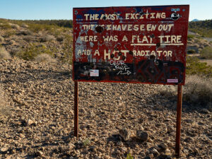
Whitney Pocket has broad-level areas that are good for trailer parking. There are a couple of port-a-potties in the space, but nothing else. Just you, the rocks, the Mohave Desert, and stars—there are so many stars, even with the Las Vegas light pollution on the western horizon. You’re out of luck if you want a map or something from the gift shop. They’re back in town at the visitor’s center.
If you’re into human history, this isn’t the place to be. It’s so remote the Army used it to test the worthiness of its desert vehicles. None other than General Dwight D. Eisenhower led an expedition across this part of the Mohave desert between the World Wars. The remains of his tracks are one of the side roads you pass along the way to Whitney Pocket.
A few petroglyph panels are found inside the monument that originated with the Fremont people of central Utah. The most famous one is the Falling Man panel because it’s an uncommon depiction. Don’t look for them on the maps, but several people have directions online. The Bureau of Land Management would prefer them to be undamaged, so the fewer people visiting them, the safer they are.
An old mine town, appropriately called Gold Butte, is at the south end of the monument. Oddly enough, it got its name from the nearby butte of the same name. They say that only the foundations are left. Besides that boom town, few souls have tried prospecting or cattle ranching here. Among them, a legend grew around Howard Hughes, the enigmatic tycoon rumored to have orchestrated the construction of the road into the region—allegedly overnight—in the 1930s.
The designation of Gold Butte as a National Monument was the culmination of a two-year campaign led by local conservation groups, Nevada and Clark County lawmakers, and the Moapa Band of Paiute Indians. This concerted effort resulted in President Obama designating the area as a national monument under the Antiquities Act on December 28, 2016. The designation, which occurred on the same day as the designation of Bears Ears National Monument, was also strongly supported by U.S. Representative Dina Titus and outgoing U.S. Senator Harry Reid, as well as the Las Vegas Paiute Tribe
As I said, this was our first venture into Gold Butte, and I can’t wait to return. But since access to the rest of the monument is over rock-covered roads and through dry washes, it will have to wait until I buy proper off-road tires for the Turd. Maybe this spring, after the winter rains bring out the spring wildflowers. Consider joining us if you’re into solitude and grit in your teeth.
I hope you enjoyed our introduction to Gold Butte and Whitney Pocket. Be sure to stop by each Sunday this month (after you get home from your Christmas shopping). I have more pictures to show and stories to tell. If you’d like to see a larger version of Virgin Peak (I almost called it Madonna—you know, ♪ like a Virgin ♬—but Queen Anne thought that was silly), you can see it on my website < Jim’s Web Page> or its FAA page <FAA Link>.
Till next time, keep your spirits high and your humor dry.
Jw
Now I know why you went to Mesquite Nevada. Are we going to see a photo of Falling Man in the future?
I had wondered how you picked your locations – interesting.
Can your drone go where the Turd can’t?
So many questions. Not all of the places that I go to require a lot of research. Like Bisbee for example. We hadn’t visited in years and I knew what to expect, so we just packed up and went. But with places new to us, I like to know what I’m getting into. Fred’s FJ would be overkill for Gold Butte, and I’d feel comfortable using it in the Grand Canyon-Parashant National Monument. But the Turd needs that body-builder powder to stop bullies from kicking sand in his eyes and taking away his girlfriend. Poor Turd.
The drone is a handy tool, but only has a range of three miles (radio communications) and the battery is dead when it returns home. There are two other issues with the drone that are FAA requirements. The first is that someone has to have an eye on it at all times, so you can’t sail it over the horizon. The other issue is that you can’t fly a drone in a National Park, Wildlife Reserve, National Monument, and most state parks. Gold Butte is a National Monument, but is managed by the BLM – not the Park Service. So, there are unresolved questions as to whether I can fly there or not. A violation of either rule can result in a fine and a loss of my license. – jw