I Didn’t Set Out to Solve a Mystery. I Just Wanted to See the Rocks.
Some people are drawn to ghost towns. Others chase old roads or abandoned buildings. Me? I follow the rocks.
Rock formations of any kind are my kryptonite. I can’t resist them—especially when human hands have arranged them in some message, symbol, or cosmic doodle. Maybe it’s the geometry. Perhaps it’s the mystery. Maybe I was just dropped on my head near a petroglyph as a child.
Over the years, we’ve chased plenty of these:
-
- The Blythe Intaglios, massive geoglyphs scratched into the desert crust near the Colorado River.
- The stone maze in Palm Canyon, deep in the Kofas, where someone went full Minotaur without leaving a forwarding address.
- A hidden plaza beneath Dome Rock, where a dedicated boondocker has spent years—maybe decades—rearranging flat stones into a labyrinthine camp patio, complete with walls, paths, and what we think was a meditation corner (or perhaps a solar oven).
So when I saw a video that casually mentioned “rock art” outside of Sundad, I was already halfway in the car. Another mystery. Another pattern in the dust. Another chance to squint at the desert and wonder what kind of mind says, “Yeah, this is a good place for a star made of gravel.”
What I didn’t expect was a full-blown investigation—one that involved half-buried relics, bad land deals, maybe a smuggling ring, and the only known resident ever to leave town after everyone else.
I didn’t set out to solve a mystery. I just wanted to see the rocks.
But when Clouseau and Watson (the Costco version) hit the backroads of Arizona, there’s always a case to crack—even if it’s made entirely of basalt and lies.
That’s when the detective hats came out. Figuratively, anyway.
Anne donned her travel tiara—a double-sided unit with built-in ear flaps adorned with diamonds, because she insists they improve reception. I tied my shoes (eventually), and we declared ourselves ready for fieldwork. The Case of the Stone Circles had officially begun.
I may have had the obsession with rock formations, but Anne, true to her Watson role, has the gift of noticing what others ignore. Where I charge in looking for the weird and the wonderful, she’s the one who points out the thing that’s been right in front of us all along. She doesn’t try to solve mysteries; she just quietly sees them forming. Which, come to think of it, is precisely what a good detective—and a better travel companion—does.
The Drive Out – In Which We Pursue the Phantom Town
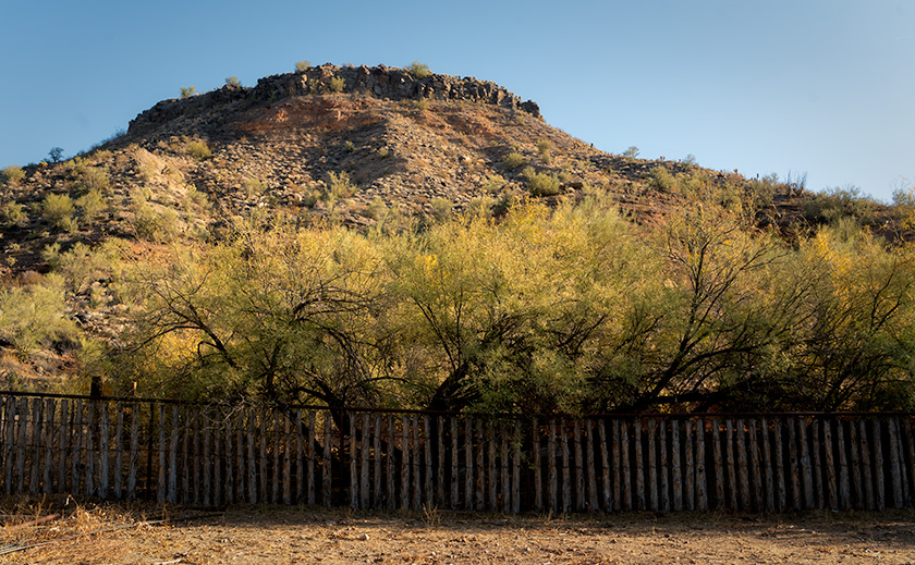
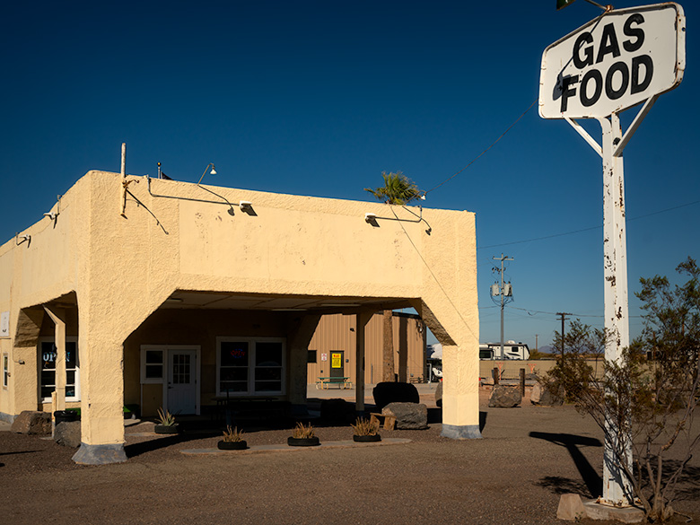
If you were trying to pick a spot in Maricopa County that felt as far from civilization as legally allowed, you’d probably land at Sundad. It’s pinned like a forgotten thumbtack between I-10 and I-8—right where your cell signal dies of thirst and your GPS gives up and asks if you’ve considered turning back.
I had braced for an all-day slog over jagged mining roads—visions of rock gardens, tire-piercing shale, and the Turd’s new backroad treads earning their keep. I even pre-warned Queen Anne that lunch might consist of a warm protein bar and a view of the tow truck.
But the Agua Caliente–Arlington Road turned out to be a dirt expressway—broad, smooth, and graded like the county grader just needed something to do. Anne’s “gutless wonder” could’ve floated down it like a shopping cart in neutral. We didn’t pass a soul on the way in, and I suspect we doubled the traffic count for the year just by showing up.
Eventually, though, the express lane ends, and the real Sundad begins. If you want to see what’s left of the town—or at least its artistic ambitions—you’ll need a high-clearance vehicle, four-wheel drive, or a good pair of Merrells for the final mile and a quarter.
I chose the first option. Anne chose sarcasm.
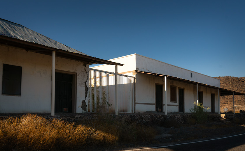
Exhibit A: The Desert Sanatorium That Wasn’t
According to Arizona Place Names, Sundad was “once proposed as a desert sanatorium.” That’s it. That’s the entry. No dates, no founders, no grand opening ceremonies. Just a vague proposal and a note that “the origin of the name has not yet been ascertained.”
Which is fair, because the origin of the town hasn’t been ascertained either.
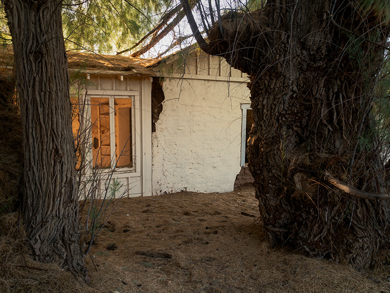
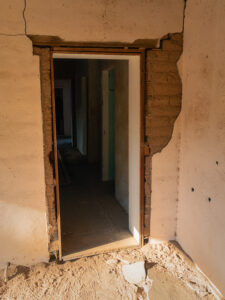
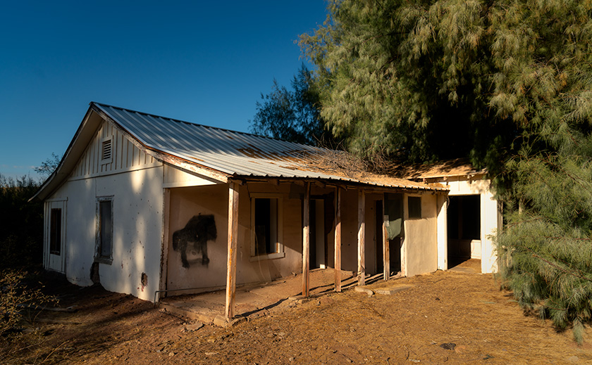
If there was ever a medical facility here, it left no trace. No plumbing. No foundation. No ruins—unless you count the rusty bedframe half-buried in gravel, which may have belonged to a patient or a prospector, depending on how optimistic you’re feeling. …And yet… there is a large metal tank at the townsite, tipped on its side like a fallen silo. It looks like the kind of water tank you’d use to feed a well—or at least the kind you’d bring in if you were pretending to have a well. It’s the first piece of evidence that suggests someone made an honest attempt, however half-hearted.
Still, building a desert sanatorium without reliable water is like opening a hospital with no bandages. It’s possible someone tried. It’s just as likely that someone merely talked about trying and hoped the desert would do the rest.
The real TB sanatoriums in Arizona—Sunnyslope, Papago Park, Oracle—had infrastructure, funding, and staff. Sundad had… potential. Or maybe just the silence to dream out loud before the sun cooked the idea into vapor.
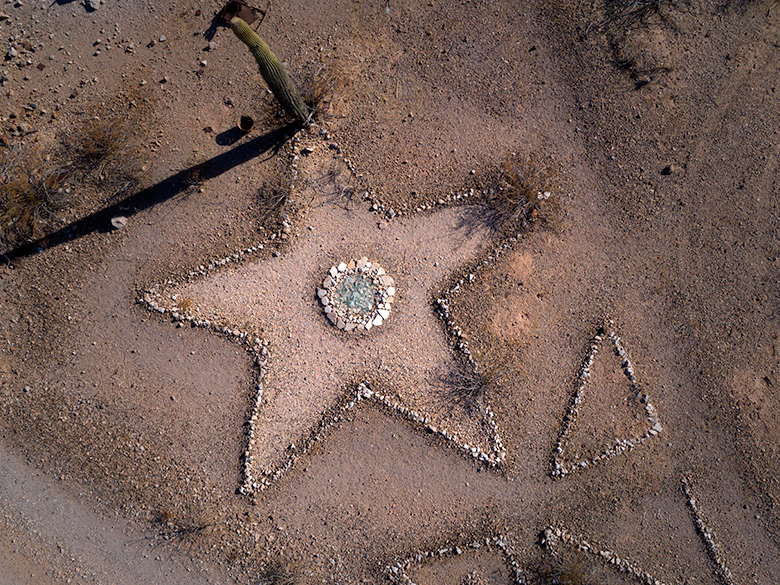
Exhibit B: The Health Spa Without Water
After the sanatorium idea dried up—likely before it even got wet—someone must’ve decided Sundad needed a new pitch. Enter: Stanley J. Pickleton (we changed the names to protect the guilty), land promoter, wellness visionary, and enthusiastic liar.
We have no formal record of Stan, but you can feel his presence. This has all the hallmarks of his era: promises of curative mineral waters, vague maps with dashed-line access roads, and the kind of flyer that uses too many exclamation points and phrases like limited investment opportunity!!
According to lore, an ad in the Tucson Newspaper (and possibly wishful thinking), Sundad was once marketed as a mineral spa paradise—a bubbling fountain of wellness tucked into the warm embrace of the Arizona desert. Never mind that the only moisture here is the condensation on your water bottle. There’s no spring, no stream, no oasis—just sand, gravel, and a metal tank that may have once held hope—or diesel.
Nearby Agua Caliente, once a real hot spring resort, has since dried up. That, at least, had a reason to exist. Sundad feels like it was built on the reputation of having heard about Agua Caliente once at a bar.
But this didn’t stop Stan. I imagine his pitch went something like:
“You there—yes, you! Are you tired of city smog? Chronic fatigue? Excess bone marrow? Come to Sundad, where the air is dry, the scenery is rustic, and the mineral content of the sand is second to none!”
He probably sold ten plots to a dentist in Des Moines and a preacher from Dubuque before moving on to his next venture—possibly underwater cactus farming.
Like the sanatorium, the mineral spa left no trace but rumor and rust. Still, in a place like Sundad, even a ghost of an idea leaves a shadow. Don’t get me wrong, there’s plenty of mineral water out here, but it’s instant. Just scoop up a glassful from the wash bottom—and add water.
Exhibit C: Mining or Misinformation?
Great mining towns all have one thing in common: minerals worth mining. But the great ones also have something even more valuable—something rare, precious, and not found in abundance at Sundad.
Water.
Need we say more?
There was mining here. You’ll find a few old shafts, collapsed timbers, and rusted cans scattered around the perimeter like leftovers from an abandoned science fair project. However, none of the mines are deep, none of the tailings are impressive, and none of the known claims have ever recorded actual ore being processed.
This wasn’t a bonanza. It was a maybe.
When I was a kid, I watched The Lone Ranger—and yes, I’m old enough to admit that without irony. In one episode, a couple of smooth-talking swindlers fired gold bullets into a cave wall, then tried to sell the claim as the next great strike. That kind of stunt may sound ridiculous, but it’s not far off from how most desert mining towns began—or ended.
For the record, the average prospector in Arizona found just enough gold to make one bullet. Maybe two, if he didn’t eat much. Which makes you wonder how many bullets were found in Sundad’s rock walls.
So yes, there was mining here. But it wasn’t serious. It was more like someone tried to look serious long enough to convince someone else to buy in and dig deeper. Like everything else in Sundad, the idea of mining here had just enough surface detail to keep the dream alive—but not enough depth to make it real.
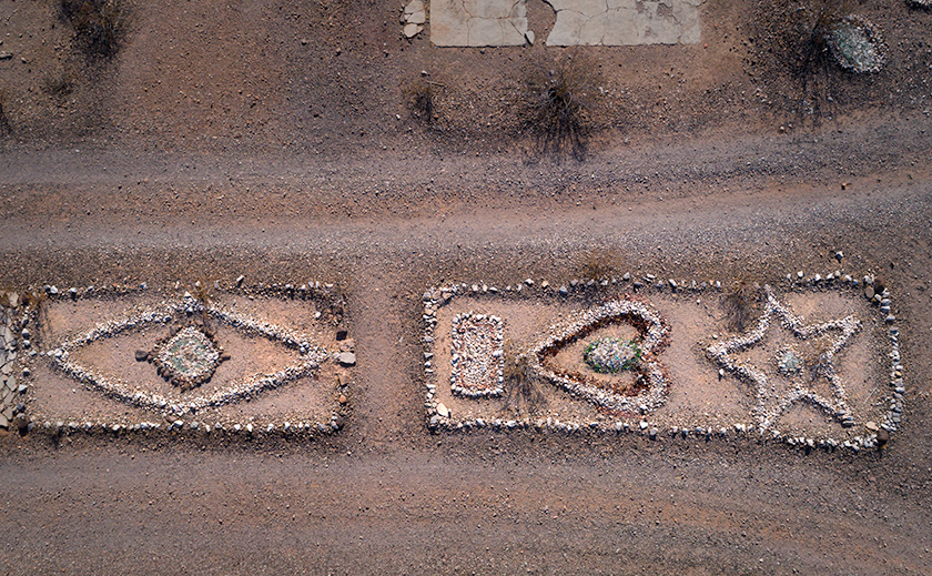
Exhibit D: The Widow Who Waited
For all the wild theories Sundad inspires—spas, communes, and questionable mining operations—only one story is confirmed to have happened here. And it’s stranger for being so unadorned.
In 1966, Velma and Lee Bailey—aged 58 and 77—were the only known full-time residents of Sundad. Retired. Living in a one-room mining shack. No phone. No neighbors. Not a whole lot of exit strategy.
On November 30th, Lee died. Velma, crippled and alone, couldn’t drive the car for help. So she did what anyone in her situation might do: she stayed put and started keeping an hourly diary. She kept his face covered with a cloth, scattered white fabric outside the shack in hopes a passing airplane would spot her, and waited for six days.
When a friend finally came to check on them, she was still there—the last living soul in Sundad.
And that’s what makes her story stand out: not because it’s tragic, or even mysterious. But because it’s provably real. In a town filled with speculation and rust, Velma Bailey happened. She’s the footnote every other theory tries and fails to become.
Why they chose Sundad for retirement is anyone’s guess. Maybe Lee had a lust for gold, or perhaps they just wanted to be left alone. However, it raises an essential geological point: the area is mostly basalt, not granite—meaning gold wasn’t exactly in abundance here, which makes you wonder if Lee was chasing riches, or just chasing the idea of being a prospector in a place nobody else wanted.
Either way, when Velma finally left, she did something no one else ever managed in Sundad: she turned out the lights.
Exhibit E: Commune of Confusion
After Velma, the shack door was left swinging in the desert breeze. The wind whistled through the cracks, but there was no one left to hear it. Sundad stood empty… for a while.
Then came the Age of Aquarius. Love children were turning off, tuning in, and dropping out. And according to local rumor, some of them dropped into Sundad.
Supposedly, a commune of free spirits moved in to build their desert Nirvana. But even the rumors seem half-hearted, like they were started by someone who wanted to believe the desert still had a use, any use.
Hippies, for the record, had a preferred fleet: converted yellow school buses, sun-bleached VW vans, and Dodge A100s painted with peace signs and daisies. None of which were known for off-road prowess or gas mileage. If you needed groceries, your options were Buckeye, Gila Bend, Yuma, or Blythe—all a hundred miles of rutted road away. And then you had to make it back before your bean sprouts wilted.
As for farming their food? Without groundwater, the only thing you could realistically grow out here was thirsty. There’s no trace of crops—unless they were cultivating spiritual enlightenment. And no signs of livestock unless you count lizards.
Even the foraging options would’ve made Euell Gibbons gag. You can’t live on creosote and mesquite pods unless you’re trying to commune with the emergency room.
So maybe a few wanderers tried it. Maybe they strung up a hammock, stared at the stars, and wrote bad poetry. But if anyone came here to drop out, they dropped right back out as soon as the thermometer hit 110.
If Sundad ever hosted a commune, it didn’t survive its first summer.
Enlightenment needs shade.
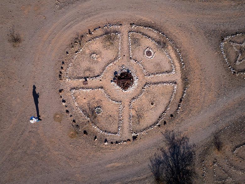
Exhibit G: The Smugglers’ Signature
Let’s take a step back and reexamine the scene.
Sundad is remote—even by Arizona standards. It sits squarely in the middle of nowhere, on public land, far from anything resembling oversight. No ranger station. No historical designation. No fences. Just silence, sun, and speculation.
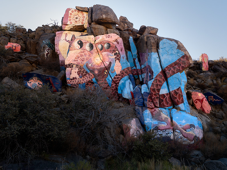
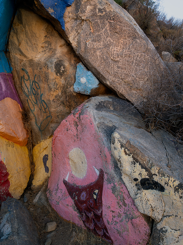
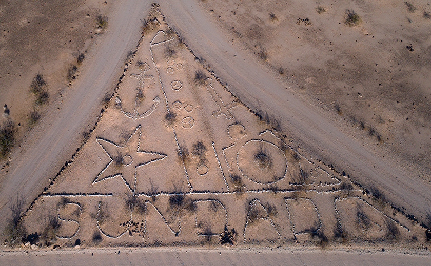
And yet, the rock art here is oddly meticulous.
Stars, diamonds, arrows, and one enormous circle filled with rusted metal—all laid out with deliberate care. But here’s the twist: these shapes aren’t made to be seen from the ground. They’re aerial designs—high contrast, pale on dark, clearly visible from above.
I was standing at the base of the giant arrow, scanning the horizon like an amateur archaeologist with a directional fetish. It pointed due south—across a stretch of flat nothing—and I saw… well, nothing. Just more gravel. More brush. More questions.
That’s when Anne, standing a few steps behind, shaded her eyes and said,
“What’s that orange thing over there?”
I turned. And there it was—a windsock.
Not old. Not sun-faded. Bright orange—vivid enough to catch her eye and fresh enough to make the whole setup feel suddenly… active.
Mounted on a solitary pipe, fluttering in the breeze, like a signal waiting to be read.
I had missed it completely. She saw it instantly.
That should’ve been the clue. But it gets better. Pull back on Google Earth, and suddenly it becomes obvious—though you could walk across it in person and never think twice. A long, straight strip of desert, running north–south through the center of town, has been subtly but deliberately cleared of large rocks. It’s not a cattle trail. It’s not a mining road—just a narrow corridor, flat and open—a homemade runway.
Crude, yes. But serviceable—for a Piper Cub, helicopter, or ultralight. And in today’s world, you don’t even need a Piper Cub. A drone could do the job—quiet, fast, and invisible from the road. The rock markers are large enough to be spotted from altitude, and the windsock confirms wind direction without requiring a human on the ground. It’s as if the whole setup was designed for someone to find… but not everyone.
A plane could land, unload, and take off—all without passing a house, a ranger station, or a single “No Trespassing” sign. And when it’s done, the rock shapes are still there, ready to guide the next flight in.
And here’s the kicker: no one talks about this.
The rock formations aren’t listed in travel guides. No historical society is trying to preserve them. The authorities aren’t investigating, and the off-road crowd hasn’t chewed them up. They’re undisturbed, unacknowledged, and unofficial.
These aren’t ancient symbols left by long-forgotten tribes. They aren’t folk art from the 1930s. They’re new. Recent. Maybe even 21st-century.
So, if they’re not historical, recreational, or artistic, then what exactly are they?
I’m not saying this was a smuggling airstrip.
But I am saying: if you were going to build one, this is precisely how you’d do it.
Closing Arguments: Who Made the Art?
We came to Sundad to see a ghost town, but instead we found a puzzle made of rocks—stars, diamonds, arrows, and a giant rust-filled circle that anchors the whole site like a sundial built by conspirators or desert poets.
Who made it?
Was it the hippies, laying out cosmic symbols in the dust before their tie-dye melted in the July heat?
Was it boondocking RV’ers, rearranging gravel between solar power checks and sunstroke naps?
Was it aliens, communicating in geometry because they couldn’t get a cell signal either?
Or was it something else? Something more deliberate?
The arrows don’t just point randomly. The wind sock doesn’t hang itself. The runway doesn’t clear its own rocks. It’s all too quiet, too intentional, and—most tellingly—too modern to be folklore.
We don’t know who built it. But we know this: somebody wanted to be seen from the air… and just as easily forgotten on the ground.
And maybe that’s why we came. To find the mystery. To walk the question mark. To leave just enough footprints so the next person knows they’re not the only one who saw it.
Who made the art?
Perhaps the better question is: Who will add to it next?
Personal Reflection / Backroad Philosophy
The backroads don’t always lead to answers. Sometimes they don’t even lead to destinations. But if you pay attention—really pay attention—they often lead to something better: questions worth asking.
Sundad isn’t a ghost town in the usual sense. There were no saloons, no shootouts, no bustling main street slowly fading into history. It never lived long enough to die. Instead, it’s a place built from attempts—a town-shaped shadow of ideas that never quite took root.
A sanatorium without patients. A spa without water. A mine without gold. A commune without crops. And yet, here it still is, marked with symbols someone thought worth laying in stone.
In that way, maybe Sundad wasn’t a town at all.
Maybe it was a mirror—reflecting whatever dream the visitor brought with them: health, wealth, escape, or purpose. If you’re looking for answers, you’ll leave frustrated. But if you’re looking for meaning, you might find just enough scattered across the gravel to spark something.
That’s the art of travel on the backroads: knowing that not every journey needs a conclusion. Sometimes it’s the wandering that sharpens the eye, the silence that tunes the ear. And in places like Sundad, the ones you’ve never heard of, that’s where the real connoisseurs begin to notice the difference between empty and unfinished.
Call to Action: Your Turn, Detective
So what do you think?
Who made the art? Was it a commune? A cartel? A clever retiree with a surplus of rocks and time? The desert’s not saying—but you’re welcome to weigh in.
Drop your theory in the comments. Have you stumbled across a place like Sundad—quiet, forgotten, and full of questions? We want to hear about it.
Arizona’s backroads are stitched with stories that never made the brochures. Ghost towns without ghosts. Towns that never were. And if you’re willing to wander a little off the map, you’ll find them—layered with dust, sun-bleached history, and the occasional conspiracy.
Just remember: explore with respect, leave no trace, and take only pictures. And if you’re struck by the urge to rearrange rocks into cosmic symbols—maybe pick up a patio kit from Lowe’s instead.
The desert has enough mysteries already.
See you on the next trail.
jw