Arlington’s Abandoned Feed Mill: Fading Memories of Cattle Country Picture of the Week - Arlington, Arizona

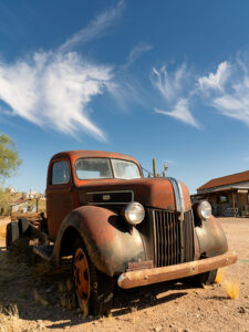
Abandoned farm equipment at Arlington Cattle Company
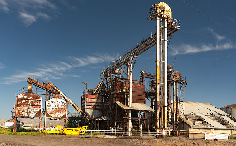
Arlington’s Abandoned Feed Mill – The abandoned grain hoppers and silos of the Arlington Cattle Company were left to rust in the Arizona desert.

Last week, I wrote about the exceptional rainfall we had in Arizona and how the wildflowers love it. Well, the same wet winter that showered our land with nature’s colorful confetti also brought heavy mountain snowfall. Since the predicted snowmelt and runoff would overflow our reservoirs, the Salt River Project began releasing water into the river. It’s been quite a while since we have had water in our ordinarily dry riverbeds. While some may scoff at the idea of water in Arizona’s riverbeds, I was thrilled that I might get the chance to shoot some whitewater rapids in the desert.

I convinced Queen Anne to go-for-a-ride(?) a couple of weeks ago. We drove down the west valley to the Gillespie Bridge, excited at the prospect of capturing the raging torrents of water. However, upon arrival, we were met with disappointment. The river was spent and lethargic when the artificial flood passed through Phoenix. The snowmelt’s aftermath left us with sluggish, murky water oozing through the tamarisk. It looked more like effluent than a river. Feeling disheartened, we started to return home when I noticed the stunning light falling on the machinery at the Arlington Cattle Company. When I stopped the car and grabbed my camera, Anne responded, “Hurry up! I’m Starving.”

The Gila River begins its journey in New Mexico’s Gila Mountains. It collects water from its tributaries, including the Salt River, the Verde River, the Santa Cruz River, the New River, the Agua Fria River, and the Hassayampa River. The Gila River embarks on an audacious westward journey, carving its path through untamed landscapes. Just after the confluence of the Gila and Hassayampa rivers, the Gila turns south for thirty miles towards Gila Bend. As the river flows past the Buckeye Hills, it enters a natural pinch point several miles down old US 80. It passes between a formidable silhouette of a volcanic sentinel and the edge of Gillespie Shield Volcano. The black rock lava flow rises two or three stories above the road and river and is known for its impressive pictographs, visible along the cliff of lava rock when examined closely. At this pinch point, pioneers attempted to build three versions of the dam. After they all failed, the highway department erected an all-season bridge to cross the river. Local farmers plant the dam’s old flood plains in summer with deep green cotton, making the little valley a desert oasis.

I’ve been to the Arlington Cattle Company before, so this wasn’t my first time photographing this abandoned equipment. The last time I photographed there was over a decade ago; the massive boom that sent grain over the road to the feed lots there had collapsed into the canal flowing along the roadside. Someone has cleaned that mess up since then. As I stood and framed the shot, I could hear the ghostly sounds of machinery banging, gears meshing, and belts squealing in protest. The equipment stands as a testament to the relentless march of time, bearing the scars of decades past, with the weathered vestiges of industry adorned in hues of faded silver and rust contrasting against the intense blue sky. However, what catches my eye in this photo is the tall silver elevator which towers above all else, and with the sun’s reflection, it appears as a beacon against the bright blue sky. The wispy white clouds in the background are a bonus and provide a nice contrast to the earthy tones of the equipment.

The Arlington Cattle Company was established in the early 1900s by a group of investors led by William W. Clemens, who also served as the company’s president. The company purchased approximately 55,000 acres of land in the Arlington Valley and constructed a state-of-the-art cattle feeding facility. The company aimed to fatten cattle for the market using a combination of locally grown grains and hay from nearby farms.

The facility stood as a cathedral of innovation, a testament to the audacity of human endeavor, featuring a grain elevator that could lift and store thousands of bushels of grain at a time. The elevator was powered by an extensive motor and conveyor system that could move the grain from the elevator to the various silos and feedlots throughout the property. The company also built a vast network of canals and irrigation ditches to ensure a reliable water supply for the crops (and cattle).

Despite the initial success of the operation, the Arlington Cattle Company struggled to turn a profit. The company faced several challenges, including drought, floods, and fluctuations in the price of beef. In addition, the company’s location in a remote part of the state made transportation difficult and expensive. As a result, the company was forced to declare bankruptcy in the early 1920s. After the default, the land and equipment were sold to various buyers. Today, the rusting equipment seen along the roadside in the Arlington Valley are the only remnants of the Arlington Cattle Company.

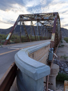
Rustic Gillespie Bridge spanning the Gila River with a mountain in the background
Old US 80 Bridge at Gila River – The historic Gillespie Bridge at Gila River, part of Old US 80, features a rusted iron truss structure and spans over the water with a volcanic rock mountain in the background.

I hope you enjoyed this week’s photo and reading about the Arlington Cattle Company and the old farm equipment that still represents Arizona’s ranching history. Don’t forget to check out the larger version of Arlington’s Abandoned Feed Mill Cattle on our website by clicking here. Join us next week for more fascinating stories and photos of farming equipment, from the old to the new. And who knows, maybe we’ll even find something borrowed and blue. Thanks for reading!

Till next time
jw

Bisbee’s Pythian Castle: A Clock Tower of History Bisbee, Arizona

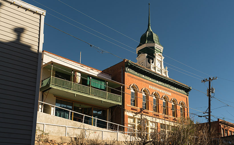
Bisbee's Pythian Castle: A Clock Tower of History - The green and white clock tower on the red-brick building pierces the cold blue winter sky.
Bisbee’s Pythian Castle: A Clock Tower of History – The red-brick building’s green and white clock tower pierces the cold blue winter sky.

During our December visit to Bisbee, Queen Anne and I was once again captivated by the town’s beauty and rich history. We finished the morning enjoying lunch at the historic Copper Queen Hotel before embarking on a walking tour of the city to capture new angles and perspectives with my camera. However, as we made our way up the town’s hilly streets, we were reminded that walking in Bisbee can feel more like hiking, and I must admit, as someone who dislikes exercise, I was less than thrilled.

Bisbee’s layout is like a wicked witch flashing you a peace sign with her crooked fingers. Her left finger is Tombstone Canyon, with galleries, shops, and cafes. The right finger represents Brewery Gulch, which holds several boutique hotels, restaurants, and a most attractive building—the Pythian Castle. This grand and ornate structure always winds up at the other end of my lens each time we’re there.

The Pythian Castle was built in 1904 as a meeting hall for the Knights of Pythias, a fraternal organization popular in the late 19th and early 20th centuries. The Knights of Pythias were known for their philanthropy and community service, and their membership included many prominent business people and politicians. The castle’s grandeur was a testament to their wealth and influence, and it quickly became one of Bisbee’s most iconic landmarks. Over the years, the Pythians gradually faded into obscurity, and the castle changed hands several times. Today, it is a popular venue for weddings, events, and ghost tours, but its history and architectural beauty inspire visitors and locals alike.

When I stand before a historic old building like the Pythian Castle, my mind floods with ideas of what I’d do with it if I had the wealth, time, and my youth back. At first, I saw it as a restaurant worthy of a James Beard award. The castle’s grandeur and history would make it a perfect establishment, offering diners exceptional food and an unforgettable experience. But why mess with a landmark the town is already proud of when there’s a better option next door?

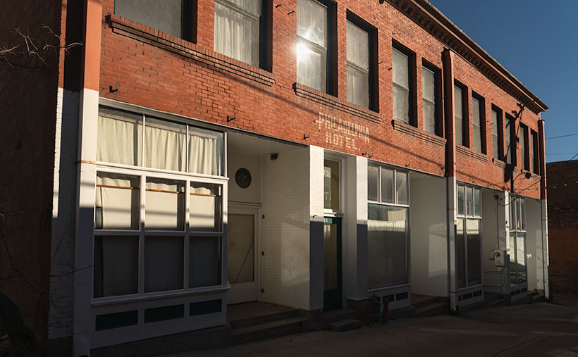
Nostalgia on Ok Street: The Philadelphia Hotel in Winter Light - I imagine that this forgotten hotel cries out at night, "Save me. Please somebody, come and save me."
Nostalgia on Ok Street: The Philadelphia Hotel in Winter Light – I imagine this forgotten hotel cries out at night, “Save me. Please, somebody, come and save me.”

Just a few steps away from the Pythian Castle is the Philadelphia Hotel, a historic building that has sat empty for years. Although there were plans for its renovation in the past, nothing ever came of them, and the hotel continues to await its chance to shine. Imagine the facade transformed with yellow-striped awnings like a grand Parisian bistro beckoning visitors to come in and dine, and the faded sign replaced with new copper letters. Inside, the hotel could be renovated into a destination restaurant, complete with tables covered in white tablecloths and serving up gourmet cuisine—I’d call it W.C. Fields. Our café only needs half of the building’s first floor, so that would leave enough room for another complementary business. Which would you choose: a bakery and gourmet deli, a Patagonia-style clothing store, or a luxury day spa where guests could indulge in some well-deserved pampering?

But the real gem of the Philadelphia Hotel lies in its 38 hotel rooms. With some TLC, a lot of elbow grease, and modernization, these rooms could be brought into the 21st century. The conservative route would be to restore each room with period furniture and modern plumbing. But why not go hog wild by halving the room count, doubling each room’s size, and wind up with 20 suites? Either way, the hotel would become a sought-after destination for travelers from all over the world. And with Bisbee’s growing popularity as a tourist destination, the Philadelphia Hotel could become the next big thing, drawing visitors in with its historic charm and modern amenities. The Philadelphia would rival The Copper Queen.

In my photograph of the Pythian Castle, I wanted to capture its grandeur and sense of mystery and intrigue. The late afternoon winter light added contrast to the scene, highlighting the details of the clock tower and spire. I chose a low angle to emphasize the castle’s height and dominance over the surrounding buildings, while the receding perspective of the street adds depth and dimension to the composition.

I hope you’ve enjoyed seeing this week’s images from Bisbee and that you found my pipe dreams fun. Click here for a larger version of the Pythian Castle photo on its webpage. Join us next week as we delve into Bisbee’s thriving art scene. We can’t wait to share more of Bisbee’s charm with you!

Till next time
jw

BTW:

Our friends, the Poteets, are touring southern Arizona and meeting with their adoring fans. Before they left, Fred swore on a stack of Bibles that their first stop would be Picacho Peak to capture the wildflowers growing on its slopes. When they return and have their slides developed, perhaps Fred will consent to share one of his finest.

Lowell Theater Lowell, Arizona

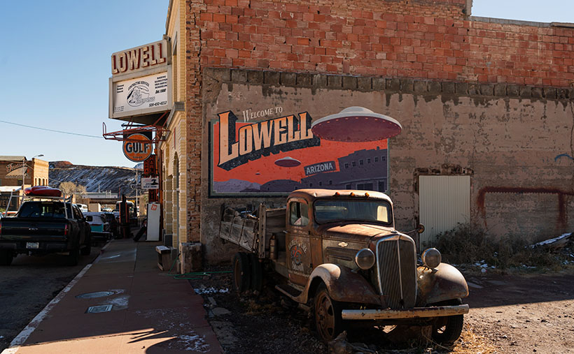
Lowell Theater - A Chevy flatbed truck parked at the Lowell Theater in southern Arizona.
Lowell Theater – A Chevy flatbed truck is parked outside the Lowell Theater in southern Arizona.

It was already well past lunch as we drove up Highway 80. Queen Anne’s all too familiar whining had begun, “I only had one meal today.” We were heading to Bisbee’s Copper Queen Hotel, where we could satiate our hunger. As we approached the Lavender Pit, I noticed an old Shell gas station in my peripheral vision. When I looked in the mirror, I saw that—not only was it real, but an old car was parked outside. That was enough catnip for me to slow the Buick and make a U-turn across four lanes of traffic. Lunch could wait.

When I turned onto Erie Street, I was surprised to see an entire block of old buildings with vehicles of the same period parked out front. Was I on a movie set, or had I died and gone to some photographer’s idea of heaven? I decided it had to be the former because I still heard Anne’s food grumbling in my ear. I was further confused by a wall sign saying, “Welcome to Lowell, Arizona.” I turned to Anne and announced, “We’re not in Bisbee anymore.”

Lowell is to Bisbee as Tempe is to Phoenix—a cling-on. Bisbee and Lowell were founded in the late 1800s as mining claims—Bisbee in the 1870s and Lowell in 1899. As the mines grew, they needed men to work them. Like every other mining town, the population lived first in tents, shacks, and finally, proper homes. Unlike the Tombstone mine, the ore at the Copper Queen Mine and Lowell Mine was so abundant that it supported the towns for over fifty years. That’s why these southern Arizona towns have masonry buildings instead of the rickety shanties of most ghost towns. Bisbee reminds me of the coal-mine towns in Pennsylvania or West Virginia.

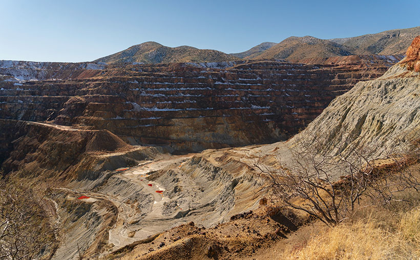
As time passed, the Copper Queen (and Phelps Dodge) took over the operation of the Lowell Company. Underground mines are inherently dangerous, and there was so much copper ore still buried there that during the World Wars, it became economically feasible to build giant machines to scrape away mountains and dig big pits to extract the copper. Bisbee’s renowned scab in the ground is called the Lavender Pit—named for Harrison Horton Lavender (the mine superintendent). As the abyss grew, it took parts of Lowell with it. All that remains of Lowell today is Erie Street which runs from the traffic circle in the south and the pit’s edge on the north side.

Lavender Pit - The famous Lavender Pit mine where tons of copper ore was dug from the ground. The pit is so vast I couldn't fit it all in the frame, even with my wide angle lens.
Lavender Pit – The famous Lavender Pit mine where Phelps-Dodge dug tons of copper ore from the ground. The pit is so vast I couldn’t fit it all in the frame, even with my wide-angle lens.

A group of volunteers banded together and formed the Lowell Americana Project. They worked hard to restore and enhance the quarter-mile street and transform it into an open-air museum. Their hard work got them international attention for their cultural preservation. They have turned Erie street into one of the most photographed streets in the West. Like me, you’ve probably seen some of those pictures in magazines and films without knowing the location.

We’ll explore Lowell’s Erie Street in February, hopefully, to delight my car friends. I consider this week’s photo the foundation shot. It was taken at the north-end parking lot where I left Anne to starve while I skipped up and down the street taking pictures. In this shot, I wanted to show the theater marquee, the Gulf, and the Lowell welcome sign. As an additional no-extra-cost bonus, the town thru in a Chevrolet flatbed truck. I don’t know what year it is, so perhaps one of you gearheads can tell us. I also have no idea about the flying saucers. I didn’t find a reference to any abductions in the area, although more aliens visit Arizona than any other place. They like the weather here—especially at Bisbee’s mile-high altitude. Maybe the spaceships are a warning that you’re about to enter The Twilight Zone.

You can see a larger version of Lowell Theater on its Webpage by clicking here. We’ll begin our walk down Erie Street next week to see what we can find. Be sure to come back then.

Till next time
jw

BTW:

No Queen Annes were harmed in the making of this article. She finally got her lunch and a glass of wine before she fell asleep as we drove back to the motel.

Crystal Palace The Town Too Tough to Die

Crystal Palace - When we travel to Tombstone, we make a point of stopping in the Crystal Palace and admire its back bar.
Crystal Palace – When we travel to Tombstone, we make a point of stopping in the Crystal Palace to admire its back bar.

How adventurous are you? Do you try new things or stick with the tried and true when you return to a location? I’d say that Queen Anne and I are 25/75 split. We always seem to return to the joints we’ve enjoyed but try to see what else is out there. I’m unsure if that’s adventurous or what other people usually do.

That holds for Tombstone as well. It may not be a surprise that when we get to town, one of our first stops is a bar—not just any bar, but we specifically make a beeline to the Crystal Palace. We don’t go there because the beer is cold or the wine is vintage; let’s face it, beer is beer, and bar wine is—ugh. When we are belly-up to the bar, the alcohol is only a vessel for a toast to a great piece of furniture—the Crystal Palace back bar.

The Palace is on the south end of town on Allen Street. During winter, they keep the front doors closed, but you can bust your way through a pair of a traditional cowboy swinging doors during summer. As you look around the cavernous room, you’ll see a bigger-than-life roulette wheel hung as wall art. The ceilings are two stories high and covered in stamped tin tiles. There’s a stage along the back wall where rows of cancan girls danced. On the room’s left is a massive mahogany back bar dwarfing the bartenders. The room smells of stale beer, French fries, and hamburgers smeared on a leather saddle.

The cabinet that is the source of our admiration reaches about three-quarters of the way to the ceiling. It has three arches supported by Corinthian columns with mirror inserts. I wonder how often those mirrors were targets of bullets or flying cowboys. It looks like one piece, but I’ll bet there’s a seam hidden beneath the center trim and festoon. On each of its flanks are matching liquor hutches. If you don’t have time to drive to Tombstone, you can see its twin sister in one of Prescott’s Whiskey Row bars (I don’t recall exactly which bar it was because I spent too much of my life doing research for this article).

We don’t grow mahogany in Arizona or any other hardwood that would be nice enough for cabinets like this. This one was ordered from furniture makers in New England and then shipped around South America’s treacherous Cape Horn (no Virginia, the canal wasn’t yet built). Once the sailboat reached the Sea of Cortez, the bar was unloaded and carried overland by wagon.

If you’re hungry, you can order food. It’s not the worst place in town, but it’s still bar food. They prepare onion rings in-house, notably better than those awful versions at Jack’s or The King. If the tour busses are in town, the place will be packed, and the crowd can overwhelm the staff. Then you’ll have to be patient with your food and bill. But it’s not any better at the other restaurants.

There is one more thing about the Crystal Palace that I should warn you about—especially in spring. For some reason, enough couples are getting hitched in Tombstone; the town provides them with sideshows. On one of our visits, we noticed a table full of guys having a bachelor’s party. They had a great time drinking beer and being loud when suddenly an attractive woman dressed in a bright red dance costume burst through the swinging doors. She was followed by three men with handlebar mustaches wearing long black dusters and deputy badges. The young woman walked over to the groom-to-be and pointed her finger at him. She shouted for the entire world to hear, “That’s him! That’s the slime ball. Last night he promised to love me forever, and today he’s running off with another woman.”

Then the deputies grabbed the scoundrel under his arms and dragged him through the side door to the hanging tree out back. The crowd emptied the bar and filled the streets. Once there, the posse strung him up but stopped until someone fetched the bride.

Once she arrived (accompanied by her entourage), the lawmen presented their case. After hearing what they had to say, she promised that after their wedding, she’d set him straight, and he would never do it again. The sheriff polled the crowd, “Do you believe her?”

Most of the mob said yes, so he removed the noose, and we all went back into the bar and ordered another beer—on the groom.

I called this week’s picture Crystal Palace, and it’s of the cabinets described in my story. I was happy that my shot was sharp in such a dark room without using a flash or a tripod. I lightened the wood in post-production to show off its luster and grain. To get a clean shot, I had to wait for the bartenders to go to the kitchen window. Sometimes it pays to be patient.

You can see a larger version of Crystal Palace on its Webpage by clicking here. I hope you’ll join us next week when we come back with another Tombstone story.

Till next time
jw

BTW:

Are you ready for flowers? With the frequent rain this winter, we will have a bumper crop of wildflowers. Now is the time for you to come up with some strategery on where to go to photograph them.

Gunfighters The Town Too Tough To Die

Gunfighters - Actors dressed in Earp costumes try to stay warm on Allen Street while they coax visitors to come see the 3:00 pm show.
Gunfighters – Actors dressed in Earp costumes try to stay warm on Allen Street while coaxing visitors to see the 3:00 pm show.

Ghost towns in Arizona are a dime a dozen. There are enough of them to fill a book. I know because I currently have five of them sitting on my shelves. The morphing of a city into a ghost town follows a familiar pattern. It starts with some loony prospector finding a valuable mineral—gold, silver, copper, diamonds, or another precious stone. News of the bonanza spreads quickly and lures a gaggle of opportunistic people. Half of them want to get rich by picking nuggets from the ground, and the rest want to pick them from someone’s pockets.

A new town springs from the ground like a children’s pop-up book. More people settled in the town and either got jobs at the mine or open shops that every mining community needed, like bars, gambling halls, and whore houses. Eventually—in a year, a decade, or a century—the gold (or whatever) pans out. The excitement of living in a mining town slowly dies, and its residents move on to the next boom town. Mother Nature reclaims the land without caretakers; all that remains is a pile of rotting wood, some foundations, and the eerie spirit of ghosts.

Of course, there are exceptions to my rule. In a handful of cases, when the mine goes bust, its residents look around and say to themselves, “This is a great place to live.” They find other sources of income. I call these places amusement communities. Examples that come to mind include Oatman, Jerome, Bisbee, Bagdad, Clifton, and Tombstone.

Of those locations, Tombstone is the odd duck. There are no gaping open pits to gawk at, historic hotels, or James Beard-worthy restaurants. I suspect that most of its visitors don’t even know about the silver mine. That’s because the silver vein wasn’t gigantic, and that’s how it got the name Goodenough Silver Mine. A gunfight between the Earps and the Clantons secured Tombstone’s historical spot. If it weren’t for that singular gang fight, Tombstone—’The town too tough to die’—would be a pile of splinters by now.

Don’t get me wrong; there is a list of exciting things to see in Tombstone. It was the Cochise County seat for a while, so there’s the old courthouse (with its gallows patio), the Crystal Palace back bar, the world’s largest dead rose bush, and the Birdcage theater should be on everyone’s checklist. Of course, if you have the time and money, you should see the show at the OK Coral, but realize that the actual gunfight was on Highway 80—behind the Coral.

I took this week’s photo on a cold, windy December afternoon. We had checked into our motel and started into town before the light faded. Standing in the middle of Allen Street (dirt, then paved until the street department poured dirt over it again—for authenticity) were four gunfighters dressed in black wearing badges. They tried to stay warm while they hawked visitors to the 3:00 pm show. I don’t know how successful they were because the streets were empty as people sheltered inside the bars. I titled this shot Gunfighters.

You can see a larger version of Gunfighters on its Webpage by clicking here. I hope you’ll join Queen Anne and me throughout January as we show some of the exciting Tombstone scenes we found.

Till next time
jw

BTW:

Queen Anne and I are working on our calendar for the year. We’re putting together a list of places we’d like to visit and this year’s book topics. If you have any requests, let us know in the comments section.

Ancient Door Picture of the Week

Ancient Door - A mysterious door between Lomaki rooms beckons you to see what's on the other side.
Ancient Door – A mysterious door between Lomaki rooms beckons you to see what’s on the other side.

When I photograph a place like Lomaki (the Hopi word meaning Beautiful House), I try to walk its perimeter, looking at how the light falls on it. Then I look at details that help fill in its story. As I move around, I’ll stop and take shots of things that intrigue me. My photos are more intuitive than systematic. I look for contrasts and shadow patterns that place the subject in a specific moment.

I was doing that when I entered the Lomaki ruin and came across the door in this week’s picture. I saw the door and thought, “This looks interesting.” I framed the shot and snapped the shutter. Typically, an image with a busy pattern in a uniform light doesn’t work because it looks like a Where’s-Waldo puzzle. However, the dagger of light on the room floor commands your eye to go through the opening. It’s a walk-towards-the-light moment.

As a younger man, I was six-foot tall, but gravity has taken its toll, and now my diminished stature is only 5 foot 11½ inches. Even in my current dwarf state, I had to do a full Asian bow to fit through the doorway. That means that the Pueblo people that built this structure were short. Otherwise, they would constantly bang their heads on the lentil when they came home Saturday nights drunk from the bar. Believe me, that gets old fast.

As I walked through the complex, I got to another room with a low window. Through it, I saw a creature with five legs. It gave me a fright. Was it a centaur with an extra appendage or a giant arachnid with three legs missing? On closer inspection, I saw three legs were carbon fiber, and the other pair wore shorts. The creature turned out to be a fellow photographer. She was a coed from ASU working on a YouTube video about Wupatki.

It’s funny how photographers behave when they bump into one another out in the field. After seeing another camera, they let down any guards. They stop being solitary wanderers and suddenly become highly social as they compare notes. “Did you see this?” You should go there.” In the age of digital photography, it’s gotten worse because now they can compare their shots on the back of their cameras and go into full chimpanzee mode, “Look at this one—ooh ooh ooh ah.”

After our pleasantry exchanges, we parted ways, and she returned to the parking lot. Of course, I didn’t ask for her name or YouTube channel. Queen Anne would kill me on the spot if she knew I talked to a college-aged woman in the field without her chaperoning. After I finished shooting, I hiked back to the parking lot, where Her Majesty was waiting in the car. If I was lucky, her nose was buried in her Kindle reader, and she didn’t notice anything. Before I could say a thing, she blurted out, “I asked that girl if I had to go rescue you.”

“What did she say?”

“She said you were happily wandering around snapping pictures, and you’d be there until you ran out of film.”

It was only then that I realized I was a bit hot, so I started the Jeep and guzzled some water in the cool air conditioning before driving back to Flagstaff. So far, there are no new YouTube Wupatki videos, but I’ll keep looking while I dream of mermaids.

You can see a larger version of Ancient Door on its Webpage by clicking here. Next week, I’ll show my last shot from Lomaki, so be sure to come back and see what we find.

Till next time
Jw

BTW:

It’s Thanksgiving week, so Queen Anne and I wish you a happy and safe turkey day.

Lomaki Picuter of the Week

Lomaki - The crooked walls look as if the fierce Northern Arizona winds will blow them over.
Lomaki – The crooked walls look like the fierce Northern Arizona winds will blow them over.

In the half-century that I’ve called Arizona home, I can’t count the times that I’ve traveled thru Flagstaff and then north on Highway U.S. 89. I travel that route to get to the Grand Canyon, Lee’s Ferry, Lake Powell, Monument Valley, Utah, or Colorado. My best guess would be once a year on average. Sometimes I even stop to take pictures along the way.

With that many trips, you’d think I’d pay no mind to the scenery, but that’s not true. There’s always something new. There’s one location that makes my jaw drop, no matter how many times I see it. I’m talking about the view at Sunset Crater Pass I wrote about last month. It’s an in-your-face example of something I learned in a college geography course: mountains affect climate.

The climate on the south side of the San Francisco Peaks is the polar opposite of that on the north. As you travel to Flagstaff from Phoenix, you climb into the pines, and the temperature can drop as much as 30° along the way. As fronts move north from the Gulf in the summer or west from the coast in winter, the mountains wring moisture from the air as it climbs the slopes. After passing over the mountains, the air is dry and picks up pressure on the way down. Dry air heats faster than humid air. The phenomenon creates a rain shadow on the mountain’s leeward side. The next time you travel north of Flagstaff, stop your car at the pass and take a look back—trees. Then turn to the north again—trees kept away.

Now that you know how mountains work, it’s easy to understand why the early Pueblo Tribes living at Wupatki lived in rock dwellings instead of log cabins. Amazingly, the Indians still used timbers to span the walls and hold up a roof. That means they had to drag lumber off the mountains by hand. They built their structures before the Spanish arrived, so they didn’t have horses.

This week we’re looking at one of the bigger pueblos in the National Monument—Lomaki. That’s a Hopi word that translates into English as “Beautiful House.” Anthropologists have partially restored its two-story walls. As you walk through the ruins, you begin to appreciate the ancient people’s masonry skills and tenacity. They must have had to rent scaffolding for walls that size at A-Z Rentals in town. It was either that or standing on one another’s shoulders. You’d do the same thing.

In this week’s picture, titled Lomaki, you get a good idea of the wall height. The windows are at eye level. A peculiar thing you notice in this shot is the walls are leaning. I’m not sure if the scientist put that feature in on purpose or if they weren’t as skilled as the original Pueblo builders. As a photographer, I have a thing about lines that aren’t level or square. Oceans don’t run downhill, so I wince whenever I see a seascape with a crooked horizon. On my first visit to Lomaki decades ago, its tilted walls jumped out at me. They look like a good wind will blow them over—and this area of Arizona is exceptionally windy. However, on this year’s visit, the walls were still standing and didn’t seem any worse, so maybe they’ll remain long after I’ve gone.

You can see a larger version of Lomaki on its Webpage by clicking here. Next week, we’ll walk around Lomaki and see its details. Come back then and see what we find.

Till next time
Jw

BTW:

The calendar cut-off day is Tuesday, so if you are interested, place your order.

%d bloggers like this: