89 Sunrise Picture of the Week

There are two types of drivers on the road. The first type is people trying to get somewhere, while the second group is people who are out for a ride. You’re not always stuck in one group or another. Sometimes you have an appointment to make; while on other occasions, you have all the time in the world. My dad was part of the gotta-get-there group. Once he got in the car, he didn’t stop for anything unless it was gas. Although he was our family’s driver, I don’t think he liked it much.

I’m part of the second group. On a day like today, sunny and temperatures in the mid-seventies, I relish driving an excellent machine down back roads with the windows down so the wind can blow where my hair used to be. These are the times when I feel most alive and free. Nothing beats driving an empty winding road with a hot blond beside you in the passenger seat—even if it’s just my blow-up doll—er, sorry. I got carried away there. I see a time soon when we’ll have autonomous vehicles, and that’s fine as long as I’m not in one.

That brings me to one of our community’s best features—the road leaving town. Up until the Second World War, our trail carried most of the traffic between Phoenix, Prescott, and Flagstaff. At that time it was part of the U.S. highway system, and its designation was US89. After the Highway Department opened the last section of Interstate 17, the Feds depreciated our road, and now it’s officially Arizona State Route 89. During its heyday, US89 stretched between the Mexican Border at Nogales and Canada at Glacier National Park, but today it stops at the US66 junction in Flagstaff.

89 Sunrise
89 Sunrise – The road heading north out-of-town starts by climbing over the Weaver Range at Yarnell Hill.

Now that most of the traffic is on the freeway, SR89 has become a scenic back road that drivers love with low traffic, almost no trucks, plenty of curves, and a variety of scenery. I can prove it. On any weekend you can sit in your lawn chair at our park’s driveway and watch clusters of geezers on Harleys, boy-racers on rice rockets, and waves of sports car clubs headed north on Saturdays and south on Sundays. On weekdays, the proving ground boys’ wiz by driving disguised test cars and trucks. You know they’re having fun because you can see dilated eyes behind their Ray Bans and they have big grins on their faces.

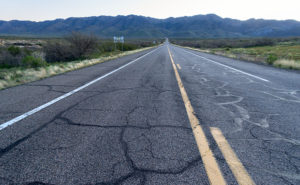
When I thought about this week’s featured image, I wanted the road front and center, and the spot that I chose is where SR89 heads towards the Weavers as if they’re going to crash. They don’t however, because, at the last moment, the road turns right and starts up Yarnell Hill. If you’re traveling in a group, that’s where the race starts—well, actually I don’t need others because I raced in autocrosses—ask Queen Anne.

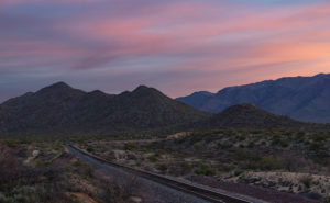
For this shot that I named 89 Sunrise, I wanted to have my tripod in the middle of the street, so I needed an empty road. That’s why I got there and set up before this morning’s sunrise. The highway is the subject of my image, but the Weaver’s aren’t bad either. In this shot, there’s a lot of green, but in a few weeks, it will turn golden brown.

You can see a larger version of 89 Sunrise on its Web Page by clicking here. I hope you enjoy viewing this week’s post and come back next week when we’ll start a month of featured images from another Arizona place.

Until next time — jw

North Bound
North Bound – An early morning freight train at the Congress Crossing.

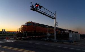
PS—As I was finishing up this morning’s shot, I could hear a freight train pulling the Wickenburg grade, some four miles away. So I quickly packed up and rushed down to the crossing and got this image. It’s not the shot that I described last week, but at least it’s a train.

Starring Queen Anne YouTube Video Announcement

As you all know by now, Queen Anne and I spent August last year so that I could photograph along Utah’s State Route 12 (wrote a book about it—wan’ a see it—here goes). What you didn’t know is that one morning we drive to Torrey for lunch, and we filmed a time-lapse video with a GoPro stuck to Archie’s roof. It took a while, but I finally assembled all the clips into a 14-minute video that I posted on YouTube this morning.

Thor's Hammer And Sunset Point
Thor’s Hammer And Sunset Point – Bryce Canyon is the reason most visitors ever drive SR 12, but the video shows what to see before and after Bryce Canyon.

The video shows all of SR12’s 122 miles, and I spliced in spots along the route that are waiting for you to see and photograph. Queen Anne stars in her YouTube debut that will most likely break the Internet. Finally let me say that although it looks like a mad man was driving, I can assure you that the cruise control was set to the speed limit—of course, that may not absolve me from being a crazy person.

You can see Utah’s State Route 12 on YouTube by clicking here. I hope you enjoy watching it and please share your comments or at least give it a thumb up or thumb down.

Until next time — jw

Sunrise on Track Picture of the Week

There are only a half-dozen places Queen Anne, and I frequent in our home town of Congress. There’s Nichol’s West—our favorite local restaurant, the Post Office, the clinic, the Kwikie Mart, and the Dollar Store. Oh, I forgot the dump. For anything else, we have to drive into town or—shudder—the big city. Half of those in-town destinations are on the west side of the railroad crossing, which never has a train—most of the time.

I wrote in a newsletter about our train when we first moved here. This section of track is called the Pea Vine Grade that follows Highway 60 out of Sun City till Wickenburg then continues north to Prescott and Ash Fork. The name is descriptive of the twists along the route.

The tracks aren’t busy like the southern route in Yuma, or the north through Flagstaff. This route isn’t bustling and only has four to six passing trains each day. They’re not on any schedule that I can discern and you don’t hear them go by as much as you feel their bass vibrations, especially the ones coming up the grade. The five engines work hard dragging loaded freight cars up the hill, while the ones headed south sound like a wooden roll-a-coaster as they effortlessly roll downhill. Their horns only blare in Wickenburg and the Congress crossings. That’s too far away to hear from the house unless we’re sitting on the back porch and there’s a north breeze coming off the mountains, but even that’s so faint that it’s like a scene from a Steinbeck novel.

Sunrise on Track
Sunrise on Track – Dawn breaks with a red sky over the railroad tracks heading north from Congress Junction.

This week’s featured image turned out completely different from how I originally visualized it. I wanted to capture this shot with a train in it. The tracks come into Congress Junction from Hillside through the valley between the Date Creek Range and the Weaver Mountains. On most mornings, there’s an early southbound train. We’ve seen it while we’re out for our morning walks. To further set the scene, the Date Creek Range foothills at the crossing are prettiest at sunrise. The rest of the day, they’re flat and dull. So that’s what I had in my mind when I drove there in the dark.

I previously scouted out a lovely spot overlooking the tracks, and I set up my camera and waited for the characters to arrive. As the eastern sky got brighter, the clouds overhead turned red, and I thought, “Ooo shiny.” I fired off a couple of frames. As I waited, the fast-moving clouds moved east and began to block the sunrise removing any drama from my scene. Besides, no trains showed up. Disappointed, I packed up and drove around town looking for other subjects to shoot.

When I got home and reviewed my images, this was the shot that impressed me the most. Even without a train, the tracks are a leading line that moves your eye to the foothills.  The light bouncing from the clouds tints the scene pink, and that light softly brings out the mountain’s cone shape. There is a feeling of tranquility in this shot. It’s a moment of quiet and calm.

You can see a larger version of Sunrise on Track on its Web Page by clicking here. I hope you enjoy viewing this week’s post and next week; we’ll show another featured image from Congress.

Until next time — jw

Rock Frog Picture of the Week

Our adopted town of Congress is a small retirement community, although it wasn’t always that way. Like most of the old mine towns around here, plenty of people lived here as long as they could yank gold out of the dirt; at times, there were even more people here than living in the little farming village called Phoenix. After all the money was gone, there wasn’t any reason to hang around here. The soil’s too rocky to farm, and there’s little to see here.

However, We have one attraction that puts us on the map, and I like to think it came from boredom. I imagined one summer’s day in 1928, and young Sarah Perkins–a homesteader’s wife—was in the shade of their front porch seeking relief from the oppressive heat. As she rocked in her chair, sweat soaked her gingham dress. The glass of refreshing lemonade that she held to her brow felt good as she stared at the pile of rocks across the highway near the railroad tracks. She turned to her husband sitting in the chair beside her and said, “Lester,” (I couldn’t find his name, so I picked one from my head) “The next time you’re in town, I want you to pick me up some green paint.”

Lester was a wise man who knew better than to ask, “What for?” A couple of weeks later, when he returned from town in the Model A pickup, two cans of Sarah’s paint and three large brushes were buried within the other provisions. The very next day, in the cool of the morning, she led her sons across the road to the pile of rocks, and they began to paint.

Frog Rock
Frog Rock – The pile of boulders painted to look like a frog has been a Congress landmark since 1928.

If that’s not how it happened, it’s how it should have been when Sarah created our green rock frog. I agree, it’s tacky kitsch, but it’s our giant ball of twine, our world’s largest ketchup bottle, or our Lucy the Elephant. It’s a point of pride in our town, and when the paint fades, a self-appointed committee repaints it. I think that the Highway Department has given up on removing it, because, like the elephant on Yarnell Hill, it always returns. This last time, they added spots to the frog’s back.

I wanted to show more than just a frog when I shot the frog. I wanted to show how the 50-ton boulder looked unpainted, so I included some granite boulders in the foreground in a supporting role. I call this week’s image Rock Frog partly because I had a B-52 song stuck in my ear.

You can see a larger version of Rock Frog on its Web Page by clicking here. I hope you enjoy viewing this week’s post and come back next week when we’ll show another featured image from Congress.

Until next time — jw

Mobil Antlers Picture of the Week

A long time before we moved here, I remember driving through our little hamlet and noticing the old buildings in town. Queen Anne and I were traveling to visit my folks in Kingman, and after leaving Wickenburg, traffic stopped. Thinking it must be a result of an accident, I said to Anne, “We can detour around it by going to Congress.” It was ten miles out-of-the-way, but at least we’d be moving. It was when we reached the village that I saw the structures and said to her, “That’s so cool. I don’t remember this being a ghost town. I’ll have to come back and photograph it, someday.” (As an aside, my detour didn’t work because the accident was further north on US 93. We finally drove over to the river and took US 95, which put us several hours behind.)

There’s a reason why I didn’t remember those old buildings even though I had gone that way several times before. They weren’t there. After moving to Congress, that someday that I had set aside to photograph Congress’s historic district finally came. When I did, it disappointed me to learn that they’re a fake, like a back-lot movie set. The buildings are empty shells apparently used to display someone’s antique sign collection, but I don’t know why. It’s like someone threw up some structures as a tourist attraction and then quit before finishing.

The area of town at the  AZ 89 and AZ 71 junction isn’t the historic part of Congress. It used to be called Congress Junction or Congress Depot. The historical part of town was up Ghost Town Road near the mine. In this Wikipedia article, there’s a 1914 photograph that shows how it was. When the mine closed in the 1930s, the town moved to today’s location—lock, stock, and barrel. All of the buildings in the photo are gone. The land was scraped clean, including the mine structures. The only thing remaining is the old cemetery and a shed for Stephan—the mine’s caretaker.

Wouldn’t it be nice if someone bought and moved these buildings along the railroad tracks from old town? I don’t know, because there’s nothing to explain their existence. The only remaining business there is someone selling landscape rocks. Maybe you know the story and can share it with us, or perhaps, when I get a ’round-to-it,’ I’ll investigate and post an update.

Mobil Antlers
Mobil Antlers – An antique Mobil Oil flying horse is displayed over a pair of antlers at Congress’s fake garage.

I’ve pretty much ignored this part of town for the past three years, but since we’re featuring Congress during March, I wanted to show you what always catches my eye as I drive by them. It’s the Mobil Oil red flying horse sign. I’d like to have something like it to hang on the gable over my garage door—perhaps a Ferrari, Porsche, or one from Sunoco. To be accurate, however, my sign would be for beat-up Chevy station wagons.

In this week’s featured picture that I call Mobil Antlers, a set of antlers upstage the flying horse, so I concocted a fantastic story about it. It represents a tale about a red horse that soars high in the sky. He spots his prey in the meadow below—a handsome buck. The horse swoops in for the kill, and there’s a mighty struggle with the deer attempting to gore the soft underbelly of its attacker. Red-horse prevails and devours Bambi except for the antlers because they’re indigestible. Then I thought, nah—I’m not going to say that—it’s just too bizarre, and people will think I’m weird.

You can see a larger version of Mobil Antlers on its Web Page by clicking here. I hope you enjoy viewing this week’s image and come back next week when we’ll talk more about Congress.

Until next time — jw

Weaver Snow Picture of the Week

The weather here in Congress has been variable. I remember writing last year about the lack of rain, and we haven’t had that this year. It seemed like a new front moved through each week with more precipitation. The winter’s highlight, however, was last week’s snowstorm. There was enough of the white stuff covering our yard that we could measure it with a ruler (inch and a half). We’ve woken to frost and snow before, but this time it came down in the afternoon with temperatures well above freezing. Snow covered the surrounding mountains for days, and it looked more like Colorado than the desert.

During this time, I was trying to find a place for this month’s images, and I decided to stay at home this month and feature Congress. It’s been a while since we’ve done that, and besides, I need to cut down on my gas bill anyway.

Weaver Snow
Weaver Snow – Traces of snow remain on Weaver Peak following a winter storm.

This week’s featured image helped me decide to stay local. I wanted to show you how pretty the snow was on Weaver Peak, so for days, I waited for the sky to settle so I could shoot the scene without slogging through mud. Three days passed before those conditions were met and I was able to capture this image. I waited for the last rays of the sun, so that gives it that red glow. I call this image Weaver Snow, and I hope you enjoy it. For me, it shows one of the reasons that Queen Anne and I moved to the sticks.

You can see a larger version of Weaver Snow on its Web Page by clicking here. I hope you enjoy viewing this week’s post and next week; we’ll show another featured image from Congress.

Until next time — jw