Harquahala Sunset Picture of the Week

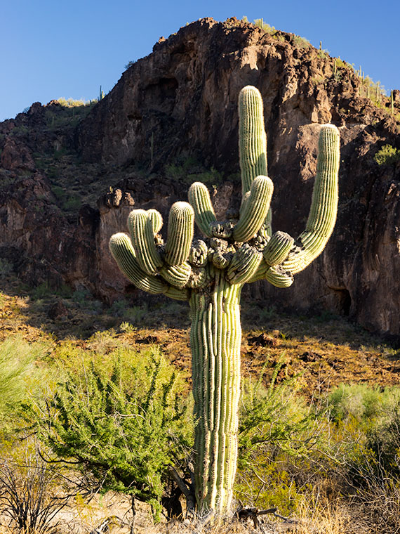
Oh my, it’s another Sunday already. It’s the last Sunday of our Harquahala trip, of the month, the year, and the decade. I should have thought of something profound to memorialize this moment. Alas, I’ve been too busy staring at all of these trees to notice a passing forest. I’ll try to do better ten years from now.

For this week’s episode, we’ve turned the corner, literally. Anne and I had been traveling southwest on the Eagle Eye Road, and to continue, we turned right on the Salome Highway, which runs northwest from Buckeye to Salome. At one time, the highway was a detour while they built Interstate 10. Now, both roads are free of traffic. As when we made stops along the way, I pulled off on the broad shoulders, but I didn’t need to. There was no traffic to block, so I could’ve parked in the middle of the road.

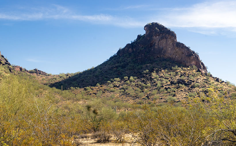
As we drove toward Salome (“Where she danced” Dick Wick Hall; one of Arizona’s famous humorist and former Salome resident), the day grew late. The long shadows on the mountain began to look like a minimalist graphic in the style of an Ivan Earl painting, or a Scotty Mitchell pastel. So, I searched for a spot where I could take a picture of the mountain behind a sea of creosote. I found such a place near a large ranch. So I got a chance to shoot this image with and without buildings in the distance. I preferred this version, and I called it Harquahala Sunset.

Harquahala Sunset - With the deep shadows and minimalist styling, this photo reminds me of the style of some artists that I admire.
Harquahala Sunset – With the deep shadows and minimalist styling, this photo reminds me of the style of some artists that I admire.

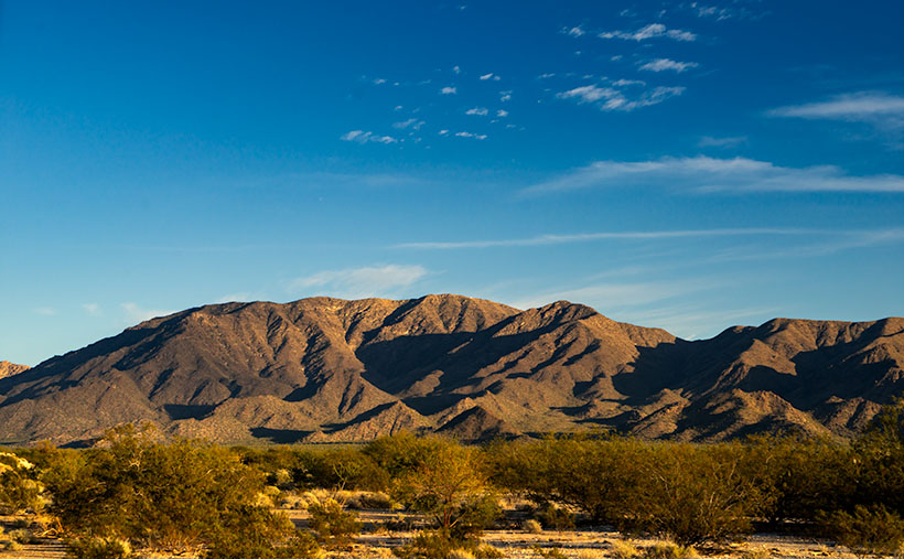
The part about “without buildings” is a lie. As I processed this picture, I combed through it, looking for dust spots—a regular part of my routine. That’s when I discovered the ruins of the 1930s solar observatory. At the top of the highest center peak is a white tower and utility building. They’re abandoned now, but a few miles behind us, there’s a ten-mile road that goes to the mountain’s top. It’s a challenge that is too much for Archie, but I’d like to take that trip someday.

You can see a larger version of Harquahala Sunset on its Web Page by clicking here. I hope you enjoy viewing it. Next week, we’ll be talking about a new back-road trip somewhere in Arizona.

Until next time — jw

What Happened to You Picture of the Week

Arizona has a reputation for being hot—deservedly so. Especially here in the Sonoran Desert. We frequently make the weather news for hosting the highest temperature of the day—a contest in which Gila Bend and Bullhead City are always locked in battle. For some people, any press is good press.

But as I explore the back roads of our state, I’ve come to the conclusion that the heat here had to be way worse many millennia ago. I came to this conclusion because you can’t walk more than ten steps before you step in a puddle of cooled lava—basalt (cooled quickly on the surface), andesite (mixed cooling), and granite (cooled slowly beneath the surface). Not all of this volcanic activity happened at the same time of, course. Millions of years separated eras of activity. What I’m saying is that, at times, Arizona’s ground heat far exceeded our summer temperatures. It’s probably a good thing that we’re living in this era.

The reason I’m hopped-up on geology this morning is because of the next stop that Queen Anne and I made on our one lap of Harquahala Mountain trip. Near where the Eagle Eye Road intersects with the Salome Highway, a series of volcanic hills line the south side of the road. After getting out and clambering all over them, I decided that they didn’t have star power. They’re interesting, but not that interesting. During my investigation, however, I found this poor little weird saguaro. It had eight new arms growing around it’s lopped off the top—sort of like last month’s headless version. As I got closer, I saw that the new arms were growing from other truncated arms—at least a dozen of them. It was—much like a cat eats grass to settle its stomach—like a T-Rex chomped off its top, so the saguaro put out new shoots. I remember thinking, “What the hell happened to you?” Was this caused by freezing, disease, or repeated lightning strikes? I don’t know, I’ve never seen a saguaro like this.

What Happened to You-a poor little saguaro has arms growing out of damaged arms. What caused this to happen?
What Happened to You -A poor little saguaro has arms growing out of damaged arms. What caused this to happen?

I decided to capture its portrait, and, as I framed it, the hills came in play. I lined up my shot so that the sunlit saguaro was centered on the dark rocks on the outcrop. I was so impressed with how clever I was, I also shot a dead tree and palo verde in the same way, but they didn’t come out as well. I titled this shot What Happened to You, and it’s this week’s featured image.

You can see a larger version of What Happened to You on its Web Page by clicking here. I hope you enjoy viewing it. Join us next week as we finish up our trip around the Harquahala Mountains.

Until next time — jw

BTW: Queen Anne and I wish you and your loved ones Bah Humbug—and similar salutations of the season.

Desert Broom and Windmill Picture of the Week

I’ve spent a lot of time in the desert recently. I’m less likely to run into snakes now that the weather is colder. But, there’s still a lot to be wary of when you’re out in the wild. There’s the cactus, especially the Jumping Cholla, the barbed wire, and all the illegal garbage scattered along the trail. One of the most frequent things I have to avoid is all of those cow pies. As I move, my eyes are on the ground; then, I stop to look up to get my bearings. There may not be a cow within miles, but their droppings are everywhere. I Googled it and found a state agricultural Website that said, “Grazing fields account for 73% of total land use in the state and 98% of its agricultural landholdings.” That’s a lot of free-range lands.

Desert Broom and Windmill-The picturesque windmills don't provide an efficient supply of water to cattle as water tables drop
Desert Broom and Windmill-The picturesque windmills don’t provide an efficient supply of water to cattle as water tables drop

You can tell ranching in Arizona is a big deal by the number of windmills and clumps of green trees you see as you drive down the highway. The green areas are usually associated with stock-tanks—the ranchers plow low dams on washes to retain the run-off, and the windmills pump groundwater into large metal tubs from which the herd gets a drink.

Not many of these windmills actually spin these days, regardless of how much the wind is blowing. Some of that is because the water table is dropping. There has been an ongoing drought here, and we’ve pumped enormous amounts of water out of the ground over the years. Instead of drilling the wells deeper, ranchers disable the windmills and truck water in to fill the tanks.

On our “One Lap of the Harquahala Mountains” tour that Queen Anne and I did last month, I was challenged with either shooting the mountain repeatedly, or finding interesting things that broke the monotonous sea of creosote, so when I saw this windmill off in the distance, I hiked in for a shot. When I got there, I liked the shiny metal fan against the sky, but I wasn’t impressed with its doughboy style galvanized tank. It looked as if thirsty bovine stampeded over it. Luckily there was some desert broom nearby that helped in a couple of ways. The green plants were in bloom—that’s as close as you get to fall color in the Sonoran Desert, and they camouflage the damaged tank.

I named this week’s featured image Desert Broom and Windmill. I like how the light was beginning to come in and how Harquahala Mountain shows in the background. I’m also partial to the high cirrus clouds, so I was pleased that they frame the windmill’s blades.

You can see a larger version of Desert Broom and Windmill on its Web Page by clicking here. I hope you enjoy viewing it. Join us next week as we continue along our trip around the Harquahala Mountains.

Until next time — jw

Saguaro at Harquahala Mountain Picture of the Week

I was researching today’s post, and I found some interesting statistics—at least they are for me—and on an online forum thread that made me smile. In case you hadn’t noticed, I like mountains. I like them big or small, a long chain of peaks or lonesome butte, snow-covered volcanoes or desert ranges. I like them because they’re not flat and they’re visually stimulating. You can gauge travel distances with them. I’d be a terrible mariner out on the sea without landmarks. When I travel through Kansas, I have to replace peaks with grain silos.

I want to learn more about what I see and photograph. I want to know the peak names, their heights, their make up, and how they formed. Most of my curiosity is satisfied with topographic maps, but the geology stuff is gobbledygook.  I wish there were an easy decoder book written for simpletons like me.

The Harquahala Mountains—the subject of this month’s images—are a substantial range, one of the highest in Arizona’s southwest quadrant. I can see its distinctive round shape from my back porch. I started tagging my films with the name Harquahala Studios because it’s fun to say: HARK—qua-hala. Last week I learned that the name in the Mohave language means “water, up high” presumably from the springs on its slopes—a handy fact to know if you live in the desert.

I Googled “Arizona Mountains” this morning and found it listed in the 5,000-6,000 foot elevation group. To find the exact answer that I wanted would have required more research, spreadsheets, and an effort that cut into my nap, so I gave up. But I saw another question in the list that piqued my curiosity. “Which state is most mountainous?” What’s your guess? Set aside Alaska because they don’t play fair. Is it Colorado, California, or Montana? In the discussion, some people were arguing that it’s West Virginia, which is in the Appalachians, and the highest peak is under 5,000 feet—hardly a mountain. They explained that the little state has the lowest percentage of flat-land, so it’s all mountains, therefore the most mountainous.

The answer wasn’t Colorado; California has 500 more named peaks, and Montana is two-thirds prairie that the locals call West Dakota. The response surprised me, but since I read it on the internet, it must be true. Being entirely comprised of the Great Basin Desert with north-south running ranges, Nevada has the most named peaks in the lower forty-eight. They’re not the highest, but there’s a gob of them.

Saguaro at Harquahala Mountains-A line of saguaro looking like telephone poles lead your eye to the massive mountain south of Aguila, Arizona.

This week’s featured image is called Saguaros at Harquahala Mountain, and I shot it south of Aguila, a few miles south of the Eagle Eye Peaks in last week’s post. What made me stop to take this image was the line of saguaros that looked like a row of telephone poles. They create what’s called a leading-line—a perspective tool that brings your eye into the massive mountain. The clouds and the small Palo Verde tree work to keep your attention in the picture’s center—if it works right, your eye moves in a clockwise circle.

You can see a larger version of Saguaro at Harquahala Mountain on its Web Page by clicking here. I hope you enjoy viewing it. Join us next week as we continue our lap around the Harquahala Mountains, and remind me to stay out of the flooded washes.

Until next time — jw

Apostrophe Butte Picture of the Week

I’m down to the last page on my calendar this morning. It’s already time to get a new one. Einstein may have been right about time being relative, but I think he got it backward. Instead of the clock slowing down as you travel faster, time speeds up as you age. Don’t you remember how a week dragged when you had a date on Saturday night? Now it seems like Queen Anne, and I make our weekly run to the garbage dump every other day. What upsets me is that there’s little time for my daily naps anymore.

With a new month comes a new road to explore. We’ve had an extended summer, and it has been a very dry fall, so I initially thought that her majesty and I could go into the mountains. But that all changed recently and we’ve had wave after wave of Pacific storms roll through. Being less daring than I was, I changed my mind and looked for a closer route. One that wouldn’t have snow or mud, or maybe wasn’t even dirt. I mean, we’ve all watched the local heroes on the evening news as rescuers drag them from flooded washes. I’ll only go so far for free-press.

So, I packed the camera, some snacks, and my wife for a lap around Harquahala Mountain using three roads, a triangle of sorts. I’ve driven these roads several times, but not for a photography outing. We started in our neighboring town of Aguila, an agricultural community at the east end of the McMullen Valley. From downtown—the Family Dollar store—we headed south on Eagle Eye Road to the Salome Highway and back to Aguila on U.S. 60. If we weren’t stopping for pictures, we could cover the entire loop in three hours, and the Harquahala Range was out the passenger window the whole time (In the Mohave language, Harquahala translates into: “running water high up“).

Apostrophe Butte - South of Aguila, I think Eagle Eye Mountain is a presumptuous name for this little hill, so I renamed it.
Apostrophe Butte – South of Aguila, I thought Eagle Eye Mountain is a presumptuous name for this little hill, so I renamed it.

We didn’t even get out of town before our first photo stop. Just past the gated airpark—where wealthy Anguillans live—is the town cemetery at the foot of Eagle Eye Mountain. There are two piles of volcanic rock sitting side by side along the highway. The east one is called Eagle Eye Peak, and it has a big hole in it. I’ve written about it before. The shorter western one is called a mountain, which is a generous description at best. It’s hardly a couple of hundred feet high. Compared to the massive Harquahala Range west of the highway, they’re hills. They rise from the surrounding plains, and I’m unclear if they’re part of the Vulture Mountains—15 miles due east, or they are foothills of the western more significant mountain range. Still, they were cute enough to stop and compose a picture.

From the spot where I shot this week’s featured image, I thought that it looked like a punctuation mark, because of the overhang at the top. After further thought, I came up with Apostrophe Butte, which I think is more fitting. All I have to do now is to petition the Department of Names—or whatever you call it—to correct Arizona maps.

You can see a larger version of Apostrophe Butte on its Web Page by clicking here. I hope you enjoy viewing it. Join us next week as we continue our trip around the Harquahala Range.

Until next time — jw