Peeples Valley Pastoral: A Chilly Morning Among the Cottonwoods Picture of the Week - Peeples Valley, Arizona

Cattle grazing in a field with frost under cottonwood trees at sunrise in Peeples Valley, Arizona
Peeples Valley Pastoral: A Chilly Morning Among the Cottonwoods – Cattle calmly grazing in Peeples Valley’s frost-kissed fields, with majestic cottonwood trees standing guard on a cool morning.

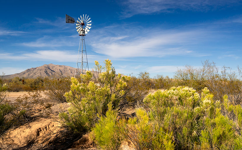
The enchanting snowscapes we’ve shared recently have sparked a sense of wonder and hope. They offer more than just a visual feast; they promise water—our desert’s lifeline. While winter’s chill entices snowbirds to the desert’s warm embrace for leisurely golf, the irony is stark; these dry, sunny days often come at the expense of precious groundwater pumped tirelessly to maintain verdant fairways.

Yet, behind this recreational facade lies a stark reality that Arizona has grappled with for over 20 years: an unyielding drought. It has depleted reservoir levels at historic lows and water tables, setting the stage for ecological challenges. From bark beetle infestations decimating Ponderosa pines to our iconic saguaros standing beleaguered under the strain of aridity, the impact extends beyond plant life. Wildlife, too, has felt the pinch, venturing ever closer to human settlements in an urgent quest for hydration.

In this delicate balance, even humans’ habits are shifting. Golf courses, once lush and abundant, are re-evaluating their water use. Cities across the Southwest, including Phoenix and Las Vegas, face the reality of water scarcity. We are reminded that water is a finite resource that requires our respect and careful management.

A Silver Lining in the Clouds

Nature’s wheel turns, and recent winters have brought whispers of change. Snowflakes and raindrops have graced our arid state more generously, hinting at a shift in the tide. Could this be the beginning of the end of Arizona’s long dry spell? Our hearts cling to hope.

We understand that recovery is a marathon, not a sprint. One season of abundant rain doesn’t herald the end of a drought; it is merely a single step. The land is thirsty—its water tables are like empty wells waiting to be refilled. Our great reservoirs, Lake Mead and Powell, exhibit their white rings—a bathtub’s stain that marks levels of plenty long gone.

This Week’s Reflections

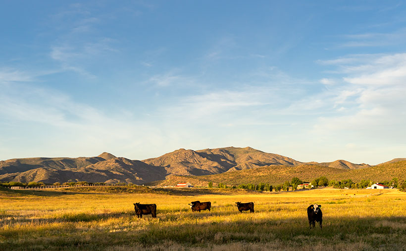
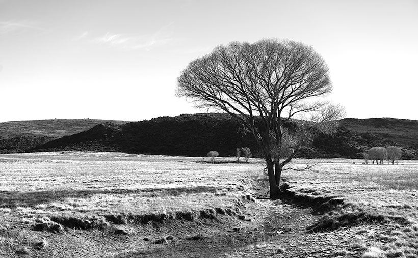
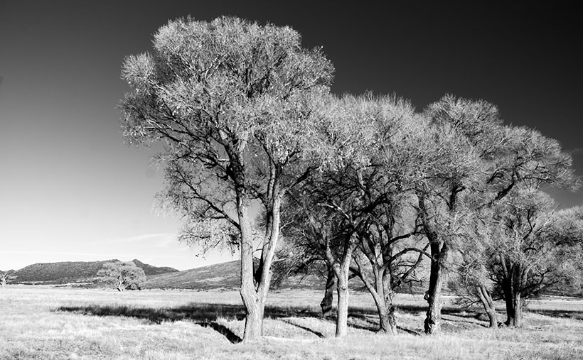
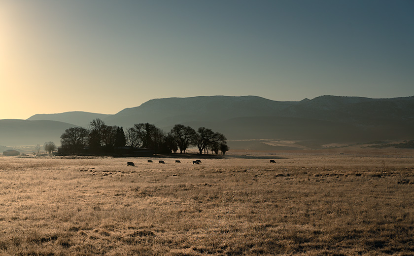
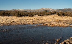
This week’s images—a frozen puddle and grazing cattle in a frost-touched field—are snapshots of this hopeful chapter. They’re visual stories of the land in a rare, quenched state, testaments to the resilience and adaptability of life in Arizona.

As we marvel at the snow-capped peaks and frost-adorned fields, let these recent rains be a sigh of relief and a symbol of nature’s enduring cycle. It’s a cycle that echoes resilience and renewal, qualities deep within the Arizonian spirit. While we cherish this momentary abundance, let’s carry forward the wisdom it brings—to live in harmony with our desert’s rhythms and conserve every resource.

Close-up of a frozen puddle in a frosty field with the Weaver Mountains in the background on a cold Arizona morning
Morning Freeze: Ice Takes Hold in Peeples Valley – A stillness descends on Peeples Valley as dawn reveals a frozen puddle amidst the fields, with the majestic snow-capped Weaver Mountains in the distance.

Our beautiful, rugged state narrates stories of the past and hums with songs of the future, a reminder that as we hope for wetter winters, we must also adapt with creativity and care. We step forward with a sense of stewardship, treasuring each precious drop and each frozen morning as gifts to be respected and protected.

May our appreciation deepen for the water that sustains us and the entire tapestry of life that thrives in our majestic desert. Until the next rainfall, we remain vigilant and thankful, for we understand the value of the desert’s offering.

I invite you to view these moments captured in time, visit my website <Jim’s Site> and Fine Art America page <FAA Link> for larger versions, and witness the unusual beauty that unfolds when winter visits the desert.

Until next time, keep your canteens handy and your humor dry.
jw


Survey and Looking Forward

As we close the chapter on our March survey, there remains one last chance for your valuable feedback. Your insights are like the spring rain that nurtures this newsletter’s growth. Stay tuned—next week, we’ll unveil the survey results and explore what lies ahead for Arizona’s landscapes and this newsletter. Your voice matters, and I eagerly await sharing our future with you.

Feedback Form

Feedback Form

I feel these newsletters are sent:
I think the articles are:
I most enjoy stories about:

Seal Mountain Picture of the Week

I wouldn’t have made a good prospector if I had lived during the Weaver Mountain mining boom. Since it is Father’s Day, a quote from my dad seems especially appropriate today. “You’re nothing but a lazy bastard, and you will never amount to anything.” Thanks, dad. I’ll cherish those words forever. He’s right, though. I don’t even like to water our flowers much less pick at a mountainside. In last week’s post, I was shocked to see in the photograph of my hand, a callous below my ring. Where did that come from—I haven’t touched a hand tool in decades.

If mining is off my list, what else did men do to earn wages back then? To find out, I continued my exploration of the Weaver Range east side by following the other side-roads near Placerita. This week I drove the Wagoner Road down to the Hassayampa River. I’ve never seen that area, and besides, I might get different scenes for my drone film. I struck pay dirt (sorry for the mining metaphor).

The Wagoner Road descends the east slope of the Weavers into a river valley where the Hassayampa flows above ground. As expected, where there’s surface water, there’s farming—or in this case ranching—big ranches. They’re stacked along the river one after another. They have well-maintained fences, impressive gates, and lots of black cattle (although I did see a herd that had Wagyu markings). The valley reminded me of north Scottsdale when it was mostly Arabian horse farms. It would be an ideal place to live except for grocery shopping. There are only two ways out, the 38-mile road back to Kirkland Junction or crossing over the Bradshaw Mountains on the Senator Highway (Wickenburg is only 20 miles distant in a private aircraft, which is possible given the size of these estates).

Seal Mountain - A remote mountain only seen in an obscure valley is the model that was used on the Arizona emblem.
Seal Mountain – A remote mountain only seen in an obscure valley is the model that was used on the Arizona emblem.

Since I was scouting new views of the Weaver peaks, I found a doozy. It’s the mountain that is in the background of this week’s featured image that I call Seal Mountain. Every Arizonian should know this mountain by heart because it was the model used for the Arizona State Seal. In 1912, who knew it existed? The only place you can see this peak is from the ranches in this remote valley. I’m impressed, however, that my local mountain range is represented on the Arizona seal.

The Arizona Seal - If you squint hard, you can see the similarity.
The Arizona Seal – If you squint hard, you can see the similarity. Personally, I would have chosen Four Peaks.

So, could I have been a rancher instead of working in a mine? MMM—maybe not. That kind of work still involves toiling with shovels, rakes, other hand tools, and even possibly riding a horse. Horses don’t like me. The last one that I road said, “Oof,” when I got on. Let’s take a closer look at that state seal—shouldn’t there be a programmer or a Web designer on it? Come to think of it, there isn’t even a real estate agent, and that’s the number one Arizona job.

You can see a larger version of Seal Mountain on its Web Page by clicking here. I hope you enjoy it. Come back next week to see what else we found along the road to Placerita.

Until next time — jw

Meadow Cottonwood Picture of the Week

The part of Yavapai County where Queen Anne and I live is littered with the names of pioneers that came to Arizona looking for gold after the gold rush in California panned out. These places include the towns of Wickenburg, Yarnell, and Stanton—the Weaver Mountains—and Peeples Valley. I didn’t misspell the valley name. It’s not a great commune up there in the mountains, but a rather a lovely flat valley named after a prospector named A. H. Peeples.

I’ve mentioned him before in previous posts. With a set of initials like that, I was relieved (although disappointed) to find that his full name was Abraham Harlow Peeples. He was on an Army expedition lead by Captain Joseph Walker and guided by Pauline Weaver—who, despite the name, was a man. While camping along a creek, some horses (or mules, depending on which story you read) wandered off during the night. Walker sent a couple of wranglers to fetch the animals. When they returned to camp, they talked about gold on top of the hill and showed pockets full of nuggets. Peeples and the rest of the party went to see for themselves. Arizona Place Names said that Abraham picked up $7,000 in gold before breakfast—and that’s in 1863 money. Anyway, he used his new wealth to build a ranch in the valley that bears his name.

Before Anne and I settled in Congress, we looked at several homes up there. It has advantages. With a higher altitude, it has milder summers but doesn’t get snowed in during winter. The valley has beautiful mountain views with the Bradshaw’s to the east the Weaver Range on the south. The little town has a bar and convenience store. What more could you want? However, the closest grocery store is the Safeway in Wickenburg, and that’s where we buy groceries now—fifteen miles in the other direction.

The Maughan Ranch owns most of the land in the valley, and they keep adding to their property. Along Az. 89, there are painted white fences, with black cattle grazing behind them. Our real estate agent joked that the painters are full-time staff because they’ll never finish.

Meadow Cottonwood - a single tree grows in a meadow ravine ensuring a good water supply.
Meadow Cottonwood – a single tree grows in a meadow ravine, ensuring a plentiful water supply.

Lucky for me, the fences don’t block the view of the trees featured in this month’s set of photographs. For this week’s featured image—called Meadow Cottonwood—I leaned against the fence to brace myself when I snapped the photo. This dormant cottonwood is a middle-aged tree that found a meadow ravine to grow in. Backlit by the sun, I’m happy how the delicate branches contrast against the white sky.

You can see a larger version of Meadow Cottonwood on its Web Page by clicking here. I hope you like it. Be sure to come back next week for another cottonwood portrait from Peeples Valley.

Until next time — jw

Cottonwood Grove Picture of the Week

I want to begin this week’s post by thanking Deb Poteet for her advice about wearing fish-net stockings. If you missed what she said, it was a helpful comment to last week’s post. She said that she got her information straight from the Candy Store dancers—the gentlemen’s club on Cave Creek Road near Costco. It made both Queen Anne and me wonder what she was doing hanging around old strip clubs. Deb really does surprise us sometimes.

On another subject, Her Majesty is improving with each day. She goes to physical therapy three times a week and limps around the house without her walker or a cane. When I remind her that she doesn’t need to do that, she drops the Chester impersonation. It’s interesting to see how fast a woman can recover when you walk up to her death bed with a bottle of Dawn dish detergent and ask, “How much of this do I put in the dryer?”

Cottonwood Grove - A small grove of cottonwood grow along a dry brook in Peeples Valley, Arizona.
Cottonwood Grove – A small grove of cottonwood grows along a dry brook in Peeples Valley, Arizona.

Meanwhile, back up the mountain in Peeples Valley, and the second in my series of cottonwood tree images. This week’s featured image that I call Cottonwood Grove was another image taken on the Maughan Ranch north of town. Like other members of the Poplar family, these large fast-growing trees only grow where there’s a good water supply. In this image, there’s about a half dozen growing along the banks of a dry brook, which eventually feeds Kirkland Creek. Scenes like this one are familiar throughout the west.

In an Arizona Geography class that I took at Arizona State University, the professor told us how the trees filled the length of the Salt River bed. A family of beavers dammed the river under the Mill Avenue Bridge while the river still flowed. When the Corps of Engineers built the dams east of town, the Salt River stopped flowing, and the trees died, rotted, and eventually, a summer monsoon storm blew them over. That would have been a swell topic for a photo essay, but I wasn’t here then.

You can see a larger version of Cottonwood Grove on its Web Page by clicking here. I hope you like it. Be sure to come back next week for another cottonwood portrait from Peeples Valley.

Until next time — jw

Desert Broom and Windmill Picture of the Week

I’ve spent a lot of time in the desert recently. I’m less likely to run into snakes now that the weather is colder. But, there’s still a lot to be wary of when you’re out in the wild. There’s the cactus, especially the Jumping Cholla, the barbed wire, and all the illegal garbage scattered along the trail. One of the most frequent things I have to avoid is all of those cow pies. As I move, my eyes are on the ground; then, I stop to look up to get my bearings. There may not be a cow within miles, but their droppings are everywhere. I Googled it and found a state agricultural Website that said, “Grazing fields account for 73% of total land use in the state and 98% of its agricultural landholdings.” That’s a lot of free-range lands.

Desert Broom and Windmill-The picturesque windmills don't provide an efficient supply of water to cattle as water tables drop
Desert Broom and Windmill-The picturesque windmills don’t provide an efficient supply of water to cattle as water tables drop

You can tell ranching in Arizona is a big deal by the number of windmills and clumps of green trees you see as you drive down the highway. The green areas are usually associated with stock-tanks—the ranchers plow low dams on washes to retain the run-off, and the windmills pump groundwater into large metal tubs from which the herd gets a drink.

Not many of these windmills actually spin these days, regardless of how much the wind is blowing. Some of that is because the water table is dropping. There has been an ongoing drought here, and we’ve pumped enormous amounts of water out of the ground over the years. Instead of drilling the wells deeper, ranchers disable the windmills and truck water in to fill the tanks.

On our “One Lap of the Harquahala Mountains” tour that Queen Anne and I did last month, I was challenged with either shooting the mountain repeatedly, or finding interesting things that broke the monotonous sea of creosote, so when I saw this windmill off in the distance, I hiked in for a shot. When I got there, I liked the shiny metal fan against the sky, but I wasn’t impressed with its doughboy style galvanized tank. It looked as if thirsty bovine stampeded over it. Luckily there was some desert broom nearby that helped in a couple of ways. The green plants were in bloom—that’s as close as you get to fall color in the Sonoran Desert, and they camouflage the damaged tank.

I named this week’s featured image Desert Broom and Windmill. I like how the light was beginning to come in and how Harquahala Mountain shows in the background. I’m also partial to the high cirrus clouds, so I was pleased that they frame the windmill’s blades.

You can see a larger version of Desert Broom and Windmill on its Web Page by clicking here. I hope you enjoy viewing it. Join us next week as we continue along our trip around the Harquahala Mountains.

Until next time — jw