Morgan Estate Temecula, California

Morgan Estate - The Morgan family has lived in this home since 2002, and five years ago they spruced up the place for their daughter's wedding. It went so well that they opened the estate for weddings of patrons that can afford the ante. Since then, it's become a popular place to get hitched.
Morgan Estate – The Morgan family has lived in this home since 2002, and five years ago, they spruced up the place for their daughter’s wedding. It went so well that they opened the estate for weddings of patrons that could afford the ante. Since then, it’s become a popular place for couples to get hitched.

When Queen Anne and I embark on photo shoots requiring an overnight stay, we try to indulge in a fancy dinner to express our mutual appreciation. While we rely on websites such as Trip Advisor for dining recommendations, we’ve noticed that they often suggest generic options like burgers, pizzas, or Mexican food, neglecting many exceptional dining spots in the region, especially those nestled within wineries.

These winery restaurants may be pricey but they offer a unique dining experience. The chefs here are culinary maestros, creating gastronomic masterpieces with each dish. They provide upscale and luxurious options for special occasions and are an essential stop for wine lovers. Amongst the many wineries in Temecula, Leoness Cellars stands out as a must-visit spot.

Leoness Cellars’ tasting room is like an adult Disneyland, with more wine and fewer screaming children. As soon as you arrive, you’ll be greeted by the vineyard equivalent of a fairytale castle, except there’s a sparkling fountain instead of a moat. And instead of knights in shining armor, a team of friendly wine experts is ready to guide you through the tasting experience.

Its floor-to-ceiling windows offer breathtaking views of the vineyards. They have an extensive selection of wines to suit any palate, from rich and bold reds to crisp and refreshing whites. And if you’re feeling intimidated by the complex world of wine, their friendly wine experts are on hand to guide you through the tasting experience of a lifetime. The tasting room is more like a sophisticated wine cave, with rustic wooden tables and cozy leather chairs, perfect for relaxing while you savor the unique flavors.

One of the most exceptional features of Leoness Cellars is the food pairing experience. It’s an absolute match made in culinary heaven – the wines are expertly paired with small bites, leaving your taste buds in pure bliss. The experience is so indulgent that you might even be tempted to make out with your glass of wine (but please don’t; that’s weird). During our visit, Queen Anne and I paid $25.00 to share a flight of 6, and we savored the 2021 Viognier, the 2018 Meritage, and the 2018 Syrah—my favorite. We did notice that the pouring sizes, in general, are getting skimpier. To put it in perspective, imagine getting your favorite wine glass from the cupboard and spitting into it a couple of times; that should give you an idea of the serving size. We realized we were being pathetic when our hostess had to stop us from elbowing each other to get to the glass first.

After the tasting, we went to the restaurant patio for lunch. We ordered full glasses of the wines that impressed us, savoring each sip and bite while basking in the warm sun. The day couldn’t get any better with full bellies, fine wine, and a picturesque view—except for maybe a nap.

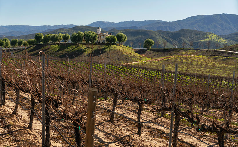
I hope that this week’s photo, titled Morgan Estate, captures the natural beauty and sophistication of Temecula’s wine country. The lush wine groves in the foreground and the majestic Santa Ana Mountains in the background create a stunning backdrop for the photo’s focal point – the Morgan Estate. I took this photo from the restaurant patio during lunch when I couldn’t resist snapping a shot of this breathtaking view. It’s the kind of view that makes you want to grab a glass of wine and bask in the tranquility of the surroundings.

The Morgan Estate is a popular wedding venue in the area, and it’s easy to see why. The estate’s sophisticated elegance perfectly complements the region’s natural beauty, making it the ideal spot for brides to slap on that ball-and-chain. From the vantage point of the restaurant patio, you can appreciate the estate’s grandeur beneath the majesty of the Santa Ana Mountains. I tried to encapsulate the region’s allure in the photo- from the vineyards’ rolling hills to the estate’s sophisticated charm. I hope my photo encourages you to get off your couch and plan a trip to Temecula to enjoy your slice of La Vita.

Leoness Tractor - The cellar's owners drug this old tractor out from the barn as yard-art.
Leoness Tractor – The owners of the cellar drug this old tractor from the barn as yard art.

You can see a larger version of Morgan Estate on its web page by clicking here. Next week—after I dry out—we’ll begin April’s series of show-and-tell. Come back then and see where the road takes us.

Till next time
jw

BTW:

Visiting wineries and sampling their offerings has brought us joy over the years. While putting together this month’s project, we’ve considered the idea of writing reviews for each of the farms that we visited. However, with over 40 cellars open for tasting in Temecula alone, we couldn’t visit them all without having my liver shrivel and fall out. During this trip, we paced ourselves and saw a couple of places in the morning, had lunch, and then stopped at another two in the afternoon. We found that the wine flavors began to run together if we visited more than that.

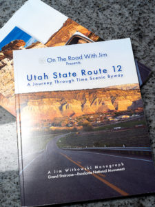
I’m considering an idea for a book that covers all the regions we’ve visited. However, putting together a book covering five vineyards in each of the 15 California wine regions with five pages of photos and text would be monumental. The book would be over 300 pages long. Instead, I’m considering breaking the task into bite-sized pieces and publishing them in a magazine format, similar to my Utah State Route 12 magazine. Each publication would have about 50 pages, making them more affordable than hardcover books. I would publish three or four per year, leaving me time for other assignments.

I’m interested in hearing your thoughts. Would you like to see a project like this? Or would you prefer that I stick to pretty landscapes and roadside relics and never talk about wine again? Please share your comments below, and while you’re there, click on the “Like” button if you enjoyed this post. Don’t worry; no one will know you did it.

Dragon Backs Picture of the Week

Dragon Backs - A pair of peaks in the Dome Rock Mountains that look like spiny back dragons.
Dragon Backs – A pair of peaks in the Dome Rock Mountains that look like spiny back dragons.

The drive between Quartzsite and Yuma on Highway US 95 has two parts. Driving in either direction, it’s thirty miles of gentle uphill grade and then downhill for the other thirty. The mid-point is at Stone Cabin (now an empty building shell), where the Border Patrol checkpoint is.

From Quartzsite, the road is dead straight, and your line of sight is limited only by the whoop-de-woos (wash dips) and the earth’s curvature. The 800-foot climb is barely noticeable, and the road is flanked on the east by the KofA Mountains (named for the King of Arizona mine), and to the west are the Dome Rock Mountains (the dome you see west of downtown Quartzsite).

The south half of the trip has a steeper grade—most of which is in the first mile, where the highway drops off a hill. The scenery changes too. There’s a different mountain range far off to the east—the Castle Dome Mountains, but you’re surrounded by the Yuma Proving Grounds, where the military plays with its new toys. Instead of a pleasant drive through the wilderness, you begin searching for things like the down-looking radar dirigible, a Bradley tank using your car for target practice, or the C-130 that just took off and climbed to 10,000 feet before troopers shove something big out of the back—I sure hope that chute opens.

Whenever Queen Anne and I travel this road, I look for these landmarks to help pass the time. I’d rather have a stimulating conversation about physics with her, but she usually has her head pressed against the headrest, her eyes closed, and her mouth open. She stays that way until one of her snorts wakes her.

On the drive home, one of the landmarks I look for is a pair of unnamed mountains in the Dome Rock Range. When I pass them, we’re nearing the Quartzsite city limits. The twin peaks look like a pair of dragons sunning themselves on a rock. I’ve often thought I’d like to get their portrait, but no matter how much map scouring I do, I’m unable to find a way to get closer—short of hiking two and a half miles across the open Mohave Desert.

The spiny back of the dragons climbs from the desert to their west-facing heads—where they watch the Colorado River flow south. As with last week’s shot, we always drive by them right after lunch. That’s the absolute worst light in the desert. I keep swearing on a stack of Ansel Adams books that I will shoot them when the light is correct, but it’s yet to happen.

On our last drug run—when last week’s photo was taken—clouds were gathering over the Dome Rock Range, so instead of a uniform blue sky, there was texture over the mountains. After I took the KofA Thunderhead shot, I walked across the highway and pointed my camera at the dragons. This time I twisted the zoom to telephoto and framed the monsoon clouds. The result is this week’s featured image, which I call Dragon Backs.

You can see a larger version of Dragon Backs on its Webpage by clicking here. Next week, I have pictures to show from a different place for show-and-tell. I hope you can take a break from your Christmas shopping and take a look. We’ll see you then.

Till next time
jw

BTW:

Flagstaff Book - A collection of photographs and musings from our summer trip to Flagstaff.
Flagstaff Book – A collection of photographs and musings from our summer trip to Flagstaff.

Oops, I Did It Again (Britney Spears song written by Richard Thompson). I published another book. This one covers all of the places we visited in and around Flagstaff. As usual, it’s available in two versions. You can see and buy the hardback on Blurb.com—which you won’t do because it’s too expensive—and the free PDF version you can download, view, and print from your computer. There are additional photos in each of the four chapters, so I’m hoping you take a look. You can get to its Web Page by clicking here.

Motel Du Beau Picture of the Week

Motel Du Beau - This 1929 establishment was one of the first to cater to tourists driving those new-fangled motor carriages.
Motel Du Beau – This 1929 establishment was one of the first to cater to tourists driving those new-fangled motor carriages.

When Queen Anne and I spent a week in Flagstaff last month, our primary goal was heat relief, but I was confident that I could snap a few shots of historic buildings and signs to add to my Route 66 collection. In this journal, I’ve written several times about my experiences traveling the Mother Road as a kid, so I’ll spare you from repeating them. Instead, I must say that I was disappointed at how hard it was to find kitschy motel and dinner signs along the main street. More profitable strip malls and professional offices are rapidly replacing them. Interstate 40 travelers prefer the newer hotels on Butler Street, where the Little America Hotel is. Nobody drives 66 anymore—too many lights and too much traffic.

John Steinbeck’s novel The Grapes of Wrath, the depressing story of dust bowl migrants, searching for survival, didn’t make Route 66 famous. Nor did that fame come from my father’s generation, who—like the Joad family—moved en masse to California after World War II. It came when Angel Delgadillo—the Seligman barber—pitched a historic highway idea to the State of Arizona. When that designation came through, tons of beer-guts had a play-pen to gather and drive their car toys. We’re dying off now, and like the coals in your Webber Grill, that passion is dying with us.

Master photographers Ansel Adam and Minor White influenced how I photograph the world. Still, in 1975, the George Eastman House showed a photo exhibition called The New Topographics: Photographs of a Man-Altered Landscape. The show still floats between museums today. It was a collection of ten photographs made by ten photographers that were opposite the landscapes I embraced. It was heresy. The photos are stark images of industrial buildings and houses devoid of people. I didn’t even think some of the artists printed very well. But I did kind of like the ones John Schott did. His pictures were of Route 66 motels. You can see where this led.

Flagstaff Train Depot - Either this is new or I've been blind, but the coolest Route 66 sign that I saw was the train station's address.
Flagstaff Train Depot – Either this is new, or I’ve been blind, but the coolest Route 66 sign I saw was the train station’s address.

I’ve considered compiling a book of my Route 66 photos. I have several, but most are from Arizona, with a couple from California and New Mexico, but nothing east of Texas. If this horse hadn’t been flogged to death, I still could work on my own Mother Road project. Now that I’m retired, I have time. I figure a month on the road should do it. To do it properly, I’d have to drive a classic car—something from the ’50s or ’60s. However, it needs air-conditioning, cruise control, and a good stereo (I won’t put up with AM radio stations dropping out under bridges). My ultimate ride would be a red ’62 Corvette—like the one Buzz and Todd drove—but hold the whitewalls. I could haul my camera equipment behind it in a small aluminum trailer like the autocross guys lug their race tires. October is a perfect month for a road trip, so if anyone out there wants to be my Angel investor, let me know. You’d get all the bills, half of the proceed, and a free book out of the deal.

This week’s featured image is of a prominent Flagstaff landmark. It’s called Motel du Beau, and the subject is the sign. It’s one of three hotel signs towering above the city (can you guess what this month’s project is). With the Lowell Observatory on top of the hill, Flagstaff has adopted a dark-sky policy, so the zoning people would never allow these enormous signs in town. If they weren’t historical landmarks, the city would tear them down.

In the late 1920s, Albert Eugene Du Beau vacationed in northern Arizona and envisioned a new way to make money. Instead of building a multi-story building for railroad and train travelers to stay, why not create a place for people traveling in these new-fangled motor cars? So, he designed and built a single-story motor-hotel (later shortened to motel) to be convenient to unload and load their vehicles in 1929. His design featured a U-shaped layout with steam-heated garages (they burned down in a 1970s fire) and indoor toilets. He built his motor court adjacent to downtown’s main street, which was brilliant because, in time, the busy highway became Route 66. The Motel Du Beau was one of the pioneering businesses to use neon signs and elevate them on towers.

In today’s modern world, the Motel Du Beau still looks like a nice place to stay, with rooms starting at $75—a far cry from the original price of $2.50 per night. Their website shows various room types, and they have a lovely little wine lounge called Nomads. I’d certainly be willing to try it after they reopen the bar.

I hope you enjoy seeing a part of Flagstaff’s history. You can view my Motel Du Beau web version on its page by clicking here. Next week, we’ll look at another historic Flagstaff motel sign, so be sure to join us then.

Till next time
jw

Galleon Tile Picture of the Week

Galleon Tile - One of the more unusual tiles that I found in Avalon.
Galleon Tile – One of the more unusual tiles I found in Avalon.

Unless you’re one of those people oblivious to the world around them, one of the first things you notice as you walk from the ferry to your hotel is ceramic tiles. They’re everywhere. They’re on the buildings, walls, and stairs, covering the central fountain on Crescent Street. You may wonder, “What’s up with all those tiles?” To help explain, here’s the Cliffs Notes version of the history of the tiles.

The soil in Southern California—including the Channel Islands—has abundant clay deposits. That’s a good thing if you’re a potter or want red tile roofs adorning Spanish Revival Architecture, which is historically prevalent in the L.A. basin. It’s not something I’d do, but after William Wrigley (the chewing gum tycoon) bought Catalina, he thought he’d benefit somehow if he lured some tourists there. One of his strategies was to add glitz to the drab buildings—like putting ornaments on the Christmas tree, as it were. He’d seen the Mediterraneans adorn their homes with ceramic tiles in his worldly travels. So in 1923, he started the Catalina Pottery and Tile Company. The factory started manufacturing traditional Moorish designs but added pictorial tiles featuring exotic birds, fish, and large-scale murals as they grew. They were an instant hit.

Southern California architects and designers wanted them for their projects, so the tile company soon began shipping the colorful ceramic squares to the mainland. Their popularity spread like wildfire, and in the ’20s and ’30s, the Catalina Tile Company sent products worldwide. Sadly, fashion is fleeting, and the demand for Catalina tiles declined in the late ’30s early ’40s. Eventually, the Wrigleys shut down the factory.

Avalon Fountain - The water fountain in the center of Avalon's business district, is covered with Catalina tiles.
Avalon Fountain – Catalina tiles cover the water fountain in the center of Avalon’s business district.

Years of vandalism and neglect began to take a toll on the historic Avalon tiles. After the turn of the millennium, Avalon’s city council hired a local artist to restore the town’s central fountain (unfortunately, I couldn’t discover her name). Still, the legend says that homeowners commissioned her to bring the rest of the town back to life once she began working on the fountain. She hand-made copies of the originals and didn’t have time for other projects. She spent the remainder of her life restoring Avalon’s history.

During our May visit, I assigned myself a sub-project. Before Queen Anne rose from the dead in the mornings, I got up and scoured Avalon for unique tiles. The Moorish patterns found on the walls and fountain are common, but I was hunting the pictorial specimens—like a personal scavenger hunt—or today’s geocaching like my brother-in-law—Don—does. Along the backstreets, I found several unusual ones, and this week’s featured image is my favorite. It depicts Cabrillo’s (the Spanish explorer and first European to visit—and name—Santa Catalina) galleon. Someone glued it to the stucco wall of a residence. The tile looks new, although the wall is damaged. I included the stains and marring in this composition. I also really like the blue/yellow contrast in this image. I titled the photo Galleon Tile.

This is the final post of our Catalina adventure. It’s hard for me to leave and return to the hot, damp desert. Next month, I’ll start something new next week, in some other pleasant location. I hope you liked seeing my Avalon images and reading my stories. In case you want to see more, there’s good news. I published another new book titled Avalon—Romance Twenty-Six Miles Away. With this publication, I decided to skip Amazon because they don’t add to the marketing—they only tack on 15%. So, if I’m not going to sell books, I can not sell them in the publisher’s (Blurb) bookstore cheaper than not selling them on Amazon. But wait! I thought of you—my loyal subscribers. I sprung for a PDF version that you can download at no charge; that way, you can look at the additional pictures and print your copy for your library.

Avalon - The book is now available in the Blurb Bookstore or free to download here.
Avalon – The book is now available in the Blurb Bookstore or free to download here.
    • If you want to see the hard copy on its listing page (you can scroll through the book), click here.
    • If you want to download the free pdf version (you can save it to your hard drive), click here.
    • If you’d like to see a larger version of this week’s featured image, click here.

Till next time
jw

The Grotto Picture of the Week

Grotto Interior - From the outside, the Grotto looks like a secluded place to hide from the world.
Grotto Interior – The Grotto looks like a secluded place to hide.

Over the past couple of weeks, we’ve been hiking and photographing the Grotto Trail in the Chiricahua National Monument. I know that seems like a long time for a one-mile trail, but I’m old and quickly fall. As you’ve seen in previous photos, massive rock formations that sometimes resemble sculptures line the track. That’s another reason the hike takes me so long—I can’t pass up these shots.

As I walked through the towering erosion formations, I wondered how the grotto would look. By definition, they’re a ‘picturesque cave,’ so I wasn’t sure what I was looking for. I shouldn’t have worried because, as that old proverb goes, “You’ll know it when you see it.” That’s precisely what happened. When I first peeked through a side window, I shouted, “Eureka, I’ve found it.”

It’s a cool room with light filtering in from outside. Four pillars line the room and hold up a slab of stone that fell on top. If you aren’t my size, you can crawl up inside and take a nap or play tea-time should you happen to bring your Barbie set. Because it’s open to the sky, you wouldn’t be able to take shelter from a storm like you’d be able to do in an actual cave.

Grotto From the Trail - When I looked back at the Grotto from the trail, I could see how it was assembled.
Grotto From the Trail – I could see how it is assembled when I looked back at the Grotto from the trail.

After catching my breath for a minute, I started back to the parking area. I was only a few steps down the road when I turned around and shot this second image. It gives you a better idea of how the Grotto is assembled, and quite frankly, it doesn’t seem to be a secret room—just an interesting pile of rocks. You can see a larger version of The Grotto on its Web Page by clicking here.

Since today is the last Sunday of the month, this is the end of April’s Chiricahua project. I took many more pictures, but I couldn’t show you all of them in only four weeks. If only there were another way for you to see them. Oh wait, there is.

Wrote a book about it—wanna see it?—here it is.

Chiricahua National Monument – My new photo essay of our trip to Cochise County will be available on Amazon, but you get a free preview because you’re a subscriber.


I’ve been working on a book while talking with you to prove that I can walk and chew gum. It’s the second in my sampler photo essay series. This one is called Chiricahua National Monument, and it includes the photos I’ve shown this month, plus a couple dozen more. Chapters in the book cover the Faraway Ranch, the hiking trails, and the landscapes surrounding the park.

It isn’t listed yet, but like my last book—Snow Canyon—it will be sold exclusively on Amazon at a ridiculous price of $68.00—unless you want to order a half-dozen or more, I can get a discount for you. Otherwise, no one will pay that price. But because you’re loyal readers, I devised a way for you to read the book and see my other photos—for free. I ordered a PDF version that you can open and download using this link: Chiricahua National Monument. PDF. You’re welcome to download it, print it, and toss it in the garbage when you’re done. I hope you enjoy it.

Next week is a new month, and we’re not entirely done with Cochise County. I found some pretty things to show you outside of the park, so come back next week when we begin May’s project.

Till Next Time

jw

Snow Canyon—The Book      New book announcement

Do you remember from my first of this month’s post—Stacked Arches—where I said, “There’s enough to photograph within the park’s boundaries to fill a small picture book?” Well, there is—and I have—so I did. This short particular midweek post announces my latest book—Snow Canyon.

Snow Canyon - The Book - my latest book will be released next week, but you can get a sneak peak by clicking here.
Snow Canyon – The Book – my latest book will be released next week, but you can get a sneak peek by clicking here.

They haven’t released it yet; that will happen sometime next week on Amazon. It’s available in two versions. The first is a hardcover with a dust jacket. The paper I used was the best offered, so I expect the photos reproduction to be outstanding. The second variation has a soft cover and is printed on upgraded paper stock.

It’s a self-published book, like my others, so, unfortunately, its cost is prohibitive—unless you want to buy 100 copies or more. However, I wanted you—my subscribers—to enjoy it, so I’m providing a link to a free version in PDF format as a way of saying thanks for hanging out with me.

Once you download the PDF (2MB), you can read it, print it, tape it to your fridge, or line your parrot cage. It’s yours to do as you wish. Get your copy by clicking on the cover shot above or on this link: Snow Canyon—The Book.

I hope your New Years’ celebration is safe and sane. I’d like you to be around next year when we go to many exciting new places.

Now, we will return to our regularly scheduled programming.

Until next time — jw

State Route 12 Project New Publication Announcement

Utah SR 12 Magazine
Utah SR 12 Magazine-84 pages of color photos and stories printed on premium paper and you can buy on its Blurb Page.

There’s exciting news this morning coming from the international headquarters of Jim Witkowski Photography, located in beautiful downtown Congress. You may have wondered why things have been quiet around here for the last six months, or that I didn’t post many photos from our Utah trip last summer. Well, I was busy using that time to compile years of photographs into my new 84-page magazine—Utah State Route 12, and I’m pleased to announce that it’s ready for début.

The project’s theme is about the beautiful places in the Escalante Grand Staircase National Monument. The monument is so vast that it has three management areas: the western Grand Staircase Region, Kaiparowits Region, and Escalante Canyon Region on the east flank. There is only one paved highway that spans them all—Utah’s State Route 12. In this project, I wanted to show that there are beautiful marvels to see along its length, and the road is more than just a gateway to Bryce Canyon.

I plan to release my work in four versions: PDF, Magazine, Book, and eBook. I have completed the first two, which—I believe—should get the most attention, and I’m still working on the second half. It looks like they will be ready by Valentines. (Are you in the dog house and need a gift?)

PDF—this version is best for viewing on your computer, and except for bandwidth, it’s free. It’s ideal for those of you that don’t need more clutter. You can open the file and begin browsing right away or save it to your hard drive for later.

Magazine—this is a 84-page hard copy of photos and text printed on premium stock paper. I’m delighted with how well the images reproduced. The magazine’s cost is $ 22.99 (plus shipping) is admittedly pricy for a periodical, but compared to the book, it’s a bargain. Blurb handles the sales on their secure Website because they print them to demand. That means that there won’t be surplus versions lining birdcage bottoms.

Book—the large (13 x 11) coffee table book is still in progress which sounds simple, but it’s in landscape orientation, so the layouts have to be adjusted. The photos are larger than the magazine’s, and I had more space to embellish the stories. It will be available in softcover, hardback image wrap, and hardback with dust jacket. The price of the book is expected to be under $ 200.00 at most, so I think there will only ever be one edition—my own if Her Highness lets me.

EBook—this will be the last version and will be easy to do because it’s the book reformatted to fit your Kindle. That’s all handled by the computers. I don’t know what it will cost, but it will be ready next month, so keep watching my Books sections. The downside is that with this version, you won’t get the privilege of collecting dust with it.

I’m planning on releasing a new project each year as Queen Anne, and I travel. For this first project, I had to learn the software and build the templates; something that took up development time. Future projects should go from camera to print quicker. Plans for next year’s project are in progress.

You can get your free PDF version and preview the magazine by visiting their Web Page by clicking here. I hope you enjoy viewing them and please leave your comments here and/or on their Blurb page.

Until next time — jw