Ajo Mountain Foothills Picture of the Week

In my post a couple of weeks ago, I tossed out the fact that Organ Pipe Cactus National Monument was established in 1937—Franklin Roosevelt proclaimed it on April 13th, to be exact. In the subsequent weeks, we’ve explored the east side loop, which shows off the beautiful and rugged Sonoran Desert. So we accept that the monument is worth traveling a half-hour south of Ajo to visit—in fact, 22 million people did that last year—but in 1937, who knew?

If you look at a 1935 Arizona road map, you’ll notice that there isn’t anything south of Ajo except for the Papago Indian Reservation (They now call themselves Tohono O’odham, which means “Desert People” in their language—Papago is a derogatory derivative of a Spanish word for “Bean Eaters”). The only settlers in the Monument area were the Grays—a ranching family who bought up several local homesteads. So, how did word get back to the president about this unique area?

I came across one story that I liked, and I hope it’s true. In the Wikipedia listing for Organ Pipe Cactus National Monument, I found a line that says, “Land for the Monument was donated by the Arizona state legislature to the federal government during Prohibition knowing that the north-south road would be improved and make contraband alcohol easier to import from Mexico.” Of course, the very next words are “Citation needed.” It sounds too good to be true, but it also sounds like something the Arizona Legislature would do. A fact that makes me skeptical is that Prohibition was repealed in 1933, four years before Roosevelt’s proclamation. If the story is true, the smuggler’s highway has become the main thorofare to the Arizona Riviera—Puerto Peñasco—or as we Zonies call it, Rocky Point.

Ajo Foothills - Organ Pipe and Saguaro grow on a hillside below rugged cliffs in the Ajo Mountain Range.
Ajo Foothills – Organ Pipe and Saguaro grow on a hillside below rugged cliffs in the Ajo Mountain Range.

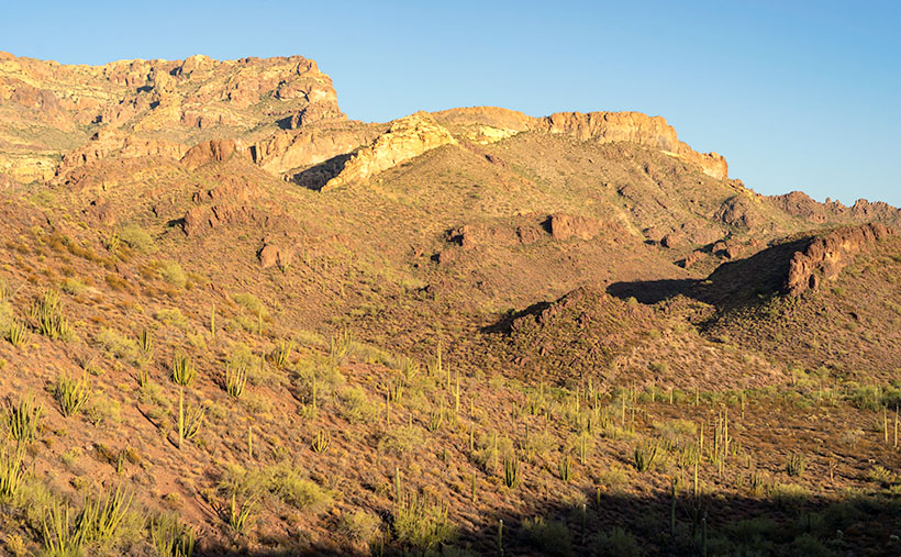
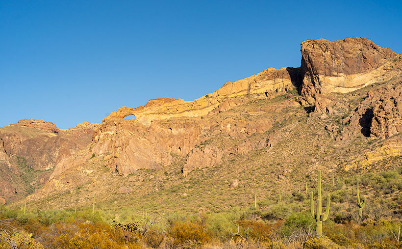
This week’s featured image was taken on the Ajo Mountain Loop’s downside as the road descends into a valley among the foothills. The shadows were getting long when I took the shot, and you can see Organ Pipe and Saguaro growing on the hillside below the rugged cliffs of Rhyolite and Tuff. I call this image Ajo Foothills.

I really enjoyed my afternoon at the monument. I want to return and drive the western loop. I want to take the Ritz and spend a night under the stars. Maybe we can do that next year when we’re able to move about the country again freely. Besides, there are other beautiful places in Arizona that we can show you in the coming months.

You can see a larger version of Ajo Foothills on its Web Page by clicking here. Come back next week when we begin another adventure traveling Arizona’s back roads.

Until next time — jw

Arch Canyon Picture of the Week

Organ Pipe Cactus National Monument has two vehicle loops that allow visitors to explore the park beyond the visitor center. On the west side of Highway 85 is the Puerto Blanco Drive, which is over 40 miles long and has stretches that require four-wheel drive. East of the highway is the Ajo Mountain Loop Drive, which is half the length and can be navigated in your family sedan (in good weather). Since I was only there for an afternoon, I opted to take the latter route.

I suppose if you didn’t stop to look at anything, you could follow this route through the Ajo Mountain Foothills in less than an hour traveling at the posted speed, but I spent more than three hours on the 19-mile loop because I was constantly hopping out of the truck taking pictures and gawking. In all that time, not once did I see another person—not even a ranger.

The road heads north-ish along the foothills’ west flank from the visitor’s center until it climbs over a pass at Arch Canyon. Then the road returns south through a valley between Ajo Mountain and its foothills. This week’s featured image was taken at the trail’s high point at Arch Canyon. There I was surprised to discover—an arch! Who knew? And it’s a good-sized one. I don’t recall seeing it in any of the park’s brochures, which I find odd.

Arch Canyon - At the north end of the Ajo Mountain Loop, you'll find the picnic grounds at Arch Canyon with an unnamed arch overlooking the area.
Arch Canyon – At the north end of the Ajo Mountain Loop, you’ll find the picnic grounds at Arch Canyon with an unnamed arch overlooking the area.

The arch doesn’t have a name on my topo maps. They only note the location of the natural arch. Maybe I could petition them to call it Queen Anne Arch. If the park service did that, maybe I could get her butt in the truck to see it. There is also a picnic area and campgrounds in Arch Canyon, but only tents are allowed. I guess that’s good because the camp would be packed with motor homes and fifth-wheels all year long.

This would have been a perfect opportunity to fly my drone so that I could get a shot that was closer and from a higher perspective. Alas—there’s a double drone prohibition in place here. Drones are not permitted to fly in National Park or National Monument airspace (although winged RC airplanes are permitted). Also, most of the Organ Pipe Cactus National Monument is designated as a wilderness area. Only a dozen yards on either side of the roads are the exception. All motorized vehicles are banned from wilderness areas.

While I was in the picnic area, I took some time to read the wonderful signs that the Park Service puts up to explain the views. I learned something that I’ve wondered about for years. The Ajo Mountain Range is part of the much larger ancient Pinacate volcanic field covering more than 1,900 square miles. The Pinacate Mountains are south of the border, about halfway to the Sea of Cortez. Over eons, this field had violent eruptions that spewed tons of magma, and alternately it had periods where the volcanoes spit out tons of ash and relatively little lava.

You can see a streak of light-colored rock near the ridge’s top in this week’s image. The darker rock is our old friend Rhyolite, the slow-moving magma found in the KOFA Range. The lighter streaks are from the ash falling from the sky and covering the ground. The ash layer is called Tuff, and I’ve seen it throughout Arizona—(and that’s the rest of the story, g’day – as Paul Harvey used to say).

You can see a larger version of Arch Canyon on its Web Page by clicking here. Come back next week to see the down hillside of the Ajo Mountain Loop.

Until next time — jw

2021 Wall Calendars Are they worth the price increase?

Warm Springs Cholla - Cholla along the roadside provide a good foreground contrast for McHeffy Butte at sunset.
Warm Springs Cholla – Cholla along the roadside provide a good foreground contrast for McHeffy Butte at sunset.

It’s calendar time again. Last year we got a nice response, but things have gotten worse like the rest of 2020. After reviewing my printer’s price list and post office shipping costs, I can’t charge $10.00 each for them. I sell these calendars at my cost, and this year they’ll cost me 17.75 to print and ship. To me, that moves them out of the stocking stuffer range, and they’ll be more expensive than picking something up at Costco or Walmart. But, if enough of you find that there is still value in my little calendar, I’m up for producing one.

Because the pandemic kept  Queen Anne and me from traveling out of state this year, I’ll pick out a dozen of my best blog shots. The size remains the same—6 ½ inches high (each half—about the size of a sheet of paper folded in half) and 8 ½ inches wide, and they have holidays noted on the dates. They’re printed on card stock—which is part of the expense.

If I can get five or more orders, I’ll put them together and place an order, but I need to know by November 1st to make a go/no-go decision. That gives me enough time to ship them in November before the holidays. If you’d like one, you can leave a comment in this post, use the contact form on my website (https://www.jimwitkowski.com/junk/index.php), or email me directly. Don’t forget to leave your contact information if I don’t already have it.

Until next time — jw

Organ Pipe Cactus Picture of the Week

There’s nothing rare or unusual about the organ pipe cactus. They’re a common sight in the Mexican states of Sonora and Baja. I’m sure that the local folks view them the way Zonies do the saguaro; they’re just another part of the local landscape. But, the saguaro’s smaller cousin only reaches into the United States in the national monument that’s a half-hour south of Ajo, and that’s what makes them special to us.

Like the saguaro, the organ pipe grows best on south-facing rocky slopes of the Sonoran Desert. So why don’t they grow further north? Well, that’s because they’re less tolerant of frost and won’t survive a hard freeze. The specimens that we have in our cactus garden have to wear styrofoam cup hats to get through even our mild winter nights.

Another difference between the columnar cacti is obvious by looking at them. The giant saguaro grows with a single trunk and sprouts arms after it reaches 50 years—like a tree. On the other hand, the organ pipe’s arms sprout from a stem close to the ground resembling a bush. Internally, their structures are similar to porous skeletons that allow the flesh to expand and store water.

While the saguaro and organ pipe’s flower looks the same, the latter’s are only open at night and are pollinated by bats. The saguaro keeps its flowers open in the day, which lets bees and doves help the pollination. Like the saguaro, the organ pipes produce fruit during the rainy season about a tennis ball’s size. The flesh is bright red and supposedly tastes better than watermelon. After eating the sticky fruit, birds disperse the seeds by defecating from the branches of palo verde trees.

Organ Pipe Cactus - This cactus specimen commonly grows in the Mexican states of Sonora and Baja, but only crosses the border within the boundaries the Organ Pipe Cactus National Monument.
Organ Pipe Cactus – This cactus specimen commonly grows in the Mexican states of Sonora and Baja, but only crosses the border within the boundaries of the Organ Pipe Cactus National Monument.

I drove a good distance on the Ajo Mountain Loop looking for a really nice organ pipe to photograph for this week’s featured image. The specimen in my image—called Organ Pipe Cactus—is a beaut, resembling an upside-down octopus on steroids. I’m a little upset that Ajo Mountain snuck in and photo-bombed my picture. At least you can see how far I traveled by how the mountain’s angel changed from last week’s photo. My references say that an organ pipe’s normal height is 10 to 16 feet, but this baby towered over my head and may have reached 20.

You can see a larger version of Organ Pipe Cactus on its Web Page by clicking here. Next week’s stop resulted in a surprise photo op. Be sure you come back and see what I found.

Until next time — jw

Ajo Mountain Picture of the Week

I turned my calendar over this week, and that means a couple of things to me; the best is that it’s the final quarter of 2020. In an average year, the hot weather finally breaks in a couple of weeks, because there’s an Arizona law that prohibits kids from Trick-or-Treating on a hot night. Of course, nothing about this year has been normal, so I’m not holding my breath. The Queen and I are looking forward to opening the house soon, and I’m anxious to take my drone out again and resume filming.

For October’s project, I drove south into the heart of the Sonoran Desert. As I said, we live along the northern edge of the saguaro country. We have a good population here in Congress and Wickenburg, but in other parts of the state, the giant cactus thrives. To show you, I traveled south of Ajo last week and drove the Ajo Mountain Drive loop in the Organ Pipe Cactus National Monument. The road is unpaved, but a sedan will make it as long as it’s not raining.

A couple of years ago, Anne and I visited the monument for the first time. I wanted to take this loop, but we didn’t bring an off-road truck. Plus, when she saw a sign warning of smugglers and illegal aliens, she said no. The park is 10 miles from the Mexican border, and 30 miles south of the old copper mining town of Ajo (evidently the Spanish found wild garlic growing in the area, so that’s how it got the name). The road passes through the middle of the Goldwater Bombing Range, so I’d recommend not stopping along the way to pick wildflowers.

The Monument is the only place where you can see large stands of Organ Pipe Cactus. They’re more common south of the border, but on this side—not so much. The two columnar cacti (saguaro and organ pipe) grow side-by-side throughout the park. With the dry summer that we’ve had this year, I was pleased to see that the specimens in the monument looked healthy and watered. The rain patterns in lower Pima County are different from home, and they had a better monsoon than we did. The cacti are packed in down there—if you could ever call a desert lush, Organ Pipe would be an example.

Ajo Mountain - The volcanic peak rises above its foothills in the Organ Pipe Cactus National Monument.
Ajo Mountain – The volcanic peak rises above its foothills in the Organ Pipe Cactus National Monument.

Ajo Mountain is the name of this week’s featured image, and in it, I was trying to show two things. They are the volcanic mountain—rising above its surrounding foothills—and how many saguaros are growing per square mile. These giants also seem significantly taller than our home-boys.

You can see a larger version of Ajo Mountain on its Web Page by clicking here. Next week we’ll stop further along the drive and show you the organ pipe cactus from which the monument gets its name.

Until next time — jw