The Gilded Road Home: Double Rainbows Over Congress Picture of the Week - Congress, Arizona

Double rainbows arching over State Route 71 with dark golden clouds and the Weaver Mountains in the background, Congress, Arizona.
Double Rainbows Over Congress: An Arizona Road Home – Explore a stunning double rainbow on Arizona’s SR 71. This golden hour capture sets the Weaver Mountains and road to Congress as the perfect backdrop

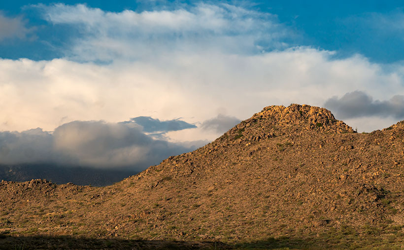
Welcome back to the final leg of our US 93 in the Golden Hour trip—it’s like a happy hour but with fewer hangovers and more lens flares. Last week, if you recall, we played hopscotch with raindrops beside the road, capturing the Date Creek Range in its full golden glory. After which, I hopped back in the truck, already chalking up the day as a wrap, convinced the photo gods had closed shop for the day.

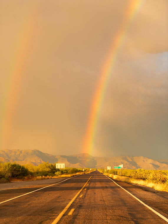
As I barreled down the highway, I noticed two glorious arcs of color in my windshield. It was like the sky had painted its version of Starry Night but with rainbows. These weren’t your garden-variety, quick-glimpse-or-you’ll-miss-’em types. They were vivid, full-arc, double rainbows. You bet I thought about stopping there—if only the road weren’t hogging the frame. Nature’s light show so entranced me that I almost shot past my exit. Veering onto the ramp like a last-minute shopper on Black Friday, I parked at the bottom, hoping to snag that elusive west leg of the rainbow. No dice.

But then, the universe threw me a bone. As I swung left under the overpass, the eastern leg of the double rainbow was practically touching down on SR 71—my road to El Dorado. I couldn’t resist; the cosmos said, “Welcome home, Jim. Your pot of gold—aka Queen Anne dressed in pearls and pinafore is waiting with a nice pot roast.”

I wanted this shot to scream, “You’re almost home!” as loudly as an Irish setter wagging its tail at the front door. Standing in the middle of the asphalt, eyeballing the lens and framing that quintessential road view, felt right. The receding road signs served as breadcrumbs leading us to the mountain’s base—the ultimate exit sign to our slice of paradise. And hey, that mileage sign? Seven miles to home, folks. The rainbow, of course, gets top billing, occupying most of the frame because, let’s face it, it’s the Beyoncé of this visual concert.

Did you know you can never drive through a rainbow? Yep, don’t even bother revving that engine. That’s because rainbows aren’t physical entities; they’re celestial eye candy, illusions caused by sunlight’s refraction, dispersion, and reflection in raindrops. If you hadn’t fallen asleep in your high school physics class, you’d know these things. When sunlight enters a raindrop, it slows down and bends as it goes from air to water. Inside the raindrop, the light disperses into its various color components. It may reflect off other raindrops as it exits the raindrop, creating this stunning arc. The magic number here is a 42-degree angle of refraction. No, it’s not the secret of life, the universe, and everything—though it’s close—but rather the angle at which light is refracted to form that vibrant arc in the sky.”

And just when you thought one rainbow was enough to make you pull over and risk getting your shoes muddy, nature decides to double down. That’s right—a double rainbow, all the way! But wait, there’s a twist. If you look closely, you’ll notice the colors in the second, fainter rainbow are flipped. While the primary arc screams ‘ROYGBIV,’ its more introverted twin whispers’ VIBGYOR.’ What’s the deal with that, you ask? The second rainbow undergoes a second reflection inside the water droplets, effectively flipping the color scheme. It’s like nature’s version of a plot twist in a thriller movie. You never saw it coming, but it makes the story better.

You might be scratching your head, wondering why you don’t always get a two-for-one deal with rainbows. The answer, my friends, lies in the perfect concoction of light intensity, droplet size, and good ol’ atmospheric conditions. The second rainbow is like the shy sibling at a family gathering—too bashful to crash the party without an engraved invitation from the universe. It needs more specific conditions to come out and play, like bigger raindrops and darker skies to contrast its fainter colors. So, the next time you spot a lone rainbow, know its elusive twin wasn’t feeling the party vibe.

Hey there, rainbow chasers and golden hour aficionados! I hope you’ve enjoyed this magical journey down Arizona’s highways as much as I have. If this picture has left you starry-eyed and longing for more, don’t forget that you can see bigger versions of this photo in my New Work collection (Jim’s Web) or its page at Fine Art America (FAA Page).

While we’re wrapping up this month’s project, rest assured that another adventure is on the horizon. So make sure you swing back around next week for a new slice of life, served up Jim Witkowski style. Now it’s your turn. Have you ever encountered a vibrant double rainbow that made you forget about your exit? Or maybe you have a rainbow story that can top mine? Either way, spill the tea—or, in this case, the rainbow—in the comments below!

Till next time
jw

Techniques: The Wide-Angle Wonder—Capturing Expansive Landscapes

Do you know how the perfect landscape shot often feels like trying to fit a square peg into a round hole? There’s just too much beauty to squeeze into that tiny frame. Enter wide-angle lenses—the landscape photographer’s magic wand for making square pegs fit just right.

Let’s start by cracking the code on focal lengths. A wide-angle lens typically has a focal length of 35mm or less. And this little number can pack in a lot of sky, earth, and anything in between. That’s why it was my go-to for capturing this double rainbow phenomenon. It allowed me to give the rainbow—and its quieter, introverted sibling—the room they needed to shine.

Wide-angle lenses aren’t just for fitting more stuff into your shot; they’re great for storytelling, too. In our Double Rainbows Over Congress, the wide-angle lens allowed me to include the expansive sky, the road signs gradually shrinking into the distance, and the mountains’ embrace, all without cramping the style of the rainbows that are undoubtedly the stars of the show.

But it’s not all rainbows and unicorns. Wide-angle lenses can distort straight lines, making them curve towards the edges of the frame. Sometimes, you can turn this into a creative advantage, like making the road seem even more stretched, like reaching for the mountains. Other times, you might want to tweak things back to normal in post-processing, using lens correction features.

A word to the wise: wide angles can make close objects appear more prominent, and distant objects look farther away. But don’t be fooled—this lens isn’t an all-you-can-eat buffet for your frame. The trick isn’t to turn your photo into a yard sale of visual elements; it’s about emphasizing what matters. Do it right, and your image becomes a gourmet burger with just the right toppings. Do it wrong, and you’ve got yourself a Dagwood sandwich—so stuffed you don’t know where to take the first bite. That’s where your artistic judgment comes into play. How much space do you want to give each element so they all get their moment in the sun, in this case, between the rain showers?

And there you have it—a quick but jam-packed dive into the wonders of wide-angle lenses for landscape photography. I hope you find it as liberating as I do when you’re chasing your next perfect shot.

Dancing Petals: A Burst of Mexican Poppies in Full Bloom Wickenburg, Arizona - Picture of the Week

A captivating view of Mexican Poppies in full bloom, resembling a lively dance of petals.
Dancing Petals: A Burst of Mexican Poppies in Full Bloom – Witness the graceful dance of Mexican Poppies as their vibrant petals create a mesmerizing spectacle of colors.

May has arrived, and so far, it has left the 100° temperatures in a closet at home. To take full advantage of this comfortable weather, we threw open the curtains and windows wide to let in that fresh warm air, allowing the breeze to blow away the stale air that had settled in our home over the long winter months. As I breathed in the cool fresh air, I couldn’t help but notice the unwelcome grime that had accumulated on the windows over the winter. I thought, “Geez, it’s already time for spring cleaning.” Armed with the remains of a five-year-old bottle of Windex, I dove headfirst into restoring our crystal-clear view of the neighbor’s houses. When finished, I still had the energy to waste, so I turned to my recent photography files. You see, not everything I shoot fits neatly within a scheduled project. The subjects sometimes catch my eye purely because they’re pretty, colorful, or bask in the glory of captivating light. These may be image orphans, but I must share them with you. As a man of ridged habit, I occasionally gather and present these gems in their project, Odds and Ends. So, over the next four weeks, I invite you on a journey through a series of unrelated shots I took. They may not fit a specific theme, but they’re worth interrupting our regular schedule to share with you.

Thanks to this winter’s abundant rains—the perfect recipe for a natural phenomenon known as a ‘super bloom’—it was no surprise when the buzz of a colorful and vibrant floral display echoed through the air. I couldn’t help but share my enthusiasm, goading you to grab your camera and join in on the Great Flower Hunt of 2023. I hope you took up the challenge and immersed yourself in the joy of capturing nature’s stunning tapestry or at least romping through fields of wildflowers. Even the weather forecasters can’t resist showcasing fantastic flower shots as their backgrounds.

In this week’s photo—Dancing Petals—I present a patch of Mexican poppies, their bright petals basking in the warm afternoon light. These pretty little flowers, known for their radiant shades of orange and yellow, grace the landscape with their delicate beauty. As I stood above this scene, capturing the poppies from a downward angle, their unique characteristics came into focus. You may wonder how Mexican poppies differ from their close relatives, the California poppies. While both belong to the poppy family, they exhibit distinct but subtle traits. With their bright and fiery colors, Mexican poppies often cluster together in patches. The outer edge of their petals is rounded.

In contrast, California poppies display a softer and more muted palette, with shades of golden yellow and orange. Their petals are more uniformly arranged, creating a charming carpet-like effect across fields and meadows. These subtle variations in color and growth patterns add to the intrigue and diversity of the poppy world, reminding us of nature’s endless ability to surprise and delight.

Living in the Sonoran Desert with its unique diversity, we are accustomed to a world that is harsh and colored in shades of brown and muted green. But when the spring blooms come, they bring a welcome burst of color to our arid landscape. The rich oranges and yellows of Mexican poppies, the electric pink of hedgehog cactus blooms, and the striking white of saguaro flowers create a dazzling and surreal tapestry. However, the ephemeral nature of these blooms reminds us to cherish their beauty while we can, as they wither and dry all too soon. Their transient nature only adds to their preciousness, inviting us to pause and marvel at nature’s fleeting creations. In the desert, where the dry underbrush seems to beckon wildflowers to replenish the soil, these blooms represent a delicate balance of resilience and beauty, a reminder that even in the harshest of environments, life finds a way to thrive.

A mesmerizing tapestry of mesquite trees and Mexican poppies, weaving nature's colors across the Sonoran Desert canvas.
Nature’s Tapestry: Mesquite Trees and Mexican Poppies Painting the Desert Canvas – Witness the masterpiece of nature’s brush as mesquite trees and Mexican poppies paint a vibrant tapestry across the desert canvas.

If you’re eager to see a larger version of these Dancing Petals, you can check out the photo on the web by clicking here. Stay tuned for the next installment of Odds and Ends, where we’ll explore two different eras of farming equipment. Join us as we travel through time, delving into the captivating tale of an abandoned grain hopper that stands as a testament to a bygone era and the shiny new silos that mark the modern age of agriculture. Through these odds and ends, we’ll unravel the mysteries and stories within these two vastly different pieces of farm equipment. Until then, cherish the beauty around you, for it may be as short-lived as the delicate dance of the Mexican poppies.

Till next time
jw

BTW:

Queen Anne must not be feeling well. She didn’t get out of bed at 2 am and watch the coronation of King Charles throughout the night. She settled on watching the reruns—without wearing her usual Tierra. You should offer your wishes if you bump into her along the road.

Courthouse Rock Picture of the Week

Courthouse Rock - The huge granite monolith that attracts climbers and base-jumpers to the Eagletail Wilderness Area.
Courthouse Rock – The massive granite monolith attracts climbers and base-jumpers to the Eagletail Wilderness Area.

When you were in school, did you learn about the Lewis and Clark expedition—the party that explored the Louisiana Purchase and discovered the first Starbucks in what’s now called Seattle? Sadly, when it comes to the outdoors, my buddy Fred and I will never rise to that level of notoriety. We’ll most likely go down in history more akin to Laurel and Hardy.

Fred and Jim's overlapping skill sets - When we get together, things don't always go as we plan.
Fred and Jim’s overlapping skill sets – Things don’t always go as we plan when we get together.

Don’t get me wrong, Fred is a brilliant man. After all, he is an engineer, and I can write complete sentences, so when apart, we can navigate the world and safely return home (to the amazement of our wives). But when we go out together, our skill sets overlap like in a Venn diagram, setting up a thinking interference pattern that causes things to go south.

To finish up this month’s project, the Eagletail Mountains, I needed a couple more photos that are close to the subject. Since it’s a wilderness area, that meant hiking. I spent time researching and found a perfect trail on AllTrails. It’s only 3 1/2  miles each way and goes to Indian Springs. There, we should see a spring and a rock wall of petroglyphs. They described the hike as “the easiest trail in the world. It’s an old mine road with little grade change. A baby can do it.”

I began calculating. I walk at 2.2 miles per hour (I measured it using my hand-held Garmin), so 2 hours in, snap a couple of shots, 2 hours out, and add four hours of drive time down and back. The outing should easily take an afternoon. I asked Fred if he would be interested (somebody needed to carry me out when I fell). He said, “Sure.”

Monday at noon, I tossed on some comfortable jeans, my whitest Tee shirt (so the rescue helicopter could spot me), and a baseball cap. I drove to Fred’s house to pick him up. He opened the front door dressed like an L.L. Bean model, with a freshly pressed ‘cool-shirt,’ safari hat, day pack, and walking sticks. He was gorgeous.

It was a beautiful day, and we spent the two-hour drive talking about the hike and sharing the maps we brought. Fred downloaded the AllTrails map onto his iPhone; I had printed the directions to the trailhead; we were ready.

Mistake #1: The easy part was getting to the Gas-Pipeline road, but we had to count the miles to the turnoff. As Fred read the instructions, I watched the odometer. When the instructions said, “At 1 ½ mile, turn onto an unmarked road,” a road appeared on the left. We turned, but the sign that they promised wasn’t there. We continued anyway and came upon a group of young men camped at its end. This place must be our spot, so we parked.

Mistake #2: The boys/men were friendly and were sitting around packing parachutes. If we were in California, I would have expected them to be waxing surfboards. They had come to Courthouse Rock to climb the monolith and then jump off with a parachute—even though the rock wasn’t in danger of crashing. They asked why we had come. They said we were on the wrong road when we told them about the trail. They said we needed to return to the pipeline road and go another mile. Fred and I looked at one another, the maps, and the app. Since the trail was just over the hill, we ignored their directions—like any person holding a man-card should.

Mistake #3: We started hiking cross-country diagonally toward the trail. “Surely, it must be over that low ridge, and we’ll see it from the top,” I told Fred. We hiked to the ridgeline and saw——another hill. We began the long trudge to its top. What we didn’t realize at the time was that we were climbing Courthouse Rock’s talus slope. The rock must have been significantly larger at one time because sharp granite chips covered the ground. They had flaked off the enormous tower, making the footing lose. Falling on them would hurt—a lot.

Fred the trailblazer - Fred hikes to another ridge to see if it's the last of our hike. It wasn't.
Fred the Trailblazer – Fred hikes to another ridge to see if it’s the last of our hike. It wasn’t.

After an hour of hiking uphills and over gullies, we reached a point where we could see the trail. It was on the other side of a deep wash. That meant we could get to it if we could cross the dry creek, but it was still a half-mile away. We only managed to cover less than a mile during the past hour. I was ready to quit but could see yet another ridge on the horizon. I hoped it was the last. Fred volunteered to continue seeing if it was our summit while I sat, drank water, and caught my breath. He confirmed that it wasn’t, so we started back when he returned.

Instead of retracing our steps, we went down into the wash, where we could walk the sandy bottom back to the Jeep in half the time. We had to explain our failure to the base-jumping dudes when we reached the camp. “Yeah, I thought you should drive to the other road,” one of them graciously taunted. Since we were in the area, we did. We found the second road with signs, parking, and an informational kiosk. At least we’ll know should we ever go back, but the two-hour drive home was nearly silent for now.

I shot this week’s picture that I call Courthouse Rock at the beginning of our hike. It’s of the enormous granite monolith from its west side. The 20-foot palo verde tree gives scale, so I’m glad the tree photo-bombed my shot.

Click here to see a larger version of Courthouse Rock on its Web Page. Next week, we’ll finish our Eagletail Mountain visit and move on to another project. Hopefully, somewhere I can drive.

Until next time — jw

Eagletail Peak  Picture of the Week

In last week’s article, I mentioned that the Eagletail Wilderness encompassed two desert mountain ranges and the Sonoran Desert basin that lies between them. The Eagletail Range was one, while the other is a chain known as Cemetery Ridge. After I gave you their name, I made an offhand remark about how they got that name. Well, I accepted that question as this week’s homework assignment, boys and girls. Here’s what I found—nothing.

Cemetery Ridge - A 16 mile-long chain of mountains that make up the southwest flank of the Eagletail Mountain Wilderness Area.
Cemetery Ridge – This is a 16 mile-long chain of mountains that make up the southwest flank of the Eagletail Mountain Wilderness Area.

Well, that’s not wholly true because, in my handy Arizona Place Names book, there is this entry:

“This sixteen-mile-long and two-mile-wide, low range was the scene of the killing of several prospectors in the 1870s, according to local stories. Their bodies are said to be buried on the ridge (sic), which is also known as Cemetery Hills.”

When I read that, I thought, “Alright, there’s an interesting historical story to tell my loyal readers.” So I, as the unofficial Marshall Trimble understudy, started a week of research that would have made Jimmy Olson proud. I wanted to find out what miners, who killed them, why, and where are they buried. I asked Alexa, Siri, Cortana, and Google’s unnamed assistant. None of them knew nothin’.

I did find out that I’m not the only person searching for those answers. Google referred me to the Desert Mountaineer blog. There I found the anonymous author had written a three-part journal covering Cemetery Ridge. The writer is a pretty good storyteller and photographer, but his passion is climbing mountains, and the photographs are incidental, kind of the opposite of what I do.

His three-part saga covers four days of driving the same roads I did, looking for graves. He travels with his dog, sleeps in his truck, and often stops to climb the mountains he passes—sometimes two or three in a day. I’m impressed! Anyway, after exploring the entire length of Cemetery Ridge, he didn’t find our legendary graves. He does mention the place where Deadman Wash crosses Cemetery Ridge on the west side. If ever there were a place to look, that would be where I’d start. It has all the intrigue of a pirate’s treasure map.

Framed between two of the Cemetery Ridge Mountains, Eagletail Peak's feathers lit by the sunrise.
Framed between two of the Cemetery Ridge Mountains, Eagletail Peak’s feathers lit by the sunrise.

I shot this week’s image along the Arlington-Clanton Well Road on the south side of Cemetery Ridge. The Ridge’s mountains (like hills really) appear and disappear in a straight line for 16 miles. At one of those places where they slip below the surface like a giant sea-serpent, I saw Eagletail Peak framed and lit by the sunrise. You can make out the ‘tail feathers’ sticking up at the top in the picture. I want to explain that the Eagletail Wilderness is directly under the Los Angeles-Phoenix flyway, so contrails are part of the natural landscape, but they won’t let me fly my drone there.

You can see a larger version of Eagletail Peak on its Web Page by clicking here. Next week we go hunting for more treasure in the Eagletail Range. Come back then and see if we were successful.

Until next time — jw

Sun Rays Picture of the Week

My first photography class was a half-century ago. I had just come home from a year-long tour in Korea with a brand new Nikon F2, and I wanted to learn how to be a photographer. I was stationed in Pasadena at the time (I’d tell you what I did, but then I’d have to kill ya,) and Al Bowman—an old friend—convinced me to sign up for a Pasadena City College night class. As frequently happens with crafts-centered night classes, it was more of a club. Everyone got an A, and the same people always attended each semester.

I no longer remember the instructors’ name, but he had been published in a couple of journals, so his credentials were impeccable to us. Although I wanted to shoot black and white in Ansel Adams style, our classwork was shot using Kodachrome. Each week the teacher would show our work on a Kodak—antique, even then—slide projector that he liked because it was bright and had an exceptional lens. It was essentially a portable searchlight that showed even the most minor flaws when closely viewed. It also doubled to signal Bat Man.

Even in those days, Ansel Adams was the master of landscape photography, but cover shots on Life, Look, Saturday Evening Post, and others of that genre were color. They all followed the formula we read in Kodak’s How to Make Good Pictures—a bible for beginning photographers (I still have my thread worn copy).

The method of shooting landscapes in the book—and what the instructor taught—was that you find an interesting background and properly compose it within your frame, then get a model (wife, friend, stranger) to pose to one side as if they were taking in the beautiful vista. Your model should be wearing something red or bright yellow to capture the viewer’s eye. Finally, if there’s any possible way you could get a sun flare to shine on your model, that was the cherry on the sundae. That classic nature shot had been de rigueur since the thirties.

It was so pervasive, it was trite, and it wasn’t how Ansel shot, so it turned off photographers like me. We felt that there was beauty in nature even if no one was there to enjoy it, and sunrays … really? Although I’ve seasoned over time, I still avoid light beams glowing from clouds. It’s become ingrained. Maybe I’ve over-corrected because of those days.

Sun Rays - Light beams radiate from clouds near Hillside, Arizona.
Sun Rays – Light beams radiate from clouds near Hillside, Arizona.

Those conflicts came to a head with this month’s cloud project. I wanted to show the pretty side of our Monsoon Season, so I’ve been capturing clouds all month. On my last outing, I concentrated on the eastern sky as I drove north to Hillside. The clouds billowed in pure white as they built in the afternoon sun. However, there was a darker, more brooding cell on the left side of the road, but it had shafts of light beaming from it. For miles, I tried to ignore it because it looked too different from my other shots, and <shudder> there were sun rays. It followed me for miles like a puppy wanting attention, so I finally gave in and took this week’s photo that I call Sun Rays. I hope you’re happy since I broke one of my rules, but I will not put a model wearing a red coat in one of my photos—unless that’s all she has on.

To get a shot like this, you have to shoot towards the sun and make sure it’s hidden from the lens. Otherwise, its bright light will wash out the detail around it. Another consideration is how you treat the foreground. In this case, I over-exposed the shot to get some texture in the mountains and then brought back the sky in post-production; otherwise, the ground would have been a lifeless silhouette.

You can see a larger version of Sun Rays on its Web Page by clicking here. Be sure to come back next week to see what happens next.

Until next time — jw

Summit Monsoon Picture of the Week

My third grade class picture.
A third-grade class picture from my Catholic School days.

Sister Mary Ellie-Font taught us about purgatory in the third grade—and she wasn’t talking about the Colorado ski resort. Heaven and Hell weren’t enough to cover the petty sins not covered by commandments. So, Catholics came up with alternative punishment to keep us in line. One way or another, we were going to pay for the Big Mac we ate on Friday. Purgatory is a holding cell where we would stay until God had enough free time to sort us out—or someone specifically prayed for our soul. At the age of eight, we learned that you could skate from anything if you had connections.

For the last couple of months, it feels like we’ve been living in that purgatory-like state of limbo. We’re waiting for something to happen. When we got our vaccine shots this spring, we all climbed aboard a trolley to the beach. Now it seems like the streetcar is lurching to a halt, and our confidence in the future is waning.

Back in the spring, Queen Anne and I were eager to get back on the road. We were ready to bring back pictures from foreign lands, exotic cities, and far-off islands. We’re not sure the world is ready for that. With the spread of virus variants and rising infection rates, we’ve decided to play it safe a while longer. After all, we’re still in the same high-risk group as when this pandemic began. Besides, that’s what our doctors suggested.

For August, we’re going to hang around our neighborhood, but I wanted to bring you something different. Last week, I wrote about the monsoons and how they brought much-needed rain and spectacular evening light shows. So, this month I’m featuring monsoon clouds—the prettier side of our summer rainy season instead of the floods and muck on the evening news.

Summit Monsoon - Thunderstorms build over the mountains by day, and then move down to the desert floor in the evenings.
Summit Monsoon – Thunderstorms build over the mountains by day and then move down to the desert floor in the evenings.

I took this week’s picture in our town’s natural amphitheater—where the old mine and pioneer cemetery is. It shows one of the Date Creek Range’s low peaks and thunder clouds building over the distant Weaver Mountains. The storms only happen when enough moisture moves up from Mexico. Then, the billowing thunderheads form high over the Bradshaw Mountains and flow into the desert. The rain cells are not particularly big, so we never know where it will rain—some nights, we get dust and wind, and other evenings we get drenched. However, the winds cool off the air enough to watch the show from the front porch, making the summers bearable.

You can see a larger version of Summit Monsoon on its Web Page by clicking here. Be sure to come back next week to see the next image that I bagged on my cloud hunt.

Until next time — jw

Joshua Tree Below Picture of the Week

Everyone has several traits that make up their personality, and psychologists measure these traits by where they fit on a line—called a continuum. The most common example is being an extrovert or an introvert. Most people fit in the middle, of course, but some people are really outgoing and unconstrained, while others are shy or withdrawn. I’ll bet, off the top of your head, you can name several people on either side of that teeter-totter.

Another—lesser-known—continuum is thrill-seekers. Even if you’re not adventurous, you’re still somewhere along that line—maybe just right of center. You can name friends that will jump out of a perfectly good airplane while others avoid sidewalk cracks. I’m a moderate risk taker, but there are certain things I won’t do. I’m not too fond of roller coasters, for example. More accurately, I don’t like the initial weightless drop—I’m fine with the sharp twists and turns throughout the ride’s latter part.

Another fun thing that I can’t make myself do is bungee jumping. I’m confident that the hosts know what they’re doing, and the physics have been worked out to the last decimal place. I also know that with my obesity, jumping off a bridge would lead to my premature demise. And I can tell you exactly how it happens.

I’d have to watch at least a half dozen people come back alive before I summoned up the courage to give it a try. Once I put on the helmet and harness, I’d be trapped. Somehow, I’d climb up on the railing and stand there for an eternity before closing my eyes and jumping. That’s just the beginning of the end. When that feeling of weightlessness first hit my stomach, I’d spew the old Technicolor yawn. As I fell through the air, I’d be surrounded by atomized droplets of my morning breakfast. Then at the bottom, I’d start the rebound only to find out that Galileo was wrong. I’d hurtle upstream through my own mouth shower. At the apex, I’d catch a whiff of my own stench and spew second upchuck, and I would fall through that mess a second time. But—at the bottom—the overstressed bungee cord catastrophically fail, and I’d do a belly flop on the ground. As I lie there, a gentle vomit mist would fall, covering my lifeless body. For a final insult—and as everyone who watches South Park knows—your bowels release the moment you die. No one would ever volunteer to come and clean up that mess. The authorities would throw a blue tarp over me, and that spot would become my forever resting place.

Joshua Tree Below - The sight of a pointy object, like this Joshua Tree, hurtling towards you should make you reconsider skydiving in the Sonoran Desert.
Joshua Tree Below – The sight of a pointy object, like this Joshua Tree, hurtling towards you should make you reconsider skydiving in the Sonoran Desert.

What motivated me to consider my tragic demise was this week’s featured image—Joshua Tree Below. All I intended to capture was a different view of one of our Joshua Trees—the large tree in the second image, to be exact. But, when I processed the photo, it became obvious why no one should skydive in the Sonoran Desert—no matter where they lie on the Thrill Seeker Continuum.

Black Mountain Joshua - The large Joshua Tree before Black Mountain is the model I used for this week's featured image.
Black Mountain Joshua – The large Joshua Tree before Black Mountain is the model I used for this week’s featured image.

You can see a larger version of Joshua Tree Below on its Web Page by clicking here. Be sure to come back next week when we begin a series of photos from Skull Valley.

Until next time — jw