Mountains, Canyons, and Sycamore Creek: Swimming in the Beauty of Arizona’s Wilderness Picture of the Week - Sunflower, Arizona

Scenic view of the Mazatzal Mountains and Sycamore Creek Canyon in Arizona.
Mountains, Canyons, and Sycamore Creek: Swimming in the Beauty of Arizona’s Wilderness – Immerse yourself in the breathtaking beauty of the Mazatzal Mountains and the picturesque Sycamore Creek Canyon.

Welcome back to our journey through the picturesque Mazatzal Mountains, where nature’s timeless artistry unfolds beneath our feet. In our continued exploration, we delve into the geological wonders that have shaped this majestic range, revealing the secrets of its ancient past. Join us as we uncover the captivating stories etched in rock and discover the remarkable forces shaping this rugged landscape.

With this terrible heat, wouldn’t it be nice to walk into Baskin Robbins and order a delicious burgundy-cherry cone? Although the ice cream cools your tongue, the heat melts it so fast you have to lap it up to keep it from running down your arm, and you get brain freeze. Wait, I can make it better. What if you returned inside with the empty cone and asked for a free refill? That’ll never happen, but that’s sort of the geological story of the Mazatzal Mountains.

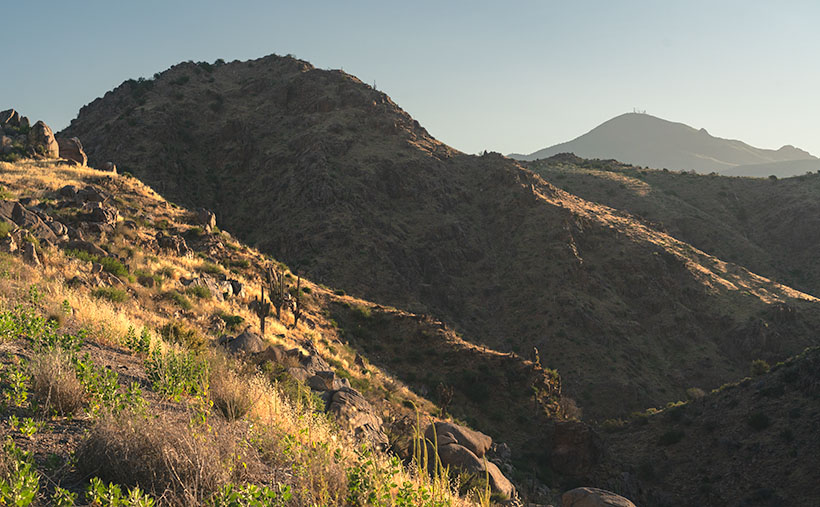
The Mazatzal Mountains, with their rugged beauty, hold within their rocky layers a fascinating geological history that spans millions of years. Formed through intense tectonic activity and volcanic eruptions, these ancient mountains have witnessed the collision of ancient island arcs with the North American continent, creating a massive mountain range. Over time, erosion and subsequent uplift events shaped the Mazatzals into the awe-inspiring landscape we see today. Composed primarily of Precambrian and Paleozoic rock formations, these mountains showcase the power of tectonic forces, as evidenced by their uplifted and tilted nature.

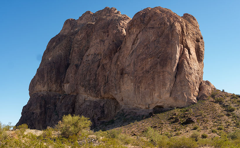
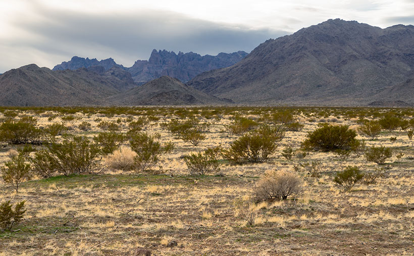
On our imaginary drive through the Mazatzal Range, we reached Rincon Pass near Crabtree Butte. We stopped at this spot to shoot this week’s featured image. East of the Beeline Highway is a 400′ deep canyon carved by Sycamore Creek on its journey to the Verde River at Fort McDowell.

As we stand at the top, soaking in the awe-inspiring beauty of the canyon, the west-facing slopes still lie in shadow while the rising sun casts a warm and enchanting glow on our side. Like interlocking fingers, the ridgelines gracefully descend into the canyon, creating a mesmerizing pattern of diagonal lines. Through the distant haze, our eyes are drawn to Mount Ord, adorned with a majestic crown of communication towers. Rising to an impressive height of 7,128 feet, it proudly claims the title of the highest point in Gila County. Amidst this picturesque scenery, we can’t help but feel a sense of hidden treasure, including the irresistible allure of a rumored swimming hole waiting to be rediscovered.

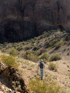
My previous dentist told me that there was a deep swimming hole at this canyon’s bottom. It held cool water throughout the year, where you could soak in complete isolation. He was an avid backpacker, so we took his word for it. I can’t vouch for his story because the creek isn’t visible from the highway. The only way to verify his story was by hiking down to it. As I’ve whined before, I’d need a personal riding drone—but I’ve grown older since then, and today, I’m looking for a flying walker.

Close-up of a desert bush adorned with delicate white flowers in Arizona.
Weeds or Wildflowers? – Witness the delicate beauty of native Arizona flowers as a desert bush showcases its intricate white floral clusters.

As we conclude our stop at the top of Rincon Pass, we find ourselves halfway to Payson, but our adventure through the breathtaking Mazatzals is far from over. The beauty and allure of these mountains extend beyond the Beeline Highway, waiting to be discovered on either side. If you’d like to experience a larger version of Mountains, Canyons, and Sycamore Creek, click on this link (Web Version) to visit the web page or this link (FAA Version) to view my upload on Fine Art America. Join us again next week as we take a refreshing detour along the enchanting Sycamore Creek.

Till next time
Jw

Technique: Setting an image’s black point and white point

Ansel Adams was the master photographer that influenced my work the most. Setting aside his spectacular subject matter and sense of composition, I’m awed by the full range of tones he got in his prints. If you’ve never seen one in person, you’re missing out—the reproductions in magazines and books are different. It’s the equivalent of listening to your favorite music on a cheap transistor radio instead of a live performance. The tune is recognizable, but the song’s not right without the deep bass and sparkling trebles.

Throughout his long career, Ansel worked with a technique called the Zone System. In those days, black and white photo paper could only reproduce ten distinctive shades of gray from the blackest black (zone 0) to paper white (zone 10). His experience meant that he could look at a scene and visualize how it should look on paper. He got his desired results using different exposures, developers, papers, and toning. I tried to learn the Zone System, but I’ll never be that meticulous.

Fortunately for those like me, digital photography has made it easier to master getting full-range photographs, and the PhotoShop tool I use is Levels (all photo editing software have a variation of this tool). After cropping and color balance, my workflow’s third step is setting the black and white points. So I can go back and tweak it later; I always work with adjustment layers.

A screen shot of PhotoShop's Levels Tool.
PhotoShop’s Levels Tool – This handy tool makes setting the black and white points in photographs easy.

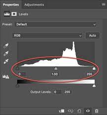
You can make several modifications with the Levels Tool, but I’m a simpleton, so I use the default settings and only make these small changes. Within the tool, a histogram (graph) sits on a baseline and three sliding arrows beneath it. Under the arrows are three boxes with value numbers tied to the sliders. If you move the arrow, the numbers change; if you change the number, the slider moves.

To set the black point, I move the left arrow to the right until it aligns with the graph’s left value. The right arrow will affect the white point, so move it to the left until it’s under the graph’s right end. If the histogram goes from wall to wall, the points are already good, don’t mess with them. I’ve done this process so often that I can usually type in the needed values. The final setting I make with the Levels Tool is setting the midpoint. Its default setting is 1. If my image is for the internet, I set the midpoint (gamma among the in-crowd) to .90 by shifting the center arrow to the right. If I’m making a paper print, I need to lighten it, so I move the center arrow left to set the value to 1.10 (the difference is that the first is a translucent light source, and the second is a reflective light source). After you’ve made your adjustments, you can click on the eyeball icon to turn the layer on and off to see the effect. Your picture will look livelier with rich blacks and sparkly whites.

Have I thoroughly confused you? Well, good. To help you, I found a YouTube tutorial explaining the levels tool (YouTube Levels Tutorial). You can ignore all the other gibberish in this video, but pay attention to his explanation of Adjustments vs. Adjustment Layers and what happens when he moves the sliders. After you watch the clip, you can return here and reread this section—it will make much more sense then.

Courthouse Rock Picture of the Week

Courthouse Rock - The huge granite monolith that attracts climbers and base-jumpers to the Eagletail Wilderness Area.
Courthouse Rock – The massive granite monolith attracts climbers and base-jumpers to the Eagletail Wilderness Area.

When you were in school, did you learn about the Lewis and Clark expedition—the party that explored the Louisiana Purchase and discovered the first Starbucks in what’s now called Seattle? Sadly, when it comes to the outdoors, my buddy Fred and I will never rise to that level of notoriety. We’ll most likely go down in history more akin to Laurel and Hardy.

Fred and Jim's overlapping skill sets - When we get together, things don't always go as we plan.
Fred and Jim’s overlapping skill sets – Things don’t always go as we plan when we get together.

Don’t get me wrong, Fred is a brilliant man. After all, he is an engineer, and I can write complete sentences, so when apart, we can navigate the world and safely return home (to the amazement of our wives). But when we go out together, our skill sets overlap like in a Venn diagram, setting up a thinking interference pattern that causes things to go south.

To finish up this month’s project, the Eagletail Mountains, I needed a couple more photos that are close to the subject. Since it’s a wilderness area, that meant hiking. I spent time researching and found a perfect trail on AllTrails. It’s only 3 1/2  miles each way and goes to Indian Springs. There, we should see a spring and a rock wall of petroglyphs. They described the hike as “the easiest trail in the world. It’s an old mine road with little grade change. A baby can do it.”

I began calculating. I walk at 2.2 miles per hour (I measured it using my hand-held Garmin), so 2 hours in, snap a couple of shots, 2 hours out, and add four hours of drive time down and back. The outing should easily take an afternoon. I asked Fred if he would be interested (somebody needed to carry me out when I fell). He said, “Sure.”

Monday at noon, I tossed on some comfortable jeans, my whitest Tee shirt (so the rescue helicopter could spot me), and a baseball cap. I drove to Fred’s house to pick him up. He opened the front door dressed like an L.L. Bean model, with a freshly pressed ‘cool-shirt,’ safari hat, day pack, and walking sticks. He was gorgeous.

It was a beautiful day, and we spent the two-hour drive talking about the hike and sharing the maps we brought. Fred downloaded the AllTrails map onto his iPhone; I had printed the directions to the trailhead; we were ready.

Mistake #1: The easy part was getting to the Gas-Pipeline road, but we had to count the miles to the turnoff. As Fred read the instructions, I watched the odometer. When the instructions said, “At 1 ½ mile, turn onto an unmarked road,” a road appeared on the left. We turned, but the sign that they promised wasn’t there. We continued anyway and came upon a group of young men camped at its end. This place must be our spot, so we parked.

Mistake #2: The boys/men were friendly and were sitting around packing parachutes. If we were in California, I would have expected them to be waxing surfboards. They had come to Courthouse Rock to climb the monolith and then jump off with a parachute—even though the rock wasn’t in danger of crashing. They asked why we had come. They said we were on the wrong road when we told them about the trail. They said we needed to return to the pipeline road and go another mile. Fred and I looked at one another, the maps, and the app. Since the trail was just over the hill, we ignored their directions—like any person holding a man-card should.

Mistake #3: We started hiking cross-country diagonally toward the trail. “Surely, it must be over that low ridge, and we’ll see it from the top,” I told Fred. We hiked to the ridgeline and saw——another hill. We began the long trudge to its top. What we didn’t realize at the time was that we were climbing Courthouse Rock’s talus slope. The rock must have been significantly larger at one time because sharp granite chips covered the ground. They had flaked off the enormous tower, making the footing lose. Falling on them would hurt—a lot.

Fred the trailblazer - Fred hikes to another ridge to see if it's the last of our hike. It wasn't.
Fred the Trailblazer – Fred hikes to another ridge to see if it’s the last of our hike. It wasn’t.

After an hour of hiking uphills and over gullies, we reached a point where we could see the trail. It was on the other side of a deep wash. That meant we could get to it if we could cross the dry creek, but it was still a half-mile away. We only managed to cover less than a mile during the past hour. I was ready to quit but could see yet another ridge on the horizon. I hoped it was the last. Fred volunteered to continue seeing if it was our summit while I sat, drank water, and caught my breath. He confirmed that it wasn’t, so we started back when he returned.

Instead of retracing our steps, we went down into the wash, where we could walk the sandy bottom back to the Jeep in half the time. We had to explain our failure to the base-jumping dudes when we reached the camp. “Yeah, I thought you should drive to the other road,” one of them graciously taunted. Since we were in the area, we did. We found the second road with signs, parking, and an informational kiosk. At least we’ll know should we ever go back, but the two-hour drive home was nearly silent for now.

I shot this week’s picture that I call Courthouse Rock at the beginning of our hike. It’s of the enormous granite monolith from its west side. The 20-foot palo verde tree gives scale, so I’m glad the tree photo-bombed my shot.

Click here to see a larger version of Courthouse Rock on its Web Page. Next week, we’ll finish our Eagletail Mountain visit and move on to another project. Hopefully, somewhere I can drive.

Until next time — jw

Wilderness Dune  Picture of the Week

Although I’m sure that chasing each other around dunes in Mad Max-style is fantastic fun, being an artist and naturalist, I prefer my sand without tire tracks. If only there were an area of the Algodones Dunes like that. Fortunately for me—and you, if you feel the same—there is. It’s across the street in the North Algodones Dunes Wilderness Area. This set-aside area starts at the highway and continues north for another 15 miles to the Salton Sea. The only tracks you’ll find are those of the critters calling this home.

Wilderness Dune - You can explore dunes without tire tracks in the North Algodones Wilderness Area, which is across the street from the Imperial Dunes Recreation Area.
Wilderness Dune – You can explore dunes without tire tracks in the North Algodones Wilderness Area, across the street from the Imperial Dunes Recreation Area.

For four weeks, we’ve been walking with sand-filled shoes, and you’re asking, “Why is all of this here? Aren’t sandy beaches associated with large bodies of water?” Well, you’re right—here’s your gold star.

Here’s an interesting fact about Imperial Valley, much of Coachella Valley, and the Salton Sea—they’re below sea level. When you drive to San Diego on Interstate 8 and pass the Calexico exit—on the south side, there’s a large water tank rising from the lettuce fields with a painted mark indicating sea level. The grade runs downhill from there north to the Salton Sea. This entire basin was once underwater.

“So, was the Salton Sea much larger then?” No, grasshopper. California’s largest lake is not a ‘natural wonder.’ It’s an engineering blunder. The lake is the result of underestimating the Colorado River’s floods, which resulted in irrigation canals breaching their dykes, diverting the river for two years (1905-1907), and sinking the small community of Salton under 52 feet of water. The Sea suffers from decades of farm runoff laced with high fertilizer and salts that killed everything living in it. It’s now a toxic cesspool best viewed from miles away.

What actually happened was that the entire Salton Basin was part of the Sea of Cortez. Over time, the Colorado River Delta dumped enough sediment to bridge the gap between the mainland and a mountain chain off the western shore (today called Baja California). Like how the Mississippi formed Lake Pontchartrain in Louisiana. The historic landlocked body of water is named Lake Cahuilla (don’t confuse it with the Cholula hot sauce, as I did).

After the last Ice Age, Lake Cahuilla (ka-we-a) began to dry because there was not enough runoff to keep it filled. It finally went dry sometime after 1580. We know the lake existed then because the Spanish sailed ships past the delta into the lake. Today researchers have evidence of old shorelines and native archeological sites around them, providing evidence that people lived in the area for centuries. On the lake’s eastern shore was the Algodones Dunes. Geologists believe that the prevailing northeasterly winds carry Salton Basin sand aloft then dumps it at the foot of California’s Chocolate Mountain Range. Aw geez, now that Queen Anne has read this, she wants to go there because she thinks it’s where Willy Wonka lives.

This week’s photo shows a pristine dune I took from the roadside. The bad news is that you can’t stop here for at least two miles on either side of the fee area described in previous posts. So, to get this shot, I could’ve parked far away and hiked back (uphill in both directions) or paid the $35.00 fee. I’m lucky and glad that the Rangers took a day off.

You can see a larger version of Wilderness Dune on its Web Page by clicking here. Next week we’ll have the final Algodones Dunes story, so come back then.

Until next time — jw

Big Horn Tank Picture of the Week

We’re down to the final month of this gawd awful year. For one, I will be happy to get my vaccination and venture back out into the world again—well, right after you get yours, and I see that you don’t get sick and die from it. I’m afraid that it’ll be months before it’s my turn because I’m too young and pretty. So, because it’s a short month, and Queen Anne has abandoned me, we’re going to explore a road that’s both close by but too expansive to cover in one day.

This month’s focus will be on a road, unlike what we’ve covered on this platform before. It’s not even dirt. It’s a road that stretches from Jacksonville, Florida to Santa Monica, California. It’s also the longest possible way to cross Texas. When Anne and I visited Deb and Fred in Austin several years ago, I was dismayed to see a highway sign that said our destination was further off than the two states through which we’d already driven. I’m, of course, talking about Interstate 10.

Calm down, we’re not going to do the whole thing in one month, and I’m not ready for a lifetime commitment (ask Anne). For December, we’re going to point out the landmarks that I enjoy seeing between Phoenix and the Colorado River. Even with that limitation, there are too many to fit into four Sundays. We’re not even heading in a particular direction; we’ll talk about each place as I get to it.

If you’re like me, you loath driving cross country on the Interstates, but they are the most efficient route when your time is limited. I’ve made countless trips between Los Angeles and Phoenix since moving here a half-century ago, and the flat desert always was the worst grind—river, flat, mountain, flat, mountain, flat, town. After I learned some about the mountain ranges, it was more enjoyable to know that Courthouse Rock was coming up on the south side or that I could spot the abandoned solar observatory on top of Harquahala Mountain. It was like saying, “Hi” to old friends as we passed.

This week’s featured image was taken in the Tonopah area. From east to west, you’ll pass the Palo Verde Nuclear Generating Station, stop at Tonopah Joe’s for gas and heartburn, then on the north side of the highway—where Salome Road crosses—there’s a prominent horn mountain, called Big Horn Mountain. It’s the centerpiece of a wilderness area that’s the same name. Actually, there are two wilderness areas separated by a dirt road that I’ve yet to discover. These are the Big Horn Mountains Wilderness and the Hummingbird Springs Wilderness across the street. You can do backflips across the road from one to the other.

On the plains south of Big Horn Mountain Wilderness Area, is a rusty tank meant to provide water to cattle on the open range.
Big Horn Tank – On the plains south of Big Horn Mountain Wilderness Area is a rusty tank meant to provide water to cattle on the open range.

This week’s featured image that I called Big Horn Tank was taken from the Harquahala Plain off of the Salome Road. There on the open range, I found a rusty water tank for an interesting foreground. I think that rust is a photographer’s favorite color, and I like how the white PVC pipe accents the tank. The other thing I see is how little vegetation cattle have for grazing. They don’t eat creosote (would you), so they only munch on the yellow grass.

You can see a larger version of Big Horn Tank on its Web Page by clicking here. Be sure to come back next week for another roadside landmark from Interstate 10. Tomorrow, I have to phone the Queen to see where I’m allowed to go. Wait till I tell her what happened to me as I was leaving Algodones yesterday—she’ll never let me out of the house again.

Until next time — jw

Mount Tipton Wilderness Picture of the Week

Since our trip to Pearce Ferry, I’ve written about the Grand Wash Cliffs, and rightly so. Last week, I mentioned that they formed the western edge of the Colorado Plateau and that the great river bisects the cliffs. But the Hualapai Valley has another mountain range on its west flank, and they’re the Cerbat Mountains. They fill the 23 miles between Kingman and Dolan Springs. On the drive to Las Vegas on US 93, they’re to the east side of the highway as you travel north through the Detrital Valley.

There are some old mines located in the Cerbats; Cerbat, Mineral Park, and Chloride. Traveling north from Kingman, you first pass the ghost town of Cerbat, which is hidden at the end of a challenging (4wd) road. The next is Mineral Park, which is due east of Santa Clause (that’s another story unto itself). Finally, the biggest one is Chloride—whose tailings are visible from Highway 93. I think Chloride is still active, but I don’t know for what they’re digging.

Mt. Tipton Wilderness Area - The jagged peaks in the Mt. Tipton Wilderness Area are at the north end of the Cerbat Mountain Range.
Mt. Tipton Wilderness Area – The jagged peaks in the Mt. Tipton Wilderness Area is at the north end of the Cerbat Mountain Range.

More interesting to me is the Mount Tipton Wilderness Area, which is almost at the northern end of the Cerbat Range. At 7148 Mt. Tipton is the tallest peak, but the wilderness area also has some jagged peaks that made me stop to take this week’s featured image—even though the sun had gone behind the looming storm clouds. I named the photo Mt. Tipton Wilderness, and it shows dried grasses and creosote bush against the barren granite mountains.

On the whole, I enjoyed our drive to Pearce Ferry. There were a lot of beautiful sights found there, and I can see returning in the future to do more serious photography. That’s the downside of these trips. They’re to photography what Cliff Notes are to books. To get the best results, you need to study and understand the subject.

On the other hand, we’ve only begun to explore Arizona’s back roads, and there’s so much more to see. I feel like I wasted the first two-thirds of my adulthood working for a paycheck. However, I understand that I wouldn’t be here if I hadn’t. I hope I have enough time to finish it all.

You can see a larger version of Mt. Tipton Wilderness on its Web Page by clicking here. I hope you enjoy seeing it. Next week I have a surprise for you. Something completely different, so I hope we’ll see you then.

Until next time — jw

Big Hell’s Gate Picture of the Week

Castle Hot Springs Road’s loop north of Arizona State Route 74 passes three small desert mountain ranges. Driving the road from west to east, first, we skirt the Wickenburg Range, which you can see out of the driver-side window. Shortly after that, the highway began to weave through the Buckhorn Range and past the picture stops, about which I wrote the last two weeks. Just around the bend from the AD Wash Gap, our back road climbs a sharp grade to a ridgeline—the highest point along our journey. There are great views once we reach the top, so a photography stop is imperative.

It was hard to decide where to look when I got out of the truck because there was so much to see. To the north are Castle Creek Basin, Sheep Mountains, and the Bradshaw’s on the distant horizon. This was the only image I took and brought home on my first visit. Of course, I shot with film then and was stingy about wasting it.

View From The Ridge–you can see the Sheep and Bradshaw Mountains in the north from the high point along the Castle Hot Springs Road.

If you turn around and face south, however, you have a great view of Hells Canyon Wilderness and our third range of mountains—the Hieroglyphic Mountains. The Castle Hot Springs Road encircles the wilderness and even passes through a corner along its eastern flank. From this viewpoint, you can see into it and feel like you could reach out and touch it; you can’t get there from here (thanks again, Yogi). Because the wilderness area abuts private property on its north and east sides, you have to hike in on trails from the south or west. Here, there are signs clearly stating, “No Trespassing. No Hunting. No Hiking. Don’t even think about it.”

Big Hell's Gate--An excelent view into the Hell's Canyon Wilderness area with Big Hell's Gate in front of Hellgate Mountain.
Big Hell’s Gate–An excellent view into the Hell’s Canyon Wilderness area with Big Hell’s Gate posing in front of Hellgate Mountain.

I took this week’s picture from this ridge, about halfway back down the hill, to avoid telephone lines. There are several 3000′ peaks in Hells Canyon Wilderness, Governor’s Peak, Garfias Mountain, and the one seen here—Hellgate Mountain. They surround a Burro Flat basin that provides solitude isolated from metropolitan Phoenix.

The gap in the basalt ridge is Big Hell’s Gate, which is the same Bitter Creek ground away we drove through two weeks ago. The creek flows through the gap, then off to the left, gouging another slot called Little Hells Gate. I’ve not been fortunate enough to have seen or photographed it, but maybe someday. As they say in car racing, “As long as there’s movement, there’s hope.

Click here to see a larger version of Big Hells Gate on its Web Page. Be sure to return next week when we see another beautiful stop I made on my Castle Hot Spring Road outing.

Until next time — jw