As you all know by now, Queen Anne and I spent August last year so that I could photograph along Utah’s State Route 12 (wrote a book about it—wan’ a see it—here goes). What you didn’t know is that one morning we drive to Torrey for lunch, and we filmed a time-lapse video with a GoPro stuck to Archie’s roof. It took a while, but I finally assembled all the clips into a 14-minute video that I posted on YouTube this morning.
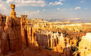
Thor’s Hammer And Sunset Point – Bryce Canyon is the reason most visitors ever drive SR 12, but the video shows what to see before and after Bryce Canyon.
The video shows all of SR12’s 122 miles, and I spliced in spots along the route that are waiting for you to see and photograph. Queen Anne stars in her YouTube debut that will most likely break the Internet. Finally let me say that although it looks like a mad man was driving, I can assure you that the cruise control was set to the speed limit—of course, that may not absolve me from being a crazy person.
You can see Utah’s State Route 12 on YouTube by clicking here. I hope you enjoy watching it and please share your comments or at least give it a thumb up or thumb down.
Utah SR 12 Magazine-84 pages of color photos and stories printed on premium paper and you can buy on its Blurb Page.
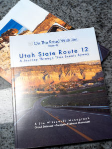
There’s exciting news this morning coming from the international headquarters of Jim Witkowski Photography, located in beautiful downtown Congress. You may have wondered why things have been quiet around here for the last six months, or that I didn’t post many photos from our Utah trip last summer. Well, I was busy using that time to compile years of photographs into my new 84-page magazine—Utah State Route 12, and I’m pleased to announce that it’s ready for début.
The project’s theme is about the beautiful places in the Escalante Grand Staircase National Monument. The monument is so vast that it has three management areas: the western Grand Staircase Region, Kaiparowits Region, and Escalante Canyon Region on the east flank. There is only one paved highway that spans them all—Utah’s State Route 12. In this project, I wanted to show that there are beautiful marvels to see along its length, and the road is more than just a gateway to Bryce Canyon.
I plan to release my work in four versions: PDF, Magazine, Book, and eBook. I have completed the first two, which—I believe—should get the most attention, and I’m still working on the second half. It looks like they will be ready by Valentines. (Are you in the dog house and need a gift?)
PDF—this version is best for viewing on your computer, and except for bandwidth, it’s free. It’s ideal for those of you that don’t need more clutter. You can open the file and begin browsing right away or save it to your hard drive for later.
Magazine—this is a 84-page hard copy of photos and text printed on premium stock paper. I’m delighted with how well the images reproduced. The magazine’s cost is $ 22.99 (plus shipping) is admittedly pricy for a periodical, but compared to the book, it’s a bargain. Blurb handles the sales on their secure Website because they print them to demand. That means that there won’t be surplus versions lining birdcage bottoms.
Book—the large (13 x 11) coffee table book is still in progress which sounds simple, but it’s in landscape orientation, so the layouts have to be adjusted. The photos are larger than the magazine’s, and I had more space to embellish the stories. It will be available in softcover, hardback image wrap, and hardback with dust jacket. The price of the book is expected to be under $ 200.00 at most, so I think there will only ever be one edition—my own if Her Highness lets me.
EBook—this will be the last version and will be easy to do because it’s the book reformatted to fit your Kindle. That’s all handled by the computers. I don’t know what it will cost, but it will be ready next month, so keep watching my Books sections. The downside is that with this version, you won’t get the privilege of collecting dust with it.
I’m planning on releasing a new project each year as Queen Anne, and I travel. For this first project, I had to learn the software and build the templates; something that took up development time. Future projects should go from camera to print quicker. Plans for next year’s project are in progress.
You can get your free PDF version and preview the magazine by visiting their Web Page by clicking here. I hope you enjoy viewing them and please leave your comments here and/or on their Blurb page.
There’s a place on US 89 about halfway between Page, Arizona and Kanab, Utah where the road gets lost. As you know, odd-numbered routes run north-south, but this section of 89 goes east-west for 60 miles between the two towns and right in the middle the road hits all the compass points. There’s a perfectly logical reason they built the road this way. This is where US 89 cuts through the southern part of the Grand Staircase Escalante National Monument, and with three cliff tiers in front of you, it’s just easier to go around them.
The explanation for the five-mile section of looping road is the same. This is when the highway crosses a rift valley and climbs around to the north side of Buckskin Mountain. This is also the spot on the map that is a landscape photographer’s Mecca. You have probably seen photos of exotic geological features and wondered where they were taken. Places like The Wave, White Outcrops, Paria Canyon, Buckskin Canyon, Calico Mountain, and The Toadstools are all within fifteen miles from the road. The bad part of that—for us geezers—is that you must hike that distance to get to them.
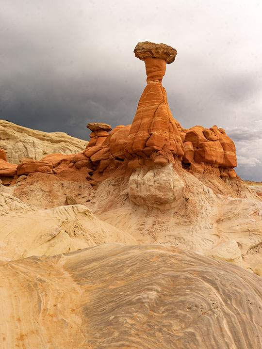
This week’s featured image only required a jone-mile hike, but it involved a climb to a shelf 300 feet above the road. Once you make it, you’ll find a group of toadstools—columns of sandstone supporting a protective capstone. Although the trail up there isn’t flat, you don’t need to be an élite climber to make it. Queen Anne got far enough that she was able to watch her hero snap this photo, which filled her with so much emotion that she had to return to the car and do her nails.
Red Toadstool – A protective capstone is supported by a column of red sandstone near Kanab Utah.
I shot this toadstool from a couple of angles and after viewing the test strips back at camp, I preferred this version even though it’s smaller within the frame. The composition is stronger, and the image is uncluttered, so the formation becomes a stronger subject. The light wasn’t what I envisioned when I planned this trip, but the thunder clouds are kind-of cool. I call this image Red Toadstool and I’m pleased to start a month of Utah photos with it.
You can see a larger version of Red Toadstool on its Web Page by clicking here. I hope you enjoy viewing this week’s post and come back next week when we present another image from a different Utah site.