Lomaki Crater Picture of the Week

Lomaki Crater - When viewed from the far side, Lomaki's tall walls appear like the craters that surround the national monument.
Lomaki Crater – When viewed from the far side, Lomaki’s tall walls appear like the craters surrounding the national monument.

How did your Turkey Day go? I can see your eyes struggling to read these words, so at least you’ve come out of the tryptophan coma and gotten off the couch. That’s good. At least you didn’t turn into that weird uncle that kids are complaining about these days—or did you?

Hassayampa Inn - The four story red-brick hotel was opened in 1927 and is one of the State's historic inns.
Hassayampa Inn – The four-story red-brick hotel was opened in 1927 and is one of the State’s historic inns.

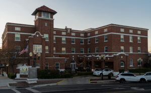
Queen Anne and I skipped our usual Denney’s Thanksgiving Day dinner. Instead, we drove up to Prescott and spent the night at the Hassayampa Inn. Since I’m a history freak, we thought it would be cool to dine at the historic hotel and stay for the night. The red brick hotel is far more charming inside than its block exterior suggests. Art Deco, Spanish Revival, and Territorial styles are all mashed together. Except for the scruffy Romanian bartender, I don’t believe anyone on the staff is over 30. They were so bright-eyed, cheerful, and eager to help that it was depressing.

Dinner—well, lunch, really—was uninspired. The special was a half of a Cornish Game Hen oven-roasted turkey style on a plate with a round lump of stuffing, another lump of mashed potatoes, and green beans. My favorite part of Thanksgiving dinner is gravy. Everything else on the plate supports the gravy, so we had to ask for more on the side. For dessert, the chef managed to duplicate a childhood recipe. My first bite of his apple pie brought a flood of memories of eating a Hostess fruit pie at the Circle K. The biggest sin of dinner was the omission of cranberry sauce molded in the shape of a can. An order of Buffalo wings would have been more satisfying.

With that aside, we had a great time in Prescott. We drank wine beside the lobby fireplace, snuck into room 426—where Faith, the ghost lives, walked around the town square, and ended the night by closing a karaoke bar. It’s not what you think; we literally got the bar shut down. We were in the middle of our version of I Got You Babe, when the health inspector bust through the door. He was there because of multiple complaints of howling dogs as far as three miles away. “That singing is not fit for human consumption,” he yelled to the bouncer. Then he took our mikes and told us to return to the hotel and stay in our room. He then padlocked the place until they got more safety training. I was devastated because Anne does a great Sonny Bono when she gets near the right key.

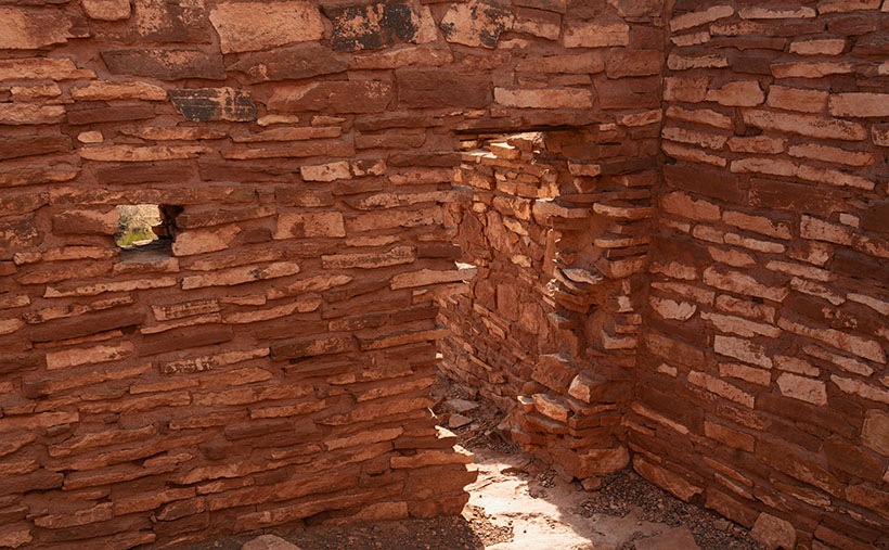
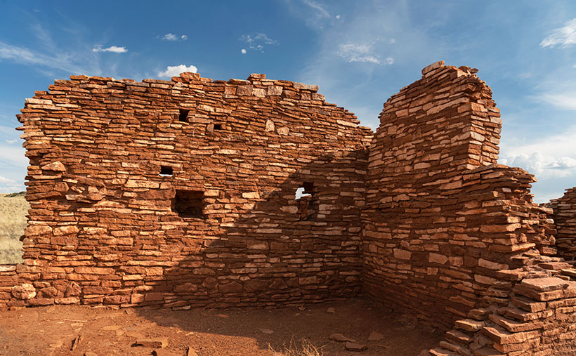
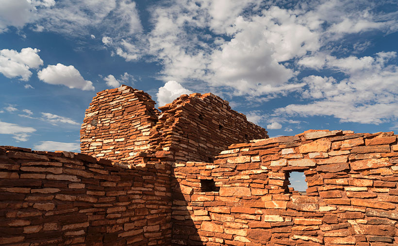
Enough of that; let’s talk about what you came for; this week’s picture. I call the image Lomaki Crater; it’s the last in our series from Wupatki National Monument. I took it on the far side of the pueblo ruin photo from a couple of weeks ago. With a bit of imagination, the tall wall corner resembles a crater like the ones we shot on our visit. There’s even a puff of smoke coming out of the cauldron. The bare walls are a mix of local limestone and Coconino sandstone. When they were built around 1100, they were most likely covered with plaster like the ruins in Walnut Canyon.

You can see a larger version of Lomaki Crater on its Webpage by clicking here. Next week, we start our final project of the year, and even I don’t know what it will be. So, when you come back next week, we’ll both be surprised at what I come up with. I’ll see you then.

Till next time
Jw

BTW:

No dogs were hurt in the making of this article, just my feelings.

Ancient Door Picture of the Week

Ancient Door - A mysterious door between Lomaki rooms beckons you to see what's on the other side.
Ancient Door – A mysterious door between Lomaki rooms beckons you to see what’s on the other side.

When I photograph a place like Lomaki (the Hopi word meaning Beautiful House), I try to walk its perimeter, looking at how the light falls on it. Then I look at details that help fill in its story. As I move around, I’ll stop and take shots of things that intrigue me. My photos are more intuitive than systematic. I look for contrasts and shadow patterns that place the subject in a specific moment.

I was doing that when I entered the Lomaki ruin and came across the door in this week’s picture. I saw the door and thought, “This looks interesting.” I framed the shot and snapped the shutter. Typically, an image with a busy pattern in a uniform light doesn’t work because it looks like a Where’s-Waldo puzzle. However, the dagger of light on the room floor commands your eye to go through the opening. It’s a walk-towards-the-light moment.

As a younger man, I was six-foot tall, but gravity has taken its toll, and now my diminished stature is only 5 foot 11½ inches. Even in my current dwarf state, I had to do a full Asian bow to fit through the doorway. That means that the Pueblo people that built this structure were short. Otherwise, they would constantly bang their heads on the lentil when they came home Saturday nights drunk from the bar. Believe me, that gets old fast.

As I walked through the complex, I got to another room with a low window. Through it, I saw a creature with five legs. It gave me a fright. Was it a centaur with an extra appendage or a giant arachnid with three legs missing? On closer inspection, I saw three legs were carbon fiber, and the other pair wore shorts. The creature turned out to be a fellow photographer. She was a coed from ASU working on a YouTube video about Wupatki.

It’s funny how photographers behave when they bump into one another out in the field. After seeing another camera, they let down any guards. They stop being solitary wanderers and suddenly become highly social as they compare notes. “Did you see this?” You should go there.” In the age of digital photography, it’s gotten worse because now they can compare their shots on the back of their cameras and go into full chimpanzee mode, “Look at this one—ooh ooh ooh ah.”

After our pleasantry exchanges, we parted ways, and she returned to the parking lot. Of course, I didn’t ask for her name or YouTube channel. Queen Anne would kill me on the spot if she knew I talked to a college-aged woman in the field without her chaperoning. After I finished shooting, I hiked back to the parking lot, where Her Majesty was waiting in the car. If I was lucky, her nose was buried in her Kindle reader, and she didn’t notice anything. Before I could say a thing, she blurted out, “I asked that girl if I had to go rescue you.”

“What did she say?”

“She said you were happily wandering around snapping pictures, and you’d be there until you ran out of film.”

It was only then that I realized I was a bit hot, so I started the Jeep and guzzled some water in the cool air conditioning before driving back to Flagstaff. So far, there are no new YouTube Wupatki videos, but I’ll keep looking while I dream of mermaids.

You can see a larger version of Ancient Door on its Webpage by clicking here. Next week, I’ll show my last shot from Lomaki, so be sure to come back and see what we find.

Till next time
Jw

BTW:

It’s Thanksgiving week, so Queen Anne and I wish you a happy and safe turkey day.

Lomaki Picuter of the Week

Lomaki - The crooked walls look as if the fierce Northern Arizona winds will blow them over.
Lomaki – The crooked walls look like the fierce Northern Arizona winds will blow them over.

In the half-century that I’ve called Arizona home, I can’t count the times that I’ve traveled thru Flagstaff and then north on Highway U.S. 89. I travel that route to get to the Grand Canyon, Lee’s Ferry, Lake Powell, Monument Valley, Utah, or Colorado. My best guess would be once a year on average. Sometimes I even stop to take pictures along the way.

With that many trips, you’d think I’d pay no mind to the scenery, but that’s not true. There’s always something new. There’s one location that makes my jaw drop, no matter how many times I see it. I’m talking about the view at Sunset Crater Pass I wrote about last month. It’s an in-your-face example of something I learned in a college geography course: mountains affect climate.

The climate on the south side of the San Francisco Peaks is the polar opposite of that on the north. As you travel to Flagstaff from Phoenix, you climb into the pines, and the temperature can drop as much as 30° along the way. As fronts move north from the Gulf in the summer or west from the coast in winter, the mountains wring moisture from the air as it climbs the slopes. After passing over the mountains, the air is dry and picks up pressure on the way down. Dry air heats faster than humid air. The phenomenon creates a rain shadow on the mountain’s leeward side. The next time you travel north of Flagstaff, stop your car at the pass and take a look back—trees. Then turn to the north again—trees kept away.

Now that you know how mountains work, it’s easy to understand why the early Pueblo Tribes living at Wupatki lived in rock dwellings instead of log cabins. Amazingly, the Indians still used timbers to span the walls and hold up a roof. That means they had to drag lumber off the mountains by hand. They built their structures before the Spanish arrived, so they didn’t have horses.

This week we’re looking at one of the bigger pueblos in the National Monument—Lomaki. That’s a Hopi word that translates into English as “Beautiful House.” Anthropologists have partially restored its two-story walls. As you walk through the ruins, you begin to appreciate the ancient people’s masonry skills and tenacity. They must have had to rent scaffolding for walls that size at A-Z Rentals in town. It was either that or standing on one another’s shoulders. You’d do the same thing.

In this week’s picture, titled Lomaki, you get a good idea of the wall height. The windows are at eye level. A peculiar thing you notice in this shot is the walls are leaning. I’m not sure if the scientist put that feature in on purpose or if they weren’t as skilled as the original Pueblo builders. As a photographer, I have a thing about lines that aren’t level or square. Oceans don’t run downhill, so I wince whenever I see a seascape with a crooked horizon. On my first visit to Lomaki decades ago, its tilted walls jumped out at me. They look like a good wind will blow them over—and this area of Arizona is exceptionally windy. However, on this year’s visit, the walls were still standing and didn’t seem any worse, so maybe they’ll remain long after I’ve gone.

You can see a larger version of Lomaki on its Webpage by clicking here. Next week, we’ll walk around Lomaki and see its details. Come back then and see what we find.

Till next time
Jw

BTW:

The calendar cut-off day is Tuesday, so if you are interested, place your order.

Walnut Creek Bend Picture of the Week

Walnut Creek Bend - It's perplexing to understand how a normally dry creek could carve a deep gorge into the surrounding limestone.
Walnut Creek Bend – It’s perplexing how a usually dry creek could carve a deep gorge into the surrounding limestone.

We had to break from the heat last month, so we drug the trailer up to Flagstaff. We didn’t escape the humidity, though. Since it’s the height of the monsoon season, the weather in the high country was the same as at home—only 30°cooler. There’s been a lot of news earlier this summer about the Flagstaff fires, so we found an RV park on the west side of town—right where Old Route 66 merges with Interstate 40. When we got there, the seasonal rains had already quenched the burn. U.S. 89, which both fires crossed, had reopened, but Sunset Crater National Monument is still closed. It suffered extensive damage to the campgrounds and buildings (otherwise, the cinder cone and Bonita Lava Flow were unharmed).

Our trip served a couple of purposes. First, I needed topics to get this publication through the balance of the hot summer months. Second, we wanted to take Ritz (our trailer) on a shakedown cruise to see how well it and the Jeep played together. Finally, we longed to sleep under the covers with open windows in air, not contaminated with that old-person smell—we accomplished all of that. It’s hard to describe how wonderful it felt to enjoy a glass of wine outside and listen to the sound of rain on the awning. Besides, there’s no more fabulous evening entertainment than watching a newbie learn how to do their first black-tank dump (go back and watch the 2006 movie RV again).

This month’s project is one of the excursions we made to a place that neither Queen Anne nor I have ever been to—Walnut Canyon National Monument. I’m not sure why we missed it. It’s only a couple of miles south of I-40 on Flagstaff’s east side. As you drive the road south, it transitions from Ponderosa Pine to Juniper, so the elevation is lower than the town. The monument is primarily known for the Sinagua cliff dwellings—which I’ll discuss in the upcoming weeks, but it’s the creek we’re interested in today.

On the Colorado Plateau, water generally flows to the Colorado River. In Flagstaff, however, someone put our state’s tallest mountain in the way, so water has to drain around the San Francisco Peaks. A couple of miles west of town, you cross the Flag Divide, where streams flow west of the mountains. East of the divide is the Rio Flag and Walnut Creek Drainage system. Here the streams flow east of the volcanoes into the Little Colorado River. Walnut Creek drains Mormon Lake, Upper Lake Mary, and Lower Lake Mary. You can count Arizona’s natural lakes with one hand, and this little creek drains three of them. Perhaps that explains how an ordinarily dry creek could carve a deep channel into the limestone. Of course, all of that happened before our 22-year drought. Today, Mormon Lake is a broad, shallow dry lake with a mud puddle marking its deep spot, and both Mary Lakes are similarly low.

In this week’s picture, we’re standing at a spot that overlooks a horseshoe bend in the creek. I took this photo from the north side of the canyon facing south. In the distance is Mormon Mountain, some 16 miles south. The lake is located on the left flank of the mountain. When the creek is wet, water flows from right to left and empties into Rio Flag several miles downstream. Then the river turns north and flows under I-40 until it reaches the Little Colorado River, about a mile east of the Grand Falls (sometimes called Chocolate Falls).

I hope you enjoy discovering Walnut Canyon and seeing this week’s image. You can view the Web version of Walnut Creek Bend on its page by clicking here. Next week, we’ll hike one of the trails and poke around some ruins displayed in the national monument. I hope you’ll join us.

Till next time
jw

Cochise Head Picture of the Week

Cochise Head - The 8087' high peak in the Chiricahua Mountains that resembles the great Apache Chief, Cochise.
Cochise Head – The 8087 high peak in the Chiricahua Mountains resembles the great Apache Chief, Cochise.

Living with my editor-in-chief has been particularly stressful. Her sisters are coming for a visit this week. She waltzed her beloved Dyson through the house while singing to the bluebirds, bunnies, and butterflies. She stressed her red vacuum so much that she broke it and had to order parts from Ireland. I don’t think she’s well—I caught her washing a window. I’ve become the red-headed step-child. I have to eat on the back porch, I can’t use either bathroom, and my office desk is the only place I can sit. When I gave her this post to check, I had to check my hand for missing fingers. Cyndi thinks that if she passes this inspection, her sisters will let her accompany them to the palace ball. She’s forgotten that she already hooked her Prince Charming thirty-four years ago. I blame it on this sudden Bridgerton obsession.

Other than that, welcome to May. This month, we will feature images I took as we drove between Willcox and the Chiricahua National Monument. The satin ribbon that ties the collection together is Cochise County Road 186. Otherwise, it’s a collection of odds and ends that didn’t fit inside the park. Over the next five Sundays, we’ll work our way from the monument and back to town. That way, there’s some logic to my presentation.

Right from the beginning, I’m going to cheat. You can’t see the peak in this week’s picture from the highway, and it’s not inside the park, but you can see it best from there. This image is of the 8087′ high Cochise Head in the Chiricahua Mountains’ northern section. For perspective, the eroded granite head is a mile wide. The name is descriptive because it resembles Cochise, the great Apache chief, with his distinctive Mayan nose and a pine tree eyelash. Like Camelback Mountain, no person is credited for the name; everybody just agreed on the resemblance. Imagine having a mountain named for you while you were alive. Arizona has 15 counties, with 12 of them having tribal names. Cochise County is the only one named after a tribe member. I think that shows how much respect our community had for Cochise (of the other two counties, our legislature named one for a mountain (Graham) and the other for a prominent mine owner (Greenly).

When I shot this week’s picture, I tried different compositions that I call Cochise Head naturally. The one that I chose is centered, which is unusual for me. The others seemed unbalanced somehow. As you move up and down the road, the eye and forehead become more or less prominent. I took this shot from my closest position—standing on a rocky ledge overlooking Bonita Creek Canyon.

Click here to see a larger version of Cochise Head on its website. Next week, we’ll make our way back to town for dinner, but there’s a place we have to stop so I can grab another photo. Come back next week and see what I found.

Till Next Time

jw

The Grotto Picture of the Week

Grotto Interior - From the outside, the Grotto looks like a secluded place to hide from the world.
Grotto Interior – The Grotto looks like a secluded place to hide.

Over the past couple of weeks, we’ve been hiking and photographing the Grotto Trail in the Chiricahua National Monument. I know that seems like a long time for a one-mile trail, but I’m old and quickly fall. As you’ve seen in previous photos, massive rock formations that sometimes resemble sculptures line the track. That’s another reason the hike takes me so long—I can’t pass up these shots.

As I walked through the towering erosion formations, I wondered how the grotto would look. By definition, they’re a ‘picturesque cave,’ so I wasn’t sure what I was looking for. I shouldn’t have worried because, as that old proverb goes, “You’ll know it when you see it.” That’s precisely what happened. When I first peeked through a side window, I shouted, “Eureka, I’ve found it.”

It’s a cool room with light filtering in from outside. Four pillars line the room and hold up a slab of stone that fell on top. If you aren’t my size, you can crawl up inside and take a nap or play tea-time should you happen to bring your Barbie set. Because it’s open to the sky, you wouldn’t be able to take shelter from a storm like you’d be able to do in an actual cave.

Grotto From the Trail - When I looked back at the Grotto from the trail, I could see how it was assembled.
Grotto From the Trail – I could see how it is assembled when I looked back at the Grotto from the trail.

After catching my breath for a minute, I started back to the parking area. I was only a few steps down the road when I turned around and shot this second image. It gives you a better idea of how the Grotto is assembled, and quite frankly, it doesn’t seem to be a secret room—just an interesting pile of rocks. You can see a larger version of The Grotto on its Web Page by clicking here.

Since today is the last Sunday of the month, this is the end of April’s Chiricahua project. I took many more pictures, but I couldn’t show you all of them in only four weeks. If only there were another way for you to see them. Oh wait, there is.

Wrote a book about it—wanna see it?—here it is.

Chiricahua National Monument – My new photo essay of our trip to Cochise County will be available on Amazon, but you get a free preview because you’re a subscriber.


I’ve been working on a book while talking with you to prove that I can walk and chew gum. It’s the second in my sampler photo essay series. This one is called Chiricahua National Monument, and it includes the photos I’ve shown this month, plus a couple dozen more. Chapters in the book cover the Faraway Ranch, the hiking trails, and the landscapes surrounding the park.

It isn’t listed yet, but like my last book—Snow Canyon—it will be sold exclusively on Amazon at a ridiculous price of $68.00—unless you want to order a half-dozen or more, I can get a discount for you. Otherwise, no one will pay that price. But because you’re loyal readers, I devised a way for you to read the book and see my other photos—for free. I ordered a PDF version that you can open and download using this link: Chiricahua National Monument. PDF. You’re welcome to download it, print it, and toss it in the garbage when you’re done. I hope you enjoy it.

Next week is a new month, and we’re not entirely done with Cochise County. I found some pretty things to show you outside of the park, so come back next week when we begin May’s project.

Till Next Time

jw

Tulip Rock Picture of the Week

Tulip Rock - A formation that I passed on the Grotto Trail that looks like a tulip to me.
Tulip Rock – A formation I passed on the Grotto Trail that looks like a tulip to me.

One of my loyal readers commented that she couldn’t see the rock creatures like me. If you’re like her, that’s ok. Maybe your mind isn’t wound up like mine, or you’re not on the same prescriptions. Whatever the difference is, I’m simply trying to show you the world as I see it.

This week, I have another Rorschach test for you. It’s a picture of a second remarkable formation I found while hiking the Grotto Trail. I call it Tulip Rock because I think it looks like a flower. It could be a rosebud, a daisy, or a dew-covered morning poppy. Don’t see it? As long as you don’t see the Prince of Darkness who’s come to cast humanity into eternal damnation, you’re alright. If that were the case, I’d suggest you consider a change of meds.

When I composed this image, I wanted to show a couple of things. The first is that most of the hoodoos in Chiricahua don’t look like sculptures; they’re ordinary. That uniqueness makes the formations like this and last week even more special. I found two examples (there are more) on my short hike on the Grotto Trail. Imagine the images I’d have if I had visited the Chiricahuas as a younger man.

The other thing that I wanted to show is the background. The higher peaks of this range are along the horizon, including the 9700-foot Chiricahua Peak. As you can see in this image taken in late March, they are still snow-covered. They’re part of the Coronado National Forest—sometimes called the Sky Islands. The forest isn’t contiguous—it includes several southeastern ranges separated by broad basins. I’m not aware of another forest like it in the United States. Feel free to correct me if I’m wrong.

You can see a larger version of Tulip Rock on its Web Page by clicking here. Come back next week when we finally make it to the Grotto—a four-pillar room with a rock roof.

Jeff Goggin

It’s painful to type these words. Jeff Goggin—the other half of the Ballast Brothers Racing Team—died Thursday a week ago (7 April 2022). He was the last surviving family member and lived alone in the family’s Scottsdale home. Jeff’s mother lost a long degenerative battle with Lou Gehrig’s disease. It’s still untreatable. Several years ago, he told me that he was starting to show the same symptoms. Being the insanely practical man we knew, he ended his life to spare himself further suffering while he could still make his own decisions. Jeff is survived by his estranged partner, Paula Hoff.

Jeff was a brilliant, caring, funny man who loved good music, sick jokes, fast cars, fine art, a good scotch, and pretty women. Queen Anne and I miss the jerk.

Till Next Time

jw