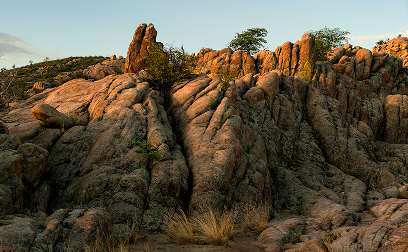
Lomaki Crater Picture of the Week

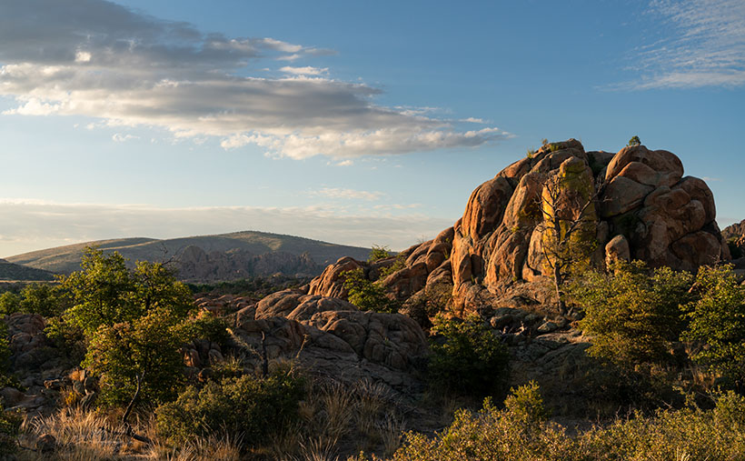
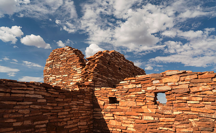
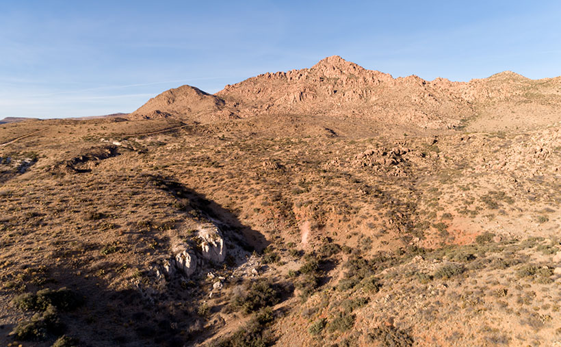
Lomaki Crater - When viewed from the far side, Lomaki's tall walls appear like the craters that surround the national monument.
Lomaki Crater – When viewed from the far side, Lomaki’s tall walls appear like the craters surrounding the national monument.

How did your Turkey Day go? I can see your eyes struggling to read these words, so at least you’ve come out of the tryptophan coma and gotten off the couch. That’s good. At least you didn’t turn into that weird uncle that kids are complaining about these days—or did you?

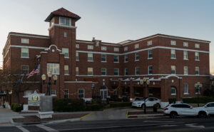
Hassayampa Inn - The four story red-brick hotel was opened in 1927 and is one of the State's historic inns.
Hassayampa Inn – The four-story red-brick hotel was opened in 1927 and is one of the State’s historic inns.

Queen Anne and I skipped our usual Denney’s Thanksgiving Day dinner. Instead, we drove up to Prescott and spent the night at the Hassayampa Inn. Since I’m a history freak, we thought it would be cool to dine at the historic hotel and stay for the night. The red brick hotel is far more charming inside than its block exterior suggests. Art Deco, Spanish Revival, and Territorial styles are all mashed together. Except for the scruffy Romanian bartender, I don’t believe anyone on the staff is over 30. They were so bright-eyed, cheerful, and eager to help that it was depressing.

Dinner—well, lunch, really—was uninspired. The special was a half of a Cornish Game Hen oven-roasted turkey style on a plate with a round lump of stuffing, another lump of mashed potatoes, and green beans. My favorite part of Thanksgiving dinner is gravy. Everything else on the plate supports the gravy, so we had to ask for more on the side. For dessert, the chef managed to duplicate a childhood recipe. My first bite of his apple pie brought a flood of memories of eating a Hostess fruit pie at the Circle K. The biggest sin of dinner was the omission of cranberry sauce molded in the shape of a can. An order of Buffalo wings would have been more satisfying.

With that aside, we had a great time in Prescott. We drank wine beside the lobby fireplace, snuck into room 426—where Faith, the ghost lives, walked around the town square, and ended the night by closing a karaoke bar. It’s not what you think; we literally got the bar shut down. We were in the middle of our version of I Got You Babe, when the health inspector bust through the door. He was there because of multiple complaints of howling dogs as far as three miles away. “That singing is not fit for human consumption,” he yelled to the bouncer. Then he took our mikes and told us to return to the hotel and stay in our room. He then padlocked the place until they got more safety training. I was devastated because Anne does a great Sonny Bono when she gets near the right key.

Enough of that; let’s talk about what you came for; this week’s picture. I call the image Lomaki Crater; it’s the last in our series from Wupatki National Monument. I took it on the far side of the pueblo ruin photo from a couple of weeks ago. With a bit of imagination, the tall wall corner resembles a crater like the ones we shot on our visit. There’s even a puff of smoke coming out of the cauldron. The bare walls are a mix of local limestone and Coconino sandstone. When they were built around 1100, they were most likely covered with plaster like the ruins in Walnut Canyon.

You can see a larger version of Lomaki Crater on its Webpage by clicking here. Next week, we start our final project of the year, and even I don’t know what it will be. So, when you come back next week, we’ll both be surprised at what I come up with. I’ll see you then.

Till next time
Jw

BTW:

No dogs were hurt in the making of this article, just my feelings.

Prescott Basin Picture of the Week

There’s a growing trend in the comedy routines that Queen Anne and I watch on YouTube’s Dry Bar channel. The bits poke fun at young people for not knowing about obsolete things my generation regularly used. I’m not sure if the joke is at the youth’s expense or if it’s simply us old farts complaining about change again.

To give you an example, one performer asked a teen in the audience to explain the relationship between a pencil and a cassette tape (the kid didn’t know what the tape was). Another was about the phone books we used to get each year. The fact that we had to look numbers up on our own was mind-boggling enough, but they couldn’t comprehend that the books were primarily used at grandma’s house as a booster seat. Finally, hold up a 10’ curly phone cord and ask a young person why it existed.

I uncovered another lost phone tradition this week after talking to a particularly annoying salesman. It’s known as the old 40mph-hangup. I learned it from my dad back in the age of unenlightenment. It has Zen-like qualities and resembles a marshal-arts move, but it more closely mimics the grace of a baseball pitch. I’ll try my best to describe it. After you’ve had your fill with the person at the other end of the line, you scream a final taunt—after all, you must have the last word—then as you lift your left leg, you begin to swing your right arm in a full roundhouse motion and slam the handset onto the cradle. It should bounce at least once. I saw my father shatter an old black Bakelite phone we were renting from Ma Bell. Although this hang-up never accomplished anything productive, it always put a satisfying exclamation point on your lunacy.

With remote handsets these days, they took away that small joy of life. No matter how hard you mash the End button, it’s silent. Your adversary doesn’t know if you hung up or the phone dropped the connection. I don’t own a smartphone, but vigorously swiping at the screen can’t be any better. Maybe someone could write an app that plays a recording of a loud car crash before disconnecting. That would come close. Kids don’t know what they’re missing.

Now we have to find another channel to drain all that excess adrenalin. I could have run up and down the Little Granite Mountain Trail a couple of times with that pent-up anger. I wouldn’t have even broken into a sweat by the time I reached upper flats. Instead, I had to stop constantly until the pounding in my ears subsided.

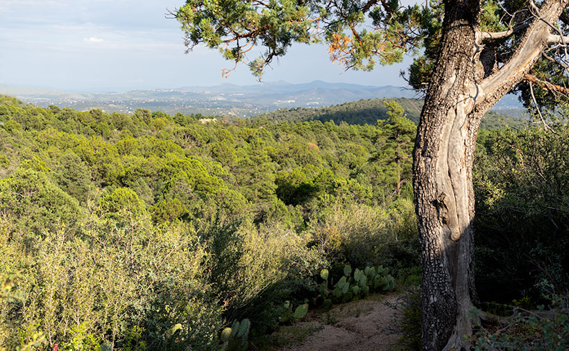
Prescott Basin - You can see miles in any direction from the flats on the Little Granite Mountain Trail, like this view of Prescott to the east.
Prescott Basin – You can see miles in any direction from the flats on the Little Granite Mountain Trail, like this view of Prescott to the east.

It was at one of those rest stops that I got this week’s featured image. Close to the trail’s top, it begins to flatten, and you can finally see above the trees. After I passed this Alligator Juniper, I stopped for a rest. Here, I could see Prescott in the distance below, so I couldn’t resist snapping a photo. The view was hazy from the humidity, so I’m sure it would be spectacular on a clear winter afternoon. I call this photo Prescott Basin. I hope you enjoy seeing it.

You can see a larger version of Prescott Basin on its Web Page by clicking here. Next week, we’ll walk around and take in more views from the top of the trail, so I hope to see you then.

Until next time — jw

Prickly Pear Fruit Picture of the Week

For September, I’m going to bring you something out of the ordinary. We’re going to put the clouds behind us, pull off the road, and get out of the truck. We’re going to go for a short walk down a path—well, it’s more like a hike up a steep trail. I survived, so you’ll be fine. I promise you’ll be fine.

The subject that I originally had in mind for this month was the Sierra Prieta Range. The name is Spanish and means Cold Mountains. They are an offshoot of the Bradshaws. If we went to the top of Prescott’s tallest building and faced west, you’d be looking at the Sierra Prieta. Then if we turned south, the mountains that we stared at would be the Bradshaws. The best-known icons of the Sierra Prieta are Granite Mountain, Little Granite Mountain, and Thumb Butte.

So, when the rains finally broke late this week, I hopped in Archie and drove up to the Little Granite Mountain trailhead. All I intended to do was get above the treetops and photograph some of the mountain peaks. However, the surrounding chaparral was so dense that I wound up where my trail intersects with the Clark Spring Trail—a mile and a half further and four hundred feet higher than I intended. The good news is that I frequently had to stop and rest, and when I did, I was able to shoot some pretty things around me. When I returned to my computer that evening, I changed my month-long project from an entire mountain range to a single trail—well, the first third of it.

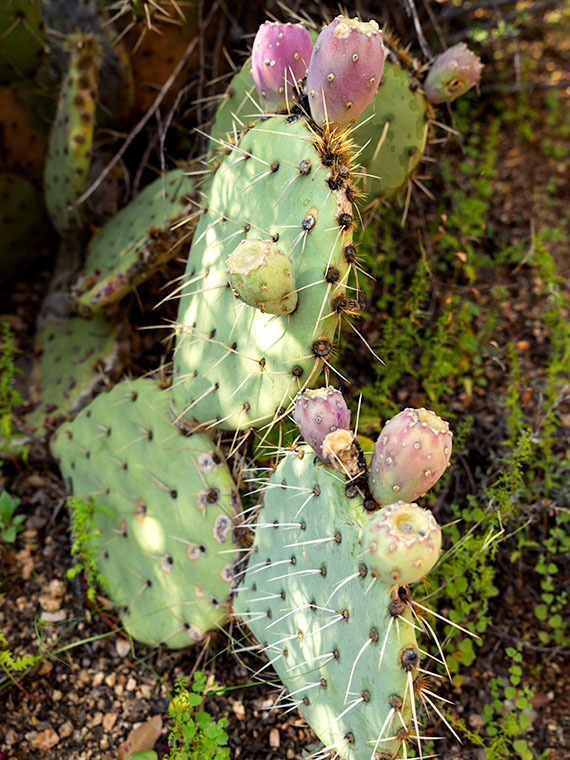
Prickly Pear Fruit - A prickly pear growing in the shade of an alligator juniper in the Sierra Prieta Mountains.
Prickly Pear Fruit – A prickly pear growing in the shade of an alligator juniper in the Sierra Prieta Mountains.

The underbrush along the trail is a transitional zone. It’s where Sonoran Desert plants intermingle with those found in our mountains. This week’s contribution is an example. In the photo that I call Prickly Pear Fruit, a common cactus is growing in the shade of an Alligator Juniper. Y’all should know by now that I’m fond of subjects in dappled light, and that’s what drove me to my knees to get this shot.

I like the soft pastel colors of this plant and the complementary color of its ripening fruit against a background of deeper green ground ferns (or whatever they are). I guess the purple is the prickly pear’s way of saying, “Here, eat this part,” to javelina. They eat it like candy. But, the piggies disperse the seeds in their scat, so both parties benefit from the exchange.

As an aside, the fruit makes a great jam that is getting harder to find. It’s sweet and spicy, and I like that taste combination. Because it’s not widely sold, only local kitchens produce it. Our health inspectors have been shutting down the mom-and-pop shops because they don’t have extensive stainless steel production lines like big food producers. So—like moonshine these days—you have to know someone who knows someone—or roll your own.

You can see a larger version of Prickly Pear Fruit on its Web Page by clicking here. Next week, we’ll take a few more steps up the trail until I’m out of breath again, and you’ll see what I found while I rested.

Until next time — jw

Kirkland Peak Picture of the Week

Our home in Congress is on a scenic byway. Each weekend, there are lines of exotic sports cars and motorcycles that pass by our trailer park to prove it. There are several roads— like AZ 89—in our state that offer motorsports enthusiasts a venue to stretch the legs of their beloved machines. I’m sure that the other states have roads like ours. I’m surprised that someone hasn’t compiled an encyclopedia of “The World’s Great Weekend Roadtrips.”

The route passing our home is known as the back road to Prescott because it avoids the weekend traffic on Interstate 17. It’s a longer drive, but that’s not the point. I think this passion is best described in Queen’s song; I’m in love with my car. “. . . get a grip on my boy-racer roll bar . . .” (Yes Virginia, Queen recorded songs other than Bohemian Rhapsody). It’s customary to play this anthem at full volume with the top down and the sun flickering through the pines on to your Ray-Bans.

There are actually two ways to get to Prescott from here. The first is to stay on ’89 and drive between the Sierra Prieta and Bradshaw Mountains. The motor-heads like this way because they get to test those big Brembo brakes on their Lamborghinis. This way is challenging to keep up with the speed limit, your up in the pines quicker, and the road dumps you onto Whisky Row, where everyone parks around the courthouse for an impromptu car show.

The second option is better if you’re towing a trailer, hauling a load of eggs from Costco, or you’re trying to keep Queen Anne from throwing up in your lap. To go this way, you turn off at Kirkland Junction and pick up Yavapai County Route 10—Iron Springs Road. This route is more docile, as you travel through Kirkland, Skull Valley, and Iron Springs, although it’s a bit trickier to find your way downtown once you get to Prescott.

Kirkland Peak - The run-off from the granite covered mountain has cut into a layer of limestone deposited on an old lake or sea bed.
Kirkland Peak – The run-off from the granite covered mountain has cut into a limestone layer deposited on an old lake or sea bed.

It’s on this second route that you’ll see the subject of this week’s featured image—Kirkland Peak. It will be the rocky mountain filling your windshield at the Kirkland stop sign. There’s even a better view if you drive straight and cross the tracks. But right now, we’re going to turn right onto Iron Springs Road toward Prescott because there’s something else I want you to see.

Soon after leaving the junction, CR 10 follows the railroad tracks and Skull Valley Wash filled with cottonwood trees. In this section—between Kirkland and Skull Valley—there is a cluster of limestone hoodoos where the granite top layer has been eroded. I’ve tried to photograph the outcrops on several occasions, but telephone lines and private property frustrated me. When I visited last week, a new mine has begun setting up operations, and they’ve scraped the land clean. There are two new five-story silos built beside the road, and I’m afraid that the remaining hoodoos will be gone shortly.

When I drove up to shoot Kirkland Peak this week, I was pleased to find a place where the mountain’s run-off has exposed more limestone, as seen in this week’s picture called Kirkland Peak. There are eons of geology exposed in this photo. The bottom layer is an ancient lake or sea bed, covered by granite (lava cooled slowly), and a mountain thrust above them. The evidence of up-thrust is in the grain of its rocks along the ridgeline (you can’t see that on your phone). As Kelly Bundy said, “The mind wobbles.”

You can see a larger version of Kirkland Peak on its Web Page by clicking here. Next week, I’ll bring you another image from our corner of the world.

Until next time — jw

Stamp Mill Picture of the Week

Everyone has heard the axiom, “All roads lead to Rome.” Well, not in Yavapai County, they don’t. Over the past couple of years of traveling Arizona’s back roads, I’ve found that they lead to mines, and with good reason. We all have a vision of a dusty prospector sneaking off with a couple of burros to a secret gold mine in the mountains—this is before he became the Arizona Lottery huckster. A man like Jacob Waltz may discover a vein of gold, but it takes a corporation to extract it effectively.

To make a ton of money, you have to move a thousand tons of ore. A couple of burlap sacks strapped to a burro’s back just won’t do. You have to move unrefined earth by wagon, truck, or railroad car. So part of The Company’s infrastructure is getting things to and from the mine site. That is the Phelps-Dodge and the Senator Mine story—and this month’s back road adventure.

While bouncing along the Senator Highway in R-Chee (according to his license plate that’s the correct spelling), Anne suddenly blurted, “There’s a large building down there.” Since my side wasn’t overlooking the cliff, I couldn’t see it, so I stopped the truck and walked back to see the steel skeleton of an old structure. “Cool,” I told her as I climbed back into the driver’s seat. “It’s too early, so we’ll stop on the way back when the light is better.”

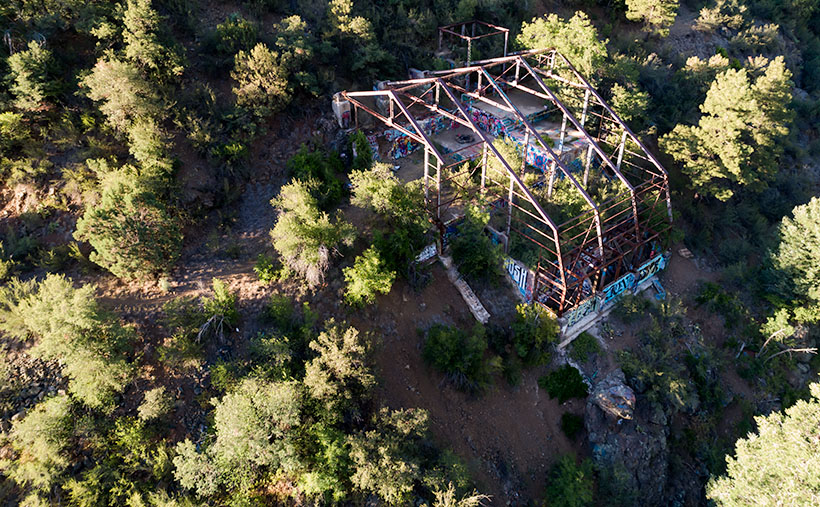
Stamp Mill - The ruins of the Senator mine stamp mill are perched above the headwaters of the Hassayampa River.
Stamp Mill – The ruins of the Senator mine stamp mill perches above the headwaters of the Hassayampa River. The mill is visible on Google Earth if you zoom in to the Senator Highway where it crosses the Hassayampa River.

After some research, I found out that the building was a 10-unit stamp mill for the Senator mines. As rock came from one of the three parallel shafts, the miners hauled it to the mill, where the hammers pounded big boulders into small ones. As far as ghost towns go, we struck gold (I couldn’t resist the pun, sorry). Concrete foundations usually are all we find in these places, but since this frame was a steel and not timber, the skeleton survives and gives scale to its size. From the road, I could easily walk down the stairs and wander the four floors. Vandals have decorated the remaining vertical walls for Christmas with colorful graffiti everywhere, so I guessed that we weren’t the first people to find this place.

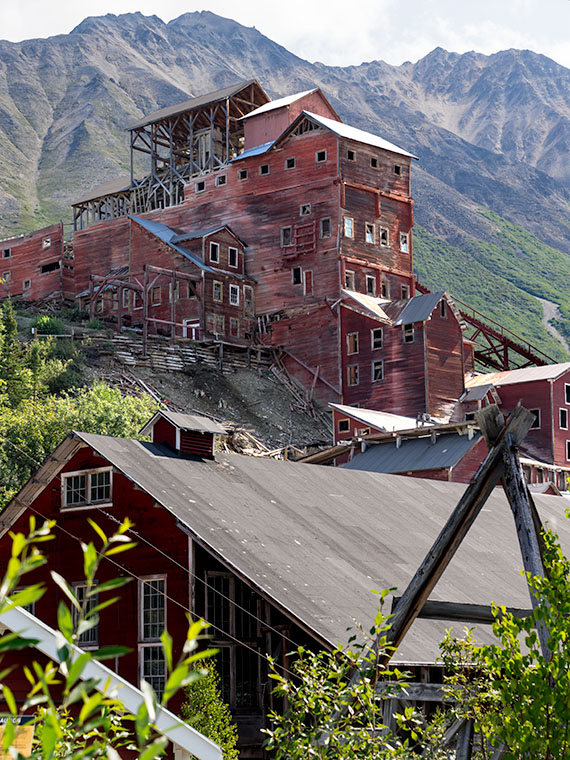
Kennecott Mine - The Kennecott mining town is preserved in the Wrangell-St Elias National Park in Alaska. This should give you an idea of how a mill looked with the clapboard still intact.
Kennecott Mine – The National Park Service has preserved the Kennecott mining in the Wrangell-St Elias National Park in Alaska. This photo should give you an idea of how a mill looked with the clapboard still intact.

In Alaska, I visited a similar mill at the Kennecott Mine in the Wrangell Saint Elias National Park. At this location, the Park Service keeps that building in an arrested state of decay, and it still has the red clapboard siding. I wanted to show you how the Senator stamp mill might have looked while it was running, so I’m including my Alaska photo.

For this week’s featured image—that I call Stamp Mill—I wanted to show the building and its environment, which is hard to do while standing inside of it. So, I took this shot from the far side of the Hassayampa River Canyon as the sun hung low in the western sky. I was lucky in that the remaining silver paint glowed in the afternoon sun, which makes the frame pop from the background.

You can see a larger version of Stamp Mill on its Web Page by clicking here. I hope you like it. Be sure to come back next week when we present the final image from our drive on the Senator Highway.

Until next time — jw

Shadows, Boulders, and Cracks Picture of the Week

Queen Anne and I had only ventured into the Bradshaw’s once before this month’s Senator Highway adventure. We borrowed a friend’s 4wd tow truck and wanted to see how well it performed on dirt roads. We decided to drive to Crown King for Sunday brunch. It was a horrible experience—lunch was nice, but the track was one long washboard. The truck bounced so much that it took a week for our eyes to stop vibrating. That was before Google Maps—actually, it was before computers—so we added another unnecessary 50 miles to the trip. Anne swore off dirt roads forever.

That’s too bad because the Bradshaws (named for trailblazer William D. Bradshaw) fascinated me since I moved to Phoenix. From the valley, they’re the high range to the north. When you head Flagstaff, they’re the first pine-covered mountains that you pass. The Sunset Point rest stop, which is at the range’s eastern flank, is where I feel that we’ve at last got past the city limits. Finally, during the summer monsoons, they create the storms that bring rain to the valley (as I look out my window today, I see what could be our first seasonal storm—and it’s moving south from the Bradshaws—if it gets here at all).

Whenever we’ve stopped at Sunset Point, and I had to wait for you-know-who to finish up in the bathroom, I always looked up at the mountains and mistakenly thought that they were dry and deserted. I’d think to myself, “It’s too bad there aren’t any fishing lakes up there.” On our recent trip, I found out that I was wrong because back roads lace through the range leading to former mining towns filled with summer cabins. There are even a couple of small lakes—but they’re so close to Prescott, I’d classify them as town lakes. Perhaps it’s just as well that there’s no destination up there, because if there were a big lake up there, then there’d be freeways and planned communities around it.

Shadows, Boulders, and Cracks - This is the simplest essence of what I found interesting about a pair of granite boulders south of Groom Creek, Arizona.
Shadows, Boulders, and Cracks – This is the purest essence of what I found interesting about a pair of granite boulders south of Groom Creek, Arizona.

As Anne and I continued exploring Senator Highway, we came across a boulder field south of Groom Creek. I find these large lumps of granite interesting, but they’re all over the state, and my rock collection is vast. I hear people say, “Meh. It’s another rock picture.” So, for this week’s featured image, I tried to show just the part that made me raise the camera to my eye. In the case of this week’s featured image, that I call Shadows, Boulders, and Cracks, it was the texture of the massive rocks, the delicate shadows of the deciduous trees, and the fracture that splits the right sphere in half. Even without seeing the entire boulder, you instinctively know that you couldn’t skip one of these pebbles across Goldwater Lake.

You can see a larger version of Shadows, Boulders, and Cracks on its Web Page by clicking here. I hope you like it. Be sure to come back next week when we present another image from the Senator Highway going south from Prescott.

Until next time — jw

Road Bend Picture of the Week

Although I’ve tried my best to hold back time, the season has changed,  and it’s summer again in the desert. Summer’s dog days are the worst time to be photographing our arid home. Except for the brief respite at either end of the day, the bright sun and ozone combine to wash the colors away. It’s like seeing the world through a 2% milk bottle—the glass ones, not the cartons. You need polarizing sunglasses to force the blue to show in the sky again.

We desert-rats are nothing if not adaptive. Like all of the other Sonoran critters, we hide in our holes during the day. For example, the Round-tailed Ground Squirrel escapes the day heat in his den by sleeping splayed-out on his back. I do the same thing, and I’d show you photographic evidence except I’d be banned forever from the Internet. The other thing we do is migrate. Even during this pandemic, Highway U.S. 93 was a parade of boats heading north towards the rivers and lakes on this holiday weekend.

When we were deciding on a project for July, Queen Anne and I followed a similar logic. We looked for someplace cooler—trust me, 90º is cooler than 110º. We scoured our maps for a place nearby in the mountains, a location that wouldn’t have crowds yet be accessible. We settled on the Senator Highway that runs from Prescott south into the Bradshaw Mountains.

Road Bend - Bright yellow-leaved deciduous trees obscure what's beyond the road on the Senator Highway south of Prescott, Arizona.
Road Bend – Bright yellow-leaved deciduous trees obscure what’s beyond the road on the Senator Highway south of Prescott, Arizona.

Until this month, I didn’t know why there was a dirt road called the Senator Highway. I imagined that it was a route that our state assemblymen traveled when Arizona’s capital swapped several times between Prescott and Phoenix—foolish me. Instead, it’s just another mine road that the miners built it to transport ore and supplies between the Senator Mine and Prescott. If you’re skilled at navigating the Bradshaws, you can technically get to Congress via the Senator Highway.

I find the pine-covered mountains, like the Bradshaw’s, hard to shoot. The trees get in the way. I mean, how many different ways can you get an image of ponderosa pine tree bark? I hunt for edges—splashes of color, an opening to the horizon, or building ruins. That’s what I’m showing in this week’s featured image. At a bend on the highway, I saw some trees (I believe Arizona Ash) with bright yellow-green leaves shinning in the sun against the duller blue-green evergreens. I liked how they obscured the path. My mind wants to find out what’s beyond. It’s a classic leading-line perspective trick, and I find the dappled shade on the road a bonus. I named the first image for our July project Road Bend because it’s a simple title for a simple photo.

You can see a larger version of Road Bend on its Web Page by clicking here. I hope you like it. Be sure to come back next week when we present another image from the Senator Highway outside of Prescott.

Until next time — jw

%d bloggers like this: