Ajo Mountain Picture of the Week

I turned my calendar over this week, and that means a couple of things to me; the best is that it’s the final quarter of 2020. In an average year, the hot weather finally breaks in a couple of weeks, because there’s an Arizona law that prohibits kids from Trick-or-Treating on a hot night. Of course, nothing about this year has been normal, so I’m not holding my breath. The Queen and I are looking forward to opening the house soon, and I’m anxious to take my drone out again and resume filming.

For October’s project, I drove south into the heart of the Sonoran Desert. As I said, we live along the northern edge of the saguaro country. We have a good population here in Congress and Wickenburg, but in other parts of the state, the giant cactus thrives. To show you, I traveled south of Ajo last week and drove the Ajo Mountain Drive loop in the Organ Pipe Cactus National Monument. The road is unpaved, but a sedan will make it as long as it’s not raining.

A couple of years ago, Anne and I visited the monument for the first time. I wanted to take this loop, but we didn’t bring an off-road truck. Plus, when she saw a sign warning of smugglers and illegal aliens, she said no. The park is 10 miles from the Mexican border, and 30 miles south of the old copper mining town of Ajo (evidently the Spanish found wild garlic growing in the area, so that’s how it got the name). The road passes through the middle of the Goldwater Bombing Range, so I’d recommend not stopping along the way to pick wildflowers.

The Monument is the only place where you can see large stands of Organ Pipe Cactus. They’re more common south of the border, but on this side—not so much. The two columnar cacti (saguaro and organ pipe) grow side-by-side throughout the park. With the dry summer that we’ve had this year, I was pleased to see that the specimens in the monument looked healthy and watered. The rain patterns in lower Pima County are different from home, and they had a better monsoon than we did. The cacti are packed in down there—if you could ever call a desert lush, Organ Pipe would be an example.

Ajo Mountain - The volcanic peak rises above its foothills in the Organ Pipe Cactus National Monument.
Ajo Mountain – The volcanic peak rises above its foothills in the Organ Pipe Cactus National Monument.

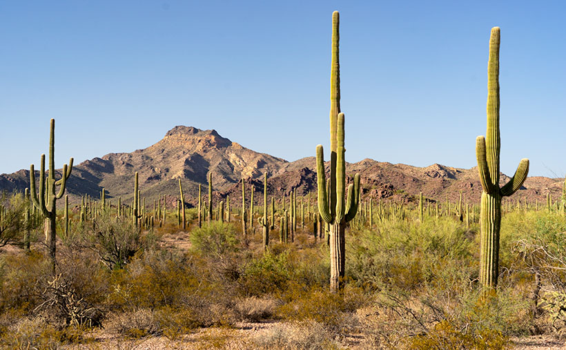
Ajo Mountain is the name of this week’s featured image, and in it, I was trying to show two things. They are the volcanic mountain—rising above its surrounding foothills—and how many saguaros are growing per square mile. These giants also seem significantly taller than our home-boys.

You can see a larger version of Ajo Mountain on its Web Page by clicking here. Next week we’ll stop further along the drive and show you the organ pipe cactus from which the monument gets its name.

Until next time — jw

Ferguson Valley Picture of the Week

Queen Anne—as my mother would frequently say—is deaf in one ear and can’t hear out of the other. However, she can tell the difference between me calling, “Anne” and the blood-curdling scream, “Aaannee.” I know this to be true because it happened this week when she rushed to my rescue.

I was busy watering the potted flowers that live on the back deck. We keep them there in the shade during the summer, and I have them arranged on the back doorstep, so the bunnies don’t get to them. It doesn’t work because one or two rabbits will scamper off whenever I open the door. I used my cute water can instead of dragging the hose to conserve water. As I finished the mums, I stepped to the left toward the geraniums. There between the two pots was a western diamondback rattlesnake lying in a wad like a pile of tan rope. It laid there motionless while I involuntarily took a couple of steps backward while I screamed in a voice a couple of octaves higher than my normal range.

When she came to see what the fuss was about, I could only stutter, “porch … snake.” She stepped outside and sized up the serpent, then went back into the house. She quickly returned with a long stick that she had used to knock down a hornet’s nest on the front porch. She marched over to the rattler—which hadn’t twitched yet—took a stance, and began whacking at it. The vermin’s head popped up like it had been sleeping and tried to escape to the left. Anne was too quick and outflanked it, then she took a couple more swings at it. Then the legless reptile reversed course and slithered across the landing before it escaped down a gap between the decking and the house.

“Now what’ll we do? What happens now?” I pestered while dancing from foot to foot like I had to go to the potty. She leaned her stick against the house and went inside and called the fire department. I stood watch, ready to run away the moment I saw any movement. When she returned, she assured me, “They said to leave it alone. It knows it’s not loved and will move on when it feels safe again. If we see it again, we’ll call them, and they’ll come to remove it for us.” I was still upset, and I whimpered while nervously rocking back and forth. That’s when she slapped me across the cheek and commanded me to “Snap out of it.” She went back inside and returned with my camera bag and shoved it into my chest and instructed me to “Shut up and get in the truck. We’ll go take some pictures.”

We drove up the mountain to Skull Valley, where it was cooler. Well, it was under a hundred, and that was better than at home. We turned onto a road named Ferguson Valley Road. The dirt trail is only 6-8 miles long, but there was enough material there to keep me busy in August. The route runs by one cattle ranch and ends at a second. I haven’t found any information about this spot on the map, so I’m surmising that the Fergusons must own one of those places.

Ferguson Valley - Against a backdrop of the Sierra Prieta range, a white ranch-house sits in pretty Ferguson Valley.
Ferguson Valley – Against a backdrop of the Sierra Prieta range, a white ranch-house sits in pretty Ferguson Valley.

Perhaps they live in the home seen in this week’s featured image. I called this photo Ferguson Valley, and I spotted this scene as we crossed over a low ridge. I liked how the white ranch buildings contrasted with the juniper and cottonwood. I also wanted the clouds forming over the Sierra Prieta range. They speak to the feeble start of this year’s monsoon season. In a typical year, there would be spectacular thunderheads building in the mountains surrounding Prescott.

It’s been several days since we last saw Fang—yes, we named it—so we’re more cautious when we’re outside. We assume the snake is out there, and we actively search for it as we move about the yard. We’re careful to keep the garage door closed, and we work as a team when exiting the house. Anne stands with her back to the wall—stick in hand—and when I open the door, she swooshes through it, scans the area, and then yells, “Clear!” The swat-team imitation repeats a couple of times until we’ve safely reached the car. I’m better now, but if we have many more rattlers visit us, we’re moving to New Zealand—if they ever let us in again.

You can see a larger version of Ferguson Valley on its Web Page by clicking here. I hope you like it. Be sure to come back next week to see another image from this pretty little valley.

Until next time — jw

Ray Tailings Picture of the Week

Queen Anne's directives - From her royal coach, Anne delights in pointing the way we should've gone.
Queen Anne’s directives – From her royal coach, Anne delights in pointing the way we should’ve gone.

Picking a new back road to explore, photograph, and talk about is easy for some months. I may have seen a place that piqued my curiosity, and I’m ready to go. Other months are hard. I’ll pour over my maps, hoping to find inspiration. This month was different. When Queen Anne told me that she wanted to visit an ex in Florence (1), I knew right away which trail we’d be talking about in November. Of course, we’d pick the Florence-Kelvin Highway.

The highway between Florence and Kelvin is a 34-mile shortcut between the towns. Although it’s 13 miles shorter, driving around the Tortilla Mountains and through Superior using the paved highways is faster. I’ve partially traveled this road before when I photographed the Cochran site—the ghost town where only the coke ovens remain. They paved sixteen miles of the highway between Florence and the Cochran Road. It’s a long gentle grade rising 1500 feet. Then it winds through the Tortilla Mountains, past a couple of ranches, before descending into Kelvin—a small community along the north bank of the Gila River. Although there may be some wash boarding between gradings, the dirt is broad and doesn’t require a particular vehicle.

On this trip, Anne and I drove east to west, so we’d be somewhat closer to home. From Congress, we drove two and one-half hours to Superior, and most of that time was spent getting to the other side of Phoenix. In Superior, we turned south on County Road 177 to Kelvin—a community so small it doesn’t even have a Dollar Store. Something that Kelvin does have is the Ray open-pit copper mine currently managed by the Mexican mining company, Asarco. And it’s where I photographed this week’s featured image that I call Ray Tailings.

Ray Tailings - A 500-foot tall inside out mountain of mine tailings.
Ray Tailings – A 500-foot tall inside out mountain of mine tailings.

This operation is so massive that you see it on the east side of the highway for a couple of miles. The central pit—Jimmie Luck Gulch—looks like it could be used to mold giant Devo hats (“Whip it good“). In the middle of the Dripping Spring Range, the mineworkers have dug a negative mountain with terraces that the behemoth trucks use to haul ore to the surface. Digging that much dirt out of the ground to remove the copper, you have to stack the sterile waste somewhere, and that’s what I photographed for this week’s issue. It’s the mountain stacked up—inside out. The minerals found beneath the surface colors each layer. To me, the 500-foot pile looks like a gay-pride wedding cake.

It’s an impressive bit of technology to see, but it also causes environmental problems. Because the rocks and dirt are devoid of nutrients, unless scientists intervene, it will take centuries for plants to colonize the tailings. So that makes them susceptible to accelerated erosion. With each heavy rain, bit by bit, the pile makes its way into the Gila River and eventually the Sea of Cortez. That’s not good for the downstream people who rely on the river for clean water (Arizona Copper Co. vs. Gillespie).

You can see a larger version of Ray Tailings on its Web Page by clicking here. I hope you enjoy viewing it. Next week, we’ll continue along the Florence-Kelvin Highway, and I’ll show some of the natural beauty we found there.

Until next time — jw

(1). For those of you that live in another state, or don’t get the joke, Florence is the location of Arizona’s State Prison. She doesn’t really know anyone incarcerated there, but that’s not as funny.