Verde Limestone Picture of the Week

For centuries the Verde River Valley has been a peaceful home for many peoples. It makes sense because the Verde River flows year-round, even in times of drought—as we have now. The green waters of the Verde—Spanish for green—flow between the Black Hills (Mingus Mountain) on its south-west flank and the Mogollon Rim to the north-east. The river runs from Chino Valley to Fountain Hills—170 miles. It collects the runoff water from the rim via its tributaries like Sycamore Creek, Oak Creek, Beaver Creek, and West Clear Creek. Although the river bottom is a dense cottonwood forest, its flood plains are perfect for growing corn and squash.

There are many sites of early inhabitants along its length, but the best known is the pueblo of Tuzigoot—built by the Sinagua people in the 10th century. They only lived there for a couple of centuries before moving on. The next settlers to arrive were Apaches—Canadian migrants that were chased off the plains by the Sioux. The various bands of Apache established homes along the transition zones across Arizona and New Mexico. They weren’t aware that their new landlords were the Spanish, who were mostly interested in saving their souls and stealing their gold. For the next 300 years, life in the Verde River Valley was peaceful.

Then one day, in 1821, there was a knock on the door—er, teepee flap. It was a government man. He was there to inform one and all that they were Mexican citizens now and, by the way, do you have money to chip in for our new country?

After that, things began to happen fast, and life seemed to go downhill quickly. A mere 30 years went by when another man rode up on a horse, shook a bunch of hands, handed out flyers, and declared, “Welcome to America.” The very next year, Californians discovered gold, and easterners clogged up the trails rushing to get to it. Some got rich, but most of them didn’t get to the Golden State in time, so they made their way back and decided that our valley would be an excellent spot for a farm. There was a civil war going on back home anyway, so they moved into the neighborhood. The Apache’s homeland began to shrink.

In 1864, the Americans stuck a flag in the ground and called it Fort Whipple—the Arizona Territorial capital. The next year they moved the flag from Chino Valley to a mining camp on Granite Creek. The Army stationed cavalry troops to protect the miners, and that later became the town of Prescott.

Life was tense, but there was an uneasy truce between the tribes and the new settlers until those mangy miners started working the Verde Valley. They picked at the rocks, piled dirt everywhere, muddied the water, ate all the food, and drank all the whiskey. It was the straw that broke the Gila monster’s back, and the Apache tribes declared war—Yavapai War (1871-1875). That’s the precursor of General George Crook’s assignment to Fort Whipple and his trail to Fort Apache that we began exploring last week.
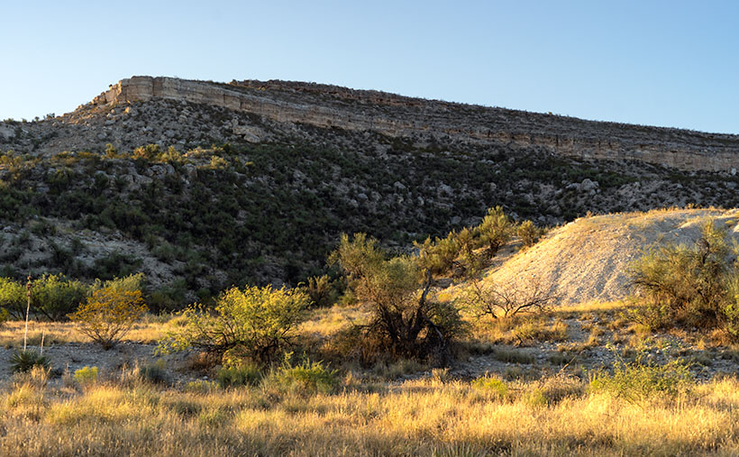
Verde Limestone - A limestone ledge in the Verde River Valley in the lovely light of the evening sun.
Verde Limestone – A limestone ledge in the Verde River Valley shines in the lovely light of the evening sun.

This week, we traveled east along the Verde River for a few miles and stopped near Dry Beaver Creek to photograph a limestone formation. They’re found throughout the valley and are most evident on the river’s north side. As you travel Interstate 17 towards Flagstaff, it’s the white layer between the Verde River and Sedona. Limestone forms in shallow seas from dead shells and bones. It’s a great place to look for fossils, and coincidently one of our planned stops was to be Fossil Creek, but it was closed due to COVID 19.

This week’s featured image—called Verde Limestone—shows a ledge exposed by years of erosion. For balance, I included the lower mound of the same compound shining in the lovely evening sunlight.

You can see a larger version of Verde Limestone on its Web Page by clicking here. Be sure to come back next week as we climb out of the Verde Valley and see what we found along the General Crook Trail.

Until next time — jw

Ferguson Valley Picture of the Week

Queen Anne—as my mother would frequently say—is deaf in one ear and can’t hear out of the other. However, she can tell the difference between me calling, “Anne” and the blood-curdling scream, “Aaannee.” I know this to be true because it happened this week when she rushed to my rescue.

I was busy watering the potted flowers that live on the back deck. We keep them there in the shade during the summer, and I have them arranged on the back doorstep, so the bunnies don’t get to them. It doesn’t work because one or two rabbits will scamper off whenever I open the door. I used my cute water can instead of dragging the hose to conserve water. As I finished the mums, I stepped to the left toward the geraniums. There between the two pots was a western diamondback rattlesnake lying in a wad like a pile of tan rope. It laid there motionless while I involuntarily took a couple of steps backward while I screamed in a voice a couple of octaves higher than my normal range.

When she came to see what the fuss was about, I could only stutter, “porch … snake.” She stepped outside and sized up the serpent, then went back into the house. She quickly returned with a long stick that she had used to knock down a hornet’s nest on the front porch. She marched over to the rattler—which hadn’t twitched yet—took a stance, and began whacking at it. The vermin’s head popped up like it had been sleeping and tried to escape to the left. Anne was too quick and outflanked it, then she took a couple more swings at it. Then the legless reptile reversed course and slithered across the landing before it escaped down a gap between the decking and the house.

“Now what’ll we do? What happens now?” I pestered while dancing from foot to foot like I had to go to the potty. She leaned her stick against the house and went inside and called the fire department. I stood watch, ready to run away the moment I saw any movement. When she returned, she assured me, “They said to leave it alone. It knows it’s not loved and will move on when it feels safe again. If we see it again, we’ll call them, and they’ll come to remove it for us.” I was still upset, and I whimpered while nervously rocking back and forth. That’s when she slapped me across the cheek and commanded me to “Snap out of it.” She went back inside and returned with my camera bag and shoved it into my chest and instructed me to “Shut up and get in the truck. We’ll go take some pictures.”

We drove up the mountain to Skull Valley, where it was cooler. Well, it was under a hundred, and that was better than at home. We turned onto a road named Ferguson Valley Road. The dirt trail is only 6-8 miles long, but there was enough material there to keep me busy in August. The route runs by one cattle ranch and ends at a second. I haven’t found any information about this spot on the map, so I’m surmising that the Fergusons must own one of those places.

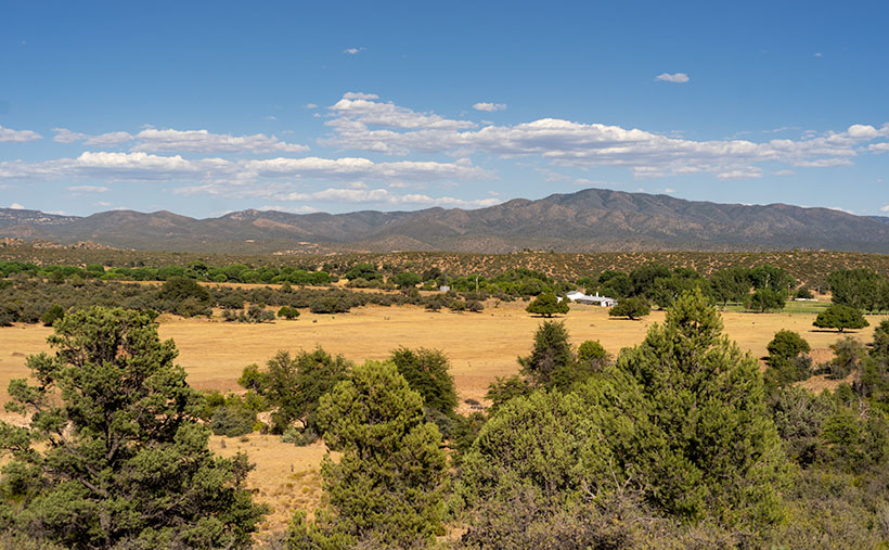
Ferguson Valley - Against a backdrop of the Sierra Prieta range, a white ranch-house sits in pretty Ferguson Valley.
Ferguson Valley – Against a backdrop of the Sierra Prieta range, a white ranch-house sits in pretty Ferguson Valley.

Perhaps they live in the home seen in this week’s featured image. I called this photo Ferguson Valley, and I spotted this scene as we crossed over a low ridge. I liked how the white ranch buildings contrasted with the juniper and cottonwood. I also wanted the clouds forming over the Sierra Prieta range. They speak to the feeble start of this year’s monsoon season. In a typical year, there would be spectacular thunderheads building in the mountains surrounding Prescott.

It’s been several days since we last saw Fang—yes, we named it—so we’re more cautious when we’re outside. We assume the snake is out there, and we actively search for it as we move about the yard. We’re careful to keep the garage door closed, and we work as a team when exiting the house. Anne stands with her back to the wall—stick in hand—and when I open the door, she swooshes through it, scans the area, and then yells, “Clear!” The swat-team imitation repeats a couple of times until we’ve safely reached the car. I’m better now, but if we have many more rattlers visit us, we’re moving to New Zealand—if they ever let us in again.

You can see a larger version of Ferguson Valley on its Web Page by clicking here. I hope you like it. Be sure to come back next week to see another image from this pretty little valley.

Until next time — jw

Red Rocks and Twin Peaks

Last week’s photo—Pair of Threes—was the final good image from the trip where I was Fred’s guest. Although I captured over 60 frames, most of them were variations, or they didn’t live up to my expectations. That happens a lot. But I wanted to share more of the natural beauty in the Wickenburg Mountains with you, so I packed the truck and returned for an afternoon last week. I didn’t make it back to the mine, but I found other lovely scenes to shoot in the area—besides, the sky was being very cooperative.

Sunday didn’t start out all that great, but as the day went on, the gray sky started to break up, so late in the afternoon, I headed back to the San Domingo Wash area. If you’re a regular reader, you know that’s the time of day that I prefer to work. After spending an hour in the field, the light was getting very low, so I started to make my way home because I wasn’t all that keen about getting stuck in some quicksand after dark.

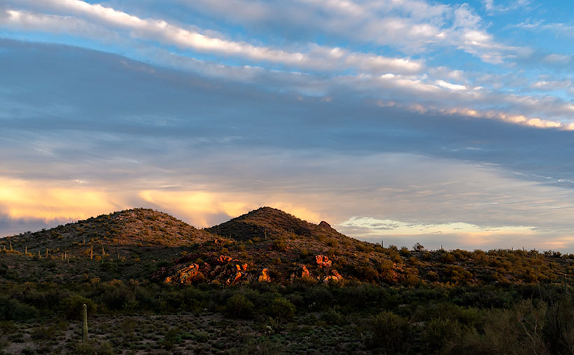
With the sun on the horizon, a rock outcrop glow red before a pair of dormant cinder cones.
Red Rocks and Twin Peaks—With the sun on the horizon, a rock outcrop glow red before a pair of dormant cinder cones.

It was then that I shot this week’s featured image—Red Rocks and Twin Peaks—just as the sun was on the horizon below the cloud line. As I drove, I noticed the rock outcrop glowing red in the setting sun, so I looked for a place where the composition would work. I’m pleased with how there’s enough light to add texture to the desert without adding clutter, but I’m jazzed about the range of color in the sky. After I took this shot, the sun went below the horizon, and I thought, “It couldn’t get any better.” I headed home.

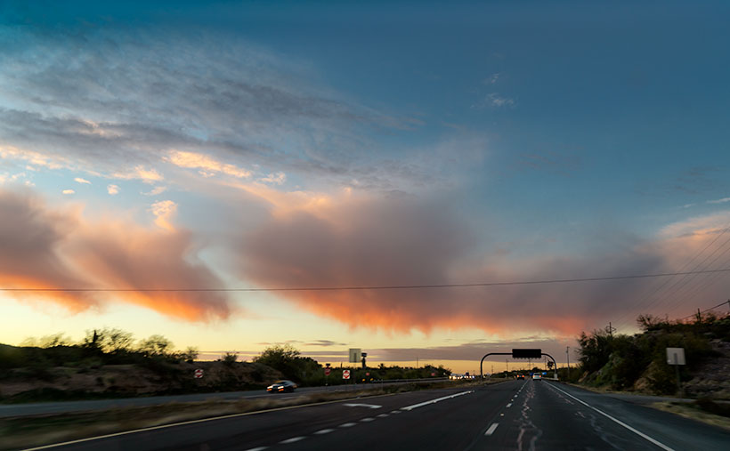
Pink Virga—On the drive home a line of low clouds turned pink with streaks of virga emanating from them. Of course, all I could do is snap a photo through the windshield.

Imagine all of the internal screaming I did when a line of small clouds started showing pink virga as I was driving west on US 60. I’ve only witnessed this phenomenon a couple of times, and it never happens when I’m ready to capture it with a suitable foreground. In frustration, I jammed the camera to the windshield and fired a couple of blind shots while I was driving. Mother Nature can be very helpful to a photographer, but she doesn’t always play fair.       

You can see a larger version of Red Rocks and Twin Peaks on its Web Page by clicking here. I hope you enjoy viewing this week’s post and come back next week when we’ll show another featured image from the Wickenburg Mountains.

Until next time — jw

P.S.: Queen Anne and I would like to send our best wishes to you. We hope your holidays are safe, warm and happy.

The Shrine Under Yavapai Skies

Ask any Arizonan about Yarnell and they’ll most likely tell you about the horrible 2013 fire that swept through the town and the 19 hotshot firefighters that lost their lives when the fire trapped them, in an open field. It’s a big deal for us and to honor those men, Arizona built the Granite Mountain Hotshots Memorial Park. Someday I hope to show that park to you, but I must first build up my stamina to be able to complete the seven-mile round trip trail over a 1200’ elevation rise. For now, I want to talk about another Yarnell attraction that’s celebrating its 79th anniversary this year; The Shrine of Saint Joseph of the Mountains. I’m guessing it’s a place that even most Arizonans haven’t heard about.

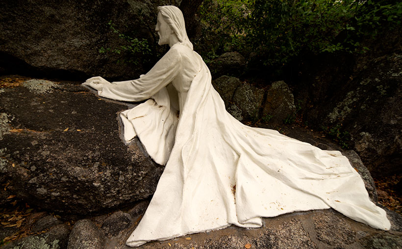
As you travel north on Yarnell’s main street lined with antique shops, it’s very easy to miss Shrine Drive, a paved road on the east side barely wide enough for passing cars. The road winds through dappled shade of scrub oaks lining Harper Canyon. The pavement only lasts a half mile, and when it turns to dirt, it’s at the Shrine parking area. As you get out of the car, the first thing you notice is how quiet it is. Even the birds whisper. You don’t see much at first, but through the trees in front of you, seated at a table is a welcoming statue of Jesus.

Praying Jesus
Praying Jesus – A statue depicting Jesus Praying is an example of Felix Lucero’s artwork at the shrine and makes a stop worthwhile.

The retreat (park, pilgrimage, or however you may interpret its purpose) was the concept of the Catholic Action League of Arizona in 1934. They worked on the plan for four years and contracted self-taught sculptor and unemployed dishwasher Felix Lucero who was living under the Congress Street Bridge in Tucson. Felix’s life is a story of its own and his other collection of work is in Tucson’s Garden of Gethsemane; now know as Felix Lucero Park. The shrine is a representation of the 14 Stations of the Cross—a ritual where Christians symbolically stop and pray at significant events that happened on Jesus’ crucifixion path. The stations at the shrine are along a stair pathway that climbs the mountainside culminating with a sculpture of Jesus on the Cross. Then you continue down the stairs past the last stations until you reach a sculpture representing the resurrection—a slab in an empty grotto draped with a shroud cloth.

Stair Path
Stair Path – The stairs leading to the Stations of the Cross are often Steep. Considering that they already start at a moderate elevation, it’s not an easy journey.

The 2013 fire swept through the shrine site. It destroyed several of the support buildings, charred the trees, and completely burned some of the wooden station crosses. The fire burned away the crucifix on the hilltop completely leaving the sculpture of Jesus floating in the air suspended by bolts welded to a metal frame. Remarkably, the ivory colored statue was not damaged or discolored.

Shrine View – There are places along the path where the canopy opens revealing beautiful views of the surrounding countryside.

I went to Catholic school for four years and that was enough to cure me of organized religion, but as an artist, I enjoy the architecture of churches and the paintings, sculptures, and stained glass within them. I think that’s why I enjoy places like this shrine. I can see the thoughtful planning, hard work, and attention to detail found here. Besides, as you near the top, the tree canopy opens, and you have wonderful views of Yarnell and the Weaver, Bradshaw, and Granite mountains.

The next time you’re traveling the back road to Prescott, I recommend you spend some time visiting The Shrine of St. Joseph in Yarnell. If nothing else, walking the stations is good exercise. Let me warn you that your starting elevation is 4700’ and the stairs are steep. It’s almost a rock scramble; bring water. You’ll enjoy the art, the views, and the serenity. There’s no charge but there is a donation box that you’re welcome to use.

Until next time — jw