White House Picture of the Week

White House - An abandoned dwelling of some sort in the ghost town of Dos Cabezas.
White House – An abandoned dwelling of some sort in the ghost town of Dos Cabezas.

Ghost towns are a big business in Arizona. That’s good because we have our fair share, and a few of them attract many tourists. They’re our Disneyland. As soon as your relatives hit the tarmac and demand to see the state, the first suggestion out of your mouth is, “Let’s go to Jerome (Bisbee-Oatman-Tombstone-etc.).” You’d think that, by definition, ghost towns are abandoned places—they had their heyday long ago, but the residents left when things went south. But, that’s not necessarily true. The population count in some of our mining towns rivals the numbers they had in their prime. Our hometown of Congress is an example. People move here to get away from Phoenix’s smog and traffic—or the Minnesota snow—and they’re all on the road and in my way.

I’ve concluded that somebody loves it and wants to live there no matter how remote one of these places is. Take the town I introduced last week—Dos Cabezas. Among the derelict buildings, there are two surviving businesses. One is an art studio/gallery (Dos Cabezas Art Gallery), and the other is a bed and breakfast (Dos Cabezas Retreat Bed and Breakfast). At least those are the two places that advertise their presence. There are several cattle ranches in the area, and there is an emerging wine presence, but not within the town limits.

I don’t know anything about the gallery, but enjoying a glass of local wine while staring at the stars on the B&B patio would be a treat. Since it’s closer to the Chiricahua National Monument, it’s an alternative to the chain hotels or downtown dives in Willcox. The two guest rooms are in an adobe walled casita, and as the name implies, the hosts include breakfast. A drawback for Queen Anne and I would be dinners. The nearest restaurants are 15 miles away in Willcox or Douglas, over an hour’s drive south. If you’re a person that needs bright lights and noise to sleep, the retreat wouldn’t be your cup of tea—the nights in the middle of Sulphur Springs Valley are exceptionally dark and silent.

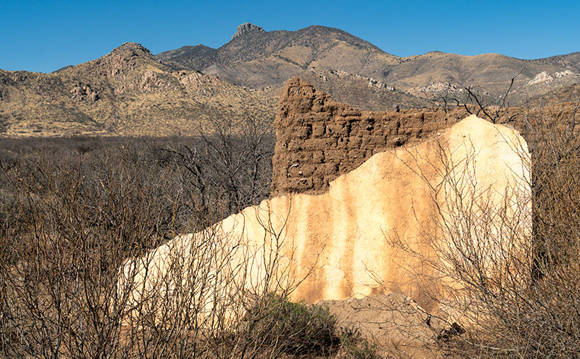
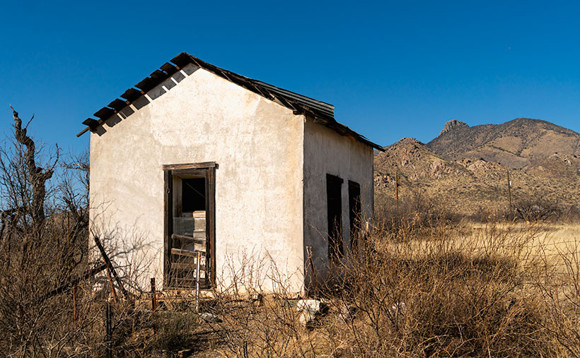
As you can tell from this week’s picture, the little ghost town is at the foot of the Dos Cabezas Mountains. It’s near the range’s southern reach, so you can only see the south head (Cabeza). There’s a road and trails that will get you to the top, where I imagine the view of the valley and Willcox Playa is spectacular. You need permission to cross a locked gate, and the top is steep, so why bother?

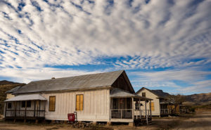
In this image that I call White House, I assume it was a dwelling. It’s a palace compared to some of the miner’s shacks I’ve seen. Unlike the other buildings in Dos Cabezas, this one is a fixer-upper. You have affordable housing with a bit of paint, a few shingles, and a yard clean-up. But there’s probably a community historical committee that needs appeasement, so you can’t paint it purple.

Unlike last week’s photo, the white stucco pops against the brown mountain and clear blue sky, and I like that. There’s plenty of side yard where I visualize Queen Anne hanging laundry on a solar drier. Then, this would be a picture that Norman Rockwell or Andrew Wyeth would envy. Where’s the Saturday Evening Post when you need them?

You can see a larger version of White House on its Web Page by clicking here. Next week, we continue down County Highway 186 in search of an image worthy of another car stop. Please join us.

Till Next Time
jw

Adobe Ruin Picture of the Week

Adobe Ruins - In the ghost town of Dos Cabezas, most of the remaining buildings are severely decayed.
Adobe Ruins – In the ghost town of Dos Cabezas, most of the remaining buildings are in a severe state of decay.

Roughly midway between Willcox and the Chiricahua National Monument, the county highway’s speed limit drops to 45 mph. At first, there’s no clue about the slowdown until a small sign announces that you’re entering the town of Dos Cabezas. Only three of its dozen or so buildings are worthy of occupancy. The rest are in various states of decay. It’s only a city block long, and you soon return to an empty country road, where you can reset the cruise control.

After driving through Dos Cabezas three times, I insisted on stopping on our fourth pass. As regular readers know, I’m a sucker for historic buildings, whether they’re restored or about to be blown down by the wind. I’m glad that I did, and this week’s featured shot is one of several that I captured during that afternoon.

As with most Arizona ghost towns, Dos Cabezas’s history is a flash of glory followed by a long decay period. The town is located at the southeastern reach of the mountain range, which shares the same name. When word came out that prospectors discovered gold and silver on the mountain, miners swooped in like hungry vultures to feed on a carcass. The Feds opened a Post Office in 1878, which served a population of 300 that eventually swelled to over 4000. They found little gold in the Elma mine, but there were some copper deposits. Investment capital dried up when investors discovered that the mine was a scam and part of stock fraud. People left to find work elsewhere. As the town dwindled, the Post Office finally closed its branch in 1960. I guess that you could count today’s Dos Cabezas citizens on one of your hands.

In this picture that I call Adobe Ruin, you see the remains of a large building constructed using adobe bricks and stucco. The town once had a hotel, and these sections may be all that’s left of it. Adobe was a common building material throughout the old southwest because it was simple to make. All you need is to combine mud and straw and let it dry in the sun. The thick bricks provide plenty of protection from the desert heat and cold winters, but they quickly erode once water enters them.

I took several variations of the building, but I favored this one because I liked the mud stains streaking down the wall, and I liked the wall’s placement before the background’s two-headed mountain. The desert willow and hackberry show how soon nature reclaims her own. Ashes to ashes, as it were.

You can see a larger version of Adobe Ruin on its Web Page by clicking here. Next week, we’ll walk down the street to look at another of the Dos Cabezas ruins. Come back then and have a look.

Till Next Time
jw

Ray Tailings Picture of the Week

Queen Anne's directives - From her royal coach, Anne delights in pointing the way we should've gone.
Queen Anne’s directives – From her royal coach, Anne delights in pointing the way we should’ve gone.

Picking a new back road to explore, photograph, and talk about is easy for some months. I may have seen a place that piqued my curiosity, and I’m ready to go. Other months are hard. I’ll pour over my maps, hoping to find inspiration. This month was different. When Queen Anne told me that she wanted to visit an ex in Florence (1), I knew right away which trail we’d be talking about in November. Of course, we’d pick the Florence-Kelvin Highway.

The highway between Florence and Kelvin is a 34-mile shortcut between the towns. Although it’s 13 miles shorter, driving around the Tortilla Mountains and through Superior using the paved highways is faster. I’ve partially traveled this road before when I photographed the Cochran site—the ghost town where only the coke ovens remain. They paved sixteen miles of the highway between Florence and the Cochran Road. It’s a long gentle grade rising 1500 feet. Then it winds through the Tortilla Mountains, past a couple of ranches, before descending into Kelvin—a small community along the north bank of the Gila River. Although there may be some wash boarding between gradings, the dirt is broad and doesn’t require a particular vehicle.

On this trip, Anne and I drove east to west, so we’d be somewhat closer to home. From Congress, we drove two and one-half hours to Superior, and most of that time was spent getting to the other side of Phoenix. In Superior, we turned south on County Road 177 to Kelvin—a community so small it doesn’t even have a Dollar Store. Something that Kelvin does have is the Ray open-pit copper mine currently managed by the Mexican mining company, Asarco. And it’s where I photographed this week’s featured image that I call Ray Tailings.

Ray Tailings - A 500-foot tall inside out mountain of mine tailings.
Ray Tailings – A 500-foot tall inside out mountain of mine tailings.

This operation is so massive that you see it on the east side of the highway for a couple of miles. The central pit—Jimmie Luck Gulch—looks like it could be used to mold giant Devo hats (“Whip it good“). In the middle of the Dripping Spring Range, the mineworkers have dug a negative mountain with terraces that the behemoth trucks use to haul ore to the surface. Digging that much dirt out of the ground to remove the copper, you have to stack the sterile waste somewhere, and that’s what I photographed for this week’s issue. It’s the mountain stacked up—inside out. The minerals found beneath the surface colors each layer. To me, the 500-foot pile looks like a gay-pride wedding cake.

It’s an impressive bit of technology to see, but it also causes environmental problems. Because the rocks and dirt are devoid of nutrients, unless scientists intervene, it will take centuries for plants to colonize the tailings. So that makes them susceptible to accelerated erosion. With each heavy rain, bit by bit, the pile makes its way into the Gila River and eventually the Sea of Cortez. That’s not good for the downstream people who rely on the river for clean water (Arizona Copper Co. vs. Gillespie).

You can see a larger version of Ray Tailings on its Web Page by clicking here. I hope you enjoy viewing it. Next week, we’ll continue along the Florence-Kelvin Highway, and I’ll show some of the natural beauty we found there.

Until next time — jw

(1). For those of you that live in another state, or don’t get the joke, Florence is the location of Arizona’s State Prison. She doesn’t really know anyone incarcerated there, but that’s not as funny.

Stanton—The Outlaw Ghost Town Under Yavapai Skies

My lovely bride abandoned me for a couple of days to get her annual check-up at a beauty spa on the Arizona Rivera—Lake Havasu City. Before she climbed into her friend—Yasmeen’s—car, she turned to me and with a pointed finger and sternly said, “I have two words for you. Be – have!” Well … that sounded like a challenge to me, so I began thinking about what kind of trouble I could get into. I was in the mood for a photography outing and I hadn’t been to Stanton since Fred and I got lost, so I tossed my gear into the truck and set off to get some new photos.

Hotel Stanton
Hotel Stanton – During the Summer of Love, hippies moved in and set up a commune. Unfortunately, they tore down many of the old buildings for firewood. LDMA has slowly repaired the remaining structures since acquiring the town in 1976.

Stanton is one of the many towns in mountainous Yavapai County (rhymes with have-a-pie) where, because someone discovered gold, a town sprung up overnight and disappeared just as quickly when the ore played out. It was little more than a stagecoach stop on the Wickenburg-Prescott road at  Antelope Creek until a tracker named Alvaro chased an errant burro to the top of what is now Rich Hill. When he got back to camp and told the expedition leader—Pauline Weaver—about finding gold nuggets “the size of potatoes” on the summit, you can surely guess what happened next.

Opera House
Opera House – The Opera House is an adobe building with a brick façade. It’s now used as a meeting hall for the RV Park.

The town—known at the time as Antelope Station—got its name from an unscrupulous character named Chuck Stanton who moved to the thriving community several years later. Stanton opened a store and, with the help of his hired banditos, killed off his competition. His reign didn’t last very long as he was shot and killed that same year (living with swords, I guess). The town thrived afterward for several decades but it had a bad reputation. “In 1892, for example, a Prescott newspaper reported that the residents of Stanton liked to ‘drink blood, eat fried rattlesnakes and fight mountain lions’” (Wikipedia). By 1905 the gold ran out and Stanton was abandoned.

Stanton Homes
Stanton Homes – Only three houses have survived the years of abandonment. They line a street surrounded by campers.

Ownership has changed several times since then and now it belongs to Lost Dutchman’s Mining Association (LMDA) and they have turned it into a member’s only RV Park. Membership is kind of pricey but LDMA has methodically bought up mining claims in the area and its members can work those old claims without charge. It’s surprising how many people will pay good money to play in the dirt—I don’t even like to plant flowers. Guests are allowed to visit but they first have to stop by the office and sign a release.

After my visit this week, I drove further down the road to the old Octave and Weaver mine sites and saw people on either side of the road prospecting. Late in the day, I stopped to take a photo along the roadside at quitting time when several trucks pulled out of a side road. They all slowed and waved and one of the men stopped to ask if I was getting some good shots. I asked him how his day went.

“What do you mean?” he asked.

“Did you make a fortune today,” I explained.

He laughed and replied, “Only the boss makes any money.”

“I see.”

Then he started telling an old joke, “Do you know how to make a small fortune in placer mining?”

“Yeah, you start with a big fortune,” I responded.

With that, he laughed and drove off in a big trail of dust.

Until next time — jw

The Town That Never Was Under Yavapai Skies


Robson Mining World Sign
Robson Mining World Sign – The entrance to Robson Mining World is bullet-riddled Yavapai Apache riding a pinto.

I grew up during the era of the TV cowboy. After dinner, my family would gather in the living room and watch shows like Gunsmoke, The Rifleman, Maverick, and Have Gun—Will Travel to name a few. My dad was a tyrant about the shows we watched and we kids were the remote. Maybe that’s the reason I—and perhaps all my generation—have a fascination with ghost towns. We grew up with Tombstone, Dodge, and Virginia City on our TVs, and vowed to visit them one day. Maybe we’re longing for a simpler time—when the good guy wore a white hat.

The ghost towns best known in Arizona are Jerome, Tombstone, and my favorite, Bisbee. All of these places have residents, so they’re not as much a ghost town as they are tourist traps. A mining town’s fortune is dependent on the mineral wealth removed from the ground. The town’s size correlates perfectly with the amount of ore; be it gold, silver or copper. As soon as the ore plays out, people move on to the next bonanza leaving the hovels and shacks they occupied behind. Without maintenance, those relics soon rot or they’re repurposed for sheds, outhouses, or worst of all, firewood. Most often, when you visit a ghost town, the only things you find are a slab or wall. There’s not much interesting left to photograph. Fortunately, there are exceptions where a state or county government acquired and preserved the scene as a park, such as Bodie and Calico in California.

Yavapai County, where Queen Anne and I live, has its share of Ghost Towns—including Jerome—the most famous. Most of the old sites are high in the Bradshaw Mountains, but mining towns are scattered throughout all the Yavapai mountain ranges; including Congress—our hometown. It wasn’t until we moved here a couple of years ago that I learned about the best ghost town ever, and it’s a mere fifteen miles down the road tucked into the south-eastern flank of the Harcuvar Range.

Travel west on Highway US 60 and Aguila is the first small farm community you’ll come to. The name is Spanish for Eagle derived from the eagle-shaped window in the low mountain overlooking the town’s cemetery. The western terminus of Arizona State Route 71 is a mile east of Aguila, and that’s the short-cut you take if you’re heading northeast to Congress or Prescott from California. Just before the road crosses the Maricopa-Yavapai County line is a sign with a bullet-riddled Indian riding a pinto horse. The sign is for Robson’s Mining World—the ghost town you can see at the mountain base. It’s a mining town that no one ever lived in, but has an interesting story nevertheless.

Robson Ranch Booth
Robson Ranch Booth – When you enter the town’s soda parlor, you’d expect to order a milkshake. You’d be disappointed because it’s all for a show.

The gold mine at the end of the trail was first claimed in 1917 by Westley Rush, an Aguila melon farmer. Rush’s two daughters—Nella and Alameda, for whom the Nella-Meda gold mine was named—managed to hand dig through the first 115 feet of solid rock before Ned Creighton—a Phoenix banker—bought the claim in 1924. Ned hired a crew to work the mine, and over decades he expanded the claim to its present size. His crew worked until World War II when the Feds shut down all private mines. The mining engineer, Harold Mason, stayed on as caretaker and eventually got the property deed after Ned passed.

After the war, Charles Robson was building his fortune by farming, running the Saguaro motel in Aguila, and hustling the health benefits of his local bee pollen. Harold and Charley became acquaintances when Mason let Robson place hives at the mine. There were minerals around the mine that made the bee pollen exceptional and the bees deterred poachers. That informal partnership lasted until 1979 when Charlie bought the mine from the aging Mason. Robson had bigger plans for the place.

Cash Register – What this old cash register lacks in functionality, it makes up for with class.

Meanwhile, in 1922, Wilber T. Johnson migrated from Missouri to Apache Junction—a community east of Phoenix at the foot of the Superstition Mountains—so he could work in the mines. In 1930, Wilber traded his pick and shovel for an engineering degree from the University of Arizona which made him a highly valued employee. Now we’d call Wilber a hoarder because he collected mine junk—lots of mine junk—for the next fifty years. Johnson got his stash from abandoned mines in the Superstition Mountains, the Mazatzal Mountains, and other mines east of Phoenix and because of its size, his collection wasn’t a big secret. He reputedly turned down a multi-million-dollar offer from Disneyland Tokyo because he knew that they cherry pick the best and discard the rest.

Mack Truck
Mack Truck – A classic truck that miners used to haul stuff.

After Charles Robson acquired the mine, he offered to buy Wilber’s collection and the two men finally struck a deal when Charlie promised that the collection would stay intact on Robson’s property. The ink on the signatures hadn’t dried yet before more than 250 truckloads moved decades of mining history to its new home. For ten years Charles, his wife, Jeri, and their sons reassembled the buildings and filled them with the collection’s artifacts. After Charlie died in 2002, Jeri carried on the dream, and toward the end of her life sold the place lock, stock, and barrel to Western Destinations Corporation—the present owners—on the stipulation that nothing ever leaves the property.

Water Truck
Water Truck – A GMC truck that was used to haul water up from the well to the mine.

There’s a small garden in front of the Opera House where we sat in a mesquite tree’s shade as Brett Bishop told me this story. He’s the current caretaker and he and his family live on site. He’s a young man, and when he’s not greeting visitors he keeps busy unpacking the remaining crates and creatively arranging the contents for display. It’s easy to tell—from the tone of his voice and the sparkle in his eyes—that he loves his job. He calls Robson’s a living museum and he often must unravel the mystery of the items he finds in the boxes.

If you’re a photographer interested in nostalgia, I highly recommend a visit. The cost is $20.00 per person which goes toward upkeep. Don’t count on food or entertainment and even the restrooms are period authentic—that’s right; crescent moons. The mile-long dirt road is navigable by a sedan, except after heavy rains. I know that Robson’s will become one of my resources.

Until next time — jw

Fred and Jim’s Excellent Misadventure

My friend Fred got a new toy for his birthday. For the last couple of years he’s been lusting for a SUV (Sport Utility Vehicle). If you’re not familiar, those are off-road buggies powered by snowmobile engines. In Congress, they’re all the rage and have all but replaced golf carts.

Last month some folks in the park sold their home and advertised their SUV on the local bulletin board. It was just the one he was hankering for, so he kilt it and brought it home for Deb. Her only comment was the smoke coming out of her ears. She looked like her power supply burnt up. It’s bright yellow Can-Am, so I tagged it Tweety, after the villainous cartoon canary that brought grief to Sylvester the cat.

Fred was all excited when he brought it over to show me. The first words that came out of my mouth were about him being forced to sleep in their trailer. After a ride around the block, we concluded that it needed a shake-down cruse. After comparing honey-do lists, our first common free day was last Thursday. We decided on a route that circled the house and would never be more than ten miles away. We were going to drive up to Stanton (a mining ghost town that is now an RV Park) then stop at the old Octave mine and finally drive the back roads home. I could bring my camera and get some shots along the way. The whole trip would take about three hours and we’d be home by dinner.

On Thursday, I cleaned my camera, charged up spare batteries and noticed that the memory card door was open, so I made a mental note to put a fresh SD card into the camera and pack a couple of spares. Fred showed up right on time at half past two. After some last-minute adjustments, including a heavy sweater and packing water, we set off.

Along the sides of US-89 there are trails that people use for SUVs and ATVs. That way they aren’t obstructing highway traffic. We drove the north-bound trail to the gas station to top off the tank. By the time we reached the station, the novelty of riding in the open and jostled about had already grown thin. There’s no heater, no doors and the only thing keeping you inside are the seat belts and a couple of strategically placed grab bars. After getting gas we had to drive the highway for another couple of miles before turning onto the dirt road that goes to Stanton. We watched the mirrors carefully for traffic and pulled to the shoulder to let cars go by.

When we reached the Stanton road, Tweety was in her element and we sailed along at a decent clip. It’s only a half-dozen miles to the ghost town and I worried that we were too early for the ‘magic light’, but we pulled into the RV Park to check it out. There are a few dwellings remaining, surrounding a Saloon (serving as an office), hotel and the remains of the old brick opera house. I wandered off to reconnoiter the buildings while Fred stopped at the office. He found out that it isn’t a park at all, it’s a mining association. Like a timeshare, you buy into the place and in return you can park your RV and work any of the claims that the association owns. Because he registered as a guest, they gave us permission to hang around and shoot some pictures, so I went for my camera and when I pulled it out of the bag; I saw that the card door was still open. I forgot to pack film; so much for the photo shoot.

We soon were off to the Octave Mine. As we drove, I made mental notes of photo locations. I also noticed that the area was crawling with prospectors working active claims. The area along the Weaver Range had several productive gold mines in the 19th Century, but they had all played out by the 1920s. Even so, along the road were gates with “No Trespassing” signs. Being very protective, when a miner’s sign says “violators will be prosecuted,” that usually means shot.

Since we didn’t have to stop for photographs we set out to find the road that would lead us home. To keep us from getting lost, I brought a topographical map and my GPS. We used them to navigate the maze of trails that crisscross the area. We would go till we found an intersection, take a reading from the GPS and find our place on the map. We sort of could figure where we were but the map and GPS seemed to disagree by about a thousand yards. By using our heading and the terrain, we could interpret our site on the map. We drove by a windmill and cattle tank (a lovely shot), we used as proof that we knew we weren’t lost.

According to the map, all we had to do was go north from the windmill a hundred yards, turn west on a jeep trail, drive south through Antelope Creek for a quarter-mile and the road we were looking for would be on the right. We’d be home early.

We quickly found the trail which led down a steep bank into a creek bed. As you’d expect, there wasn’t much of a road down there. Just intermittent tire tracks along the boulder strewn ravine. Tweety’s ease in traversing the rocky path impressed us. We concluded that this thing would go anywhere. About a mile later the trail climbed up the bank heading south and skirting a low hill. We’d missed our road, so we turned off and headed back north only to find ourselves back at the windmill.

Fred drove around for another hour searching for a way out of the maze. We were losing light and the temperature began to drop. I was glad I’d put on a heavy sweater under my jacket. When we drove by the windmill for the fourth time, the sun was almost down and we stopped to check the map. We conceded and gave up our search. The map showed that the road north would take us directly to the main Stanton road, so we decided to go home that way. Although the map said this was a major trail, it was just a couple of ruts that wove between the creosote and cactus. We could at least follow it even after we had to turn the headlights on. We dodged some cattle along the way and passed an occupied trailer.

It was dark when we drove up to the fence clearly marked “No Trespassing.” The road had come to a dead-end. We got out and looked around. Beyond the house in front of us, we could see Stanton and our road home. We backtracked a bit and discovered that the real road turned to the right which we missed in the dark. It led down a steep hill so I took the flashlight and walked in front of the buggy. At the bottom were two concrete pillars with a padlocked cable stretching between them. A sign hung in the middle which said “No Trespassing,” but that was on the other side. Aargh, somehow we had gotten on private property and it was dark in mining country.

Fred turned Tweety around and we drove back over the hill and then descended the other side. I’m not sure we were on a road, but we saw tracks which led to another locked gate and warning sign. We tried to find another way but instead just drove in circles. We couldn’t find the way in. We stopped for a while to strategize. My GPS lays cookie crumbs so we used that to retrace our steps. We decided that we had to return to the windmill and take the long way back. Fred suggested that we stop at the trailer we passed and ask for help. With that, we started re-tracking the GPS dots.

When we reached the trailer it was dark, but there were dim lights coming from inside. Fred stopped the buggy and I got out. I didn’t want to frighten anyone so as I approached the home, I held the flashlight on myself. Ten yards away I stopped and yelled, “Hello! Hello! Is anyone home in there? We need some help. Hello!”

A dog barked and that’s always a bad sign. I repeated my cry. Then Stephen stumbled out of the front door followed by a black and white puppy. “Yes officer, how can I help you?” he slurred. Were he driving, he would never have passed a breathalyzer test. Though he was fully clothed, judging from his tossed hair and disheveled clothing, we must have woken him. I moved closer to avoid having to yell. I introduced ourselves and explained our plight.

“I am a retired Air Force Commander,” he started then veered off into a paragraph of disjointed sentences. “I’m here to help you. Are you military?”

I explained that Fred was an Air Force veteran and I was in the Army, but that was long ago. “No matter,” he went on, “once military always military.” Then he let out another batch of seemingly unrelated sentences. Fred walked back to the buggy and started it.

“You said you could help,” I almost pleaded.

“I can, but your friend is rude,” he observed.

“He’s tired and frustrated, as I am. How can you help us?”

“Come inside where it’s warmer,” he said picking up the pup then stepping back into the trailer and although Dueling Banjos played in my head, I followed.

The inside of the trailer was only a bit wider than our Casita, but longer. A galley was on the left and a mattress filled the right. Neither had been recently cleaned. On the counter were two open cans of beer; a brand that hasn’t been sold in Phoenix for decades. Dishes piled up in the sink next to a rusty stove. There was a neat pile of roaches (the joint kind) in a saucer next to the door.

He tried to start another round of military conversation, but I was getting frustrated by then. I was about to give up, but instead, I cut him short. “Look, I’m tired, hungry and, frankly, a bit scared. You said you could help, but you’re not. How can we get to the Stanton Road and go home?”

“Where did you come from?” he asked.

“Congress,” I replied.

“No. I mean, how did you get here?” He was trying to analyze.

I again explained how we had taken his road, but when we went further, it was a dead-end.

“You see,” he started, “you take this road all the way and it makes a right turn down the hill.”

“Yes, but there’s a locked cable across the road,” I responded.

“I’m a retired Air Force commander and my job is to look after this land for the mining company,” he explained.

“How does that help?”

“I have the key!”

“Oh great,” I thought. How are we ever going to pile him into his truck and get him to unlock the chain? He could barely stand, let alone drive. Meanwhile Fred had shut off Tweety’s engine and was now standing behind me. “Can you come and unlock the cable for us?”

“No.”

I started again to beg his mercy, but he cut me short. “I’ll draw a map and give you the secret.” He got a sheet of paper out and began a loose interpretation of a map. I watched as he drew the road, the curve, the concrete and wire. When finished he explained, “From this pillar, about ten steps due north, is a tree stump. On the east side there is a rock at the base that covers a hole. Inside the hole is a chew tobacco tin with the key inside.”

I reached inside my pocket but couldn’t find my money clip, so I turned to Fred and gestured that I wanted some money. He handed me a five dollar bill and I turned and pressed it into Steve’s palm while shaking it. We expressed our gratitude and nearly tripped over the puppy as we ran out of the trailer.

Once we started the three-mile journey, I yelled to Fred, “If we don’t find this key, we are not stopping back at his trailer.”

He yelled back, “If we don’t find a key, we’re driving through the gate.”

Once the cable was in sight, I got out and walked to the pillar. I looked to the sky for the North Star and began to step off; one, two, three, four, five . . . OMG there was actually a stump, and the described rock. I pointed the flashlight on the rock and moved it revealing a hidden hole. In the desert, you never stick your hand into someplace you can’t see, so I pointed the light and saw the green Copenhagen tin and took it out. Inside was a little brass key. Allll-right Stevie!

I opened the padlock and dropped the cable so Fred could drive over it. After locking the cable and putting everything back in its rightful place, I jumped into Tweety and we drove twenty-five yards to what now had become the Greater Stanton Freeway. We stopped so Fred could call Deb and give her the good news. “How long will it take to get home?”

We didn’t talk much on the half-hour drive home. I noticed that I had gotten cold, so I buried my hands into my jacket pockets and tucked my nose into my collar. There wasn’t any traffic on the highway, so Fred coaxed every mile-per-hour that Tweety would go on the paved road. The knobby tires screeched at a pitch that sounded like constant phone ringing.

It was 9:15 when we arrived at my house and after unpacking my gear, Fred drove off. From what I hear, Fred can keep his toy. He just can’t go out with me ever again. Oh well; such is life.

Till then . . . jw