Gleaming Stainless Silos: Shining Icons of Agriculture Picture of the Week - Aguila, Arizona

Gleaming stainless steel silos in a cotton field, reflecting the morning light
Gleaming Stainless Silos – Bathed in the soft morning light, the stainless steel silos stand tall amidst the green expanse of a newly planted cotton field. A testament to modern farming and agricultural storage, these gleaming giants symbolize the promise of a bountiful harvest.

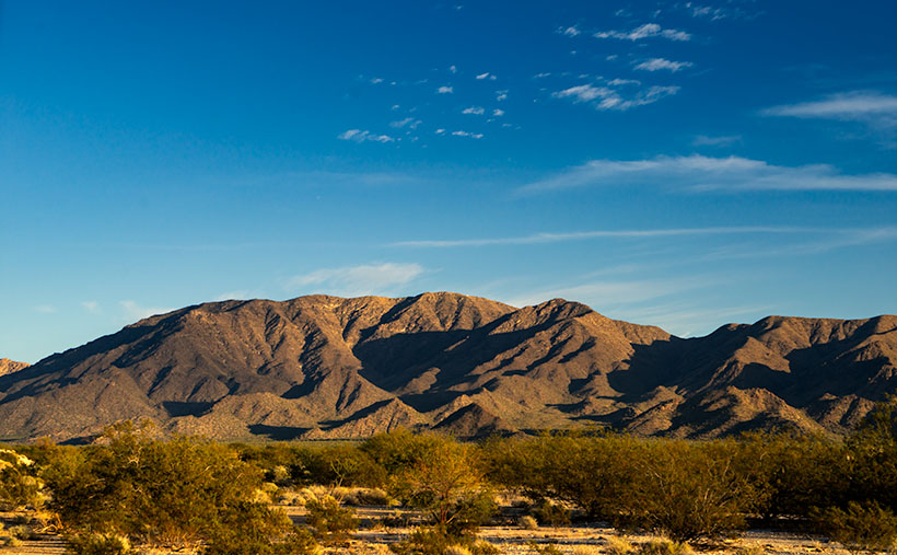
Welcome back to the third image in our May orphan photos project. We hope you’ve been enjoying the journey so far. Last week, we took a nostalgic look at some old farm equipment, but we’re shifting gears to bring you something new, and I didn’t have to travel far to find this week’s subject.

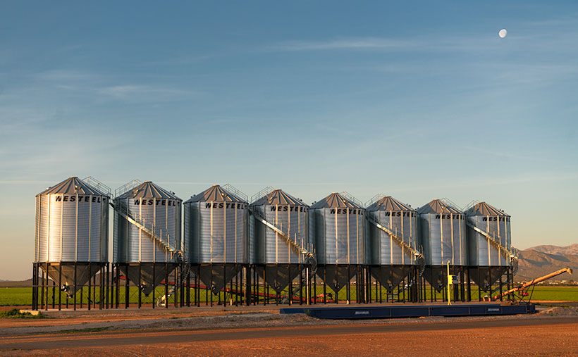
During our travels, Queen Anne and I often find ourselves driving through the charming town of Aguila—though calling it a town may be a bit generous. It’s more like where the tumbleweeds stop to stretch their legs, and the cacti gather for a gossip session. It has been the subject of my playful jesting in the past, but today I’ll take a lighter tone. Aguila is situated along route US 60, west of Wickenburg, and as I’ve mentioned before, it serves as the quickest route for Queen Anne and me to reach Interstate 10. On one of our recent journeys through Aguila, a remarkable sight caught my attention—a magnificent set of silos erected on a cotton farm. Their towering presence against the horizon immediately captured my imagination. As a photographer, I’m always searching for unique and captivating subjects. These silos presented the perfect opportunity to catch something unique.

Regarding my photography, I enjoy sharing my work with a broad audience, and one platform that has been instrumental in reaching a larger community is Unsplash. For those who may not be familiar, Unsplash is a platform where photographers can showcase and share their high-resolution images, allowing anyone to download and utilize them freely. I take great pleasure in contributing to this platform, and I currently have around 100 of my photos available there. (You can check out my Unsplash portfolio here :[https://unsplash.com/@jcw].

Among the images, I have posted on Unsplash, two particular silo photos have garnered significant attention. These silo images, which I previously captured and uploaded, have become some of the most popular in my collection. The two silo photos alone have amassed over 1.5 million views and have been downloaded more than 1,100 times. This positive reception motivated me to seek out new and captivating silos to add to my Unsplash portfolio, and that’s where this photo comes into play. Who would have thought that a collection of silos could attract so much attention? Move over cute puppies and stunning landscapes; it’s time for the silos to shine. Maybe they have some secret magnetism, or perhaps it’s just the allure of all that grain storage. Either way, these silos have become the unlikely celebrities of the photography world.

When I laid eyes on these gleaming stainless silos in Aguila, I knew they possessed the potential to enhance my Unsplash portfolio and further boost my numbers. I took this photo with a mixture of artistic vision and a touch of self-interest, fully aware that the unique beauty of these silos would resonate with viewers. It’s fascinating how an ordinary subject like silos can captivate and draw the attention of so many people.

Ultimately, my decision to capture this image was driven by a desire to continue sharing my work with a larger audience and expand my presence on platforms like Unsplash. The allure of these silos and the previous success I’ve experienced with similar images solidified my belief that this photograph would be a valuable addition to my Unsplash portfolio.

When you gaze upon this photo, it’s like sipping a Pousse-Cafe, with each tier offering its delightful flavor (If you have no idea of what I’m referring to, here is a recipe: https://www.epicurious.com/recipes/food/views/the-pousse-cafe-no-1-51167400). At the bottom, we have the earthy essence of the brown dirt road, followed by a refreshing burst of green from the newly planted cotton fields. And finally, the pièce de résistance, the shining stainless steel silos, add a touch of sophistication to this visual libation. And just like a perfectly crafted drink, we have a cherry on top—the waning moon gracing the composition like a delightful garnish. It’s a photographic concoction that will tickle your taste buds and leave you wanting more.

To enhance the curves in the seed containers, I find the light from the sun at a low angle the best. The tanks would look like cardboard cutouts if you shot this scene at noon. Either end of the day works fine, but since I got up early, I got a lovely moon in the bargain. I had to move left to get that moon into the shot, introducing a perspective. In this case, it works better than a static head-on point of view.

I hope you enjoyed this week’s photo and story. These gleaming stainless silos in Aguila serve as a testament to the agricultural essence of this small town. They stand tall, surpassing any yard art or decorative statues, and remind us of the remarkable structures that farmers create as they cultivate the land. The silos embody the local community’s hard work and dedication, showcasing agriculture’s beauty and importance in shaping our surroundings.

To fully appreciate the visual impact of the Gleaming Stainless Silos, I invite you to visit the official webpage, where you can view the photo in all its glory. Follow this link [https://www.jimwitkowski.com/newWork/gleamingSilos.html] to immerse yourself in the fascinating details and explore the nuances captured in this image.

Thank you for joining us this week as we delve into the world of agricultural beauty and the stories behind orphan photos. We appreciate your support and the moments you’ve shared with us. Be sure to mark your calendars for next week’s finale as we unveil a special place in Arizona’s history. It’s an extraordinary journey you won’t want to miss. Thank you for giving us a moment of your time.

Until next time
jw

BTW:

The snake count is two a peace. Ours was a 10′ bullsnake on a mission. He was headed west, and nothing would get in his way. No matter how much I tried, he would not turn around. When I annoyed him enough, he slid under the house. But, the neighbors spotted him later in the evening leaving the park like Horrice Greely personally spoke to him.

Fred and Deb’s story has more drama. Their snake was a baby rattler hiding next to their front hose. When spotted, Fred got a shovel and pitched it into the middle of the street, but the snake had bitten their youngest dachshund. Odie got pretty sick for a while, but he’s feeling better and resting at home. You should run out and buy him a get-well card.

Eagle Eye Cliff Picture of the Week

There’s trouble brewing for me. In this case, it’s a good problem—it’s mischief, really. My conflict is a clash between my annual wanderlust and self-preservation. Sitting on each of my shoulders is an angel and a devil (they’re a metaphor, I don’t really see them, so don’t send a paddy wagon after me). The good one tells me to take the long-term view, while its counterpart tempts me with immediate gratification.

Arizona’s winters come in two parts; cold and wet. They’re relative, of course, nothing like what you see in other parts of the country, but hey, it’s what we’re used to. During the cold period, our weather drops in from the Gulf of Alaska. The second half of our winter is wet because the incoming storms originate over the Pacific. In between these mini-seasons, high pressure settles over the State, and we have warm, sunny days and cool evenings. This period of ideal weather can last from one to six weeks. Last year, we skipped the wet part and went straight to summer.

Last week we had a cold front move through our state with high winds and cloudy skies. It left us and went to Texas, and you can see what happened there. But the second half of the week was sunny and clear. The air was so clean; you could make out boulders on distant mountains. I immediately knew that this is our mid-winter lull. I say we should close the Arizona border so outsiders don’t find out why we live here.

Thursday morning, I took my cup of coffee out onto the back of the deck, and I got that familiar feeling in the pit of my stomach. I need to be on a boat somewhere with a fishing line tied to my big toe while I nap in the sun. This is my annual spring wanderlust, and I want to go somewhere—anywhere. I’ve had enough of winter; I’m ready for adventure.

But, we still have this global plague to deal with. Queen Anne and I have received our first vaccine dose, and next week, we get the second. However, that isn’t a Get out of jail free card. We still have to constrain ourselves. I don’t know how much more willpower I have. I’m really ready to flick the angel off my shoulder and drive to the coast to taste the new wines, visit some Santa Fe galleries, or explore Utah’s Henry Mountains, anyplace but Aguila.

Eagle Eye Cliff - The cliffs on the south side of the Eagle Eye Mountains shows that there is limestone foundations under the lava.
Eagle Eye Cliff – The cliffs on the south side of the Eagle Eye Mountains show limestone foundations under the lava.

But since we’re still stuck in Aguila, let me show you this week’s featured image. I call this one Eagle Eye Cliff. It’s from the same pair of mountains as we’ve explored for the last couple of weeks. The two peaks are the eastern end of the Harquahala Range and are dwarfed by their big brother next door.

I’ve already talked about how the Eagle Eyes are covered in lava, but you can see a limestone foundation underneath in this shot. I don’t know if the white cliff is the remnant of an old reef or the volcanic stone shielded it from erosion. To me, it looks like sloppily done chocolate icing on a white cake. That’s barbaric. Everybody knows that white cake should have caramelized pineapple on it.

You can see a larger version of Eagle Eye Cliff on its Web Page by clicking here. Be sure to come back next week, and I’ll show you the final shot that I liked from my outing in Aguila.

Until next time — jw

Eagle Eye East Picture of the Week

My sweetie loves me! Incredible, I know. After living together for over 32 years, this morning, on Valentine’s Day, she asked me what I would like for a romantic dinner. The question took me by surprise. I had to think about it. I puzzled about which meals nurtured the minds and souls of great artists. What’s the most romantic place I can think of? Then it hit me—Giverny, France of course—home of Claude Monet. So I looked up the restaurant menu from Hotel Baudy—a scene in several of his paintings and where he gathered with many of his Impressionist cronies.

I Google translated each menu item looking for something manly and not cheesy. Halfway down the list, the obvious choice jumped off the page. It has three of the world’s best things you can put in your mouth in one dish: Magret de canard poêlé aux cerises et sauce au porto—seared duck breast in a cherry-port sauce. Ah—I slobbered all over my keyboard, thinking about it.

I rushed into the living room where Queen Anne was reading the Sunday paper dressed in her threadbare robe, fuzzy slippers, and rollers. I blurted out my dinner choice. I guessed wrong. She explained that what she meant was, “Which of the packages in the freezer do you want me to microwave for you—and you can’t have the one that I picked.” <Sigh> So, I picked the other TV dinner. Ain’t love grand?

Eagle Eye East - The view from the top of Eagle Eye Mountain looking east towards the arch on Eagle Eye Peak in Aguila, Arizona.
Eagle Eye East – The view from the top of Eagle Eye Mountain looking east towards the arch on Eagle Eye Peak in Aguila, Arizona.

Letting my romance wilt on the vine, let’s talk about this week’s featured image. As I promised last week, I wanted to show you the Eagle Eye Arch from another angle. In this image—that I call Eagle Eye East—we’re looking at the arch from the south side of the mountains in Aguila. I shot this picture from the top of Eagle Eye Mountain facing Eagle Eye Peak, and that’s why the arch seems more distant than last week’s photo. Since this was the sunny side of the mountains, it better shows how rough the lava surface is. I like how the bright green saguaro and palo verde contrast with the reddish-brown rocks.

Another interesting thing in this image—to me—is the background mountains. The Forepaugh Range is on the right and beyond them is the town of Wickenburg. Beyond the Aguila Valley, the tall mountains on the left horizon are the Weavers, and that’s where we call home.

You can see a larger version of Eagle Eye East on its Web Page by clicking here. Be sure to come back next week, and I’ll show you the final shot that I liked from my outing in Aguila.

Until next time — jw

Eagle Eye Peak Picture of the Week

The last time I wrote about Aquila’s Eagle Eye was in 2018, and I didn’t have much to say about it—other than it was there. That post included a photo that I shot with a telephoto lens from miles away. I had to do that because a lot of the land around the peak is posted as private. There were two comments on that column. The first was from Fred, who thanked me for pointing out the bridge to him, and the second was from my old friend Gary who chastised me for not getting closer.

This month—since I’ve been hanging around Aguila anyway—I thought I’d try to make Gary happy. About three miles south of Aguila are mountains on the east flank of the Harquahala range. They almost have the same name; Eagle Eye Mountain is on the west while Eagle Eye Peak is the lump of lava to the east (they actually touch one another). The latter peak is the one with the window on top.

Eagle Eye Peak - A natural arch on top of a peak several miles south of Aguila, Arizona
Eagle Eye Peak – A natural arch on top of a peak several miles south of Aguila, Arizona. Behind Eagle Eye is the Harquahala Plain, which stretches south to the Big Horn Range on the horizon.

You can get very close to the arch if you drive to the old cemetery where Eagle Eye Road bends around the mountains. The bad news is that you can’t see the arch from there because it faces east, and all you see are the rocks from the edge on. There’s a better view if you scramble up an 800’ cactus-infested lava hill like an insane person, but I did the lazy thing. I brought my drone, and I flew it to the mountain top. Once it got up there, I rotated it to the right and composed this shot.

The Eagle Eyes, like a lot of low desert mountains, were formed from volcanic activity. This particular pair of mountains are basalt covered limestone. The rocks are much darker than the rest of the Harquahala Range. They appear as shadows on the horizon. Their surface is rough and pockmarked like they had a bad case of acne. They are riddled with caves formed by air-pockets in the lava.

I didn’t find an article that explains how this arch was formed. I don’t think it was formed from wind erosion. The rocks aren’t polished. It could be from one of those air-voids in the thin-walled lava collapsing. My favorite guess is this: If this is Rhyolite—slow-moving lava common to peak formation—then maybe a cone of lava formed vertically, and as it cooled, it slumped over and froze in place. At least that’s what it looks like to me. What do you think?

Well, Gary, I hope you’re happy. You can see a larger version of Eagle Eye Peak on its Web Page by clicking here. Be sure to come back next week when I’ll show you the arch from a different perspective.

Until next time — jw

Foothill Uplift Picture of the Week

It’s already the last day of January. Where does the time go? After looking at this month’s photos, it seems that I spent a lot of my time around Aguila—with good reason. That’s the route that Queen Anne and I take when we travel west, so I knew there was stuff to shoot, and it’s close by—well if you consider an hour close.

Foothill Uplift - A pair of hills thrust into the air by plate tectonics.
Foothill Uplift – A pair of hills thrust into the air by plate tectonics.

This week’s featured image comes from the same area. I didn’t have to travel far after I captured last week’s picture—Harcuvar Forest. In fact, all that I needed to do was turn around. OK, let me explain. I wanted to shoot the saguaro forest ever since I first saw it on a trip to Robson’s Mining World, but it’s miles north of the highway and tucked under the cliffs of the  Harcuvar Mountains. My topo map shows a jeep road that runs behind a couple of hills situated between the highway and the forest. The hills screen the cactus patch from the highway. So, me and Archie did a little four-wheelin’.

After I had finished shooting the saguaros, I noticed that the north side of the hilltops behind me weren’t rounded as they appear on the south. Instead, they had a ridge of broken rocks—plate tectonics fractured them and pushed them towards the sky. Since I find edges like these interesting, I decided to waste some time photographing them.

This week’s featured image is the result of my curiosity. I call this photo Foothill Uplift. There are a couple of things that I like about this image. I like how the second hill repeats the pattern of the foreground one. It’s like they’re lined up for presentation. The same wedge shape shows up again on the photo’s right side. Along the horizon and on the far side of the Aguila Valley is our old friend Black Mesa. It’s the western high peak of the Vulture Mountain Range that stretches all of the ways back to Wickenburg. Finally, I love the double-headed saguaro, which I couldn’t see from the trail. It’s the garnish that completes the cocktail.

You can see a larger version of Foothill Uplift on its Web Page by clicking here. Be sure to come back next week, and I’ll see what I can scrounge up from around the neighborhood.

Until next time — jw

Harquahala Sunset Picture of the Week

Oh my, it’s another Sunday already. It’s the last Sunday of our Harquahala trip, of the month, the year, and the decade. I should have thought of something profound to memorialize this moment. Alas, I’ve been too busy staring at all of these trees to notice a passing forest. I’ll try to do better ten years from now.

For this week’s episode, we’ve turned the corner, literally. Anne and I had been traveling southwest on the Eagle Eye Road, and to continue, we turned right on the Salome Highway, which runs northwest from Buckeye to Salome. At one time, the highway was a detour while they built Interstate 10. Now, both roads are free of traffic. As when we made stops along the way, I pulled off on the broad shoulders, but I didn’t need to. There was no traffic to block, so I could’ve parked in the middle of the road.

As we drove toward Salome (“Where she danced” Dick Wick Hall; one of Arizona’s famous humorist and former Salome resident), the day grew late. The long shadows on the mountain began to look like a minimalist graphic in the style of an Ivan Earl painting, or a Scotty Mitchell pastel. So, I searched for a spot where I could take a picture of the mountain behind a sea of creosote. I found such a place near a large ranch. So I got a chance to shoot this image with and without buildings in the distance. I preferred this version, and I called it Harquahala Sunset.

Harquahala Sunset - With the deep shadows and minimalist styling, this photo reminds me of the style of some artists that I admire.
Harquahala Sunset – With the deep shadows and minimalist styling, this photo reminds me of the style of some artists that I admire.

The part about “without buildings” is a lie. As I processed this picture, I combed through it, looking for dust spots—a regular part of my routine. That’s when I discovered the ruins of the 1930s solar observatory. At the top of the highest center peak is a white tower and utility building. They’re abandoned now, but a few miles behind us, there’s a ten-mile road that goes to the mountain’s top. It’s a challenge that is too much for Archie, but I’d like to take that trip someday.

You can see a larger version of Harquahala Sunset on its Web Page by clicking here. I hope you enjoy viewing it. Next week, we’ll be talking about a new back-road trip somewhere in Arizona.

Until next time — jw

Saguaro at Harquahala Mountain Picture of the Week

I was researching today’s post, and I found some interesting statistics—at least they are for me—and on an online forum thread that made me smile. In case you hadn’t noticed, I like mountains. I like them big or small, a long chain of peaks or lonesome butte, snow-covered volcanoes or desert ranges. I like them because they’re not flat and they’re visually stimulating. You can gauge travel distances with them. I’d be a terrible mariner out on the sea without landmarks. When I travel through Kansas, I have to replace peaks with grain silos.

I want to learn more about what I see and photograph. I want to know the peak names, their heights, their make up, and how they formed. Most of my curiosity is satisfied with topographic maps, but the geology stuff is gobbledygook.  I wish there were an easy decoder book written for simpletons like me.

The Harquahala Mountains—the subject of this month’s images—are a substantial range, one of the highest in Arizona’s southwest quadrant. I can see its distinctive round shape from my back porch. I started tagging my films with the name Harquahala Studios because it’s fun to say: HARK—qua-hala. Last week I learned that the name in the Mohave language means “water, up high” presumably from the springs on its slopes—a handy fact to know if you live in the desert.

I Googled “Arizona Mountains” this morning and found it listed in the 5,000-6,000 foot elevation group. To find the exact answer that I wanted would have required more research, spreadsheets, and an effort that cut into my nap, so I gave up. But I saw another question in the list that piqued my curiosity. “Which state is most mountainous?” What’s your guess? Set aside Alaska because they don’t play fair. Is it Colorado, California, or Montana? In the discussion, some people were arguing that it’s West Virginia, which is in the Appalachians, and the highest peak is under 5,000 feet—hardly a mountain. They explained that the little state has the lowest percentage of flat-land, so it’s all mountains, therefore the most mountainous.

The answer wasn’t Colorado; California has 500 more named peaks, and Montana is two-thirds prairie that the locals call West Dakota. The response surprised me, but since I read it on the internet, it must be true. Being entirely comprised of the Great Basin Desert with north-south running ranges, Nevada has the most named peaks in the lower forty-eight. They’re not the highest, but there’s a gob of them.

Saguaro at Harquahala Mountains-A line of saguaro looking like telephone poles lead your eye to the massive mountain south of Aguila, Arizona.

This week’s featured image is called Saguaros at Harquahala Mountain, and I shot it south of Aguila, a few miles south of the Eagle Eye Peaks in last week’s post. What made me stop to take this image was the line of saguaros that looked like a row of telephone poles. They create what’s called a leading-line—a perspective tool that brings your eye into the massive mountain. The clouds and the small Palo Verde tree work to keep your attention in the picture’s center—if it works right, your eye moves in a clockwise circle.

You can see a larger version of Saguaro at Harquahala Mountain on its Web Page by clicking here. I hope you enjoy viewing it. Join us next week as we continue our lap around the Harquahala Mountains, and remind me to stay out of the flooded washes.

Until next time — jw